WeatherTalk monthly operating costs can top $2000.00. Your $3 subscription helps pay for those costs. I work for you.
For $3 a month you can receive the following. You may choose to receive these via your WeatherTalk app or regular text messaging.
- Severe weather app/text alerts from my keyboard to your app/cell phone. These are hand typed by Beau. During tornado outbreaks, you will receive numerous app/text messages telling you exactly where the tornado is located.
- Daily forecast app/texts from my computer to your app/cell phone.
- Social media links sent directly to your app/cell phone. When I update the blog, videos, or Facebook you will receive the link.
- AWARE emails. These emails keep you well ahead of the storm. They give you several days of lead time before significant weather events.
- Direct access to Beau via text and email. Your very own personal meteorologist. I work for you!
- Missouri and Ohio Valley centered video updates
- Long-range weather videos
- Week one, two, three and four temperature and precipitation outlooks.
- Monthly outlooks.
- Your subscription also will help support several local charities.
Haven’t you subscribed? Subscribe at www.beaudodsonweather.com

Example of a recent severe weather alert. I issued this well before the official tornado warning. You would have had plenty of time for you and your family to seek shelter.


Your $3 per month also helps support these local charity projects.

I encourage subscribers to use the app vs regular text messaging. We have found text messaging to be delayed during severe weather. The app typically will receive the messages instantly. I recommend people have three to four methods of receiving their severe weather information.
Remember, my app and text alerts are hand typed and not computer generated. You are being given personal attention during significant weather events.

WWW.WEATHERTALK.COM subscribers, here is my day to day schedule for your weather products.


May 25, 2018
Friday Forecast Details
Forecast: Mostly sunny this morning. Increasing clouds this afternoon. Warm and humid. Scattered showers and thunderstorms. Greatest activity would be this afternoon. Rain could be heavy where storms occur.
Temperatures: MO ~ 85 to 90 IL ~ 85 to 88 KY ~ 85 to 90 TN ~ 85 to 90
What is the chance of precipitation? MO ~ 50% to 60% IL ~ 50% to 60% KY ~ 50% to 60% TN ~ 50% to 60%
Coverage of precipitation: Scattered to perhaps numerous late this afternoon.
Winds: South and southwest at 5 to 10 mph
What impacts are anticipated from the weather? Wet roads and lightning.
My confidence in the forecast verifying: High
Is severe weather expected? Low risk of a report or two of gusty winds and small hail.
The NWS defines severe weather as 58 mph wind or great, 1″ hail or larger, and/or tornadoes
Should I cancel my outdoor plans? No, but monitor radars. Seek shelter while storms move through.
UV Index: 9 – Very high
Sunrise: 5:39 AM
Friday Night Forecast Details:
Forecast: Periods of clouds. A period of showers and thunderstorms possible, especially early. Rain could be heavy where storms occur.
Temperatures: MO ~ 65 to 68 IL ~ 65 to 68 KY ~ 65 to 70 TN ~ 65 to 70
What is the chance of precipitation? MO ~ 40% to 50% IL ~ 50% to 60% KY ~ 50% to 60% TN ~ 50% to 60%
Coverage of precipitation: Scattered to numerous (mainly early)
Winds: South at 4 to 8 mph
What impacts are anticipated from the weather? Wet roadways. Lightning.
My confidence in the forecast verifying: High
Is severe weather expected? Low risk of a report or two of high winds and hail.
The NWS defines severe weather as 58 mph wind or great, 1″ hail or larger, and/or tornadoes
Should I cancel my outdoor plans? No, but I would monitor radars. Some storms are likely. Seek shelter while storms move through.
Sunset: 4:19 PM
Moonrise: 1:09 PM Waxing Gibbous
Moonset: 3:38 AM
Those with weekend plans should not cancel them. Yes, there will be some showers and thunderstorms dotting radar, but many areas will remain dry for long periods of time.
Storms that form could produce heavy rain. Keep that in mind. Typical summer pattern.
Heat index values will rise into the 90’s. Dew points will rise into the 68 to 72 degree range. Air you wear.
UV index values will pop to 8 and above where the sun shines.
The threat of severe weather will be low. A down-burst wind is possible in isolated areas. Small hail, as well. Lightning, of course.
Campers: Go camping. Monitor radars if storm clouds form. Lightning is always an issue in our region during the summer months.
May 26, 2018
Saturday Forecast Details
Forecast: Partly cloudy. Hot and humid. Scattered showers and thunderstorms. Rain could be heavy where storms occur.
Temperatures: MO ~ 85 to 90 IL ~ 85 to 88 KY ~ 85 to 90 TN ~ 85 to 90
What is the chance of precipitation? MO ~ 40% IL ~ 40% KY ~ 40% TN ~ 40%
Coverage of precipitation: Scattered.
Winds: South and southwest 4 to 8 mph
What impacts are anticipated from the weather? Scattered wet roads and lightning.
My confidence in the forecast verifying: Medium
Is severe weather expected? A low end risk of severe weather. The concern would be down-burst winds.
The NWS defines severe weather as 58 mph wind or great, 1″ hail or larger, and/or tornadoes
Should I cancel my outdoor plans? No, but monitor radars.
UV Index: 8 – High
Sunrise: 5:38 AM
Saturday Night Forecast Details:
Forecast: Partly cloudy. Warm. Scattered showers and thunderstorms possible. If thunderstorms form then heavy rain could occur.
Temperatures: MO ~ 66 to 68 IL ~ 66 to 68 KY ~ 66 to 70 TN ~ 66 to 70
What is the chance of precipitation? MO ~ 40% IL ~ 40% KY ~ 40% TN ~ 40%
Coverage of precipitation: Scattered
Winds: South at 5 to 10 mph.
What impacts are anticipated from the weather? Scattered wet roadways. Lightning.
My confidence in the forecast verifying: Medium
Is severe weather expected? A low end risk of downburst winds. Isolated high wind reports.
The NWS defines severe weather as 58 mph wind or great, 1″ hail or larger, and/or tornadoes
Should I cancel my outdoor plans? No, but check radars
Sunset: 8:05 PM
Moonrise: 5:19 PM Waxing Gibbous
Moonset: 4:10 AM
May 27, 2018
Sunday Forecast Details
Forecast: A mix of sun and clouds. Hot and humid. A chance of mostly afternoon showers and thunderstorms. Locally heavy rain where storms form.
Temperatures: MO ~ 85 to 90 IL ~ 85 to 90 KY ~ 85 to 90 TN ~ 85 to 90
What is the chance of precipitation? MO ~ 30% IL ~ 30% KY ~ 40% TN ~ 40%
Coverage of precipitation: Scattered
Winds: East 4 to 8 mph
What impacts are anticipated from the weather? Wet roads and lightning.
My confidence in the forecast verifying: Medium
Is severe weather expected? Unlikely, but isolated reports of hail or strong winds are always possible with summer type thunderstorms.
The NWS defines severe weather as 58 mph wind or great, 1″ hail or larger, and/or tornadoes
Should I cancel my outdoor plans? No, but monitor radars.
UV Index: 8 – High
Sunrise: 5:38 AM
Sunday Night Forecast Details:
Forecast: Partly cloudy. Warm and humid. Widely scattered showers and thunderstorms possible.
Temperatures: MO ~ 65 to 70 IL ~ 65 to 70 KY ~ 66 to 70 TN ~ 66 to 70
What is the chance of precipitation? MO ~ 20% IL ~ 20% KY ~ 30% TN ~ 2o%
Coverage of precipitation: None to widely scattered
Winds: East and southeast at 5 to 10 mph.
What impacts are anticipated from the weather? None to widely scattered wet roadways. Lightning.
My confidence in the forecast verifying: Medium
Is severe weather expected? Unlikely
The NWS defines severe weather as 58 mph wind or great, 1″ hail or larger, and/or tornadoes
Should I cancel my outdoor plans? No, but check radars
Sunset: 8:06 PM
Moonrise: 6:19 PM Waxing Gibbous
Moonset: 4:42AM
May 28, 2018
Monday Forecast Details
Forecast: Quite a bit of sun. Some cumulus clouds. Warm. Humid. Most of the area may remain dry. Isolated storms possible.
Temperatures: MO ~ 85 to 90 IL ~ 85 to 90 KY ~ 85 to 90 TN ~ 85 to 90
What is the chance of precipitation? MO ~ 20% IL ~ 20% KY ~ 30% TN ~ 20%
Coverage of precipitation: None to isolated
Winds: Variable winds at 5 to 10 mph
What impacts are anticipated from the weather? None to isolated wet roads and lightning.
My confidence in the forecast verifying: Medium
Is severe weather expected? Unlikely, but isolated reports of hail or strong winds are always possible with summer type thunderstorms.
The NWS defines severe weather as 58 mph wind or great, 1″ hail or larger, and/or tornadoes
Should I cancel my outdoor plans? No, but monitor radars.
UV Index: 9 – Very high
Sunrise: 5:37 AM
Monday Night Forecast Details:
Forecast: Partly cloudy. Isolated showers and thunderstorms. Most of the area may remain dry.
Temperatures: MO ~ 65 to 70 IL ~ 65 to 70 KY ~ 65 to 70 TN ~ 65 to 70
What is the chance of precipitation? MO ~ 20% IL ~ 20% KY ~ 20% TN ~ 30%
Coverage of precipitation: Isolated
Winds: Northeast and east at 4 to 8 mph
What impacts are anticipated from the weather? None to isolated wet roadways. Lightning.
My confidence in the forecast verifying: Medium
Is severe weather expected? Unlikely
The NWS defines severe weather as 58 mph wind or great, 1″ hail or larger, and/or tornadoes
Should I cancel my outdoor plans? No, but check radars
Sunset: 8:07 PM
Moonrise: 7:18 PM Waxing Gibbous
Moonset: 5:16 AM
May 29, 2018
Tuesday Forecast Details
Forecast: Partly cloudy. A chance of scattered showers and thunderstorms. Warm and humid.
Temperatures: MO ~ 85 to 88 IL ~ 85 to 88 KY ~ 85 to 88 TN ~ 85 to 88
What is the chance of precipitation? MO ~ 30% IL ~ 40% KY ~ 40% TN ~ 40%
Coverage of precipitation: Scattered
Winds: Variable at 5 to 10 mph
What impacts are anticipated from the weather? Scattered wet roads and lightning.
My confidence in the forecast verifying: Medium
Is severe weather expected? Monitor
The NWS defines severe weather as 58 mph wind or great, 1″ hail or larger, and/or tornadoes
Should I cancel my outdoor plans? No, but monitor radars.
UV Index: 4 – Low to medium (will need to monitor cloud cover)
Sunrise: 5:37 AM
Tuesday Night Forecast Details:
Forecast: Mostly cloudy. Scattered showers and thunderstorms.
Temperatures: MO ~ 65 to 70 IL ~ 65 to 70 KY ~ 65 to 70 TN ~ 65 to 70
What is the chance of precipitation? MO ~ 30% IL ~ 30% KY ~ 30% TN ~ 30%
Coverage of precipitation: Scattered
Winds: Northeast and east at 4 to 8 mph
What impacts are anticipated from the weather? Wet roadways. Lightning.
My confidence in the forecast verifying: Medium
Is severe weather expected? Monitor
The NWS defines severe weather as 58 mph wind or great, 1″ hail or larger, and/or tornadoes
Should I cancel my outdoor plans? No, but check radars
Sunset: 8:07 PM
Moonrise: 8:16 PM Full Moon
Moonset: 5:54 AM
RAIN TOTALS
It is important to remember, late spring and summer thunderstorms can drop a lot of rain in a short amount of time. Rain rates can occasionally exceed 1.5 to 2″ per hour. This can cause brief periods of flash flooding or ponding of water.
It is next to impossible to forecast which county will receive more rain than a neighboring county. Typical, for our region. Your neighbor can pick up a heavy thunderstorm and you end up with just a few drops.
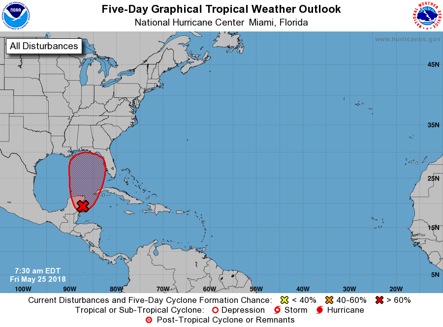
PWAT values, over the coming days, will be high. That means locally heavy rain is more likely. This is even more true if the tropical system in the Gulf of Mexico develops and moves into our region.

Interactive Radars:
Interactive live weather radar page. Choose the city nearest your location. If one of the city radars won’t load then try a nearby one. Click here.

Questions? Broken links? Other?
You may email me at beaudodson@usawx.com

The National Weather Service defines a severe thunderstorm as one that produces quarter size hail or larger, 58 mph winds or greater, and/or a tornado.
Friday through Monday night Thunderstorms are possible over the coming days. For those who end up underneath one of these thunderstorms you can expect heavy rain, gusty winds, small hail, and lightning. Isolated reports of flash flooding are possible. An isolated report of high winds would be possible. The threat of severe weather is rather low.
Tuesday into Thursday: Locally heavy thunderstorms are again possible. I will be monitoring a tropical system moving northward out of the Gulf of Mexico. PWAT values will be high. That means heavy rain. I can’t rule out down-burst winds.
![]()
Interactive live weather radar page. Choose the city nearest your location. If one of the cities does not work then try a nearby one. Click here.
National map of weather watches and warnings. Click here.
Storm Prediction Center. Click here.
Weather Prediction Center. Click here.

Live lightning data: Click here.

Interactive GOES R satellite. Track clouds. Click here.

Here are the latest local river stage forecast numbers Click Here.
Here are the latest lake stage forecast numbers for Kentucky Lake and Lake Barkley Click Here.

The spring and preliminary summer outlooks have been posted for subscribers. Scroll down to see the outlook.
Not a subscriber? Learn more at this link.

Weather Headlines.
- A period of showers and storms today/tonight
- Scattered storms Saturday into Sunday
- At this time, rain chances on Monday appear low. Widely scattered storms perhaps.
- Monitoring the tropics.
Welcome to the holiday weekend! Our official kickoff to summer.

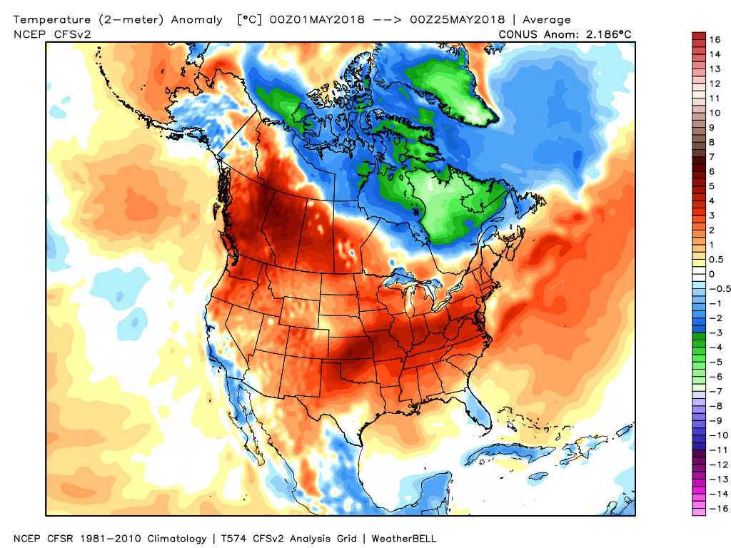
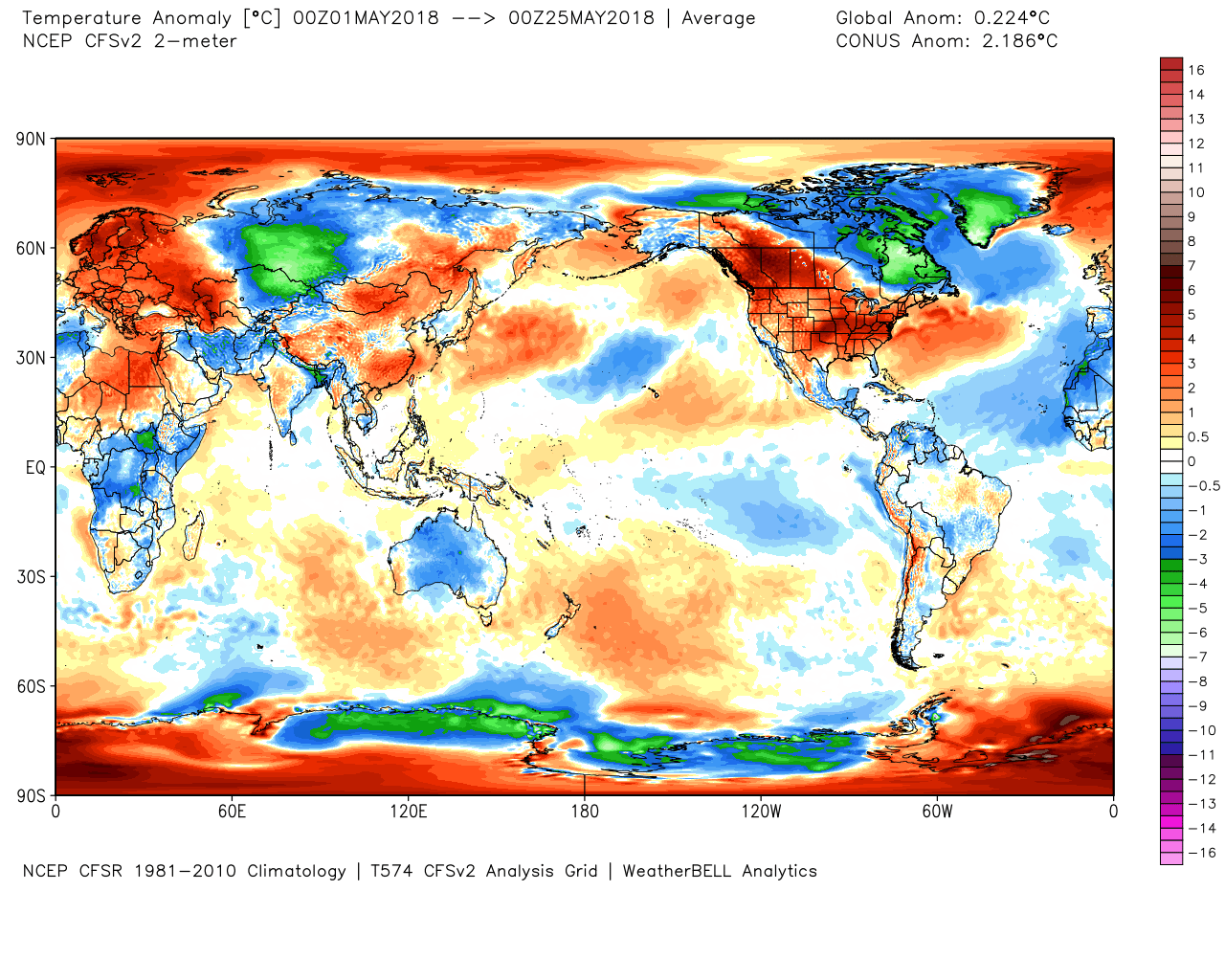
It is going to feel like summer over the coming days. Wow, has May been warm! Well above normal temperatures. This will likely be one of our warmer Month of Mays on record. We will have to wait for the official stats to be posted.
Here is the month to date temperature anomaly maps.
North America
World
Not everyone is warm! The blue and green colors are below to well below normal temperatures.
It is going to be warm today into Monday. Humid, as well.
If you have outdoor plans then remember a few items. Sun screen. Where the sun shines the UV index will pop into the 8 to 11 range. Sunburn will be a concern.
We will have a chance of showers and thunderstorms today into Sunday night. The best chance will likely be this afternoon into this evening and again on Saturday. Throw a towel and umbrella in the car.
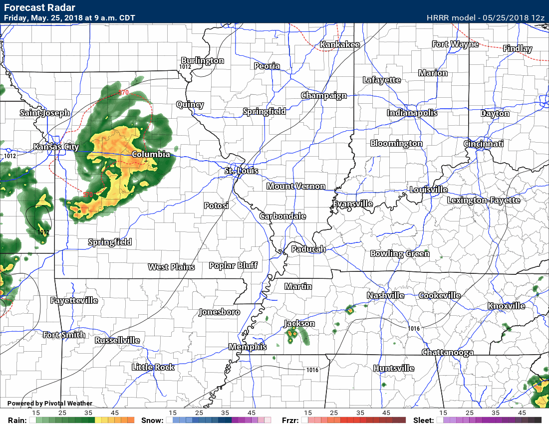
A line of showers and thunderstorms will be possible today. That line will move across southeast Missouri and then into southern Illinois and western Kentucky/Tennessee.
It won’t rain all day. Plan on a period of precipitation.
Here is the Hrrr model guidance future-cast radar. Now, as always, this won’t be exact. Models don’t handle these types of patterns all that well.
Take the general idea. A period of showers and thunderstorms will be possible this afternoon and evening.
Time-stamp upper left
Scattered storms are again possible Saturday into Sunday afternoon. Chances decrease as we move into Sunday night and Monday.
Monday will deliver hot and humid conditions. A widely scattered storm is possible.
I would not cancel any plans this weekend. I would suggest monitoring radars. Some storms will occur. Someone will pick up heavy downpours (typical summer type storms). When storms occur, seek shelter until they pass. Lightning is always a concern during the summer months. Give the storm some time to do its thing and exit.
There is a low risk that a storm could pulse up to near severe levels. The concern would be down-burst winds and dime to nickel size hail. gain, heavy rain and lightning, of course.
Highs today into Monday will range from 85 to 90 degrees. Overnight lows will mostly be in the 65 to 70 degree range. Above the seasonal norms.
I am closely watching a developing tropical system in the Gulf of Mexico. This system is forecast to strengthen over the next few days as it heads north.
Our weather will be highly dependent on the strength of the tropical system and the eventual track onshore. We may have to deal with rain from this system. Monitor updates. Heavy rain will occur along its path. Severe weather is also possible along the path of the developing tropical system.
The National Hurricane Center says there is a 90% chance that this system becomes a tropical depression or greater.
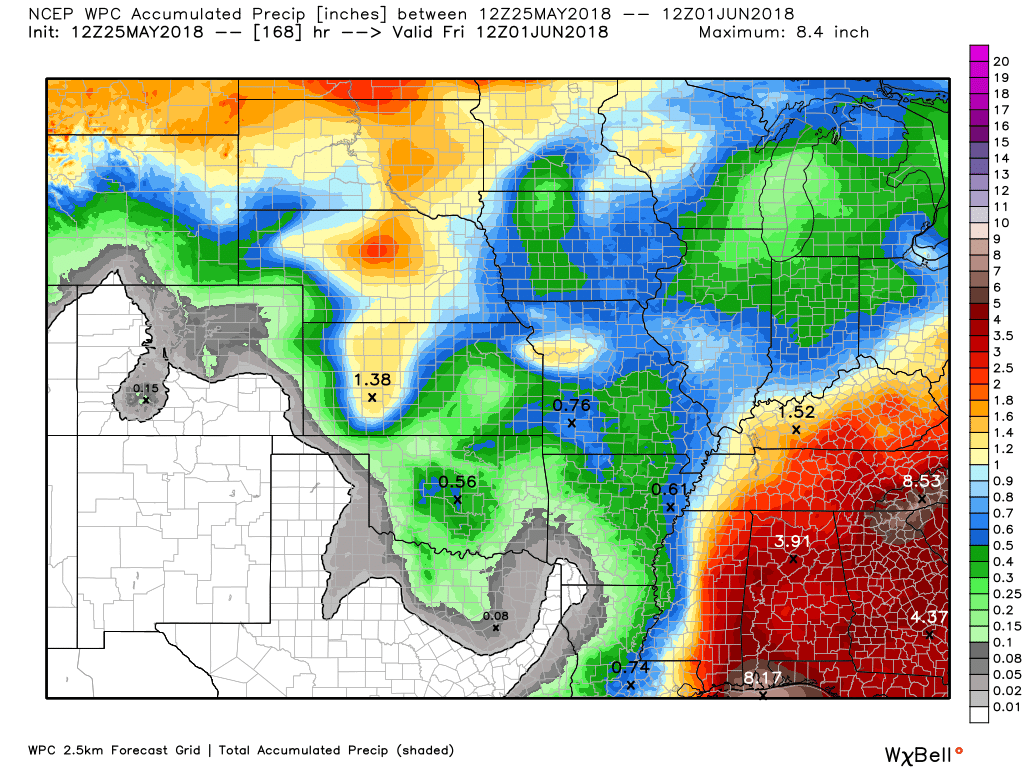
Here is the WPC seven day rainfall map. Notice the heaviest rain to our south and southeast. This is HIGHLY dependent on the track of the tropical system.
If that system shifts westward then our rain totals will increase.
Also, keep in mind, this graphic won’t pick up on locally heavy thunderstorms. Thunderstorms can produce a quick one to two inches of rain in less than an hour. That will skew these numbers.
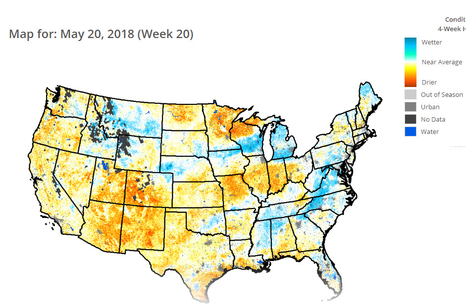
The quick drought response index is showing some concerns. We don’t want this potential drought to become a problem. If this hot weather continues into June and July then drought may be a problem.
Those orange and yellow areas represent drier ground moisture regions. It is worse to our north. We have been receiving periodic rains.
![]()

A new weather podcast is now available! Weather Geeks (which you might remember is on The Weather Channel each Sunday)
To learn more visit their website. Click here.
![]()

WeatherBrains Episode 643
Tonight’s Guest WeatherBrain is a Research Meteorologist at National Severe Storms Laboratory and a visiting Professor of Atmospheric Science at Desert Research Institute and the University of Nevada-Reno. He is the author of the recent AMS Book: Verner Soumi: The Life and Work of the Founder of Satellite Meteorology. He joins us tonight from his daughter’s home in Sacramento. Please welcome Dr. John Lewis to WeatherBrains.
Throughout his career, Dr. Lewis has conducted research that has combined weather analysis with numerical weather prediction. His professional experience has been divided between work in government labs including operational prediction centers and academia. In the past decade, he has led a national research project focused on the weather over the Gulf of Mexico, Project GUFMEX, explored the use of adjoint methods to study model sensitivity, and contributed to the history of science. In 1998, the Environmental Research Laboratories of NOAA assigned Dr. Lewis to Desert Research Institute on a long-term duty assignment. This assignment was made in connection with a 5-year plan to improve weather forecasting in the Western United States. Central to this effort is the use of adjoint models to clarify the relative importance of the various meteorological fields used to initialize deterministic prediction models.
Other discussions in this weekly podcast include topics like:
- Extremes: 102 at Rio Grande Village, TX, and 23 at Stanley, ID, Crested Butte, CO, & Gothic, CO
- Non-tropical low off the west coast of Florida
- Severe weather Tuesday over Mid-Atlantic states
- Serious drought from AZ to West TX
- Fairly warm across the continental US
- Astronomy Outlook with Tony Rice
- and more!
Previous episodes can be viewed by clicking here.

We offer interactive local city live radars and regional radars. If a radar does not update then try another one. If a radar does not appear to be refreshing then hit Ctrl F5. You may also try restarting your browser.
The local city view radars also have clickable warnings.
During the winter months, you can track snow and ice by clicking the winterize button on the local city view interactive radars.
You may email me at beaudodson@usawx.com
Find me on Facebook!

Find me on Twitter!

Did you know that a portion of your monthly subscription helps support local charity projects?
You can learn more about those projects by visiting the Shadow Angel Foundation website and the Beau Dodson News website.

I encourae subscribers to use the app vs regular text messaging. We have found text messaging to be delayed during severe weather. The app typically will receive the messages instantly. I recommend people have three to four methods of receiving their severe weather information.
Remember, my app and text alerts are hand typed and not computer generated. You are being given personal attention during significant weather events.
