
.

This forecast update covers far southern Illinois, far southeast Missouri, and far western Kentucky. See the coverage map on the right side of the blog
..
Sunday Night Forecast Details:
Forecast: Clearing of any remaining clouds and cooler. Patchy fog.
Temperatures: MO ~ 48 to 54 IL ~ 48 to 54 KY ~ 48 to 54 TN ~ 50 to 55
Winds: Northwest winds at 0 to 6 mph.
My confidence in the forecast verifying: High. This forecast should verify.
What impacts are anticipated from the weather? Patchy fog possible.
Is severe weather expected? No.
The NWS defines severe weather as 58 mph winds or great, 1″ hail or larger, and/or tornadoes
What is the chance of precipitation? MO ~ 0% IL ~ 0% KY ~ 0% TN ~ 0%
Coverage of precipitation: None.
Should I cancel my outdoor plans? No.
.
May 22, 2017
Monday Forecast Details
Forecast: A mix of sun and clouds. Some chance for clouds to push northward from Arkansas and Tennessee. Cooler.
Temperatures: MO ~ 72 to 76 IL 74 to 78 KY 74 to 78 TN 74 to 78
Winds: East and northeast winds at 4 to 8 mph with gusts to 12 mph
What impacts are anticipated from the weather? None
My confidence in the forecast verifying: High. This forecast should verify.
Is severe weather expected? No
The NWS defines severe weather as 58 mph winds or great, 1″ hail or larger, and/or tornadoes
What is the chance of precipitation? MO ~ 0% IL ~ 0% KY ~ 0% TN ~ 0%
Coverage of precipitation: None
Should I cancel my outdoor plans? No
.
Monday Night Forecast Details:
Forecast: Increasing clouds. A 40% for showers and thunderstorms.
Temperatures: MO ~ 54 to 58 IL ~ 54 to 58 KY ~ 54 to 58 TN ~ 54 to 58
Winds: Variable at 0 to 5 mph.
My confidence in the forecast verifying: High. This forecast should verify
What impacts are anticipated from the weather? Wet roadways. Lightning.
Is severe weather expected? No
The NWS defines severe weather as 58 mph winds or great, 1″ hail or larger, and/or tornadoes
What is the chance of precipitation? MO ~ 40% IL ~ 40% KY ~ 40% TN ~ 40%
Coverage of precipitation: Scattered
Should I cancel my outdoor plans? No, but perhaps check radars.
.
May 23, 2017
Tuesday Forecast Details
Forecast: Mostly cloudy. A few showers and perhaps a thunderstorm.
Temperatures: MO ~ 72 to 76 IL 72 to 76 KY 72 to 76 TN 72 to 78
Winds: South and southwest winds at 5 to 10 mph.
What impacts are anticipated from the weather? Wet roadways. Perhaps lightning.
My confidence in the forecast verifying: Medium. Some adjustments are possible.
Is severe weather expected? No
The NWS defines severe weather as 58 mph winds or great, 1″ hail or larger, and/or tornadoes
What is the chance of precipitation? MO ~ 50% IL ~ 50% KY ~ 50% TN ~ 50%
Coverage of precipitation: Scattered
Should I cancel my outdoor plans? Monitor updates.
.
Tuesday Night Forecast Details:
Forecast: Cloudy. Showers possible.
Temperatures: MO ~ 50 to 55 IL ~ 48 to 54 KY ~ 52 to 56 TN ~ 52 to 56
Winds: Northwest 5 to 10 mph with gusts to 15 mph.
My confidence in the forecast verifying: Medium. Some adjustments are possible.
What impacts are anticipated from the weather? Wet roadways.
Is severe weather expected? No.
The NWS defines severe weather as 58 mph winds or great, 1″ hail or larger, and/or tornadoes
What is the chance of precipitation? MO ~ 40% IL ~ 40% KY ~ 40% TN ~ 40%
Coverage of precipitation: Scattered to perhaps numerous at times.
Should I cancel my outdoor plans? No, but monitor updates.
.
May 24, 2017
Wednesday Forecast Details
Forecast: Partly to mostly cloudy. A chance for a few showers.
Temperatures: MO ~ 64 to 68 IL 64 to 68 KY 64 to 68 TN 65 to 70
Winds: Northwest at 10 mph.
What impacts are anticipated from the weather? Wet roadways.
My confidence in the forecast verifying: Medium. Some adjustments are possible.
Is severe weather expected? No
The NWS defines severe weather as 58 mph winds or great, 1″ hail or larger, and/or tornadoes
What is the chance of precipitation? MO ~ 30% IL ~ 30% KY ~ 30% TN ~ 30%
Coverage of precipitation: Scattered
Should I cancel my outdoor plans? Monitor updated forecasts
.
Wednesday Night Forecast Details:
Forecast: Partly cloudy. A slight chance for an evening shower. Cooler.
Temperatures: MO ~ 46 to 52 IL ~ 45 to 52 KY ~ 46 to 52 TN ~ 48 to 54
Winds: Northwest at 5 mph with gusts to 10 mph.
My confidence in the forecast verifying: Medium. Some adjustments are possible.
What impacts are anticipated from the weather? Wet roadways.
Is severe weather expected? No
The NWS defines severe weather as 58 mph winds or great, 1″ hail or larger, and/or tornadoes
What is the chance of precipitation? MO ~ 20% IL ~ 20% KY ~ 30% TN ~ 30%
Coverage of precipitation: Widely scattered
Should I cancel my outdoor plans? No.
.
May 25, 2017
Thursday Forecast Details
Forecast: Partly cloudy. A slight chance for showers.
Temperatures: MO ~ 68 to 74 IL 68 to 74 KY 70 to 75 TN 70 to 75
Winds: West and northwest at 5 to 10 mph.
What impacts are anticipated from the weather? None.
My confidence in the forecast verifying: Low. Significant adjustments are possible.
Is severe weather expected? No
The NWS defines severe weather as 58 mph winds or great, 1″ hail or larger, and/or tornadoes
What is the chance of precipitation? MO ~ 10% IL ~ 20% KY ~ 30% TN ~ 20%
Coverage of precipitation: Isolated
Should I cancel my outdoor plans? No
.
Thursday Night Forecast Details:
Forecast: Partly cloudy.
Temperatures: MO ~ 48 to 54 IL ~ 48 to 54 KY ~ 50 to 55 TN ~ 50 to 55
Winds: West and southwest winds at 5 mph.
My confidence in the forecast verifying: Low. Significant adjustments are possible.
What impacts are anticipated from the weather?
Is severe weather expected? No
The NWS defines severe weather as 58 mph winds or great, 1″ hail or larger, and/or tornadoes
What is the chance of precipitation? MO ~ 10% IL ~ 10% KY ~ 10% TN ~ 10%
Coverage of precipitation: Most likely none.
Should I cancel my outdoor plans? No
.
May 26, 2017
Friday Forecast Details
Forecast: Partly cloudy.
Temperatures: MO ~ 74 to 78 IL 74 to 78 KY 74 to 78 TN 74 to 78
Winds: Southwest wind at 5 to 10 mph.
What impacts are anticipated from the weather? None.
My confidence in the forecast verifying: Low. Significant adjustments are possible.
Is severe weather expected? No
The NWS defines severe weather as 58 mph winds or great, 1″ hail or larger, and/or tornadoes
What is the chance of precipitation? MO ~ 10% IL ~ 10% KY ~ 10% TN ~ 10%
Coverage of precipitation: Most likely none.
Should I cancel my outdoor plans? No
.
Friday Night Forecast Details:
Forecast: Partly cloudy. A chance for showers and thunderstorms.
Temperatures: MO ~ 60 to 64 IL ~ 58 to 64 KY ~ 60 to 65 TN ~ 60 to 65
Winds: Southwest at 5 mph with gusts to 10 mph.
My confidence in the forecast verifying: Low. Significant adjustments are possible.
What impacts are anticipated from the weather?
Is severe weather expected? Unlikely
The NWS defines severe weather as 58 mph winds or great, 1″ hail or larger, and/or tornadoes
What is the chance of precipitation? MO ~ 30% IL ~ 20% KY ~ 20% TN ~ 20%
Coverage of precipitation: Monitor.
Should I cancel my outdoor plans? Monitor
.
May 27, 2017
Saturday Forecast Details
Forecast: Partly cloudy. A chance for showers and thunderstorms.
Temperatures: MO ~ 76 to 82 IL 76 to 82 KY 76 to 82 TN 76 to 82
Winds: Southwest wind at 5 to 10 mph.
What impacts are anticipated from the weather? Wet roadways. Lightning.
My confidence in the forecast verifying: Low. Significant adjustments are possible.
Is severe weather expected? Monitor updates.
The NWS defines severe weather as 58 mph winds or great, 1″ hail or larger, and/or tornadoes
What is the chance of precipitation? MO ~ 30% IL ~ 30% KY ~ 30% TN ~ 30%
Coverage of precipitation: Scattered
Should I cancel my outdoor plans? No, but monitor updates.
.
Saturday Night Forecast Details:
Forecast: Partly cloudy. A chance for showers and thunderstorms.
Temperatures: MO ~ 65 to 70 IL ~ 65 to 70 KY ~ 65 to 70 TN ~ 65 to 70
Winds: Southwest at 5 mph with gusts to 10 mph.
My confidence in the forecast verifying: Low. Significant adjustments are possible.
What impacts are anticipated from the weather? Wet roadways. Lightning.
Is severe weather expected? Monitor updates.
The NWS defines severe weather as 58 mph winds or great, 1″ hail or larger, and/or tornadoes
What is the chance of precipitation? MO ~ 30% IL ~ 20% KY ~ 20% TN ~ 20%
Coverage of precipitation: Scattered.
Should I cancel my outdoor plans? No, but monitor updates.
.
May 28, 2017
Sunday Forecast Details
Forecast: Partly cloudy. A chance for showers and thunderstorms.
Temperatures: MO ~ 74 to 78 IL 74 to 78 KY 74 to 78 TN 74 to 78
Winds: Southwest wind at 5 to 10 mph.
What impacts are anticipated from the weather? Wet roadways. Lightning.
My confidence in the forecast verifying: Low. Significant adjustments are possible.
Is severe weather expected? Monitor updates.
The NWS defines severe weather as 58 mph winds or great, 1″ hail or larger, and/or tornadoes
What is the chance of precipitation? MO ~ 30% IL ~ 30% KY ~ 30% TN ~ 30%
Coverage of precipitation: Scattered
Should I cancel my outdoor plans? No, but monitor updates.
.
Sunday Night Forecast Details:
Forecast: Partly cloudy.
Temperatures: MO ~ 65 to 70 IL ~ 65 to 70 KY ~ 65 to 70 TN ~ 65 to 70
Winds: Southwest at 5 mph with gusts to 10 mph.
My confidence in the forecast verifying: Low. Significant adjustments are possible.
What impacts are anticipated from the weather?
Is severe weather expected?
The NWS defines severe weather as 58 mph winds or great, 1″ hail or larger, and/or tornadoes
What is the chance of precipitation? MO ~ 10% IL ~ 10% KY ~ 10% TN ~ 10%
Coverage of precipitation:
Should I cancel my outdoor plans?
,
.
Don’t forget to check out the Southern Illinois Weather Observatory web-site for weather maps, tower cams, scanner feeds, radars, and much more! Click here
.

An explanation of what is happening in the atmosphere over the coming day
.

A severe thunderstorm is defined as a storm that produces quarter size hail or larger, 58 mph winds or greater, and/or a tornado. That is the official National Weather Service definition of a severe thunderstorm.
Sunday night through Friday night: At this time, severe weather is not anticipated. We will, however, have a few chances for lightning (see the day by day forecast above). I am monitoring Friday or Friday night for a possible thunderstorm complex in the region. Low confidence, this far out.
Weather Analysis for the coming week:
Wondering what happened to the Sunday evening storms? Scroll further down for an explanation.
Sunday night into Monday:
Our storm system has moved off to the east. We had a few early morning showers over the area, but they quickly moved eastward.
The morning hours wet met with full sunshine over portions of the area. Others were socked in with clouds.
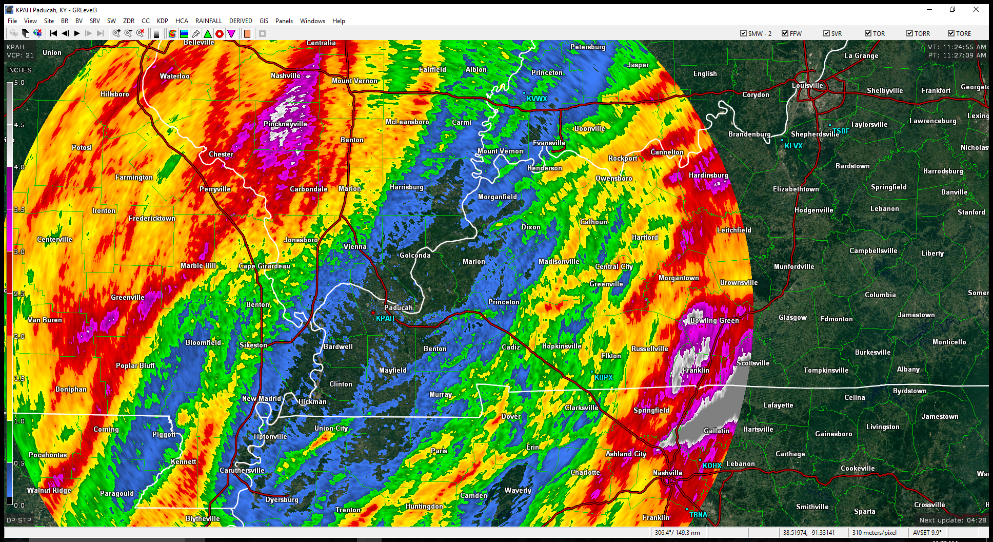
Here was the 9 am satellite view. White would be clouds. Black would be clear sky conditions.
![]()
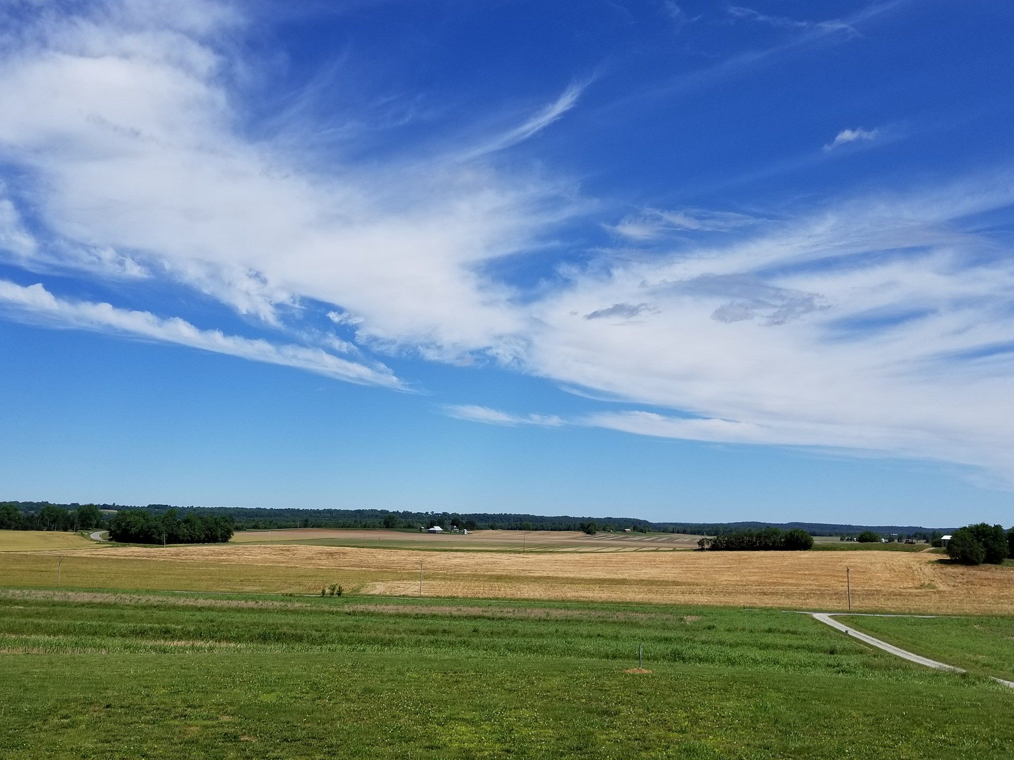
I took this photograph outside of the Weather Observatory on Sunday morning. Beautiful sky. Massac County, Illinois.
Rainfall totals over the last three days. Some areas had three inches (or more). Some areas had barely a trace of rain.
The forecast was for widespread 0.50″ to 1.00″ with areas that could double or triple that in slow moving thunderstorms.
The week ahead
We are going to have a bit of mixed weather during the upcoming week. On and off clouds. On and off showers and a few thunderstorms. On and off sun.
It will be a bit tricky forecasting the time periods with the greatest rain chances. At least until we draw closer to the time frame.
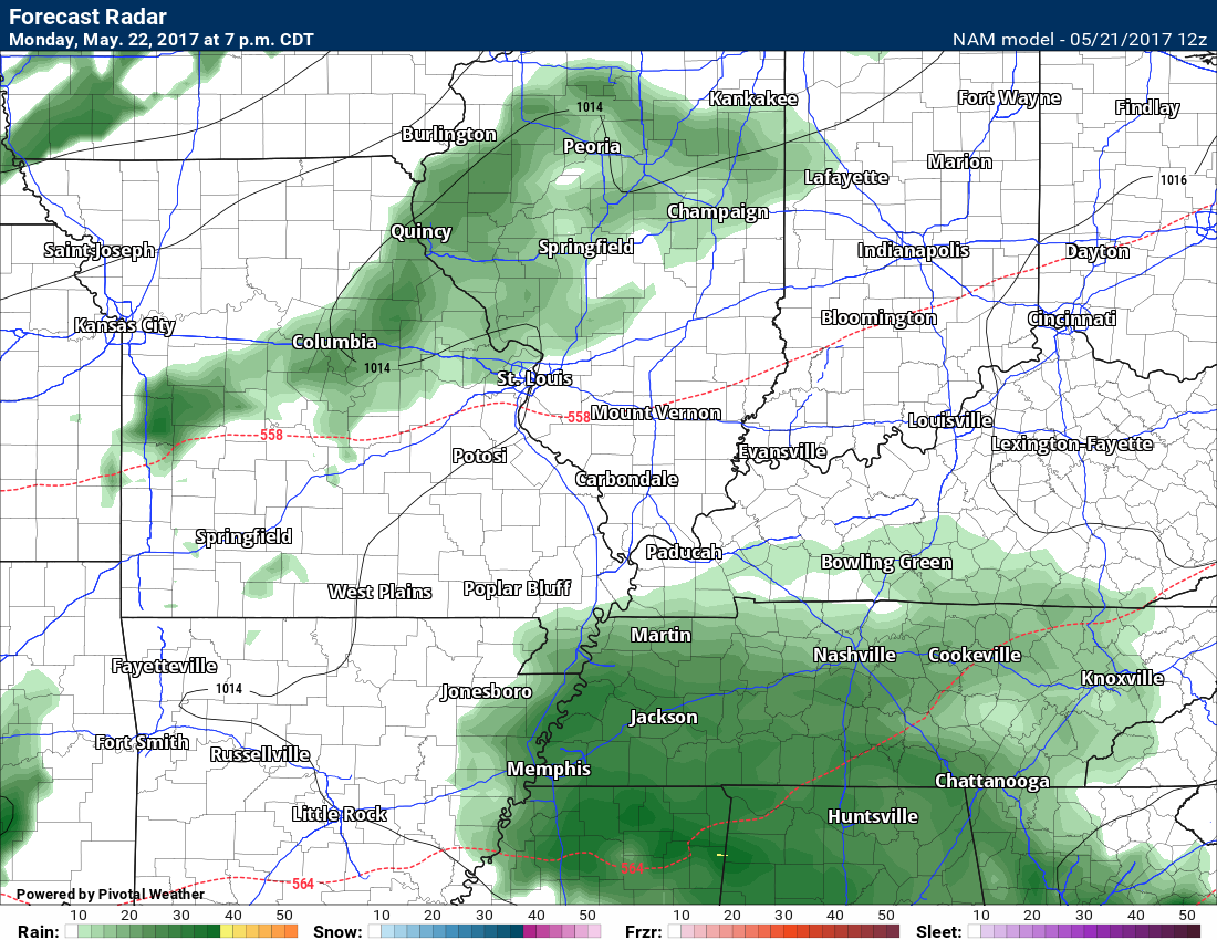
A few patchy showers could form as early as Monday night over southeast Missouri. Chances should be a little higher on Tuesday/Tuesday night.
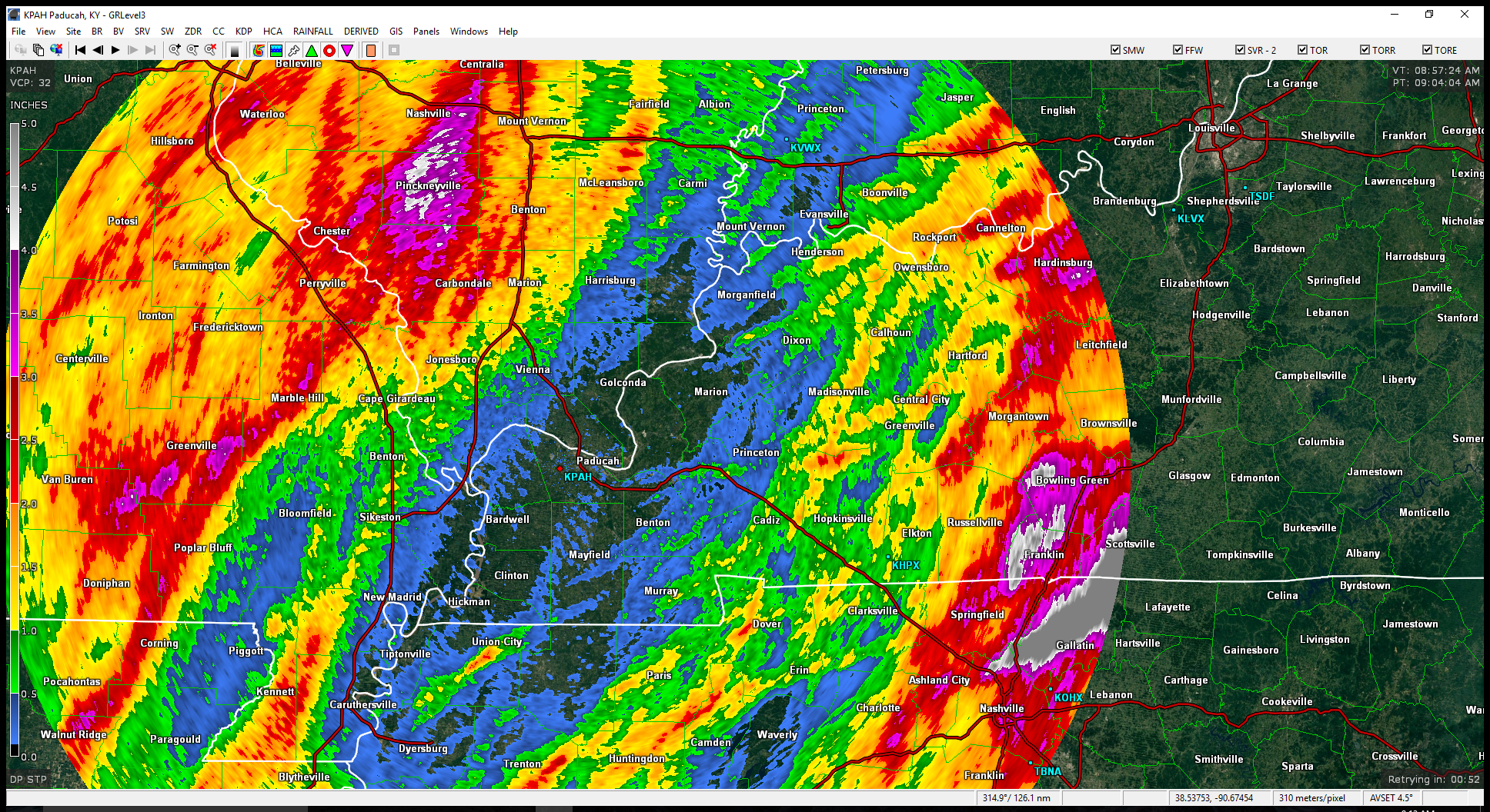
Here is what the NAM guidance is showing for future-cast radar. This is for 7 pm on Monday.
NAM pops some showers in Tennessee and then our northern counties. We will see how it goes. Confidence on placement of rain Monday evening is rather low. I capped chances at 40% for the time being.
Here is the 10 pm Tuesday radar from the NAM guidance.
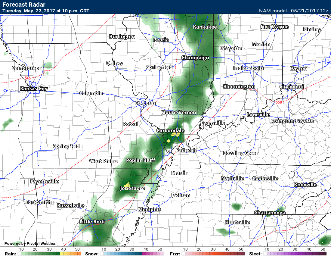
I can’t rule out showers on Wednesday/Wednesday night, as well.
Here is the NAM guidance for 10 am on Wednesday. You can see a band of showers moving through the area. Remember, this is just one models opinion. Confidence is rather low on coverage of precipitation. There will at least be some risk for a few showers and storms.

Some guidance shows a few showers on Thursday. Again, confidence is rather low. I am sure confidence will grow as we move closer to each of the precipitation events.
Another system is forecast to take shape to our southwest on Friday and Friday night. Yes, another weekend storm system to monitor.
We are stuck on weekend rain. So it seems.
This system could produce heavier storms and we need to keep an eye on it.
Too early for confidence to be all that high on the timing of precipitation.
I am also monitoring for the potential of thunderstorm complexes, these are called MCS’s, towards the end of the week. These complexes are difficult to forecast 24 hours out, let alone days out.
MCS’s can produce widespread rain and storms. They are responsible for much of the corn belt’s rainfall totals during the summer months. We are entering MCS season. They typically ride up and around the summer ridge of high pressure. Depending where you are, in relation to the ridge, determines your forecast.
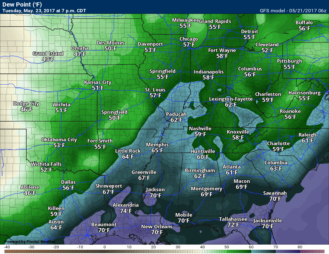
Watch the change in dew points, according to the GFS guidance, from now through next weekend.
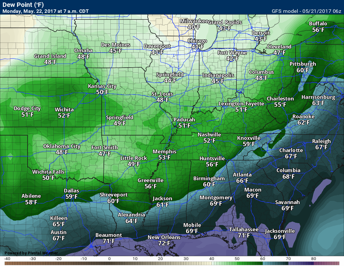
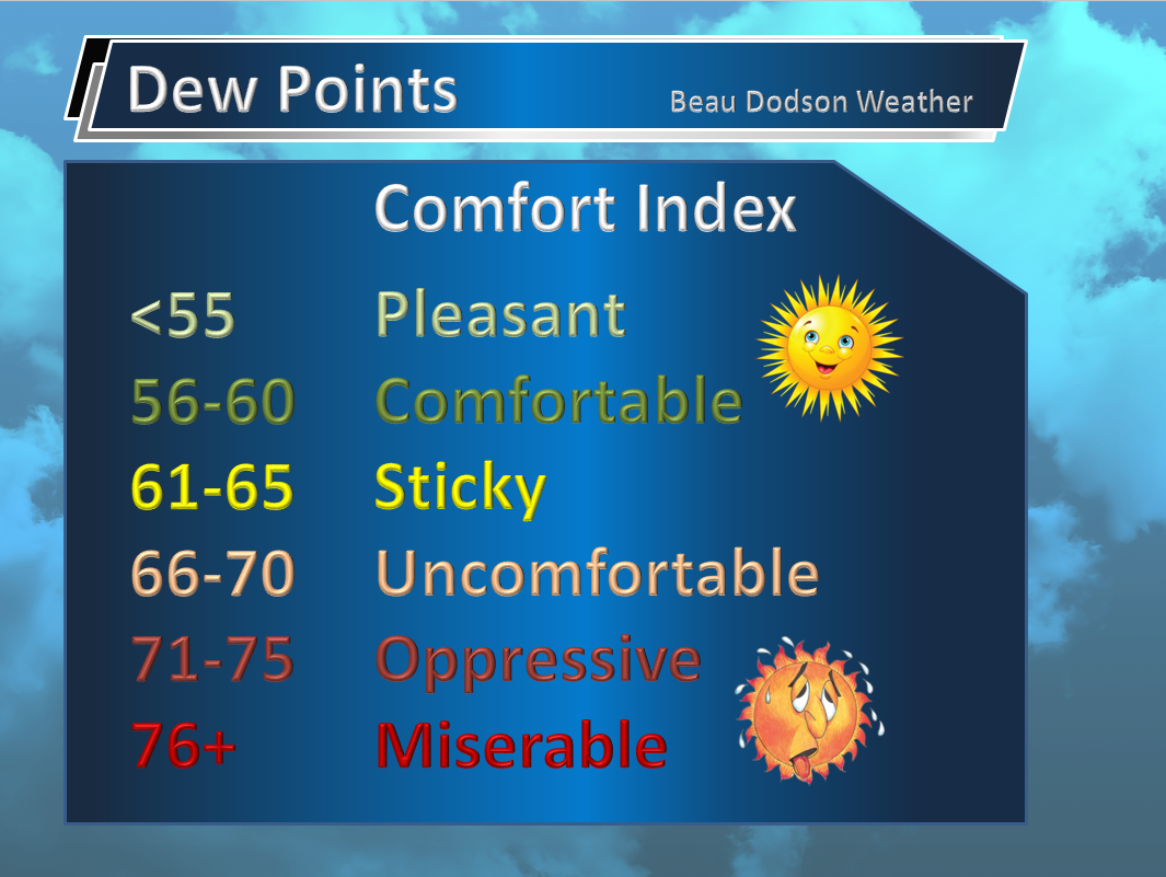
Here is the Sunday night/Monday morning dew point map. Dew points are a measure of moisture in the lower atmosphere. The higher the numbers the higher the moisture content of the atmosphere.
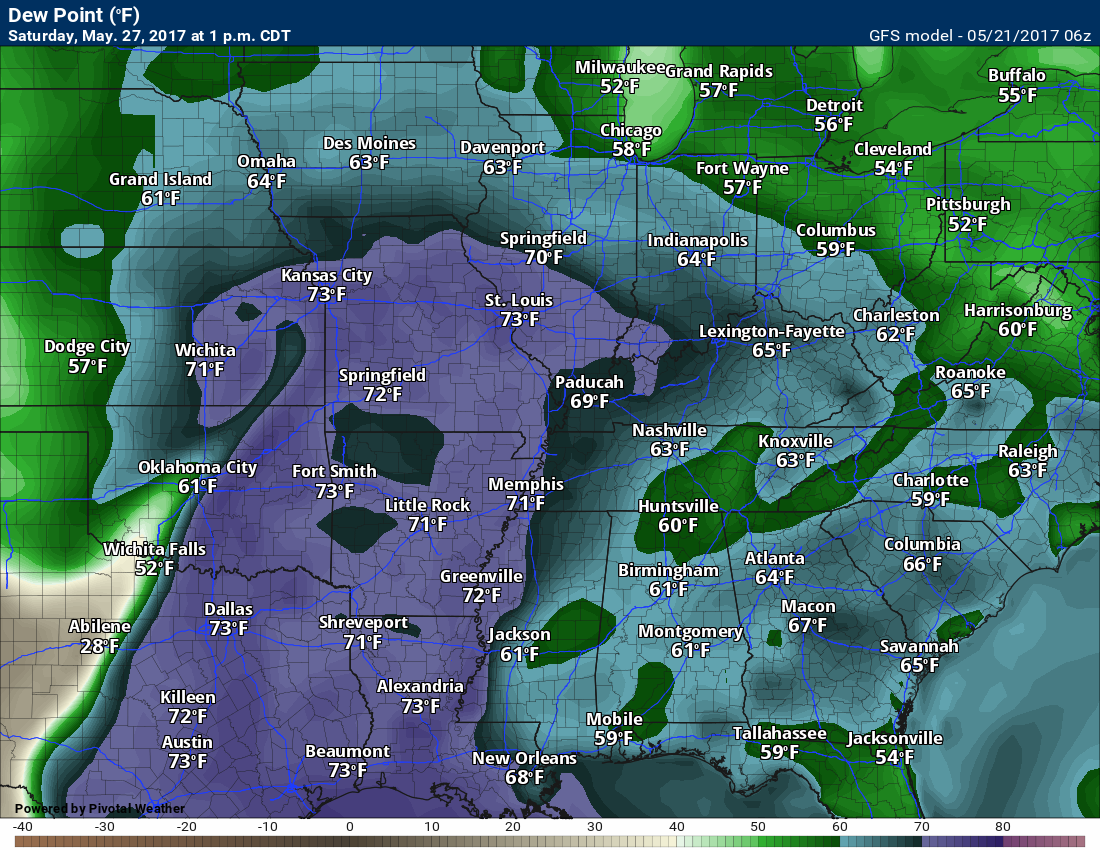
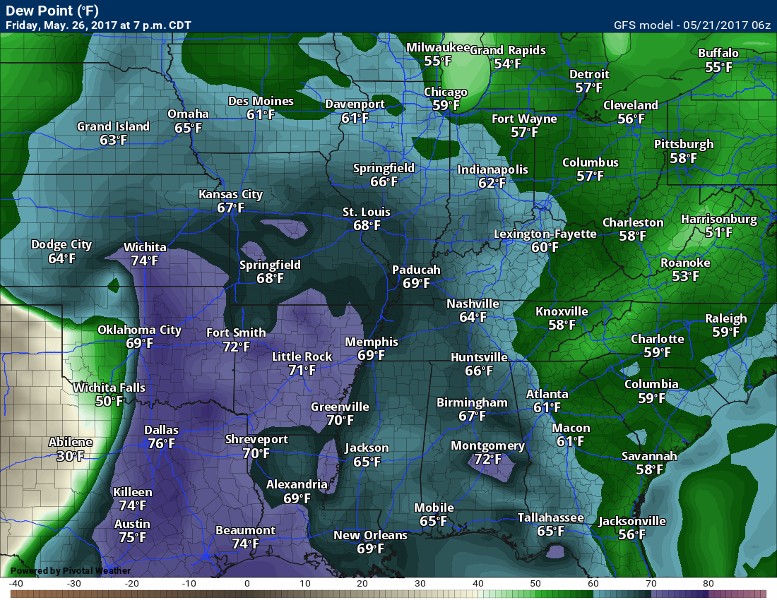
Now, look at next weekend (Saturday). Big difference.
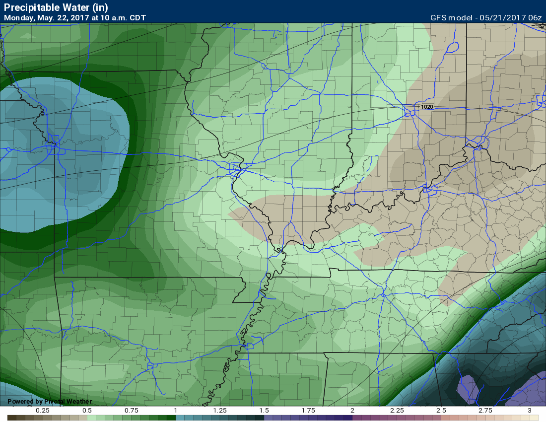
PWAT values will also be on the rise. Remember, PWAT values are a measure of moisture for the entire atmosphere. Top to bottom. The higher the numbers the greater the risk for heavy rain.
Here is the Monday PWAT map. Monday, May 22nd. Low numbers.
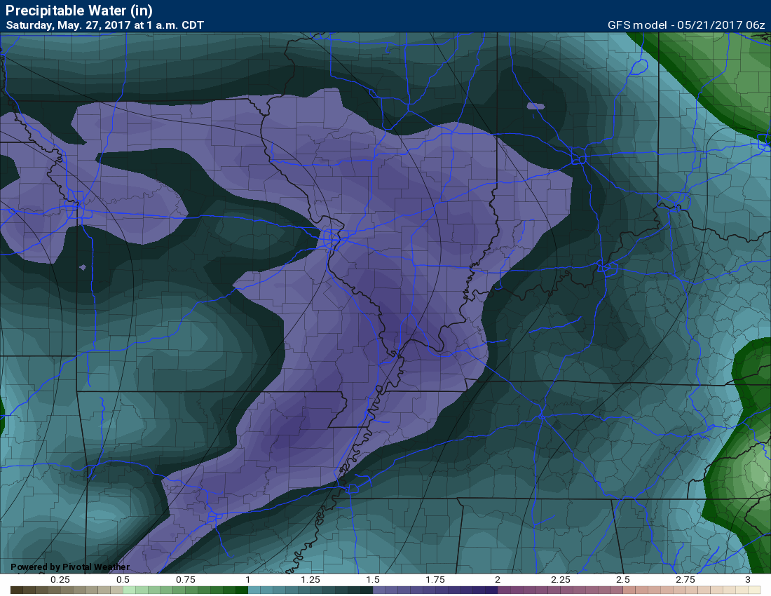
Here are the PWAT numbers for Saturday, May 27th. Dramatic changes. Lot of moisture to work with. Locally heavy rain would be a concern. Still several days to monitor.
Here is the map for Sunday, May 28th. Lot of moisture.

Let’s take a look at the 500 mb vorticity map. These will show you the little disturbances that will move quickly through the region over the coming week. Again, tricky forecasting these small fast moving systems.
Here is the map for early Wednesday morning. The colors represent the intensity of the vorts.
The one on Tuesday night and Wednesday morning is fairly potent, but there is some question on dew points (moisture).
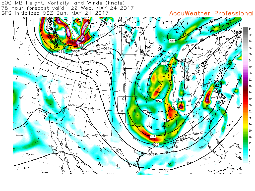
Speaking of dew points. Here is the Wednesday morning dew point map
Dew points of 62 and above is when it starts to feel humid outside. Dew points of 68 and above start feeling muggy.
These dew points would be sufficient to think about a few thunderstorms. Not anticipating severe weather.

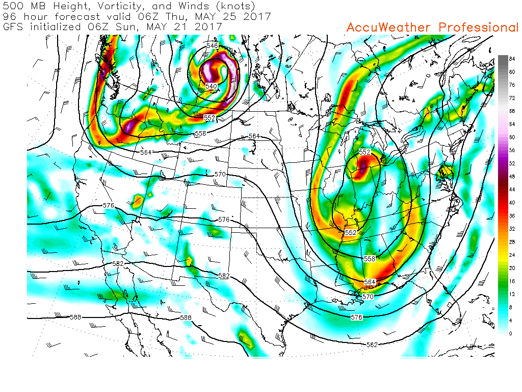
Here is the 500 mb vort map for Thursday morning at 12 am
We will have to monitor the timing of these disturbances. That will be the key to clouds and rain chances. Guidance is all over the place for Thursday. Some of the guidance shows sunshine and other guidance indicates showers and storms.
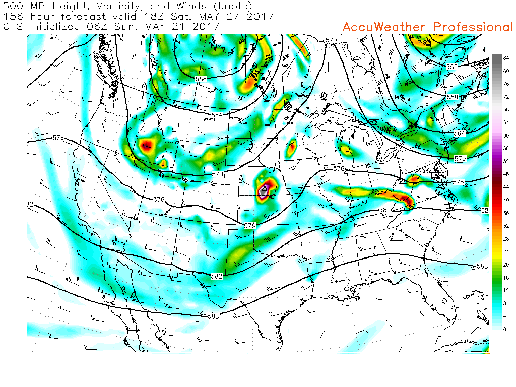
Moving ahead to Saturday. You can see a few vort maxes moving through the jet stream flow.
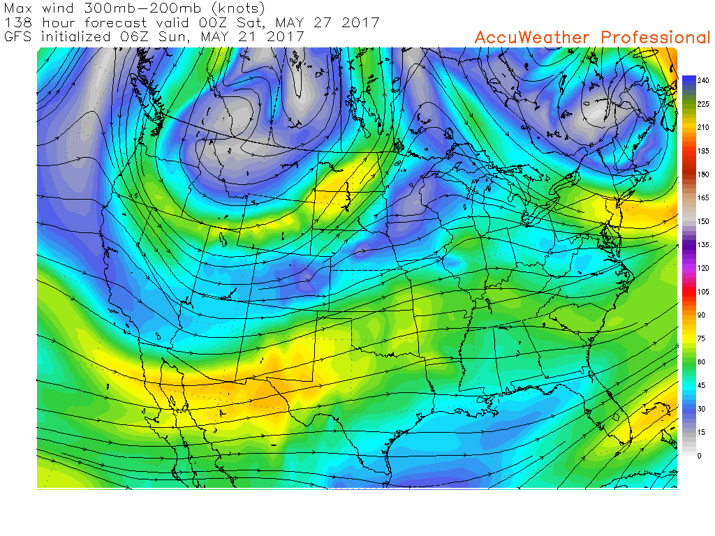
Let’s take a look at the jet stream.
This first map is the current jet stream. Notice how it dives into our region from the north. A nice trough over our region.

Here is the jet stream for next weekend. Notice how it is no longer diving in from the north. It is more southwesterly oriented.
Southwest flow typically indicates higher dew points and more moisture streaming into our region.
Let’s take a look at the change of dew points over the coming week. Again, dew points are a measure of moisture in the lower atmosphere.
Now let’s move to Tuesday at 7 pm. Notice some increase in dew points. Moisture attempting to move back northward ahead of the system that will move through our region.
Here is the dew point map for Friday at 7 pm. Big change. Notice the widespread dew points in the 60’s and even some 70’s in Arkansas.
Here is the dew point map for Saturday at 1 pm. Widespread upper 60’s to lower 70’s. Moist air.
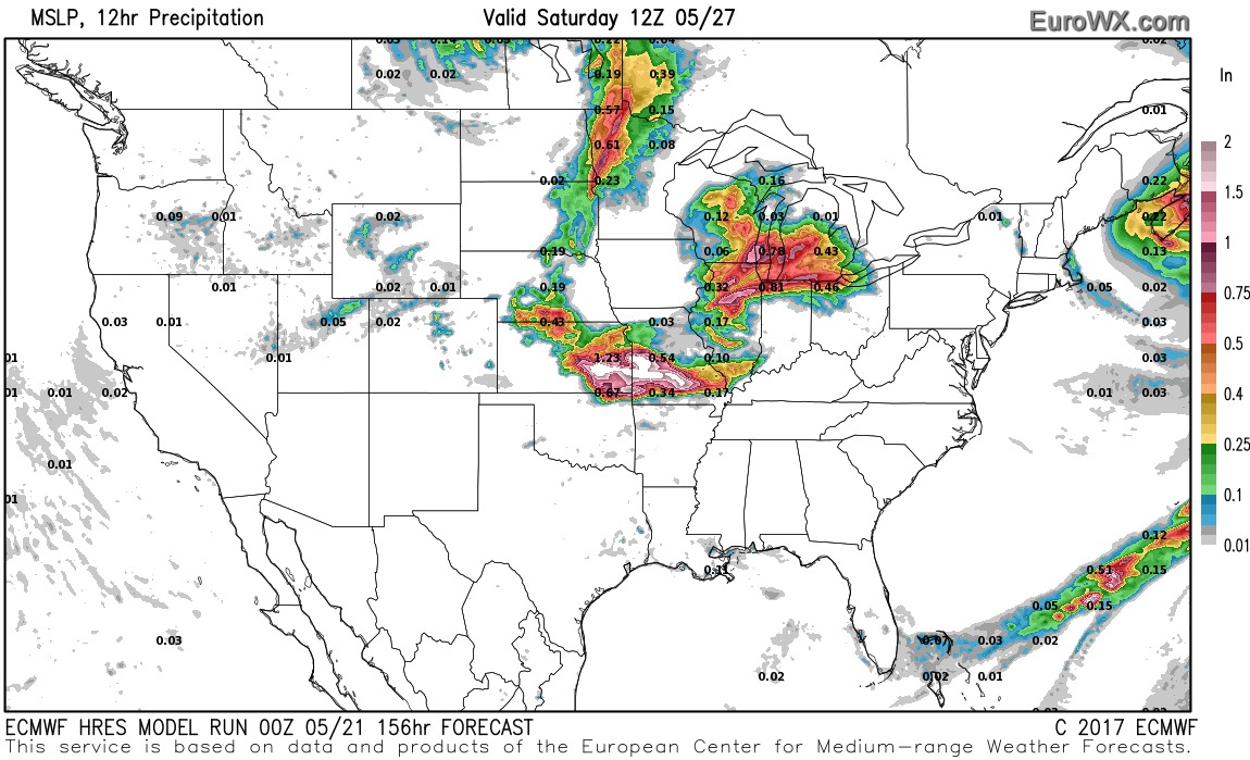
Here is one example of a possible MCS. This is the EC model guidance. You can see the large area of rain over Missouri. That is a complex of storms. Long way off, but I am monitoring the pattern.
There might be some CAPE to work with as we move towards the end of the work week. CAPE is energy for storms to tap into.
CAPE numbers, for most of this week, will remain low. Perhaps some hint of CAPE with the Tuesday/Wednesday system. Not anticipating severe weather. If the freezing level is low enough to you can receive pea to dime size hail (if storms form).
As we move towards the end of the week, however, the CAPE numbers are higher. Both the EC and GFS guidance indicate storms possible over the holiday weekend. Too soon for confidence, but I am monitoring the chances.
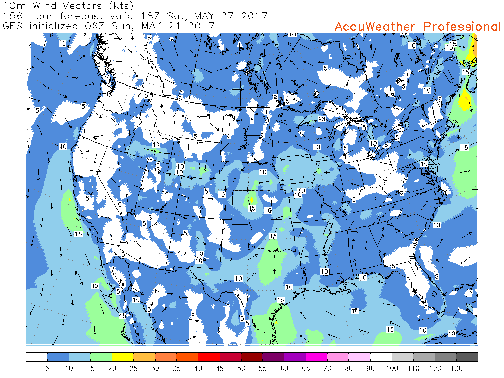
The wind vector map for Saturday and Sunday indicate moisture moving into the region from the Caribbean, Gulf of Mexico, and southwest. You can see those streamlines on the map below.
Wind vectors out of the Gulf of Mexico would support an increase in dew points.
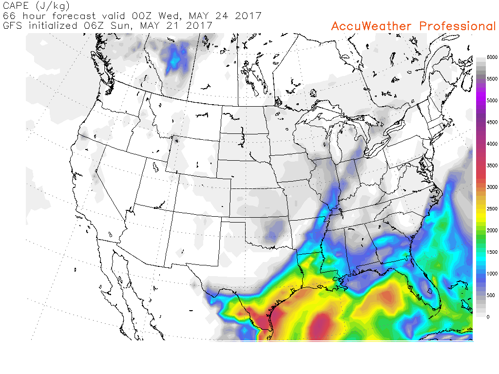
Let’s look at CAPE numbers
This first map is for Tuesday at 7 pm. Perhaps some low CAPE numerous. Lightning would be supported. If thunderstorms were to form, then they could also produce small hail.
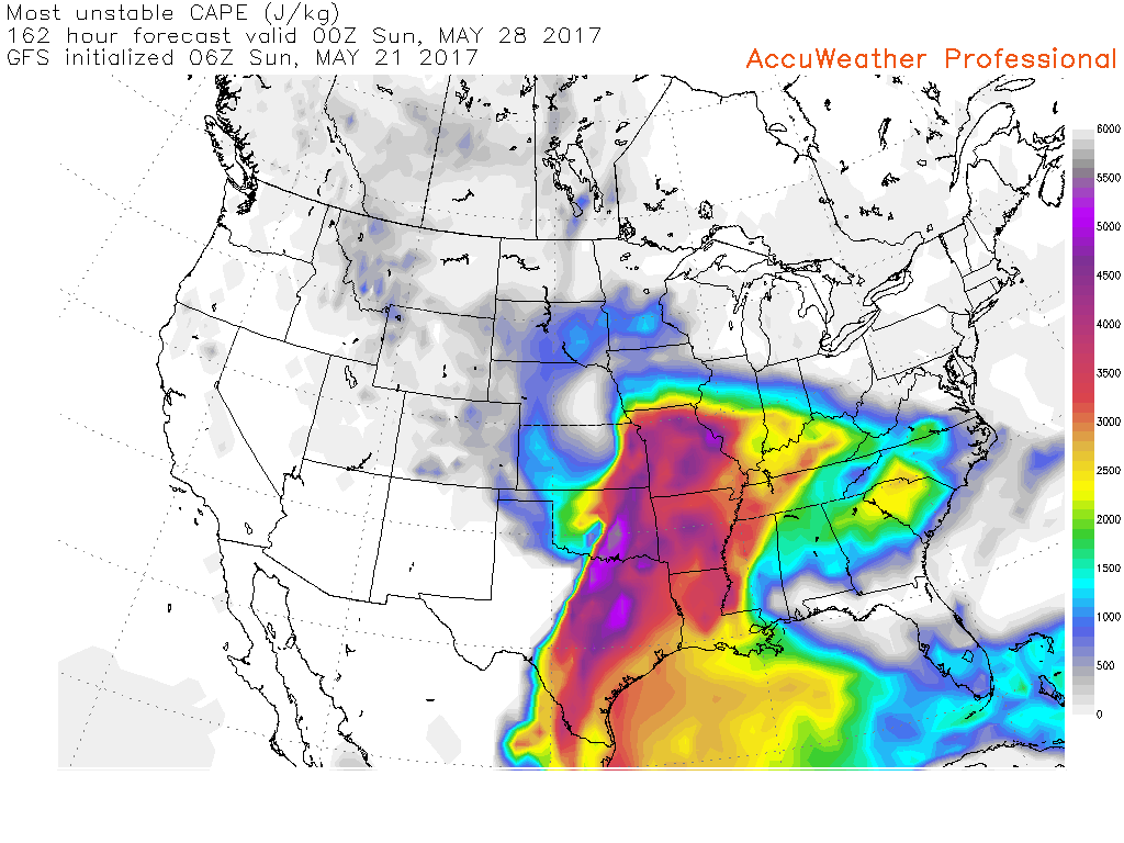
Look at the dramatic change in CAPE numbers as we move into next weekend.
These are the CAPE numerous for next Saturday night.
Lot of moving parts to the forecast. I will keep you updated as we move forward.
What happened to the Sunday evening storms? Let’s take a look.
I will post some graphics. The graphics will show you what happened.

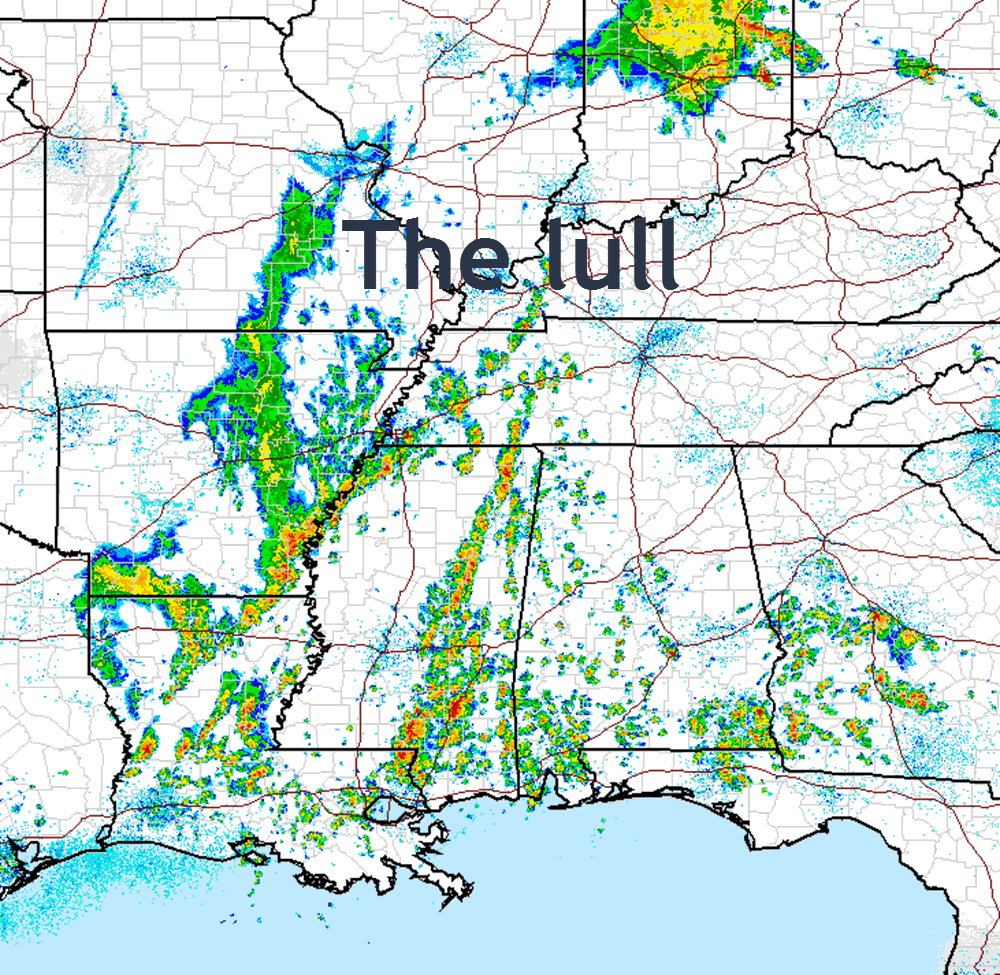
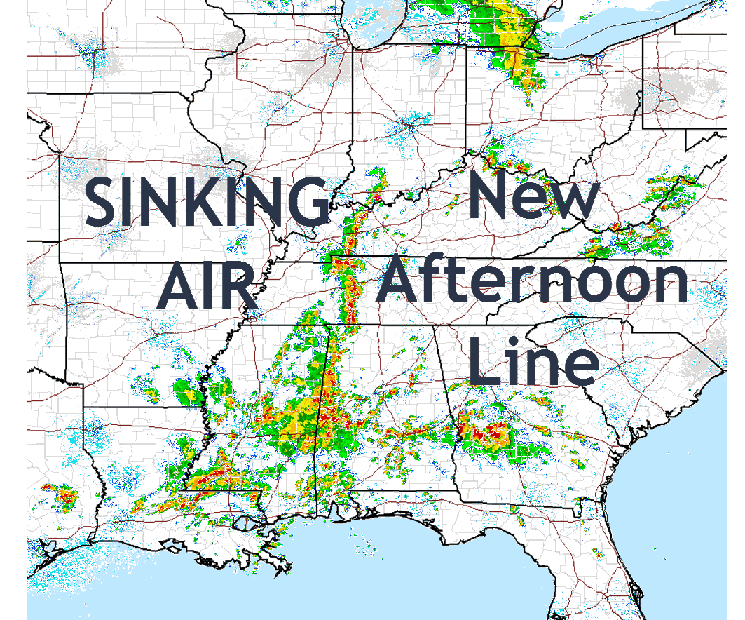
Here are the radar indicated rainfall totals from this event.
Click to enlarge.

Find me on Twitter
.

We have regional radars and local city radars – if a radar does not update then try another one. Occasional browsers need their cache cleared. You may also try restarting your browser. That usually fixes the problem. Occasionally we do have a radar go down. That is why I have duplicates. Thus, if one fails then try another one.
During the winter you can track snow and ice by clicking the winterize button on the local city view interactive radars.
If you have any problems then please send me an email beaudodson@usawx.com
Interactive Weather Radar Page. Choose the city nearest your location: Click this link—
National interactive radar: Click this link.
Local interactive city radars include St Louis, Mt Vernon, Evansville, Poplar Bluff, Cape Girardeau, Marion, Paducah, Hopkinsville, Memphis, Nashville, Dyersburg, and all of eastern Kentucky. These are interactive radars. Local city radars – click here
.

The official 6-10 day and 8-14 day temperature and precipitation outlook. Check the date stamp at the top of each image (so you understand the time frame).
.
The forecast maps below are issued by the Weather Prediction Center (NOAA)
.

.

.
The latest 8-14 day temperature and precipitation outlook. Note the dates are at the top of the image. These maps DO NOT tell you how high or low temperatures or precipitation will be. They simply give you the probability as to whether temperatures or precipitation will be above or below normal.
.


.
The Beau Dodson Weather APP is ready for Apple and Android users. The purpose of this app is for me to deliver your text messages instantly. ATT and Verizon have not always been reliable when it comes to speed. The app allows instant delivery.
Some of you have asked if you can keep receiving the texts on your phone and the app. The answer to that is, yes. The Android app will automatically allow that to happen. On the Apple app, however, you will need to go into your app and click settings. Make sure the green tab is OFF. Off means you will still receive the texts to your phone and the app. If you have any questions, then email me at beaudodson@usawx.com
The app is for text subscribers.
The direct download, for the Apple app, can be viewed here
https://itunes.apple.com/us/app/id1190136514
If you have not signed up for the texting service then you may do so at www.beaudodsonweather.com

The Android app is also ready.
Remember, the app’s are for www.weathertalk.com subscribers. The app allows your to receive the text messages faster than ATT and Verizon.
Here is the download link for the Android version Click Here

——————————————————–
If you have not signed up for the texts messages, then please do. Link www.beaudodsonweather.com
Your support helps with the following:

and


Who do you trust for your weather information and who holds them accountable?
I have studied weather in our region since the late 1970’s. I have 39 years of experience in observing our regions weather patterns. My degree is in Broadcast Meteorology and a Bachelor’s of Science.
My resume includes:
Member of the American Meteorological Society.
NOAA Weather-Ready Nation Ambassador.
Meteorologist for McCracken County Emergency Management. I served from 2005 through 2015.
Meteorologist for McCracken County Rescue. 2015 through current
I own and operate the Southern Illinois Weather Observatory.
I am the chief meteorologist for Weather Talk LLC. I am the owner of Weather Talk LLC.
I am also a business owner in western Kentucky.
Recipient of the Mark Trail Award, WPSD Six Who Make A Difference Award, Kentucky Colonel, and the Caesar J. Fiamma” Award from the American Red Cross.
In 2005 I helped open the largest American Cross shelter in U.S. history in Houston, Texas. I was deployed to help after Hurricane Katrina and Hurricane Rita. I was a shelter manager of one of the Houston, Texas shelter divisions.
In 2009 I was presented with the Kentucky Office of Highway Safety Award.
Recognized by the Kentucky House of Representatives for my service to the State of Kentucky leading up to several winter storms and severe weather outbreaks.
If you click on the image below you can read the Kentucky House of Representatives Resolution.

I am also President of the Shadow Angel Foundation which serves portions of western Kentucky and southern Illinois.
There is a lot of noise on the internet. A lot of weather maps are posted without explanation. Over time you should learn who to trust for your weather information.
My forecast philosophy is simple and straight forward.
- Communicate in simple terms
- To be as accurate as possible within a reasonable time frame before an event
- Interact with you on Twitter, Facebook, email, texts, and this blog
- Minimize the “hype” that you might see on some television stations or through other weather sources
- Push you towards utilizing wall-to-wall LOCAL TV coverage during severe weather events
Many of the graphics on this page are from www.weatherbell.com
WeatherBell is a great resource for weather model guidance.


You can sign up for my AWARE email by clicking here I typically send out AWARE emails before severe weather, winter storms, or other active weather situations. I do not email watches or warnings. The emails are a basic “heads up” concerning incoming weather conditions