Friday morning update

.

This forecast update covers far southern Illinois, far southeast Missouri, and far western Kentucky. See the coverage map on the right side of the blog
.
Thursday Night Forecast Details:
Forecast: Partly cloudy. A 40% for storms before 12 am. Becoming cloudy. A 60% to 70% for storms after 2 am. Some storms could produce high winds and frequent lightning. Heavy downpours. Best chances would be southeast Missouri and southern Illinois. Confidence in rain coverage over Kentucky and Tennessee is lower.
Temperatures: MO ~ 66 to 74 IL ~ 64 to 72 KY ~ 66 to 72 TN ~ 68 to 74
Winds: South and southwest becoming south and southeast at 6 to 12 mph with gusts to 20 mph.
My confidence in the forecast verifying: Medium. Some adjustments are possible.
What impacts are anticipated from the weather? Wet roadways. Lightning. Nickel size hail possible. The most intense storms early Friday morning could produce strong winds, as well. A non-zero severe weather risk.
Is severe weather expected? A few storms could be quite intense late tonight over southeast Missouri and perhaps southwest Illinois. A small risk for severe weather. High winds and hail would be the primary concern. Elsewhere, the risk for severe weather is low.
The NWS defines severe weather as 58 mph winds or great, 1″ hail or larger, and/or tornadoes
What is the chance of precipitation? MO ~ 40% before 11 pm and 70% after 2 am IL ~ 40% before 11 pm and then 70% after 2 am KY ~ 40% to 50% TN ~ 40% to 50%
Coverage of precipitation: Scattered early. Becoming numerous late.
Should I cancel my outdoor plans? No, but monitor radars. There will be some storms around the area.
.
May 19, 2017
Friday Forecast Details
Forecast: Party to mostly cloudy. Spotty morning storms. Storms may become more numerous during the late morning and afternoon hours. A few storms could produce heavy rain, frequent lightning, high winds, and even hail. The tornado risk is low.
Temperatures: MO ~ 80 to 85 IL 80 to 85 KY 80 to 86 TN 82 to 86
Winds: South and southeast at 6 to 12 mph with gusts to 18 mph. Winds becoming more southerly through the day.
What impacts are anticipated from the weather? Wet roadways and lightning. Intense storms possible with gusty winds and perhaps hail.
My confidence in the forecast verifying: Medium. Some adjustments are possible.
Is severe weather expected? Monitor updates. I can’t rule out a few severe storms.
The NWS defines severe weather as 58 mph winds or great, 1″ hail or larger, and/or tornadoes
What is the chance of precipitation? MO ~ 50% IL ~ 50% KY ~ 40% TN ~ 40%
Coverage of precipitation: Scattered to perhaps numerous. Should I cancel my outdoor plans? No, but monitor radars. There will be showers and storms in the area. Perhaps greatest coverage will be across southeast Missouri and southern Illinois between 2 am and 10 am.
.
Friday Night Forecast Details:
Forecast: Partly cloudy. A 40% to 50% for thunderstorms before 12 am. An increasing chance of new storms arriving from the west/southwest during the wee early morning hours.
Temperatures: MO ~ 65 to 70 IL ~ 65 to 70 KY ~ 65 to 70 TN ~ 65 to 70
Winds: South and southeast at 5 to 10 mph with gusts to 15 mph
My confidence in the forecast verifying: Medium. Some adjustments are possible.
What impacts are anticipated from the weather? Wet roadways. Lightning. A few intense storms possible.
Is severe weather expected? Monitor updates. I can’t rule out a few severe storms.
The NWS defines severe weather as 58 mph winds or great, 1″ hail or larger, and/or tornadoes
What is the chance of precipitation? MO ~ 40% IL ~ 40% KY ~ 50% TN ~ 50% (increasing chances late)
Coverage of precipitation: Scattered
Should I cancel my outdoor plans? No, but monitor radars. There will be at least some risk for precipitation.
.
May 20, 2017
Saturday Forecast Details
Forecast: Partly cloudy. A 40% for morning thunderstorms. A 60% chance for afternoon showers and storms. Storms should spread west to east on Saturday. The cold front may approach southeast Missouri late Saturday afternoon and evening. A line of storms along the front. This will first begin over southeast Missouri and spread eastward. That would be on top of whatever other activity develops Saturday morning.
Temperatures: MO ~ 84 to 86 IL 84 to 86 KY 84 to 86 TN 84 to 86
Winds: South and southeast at 6 to 12 mph with gusts to 18 mph
What impacts are anticipated from the weather? Lightning. Wet roadways
My confidence in the forecast verifying: Medium. Some adjustments are possible.
Is severe weather expected? Monitor updates
The NWS defines severe weather as 58 mph winds or great, 1″ hail or larger, and/or tornadoes
What is the chance of precipitation? MO ~ 60% IL ~ 60% KY ~ 60% TN ~ 50%
Coverage of precipitation: Scattered to perhaps numerous. Increasing coverage during the afternoon and evening hours.
Should I cancel my outdoor plans? No, but have a plan B and monitor the radars.
.
Saturday Night Forecast Details:
Forecast: Mostly cloudy. An 80% for showers and thunderstorms.
Temperatures: MO ~ 60 to 65 IL ~ 60 to 65 KY ~ 60 to 65 TN ~ 62 to 66
Winds: South and southwest winds at 5 to 10 mph with gusts to 20 mph. Winds may shift more southwest and west after 2 am.
My confidence in the forecast verifying: High. This forecast should verify.
What impacts are anticipated from the weather? Wet roadways. Lightning. A few intense storms possible.
Is severe weather expected? Monitor updates. Perhaps a few intense storms with the front.
The NWS defines severe weather as 58 mph winds or great, 1″ hail or larger, and/or tornadoes
What is the chance of precipitation? MO ~ 80% IL ~ 80% KY ~ 80% TN ~ 80%
Coverage of precipitation: Becoming numerous
Should I cancel my outdoor plans? Have a plan B. Rain is possible. Monitor radars.
.
May 21, 2017
Sunday Forecast Details
Forecast: A 60% chance for morning showers and thunderstorms. A 40% chance for afternoon showers and a slight chance for thunderstorms. Rain will end west to east.
Temperatures: MO ~ 72 to 76 IL 72 to 76 KY 72 to 78 TN 74 to 78
Winds: Winds becoming west and northwest at 7 to 14 mph with gusts to 18 mph.
What impacts are anticipated from the weather? Wet roadways and lightning
My confidence in the forecast verifying: Medium. Some adjustments are possible.
Is severe weather expected? Unlikely, but monitor updates. Storms along the cold front could be intense.
The NWS defines severe weather as 58 mph winds or great, 1″ hail or larger, and/or tornadoes
What is the chance of precipitation? MO ~ 60% IL ~ 60% KY ~ 60% TN ~ 60%
Coverage of precipitation: Perhaps numerous during the morning hours. Scattered afternoon.
Should I cancel my outdoor plans? Have a plan B. Rain is possible. Monitor radars.
.
Sunday Night Forecast Details:
Forecast: Any remaining showers will end. Partly cloudy and cooler. Patchy fog.
Temperatures: MO ~ 52 to 58 IL ~ 52 to 58 KY ~ 55 to 60 TN ~ 55 to 60
Winds: Northwest winds at 5 to 10 mph.
My confidence in the forecast verifying: High. This forecast should verify.
What impacts are anticipated from the weather? Patchy fog possible.
Is severe weather expected? No.
The NWS defines severe weather as 58 mph winds or great, 1″ hail or larger, and/or tornadoes
What is the chance of precipitation? MO ~ 10% IL ~ 10% KY ~ 20% TN ~ 20%
Coverage of precipitation: Ending.
Should I cancel my outdoor plans? No.
.
May 22, 2017
Monday Forecast Details
Forecast: Partly cloudy.
Temperatures: MO ~ 74 to 78 IL 74 to 78 KY 74 to 78 TN 74 to 78
Winds: West and northwest winds at 5 to 10 mph with gusts to 15 mph
What impacts are anticipated from the weather? None
My confidence in the forecast verifying: Medium. Some adjustments are possible.
Is severe weather expected? No
The NWS defines severe weather as 58 mph winds or great, 1″ hail or larger, and/or tornadoes
What is the chance of precipitation? MO ~ 0% IL ~ 0% KY ~ 0% TN ~ 0%
Coverage of precipitation: None
Should I cancel my outdoor plans? No
.
Monday Night Forecast Details:
Forecast: Increasing clouds. A 40% for showers and thunderstorms. Perhaps mainly over southeast Missouri late.
Temperatures: MO ~ 54 to 58 IL ~ 54 to 58 KY ~ 54 to 58 TN ~ 54 to 58
Winds: Variable at 5 to 10 mph
My confidence in the forecast verifying: Low. Significant adjustments are possible.
What impacts are anticipated from the weather? Wet roadways. Lightning.
Is severe weather expected? No
The NWS defines severe weather as 58 mph winds or great, 1″ hail or larger, and/or tornadoes
What is the chance of precipitation? MO ~ 50% IL ~ 40% KY ~ 40% TN ~ 30%
Coverage of precipitation: Scattered
Should I cancel my outdoor plans? No
.
May 23, 2017
Tuesday Forecast Details
Forecast: Partly sunny. A chance for showers and thunderstorms.
Temperatures: MO ~ 74 to 78 IL 74 to 78 KY 74 to 78 TN 74 to 78
Winds: Variable winds at 5 to 10 mph.
What impacts are anticipated from the weather? Wet roadways. Lightning.
My confidence in the forecast verifying: Medium. Some adjustments are possible.
Is severe weather expected? No
The NWS defines severe weather as 58 mph winds or great, 1″ hail or larger, and/or tornadoes
What is the chance of precipitation? MO ~ 40% IL ~ 40% KY ~ 40% TN ~ 40%
Coverage of precipitation: Scattered.
Should I cancel my outdoor plans? Monitor updates.
.
Tuesday Night Forecast Details:
Forecast: Cloudy. A chance for showers and thunderstorms.
Temperatures: MO ~ 60 to 65 IL ~ 60 to 65 KY ~ 60 to 65 TN ~ 60 to 65
Winds: South 5 to 10 mph with gusts to 15 mph.
My confidence in the forecast verifying: Medium. Some adjustments are possible.
What impacts are anticipated from the weather? Wet roadways. Lightning.
Is severe weather expected? Unlikely, but monitor updates.
The NWS defines severe weather as 58 mph winds or great, 1″ hail or larger, and/or tornadoes
What is the chance of precipitation? MO ~ 30% IL ~ 30% KY ~ 30% TN ~ 30%
Coverage of precipitation: Scattered
Should I cancel my outdoor plans? Monitor updates.
.
May 24, 2017
Wednesday Forecast Details
Forecast: Partly cloudy. A chance for a few showers.
Temperatures: MO ~ 70 to 75 IL 70 to 75 KY 70 to 75 TN 70 to 75
Winds: Northwest at 10 mph.
What impacts are anticipated from the weather? Wet roadways.
My confidence in the forecast verifying: Low. Significant adjustments are possible.
Is severe weather expected? No
The NWS defines severe weather as 58 mph winds or great, 1″ hail or larger, and/or tornadoes
What is the chance of precipitation? MO ~ 30% IL ~ 30% KY ~ 30% TN ~ 30%
Coverage of precipitation: Scattered
Should I cancel my outdoor plans? Monitor updated forecasts
.
Wednesday Night Forecast Details:
Forecast: Partly cloudy. A chance for showers.
Temperatures: MO ~ 50 to 55 IL ~ 50 to 55 KY ~ 50 to 55 TN ~ 50 to 55
Winds: Northwest at 5 mph.
My confidence in the forecast verifying: Low. Significant adjustments are possible.
What impacts are anticipated from the weather? Wet roadways.
Is severe weather expected? No
The NWS defines severe weather as 58 mph winds or great, 1″ hail or larger, and/or tornadoes
What is the chance of precipitation? MO ~ 30% IL ~ 30% KY ~ 30% TN ~ 30%
Coverage of precipitation: Scattered
Should I cancel my outdoor plans? Monitor updates.
.
.
Don’t forget to check out the Southern Illinois Weather Observatory web-site for weather maps, tower cams, scanner feeds, radars, and much more! Click here
.

An explanation of what is happening in the atmosphere over the coming day
.

A severe thunderstorm is defined as a storm that produces quarter size hail or larger, 58 mph winds or greater, and/or a tornado. That is the official National Weather Service definition of a severe thunderstorm.
Thursday night through Sunday: Thunderstorm chances will increase on Thursday night into Sunday morning.
Perhaps peak times for thunderstorms will be Friday morning and then Saturday afternoon and night.
Confidence is low when it comes to the exact timing of each round of thunderstorms. A series of upper level disturbances will push through the region. A
A few storms could become severe. There is one risk on Friday and another Saturday afternoon and night.
Lightning will be a concern for outdoor activities. Locally heavy rain will also be possible. Slow moving storms can drop a quick one inch or rain (or more).
Monitor updates.
Next Monday through Wednesday: Dry Monday. Shower and thunderstorm chances may return as early as Monday night and Tuesday. The severe weather risk appears low. Monitor updates, as always.
.
.
Weather Analysis for the coming week:
The main idea to take from this forecast is to have a plan B if you have outdoor events. Have a plan in mind and then enjoy the weekend. Throw an umbrella and a rain jacket in the car. Check your radars from time to time. I would not cancel any events. Have the plan B ready to go.
A series of upper level disturbances will keep rain chances alive into Sunday morning. The main cold front won’t arrive until Saturday afternoon and night. The front will move through the region late Saturday night into Sunday morning. Rain will come to an end once the front sweeps eastward. Timing of the front is key to rain chances.
It continues to be tricky forecasting exactly when and where rain will fall over the coming days. On Wednesday we had a couple of bands of showers and storms form during the afternoon and evening hours. Locally heavy rain, pea size hail, and frequent lightning were reported with the heaviest cells. No severe weather was reported.
We also had blowing sand and dust over the Missouri Bootheel and portions of southeast Missouri. Sadly, one person was killed and three others injured when a tree fell on them. These winds were non-thunderstorm winds. They were gradient winds. Gradient winds are caused by a tightening pressure gradient.
Thursday night through Friday night will deliver much of the same. Scattered showers and thunderstorms. Humid and warm.
Some of the storms could be intense on Friday. Isolated severe storms possible.
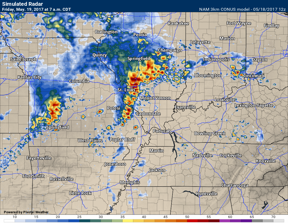
Guidance shows a line of storms over parts of southeast Missouri late tonight into early Friday morning. Future-cast radar from 3K NAM shows this nicely.
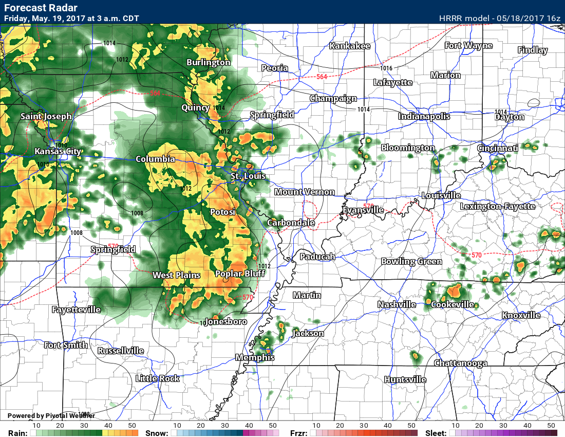
Other data shows the line further south and impacting a large portion of our area.
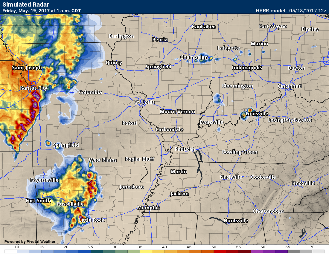
This is the 1 am future-cast radar (this is the HRRR model)
This is the 3K NAM model for 7 am
Another data set shows this for 3 am on Friday
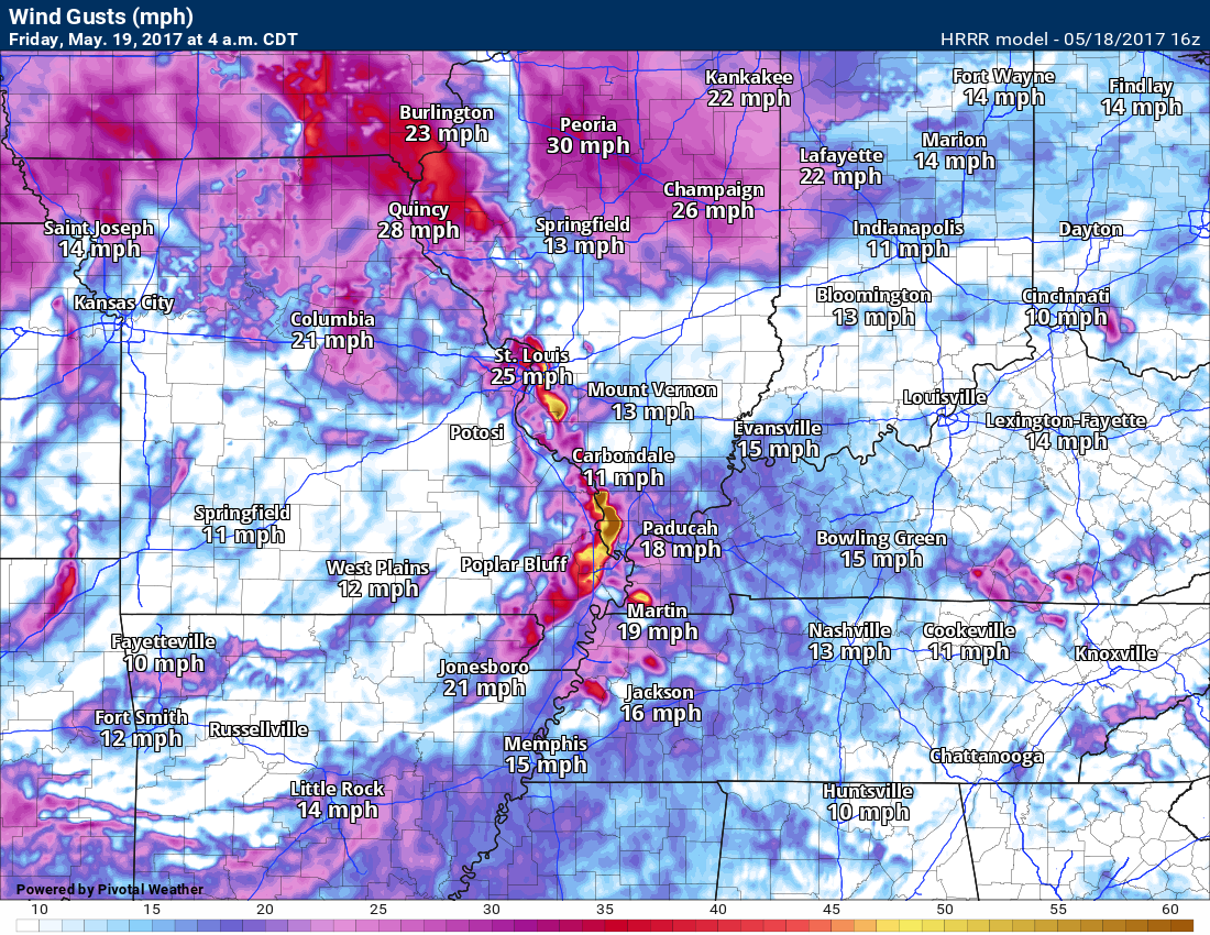
Interesting the HRRR model shows high winds with the storms early in the morning. You can see it there at 4 am over southern Illinois.
Saturday into Sunday morning will deliver the greatest rain chances. You can expect a 40% chance on Saturday morning, increasing to a 50% to 60% Saturday afternoon, and 70% to 80% on Saturday night and early Sunday morning. At this time, it appears chances will decrease on Sunday afternoon and evening.
3K NAM shows a couple of lines of storms Saturday afternoon and evening.
4 PM Future-cast radar for Saturday. This won’t be exact. Models are not that great. Take the general idea from this future-cast radar image.
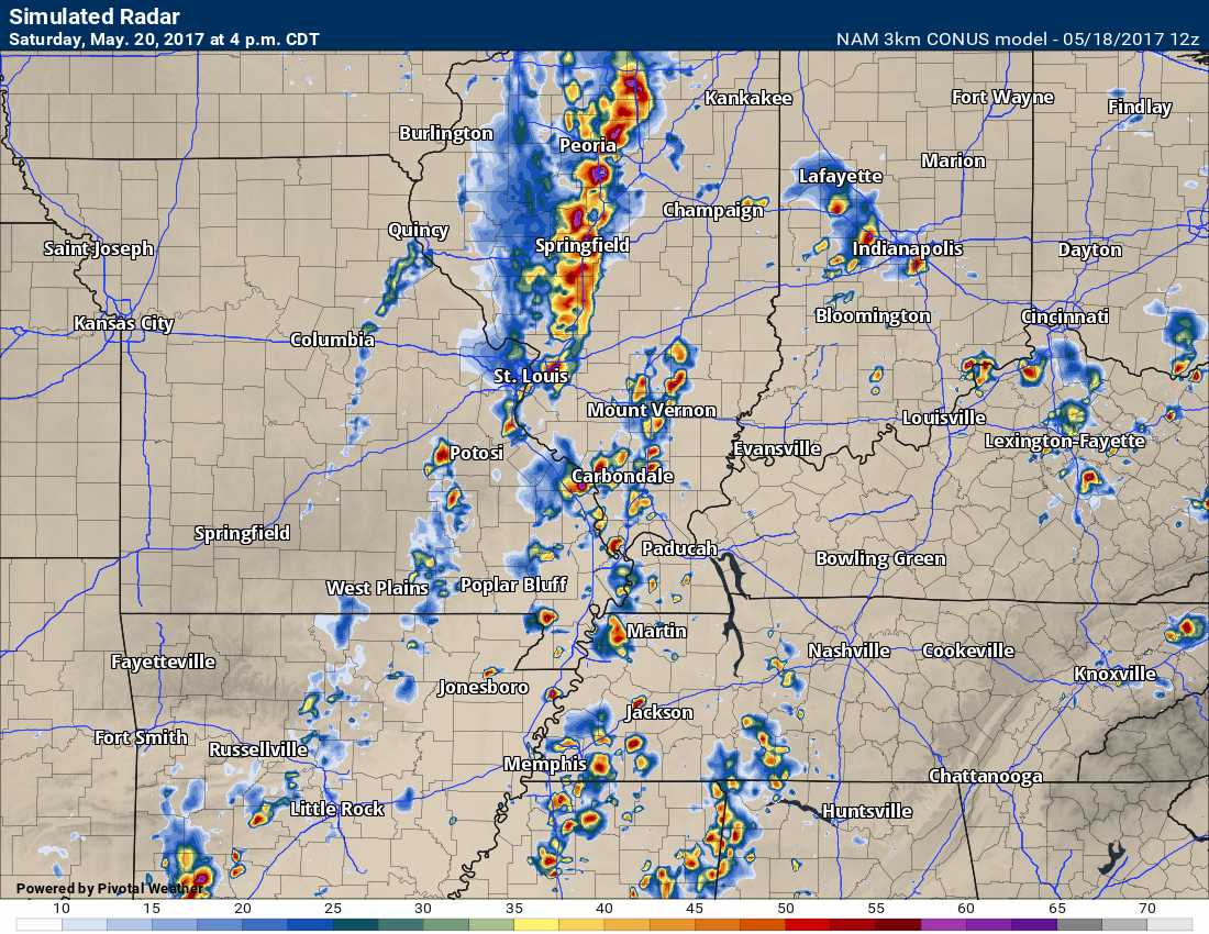
7 pm future-cast radar for Saturday

With all of the above said, if the front slows or speeds up a bit then rain chances will need to be increased or decreased. Again, the best chance of rain is right along and ahead of the cold front. Thus, the timing of the front is what is important in this forecast.
Organized severe weather is unlikely. A few isolated severe thunderstorms are possible. Hail and gusty winds would be the main concern.
The bigger concern will be lightning and heavy downpours. I know there are a lot of activities this weekend.
I will need to monitor the severe weather risk right along the cold front. There will be at least some opportunity for heavier storms with the front. There are several ingredients missing for widespread severe weather. With that said, I would not be surprised if a few storms became severe right along the frontal boundary.
Sunday night into Monday should be dry.
Shower and thunderstorm chances will increase again on Monday night and Tuesday. The greatest chance on Monday night would probably be over southeast Missouri and southwest Illinois. The rain chances will spread east with time.
We may have to deal with rain chances into Tuesday night and Wednesday.
The GFS shows several rain chances next week (see graphics below). One models opinion.
Cooler temperatures are forecast next week. Below normal temperatures are likely Monday through Sunday. Some days will have well below normal temperatures.
I am monitoring the potential for a northwest flow pattern developing. If a northwest flow pattern develops then a series of MCS’s will track from the northwest towards the southeast. The placement of the jet stream will be key to where these thunderstorm complexes track. MCS’s are large thunderstorm complexes that can produce heavy rain and occasionally severe weather.
We don’t need more rain.
Let me show you the GFS 24 hour rainfall maps. Now, keep in mind, this is one model’s opinion on rainfall totals next week. Models are all over the place with each little system that moves through the fast jet stream flow. That means changeable forecasts are possible (if not likely).
This first graphic represents rainfall totals from 7 am Tuesday through 7 am on Wednesday

This next image is for 7 am on Wednesday through 7 am Thursday

This next graphic is for 7 am on Thursday through 7 am on Friday
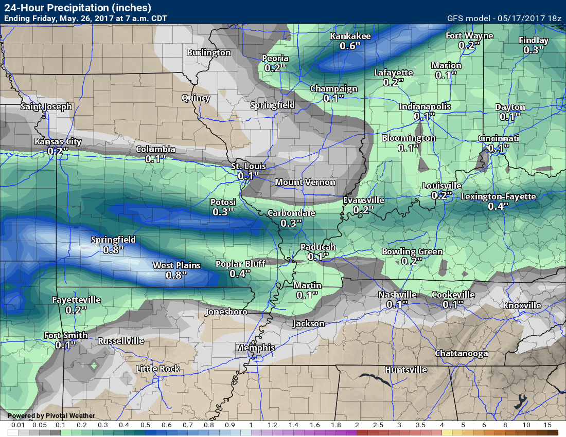
This next graphic is for 7 am Friday through 7 am Saturday. Again, this is one model’s opinion.

Obviously the GFS believes it is going to be an active/wet week.
Let’s take a look at temperatures for the upcoming week.
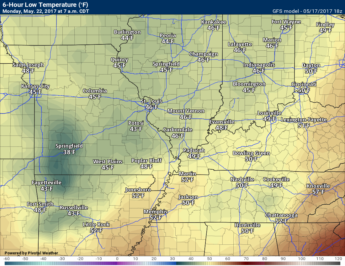
This first graphic is for Sunday morning at 7 am. Can you find the cold front?

This next graphic, from the GFS model, is for 7 am on Monday
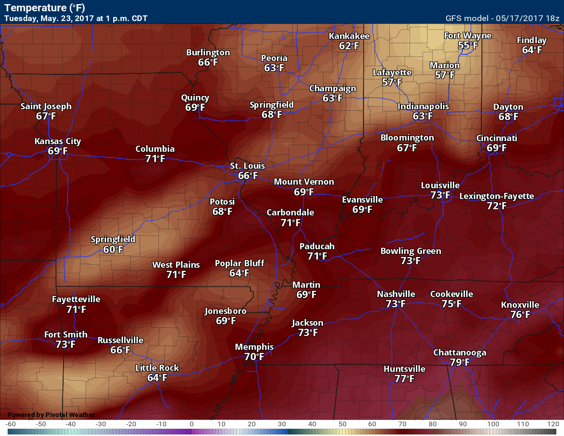
This next graphic is for 1 pm on Tuesday
This next graphic is for 1 pm on Wednesday. The cooler temperatures are showing up because of clouds and rain.
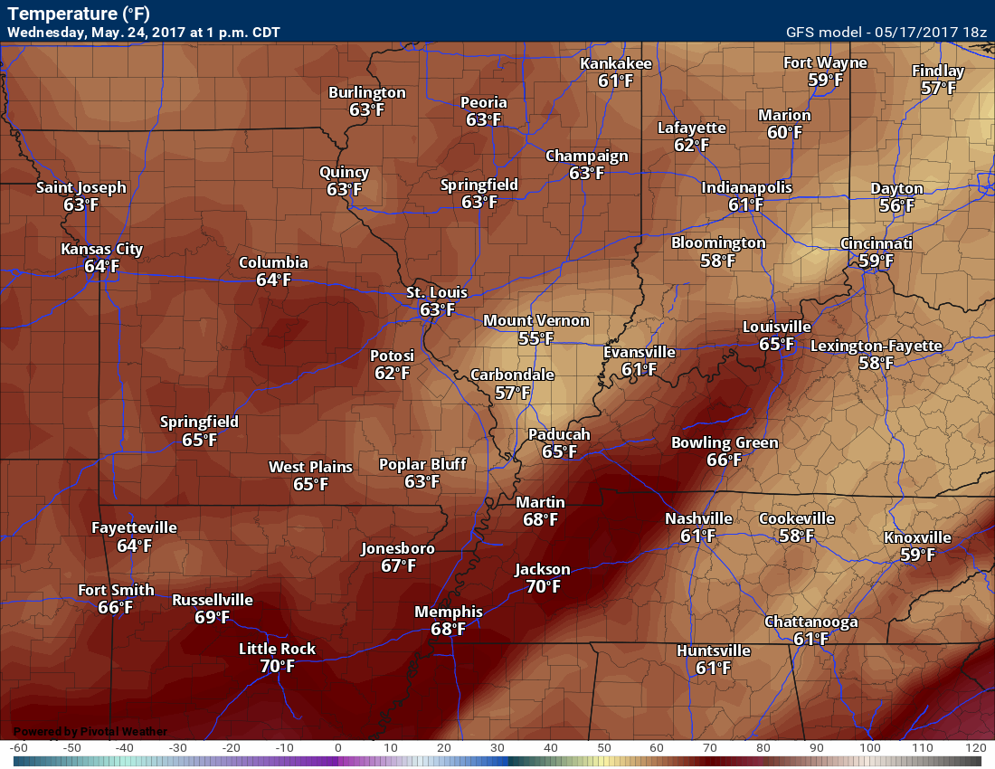
This next graphic is for 1 pm on Thursday

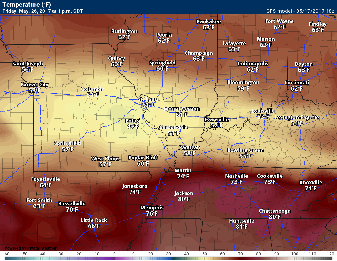
This next graphics is for 1 pm on Friday
Again, the wide range of temperatures is because of clouds and precipitation.

Find me on Twitter
.

We have regional radars and local city radars – if a radar does not update then try another one. Occasional browsers need their cache cleared. You may also try restarting your browser. That usually fixes the problem. Occasionally we do have a radar go down. That is why I have duplicates. Thus, if one fails then try another one.
During the winter you can track snow and ice by clicking the winterize button on the local city view interactive radars.
If you have any problems then please send me an email beaudodson@usawx.com
Interactive Weather Radar Page. Choose the city nearest your location: Click this link—
National interactive radar: Click this link.
Local interactive city radars include St Louis, Mt Vernon, Evansville, Poplar Bluff, Cape Girardeau, Marion, Paducah, Hopkinsville, Memphis, Nashville, Dyersburg, and all of eastern Kentucky. These are interactive radars. Local city radars – click here
.

The official 6-10 day and 8-14 day temperature and precipitation outlook. Check the date stamp at the top of each image (so you understand the time frame).
.
The forecast maps below are issued by the Weather Prediction Center (NOAA)
.

.

.
The latest 8-14 day temperature and precipitation outlook. Note the dates are at the top of the image. These maps DO NOT tell you how high or low temperatures or precipitation will be. They simply give you the probability as to whether temperatures or precipitation will be above or below normal.
.


.
The Beau Dodson Weather APP is ready for Apple and Android users. The purpose of this app is for me to deliver your text messages instantly. ATT and Verizon have not always been reliable when it comes to speed. The app allows instant delivery.
Some of you have asked if you can keep receiving the texts on your phone and the app. The answer to that is, yes. The Android app will automatically allow that to happen. On the Apple app, however, you will need to go into your app and click settings. Make sure the green tab is OFF. Off means you will still receive the texts to your phone and the app. If you have any questions, then email me at beaudodson@usawx.com
The app is for text subscribers.
The direct download, for the Apple app, can be viewed here
https://itunes.apple.com/us/app/id1190136514
If you have not signed up for the texting service then you may do so at www.beaudodsonweather.com

The Android app is also ready.
Remember, the app’s are for www.weathertalk.com subscribers. The app allows your to receive the text messages faster than ATT and Verizon.
Here is the download link for the Android version Click Here

——————————————————–
If you have not signed up for the texts messages, then please do. Link www.beaudodsonweather.com
Your support helps with the following:

and


Who do you trust for your weather information and who holds them accountable?
I have studied weather in our region since the late 1970’s. I have 39 years of experience in observing our regions weather patterns. My degree is in Broadcast Meteorology and a Bachelor’s of Science.
My resume includes:
Member of the American Meteorological Society.
NOAA Weather-Ready Nation Ambassador.
Meteorologist for McCracken County Emergency Management. I served from 2005 through 2015.
Meteorologist for McCracken County Rescue. 2015 through current
I own and operate the Southern Illinois Weather Observatory.
I am the chief meteorologist for Weather Talk LLC. I am the owner of Weather Talk LLC.
I am also a business owner in western Kentucky.
Recipient of the Mark Trail Award, WPSD Six Who Make A Difference Award, Kentucky Colonel, and the Caesar J. Fiamma” Award from the American Red Cross.
In 2005 I helped open the largest American Cross shelter in U.S. history in Houston, Texas. I was deployed to help after Hurricane Katrina and Hurricane Rita. I was a shelter manager of one of the Houston, Texas shelter divisions.
In 2009 I was presented with the Kentucky Office of Highway Safety Award.
Recognized by the Kentucky House of Representatives for my service to the State of Kentucky leading up to several winter storms and severe weather outbreaks.
If you click on the image below you can read the Kentucky House of Representatives Resolution.

I am also President of the Shadow Angel Foundation which serves portions of western Kentucky and southern Illinois.
There is a lot of noise on the internet. A lot of weather maps are posted without explanation. Over time you should learn who to trust for your weather information.
My forecast philosophy is simple and straight forward.
- Communicate in simple terms
- To be as accurate as possible within a reasonable time frame before an event
- Interact with you on Twitter, Facebook, email, texts, and this blog
- Minimize the “hype” that you might see on some television stations or through other weather sources
- Push you towards utilizing wall-to-wall LOCAL TV coverage during severe weather events
Many of the graphics on this page are from www.weatherbell.com
WeatherBell is a great resource for weather model guidance.


You can sign up for my AWARE email by clicking here I typically send out AWARE emails before severe weather, winter storms, or other active weather situations. I do not email watches or warnings. The emails are a basic “heads up” concerning incoming weather conditions