We have some great sponsors for the Weather Talk Blog. Please let our sponsors know that you appreciate their support for the Weather Talk Blog.
Milner and Orr Funeral Home and Cremation Services located in Paducah, Kentucky and three other western Kentucky towns – at Milner and Orr they believe in families helping families. You can find Milner and Orr on Facebook, as well.
![]()
.

For all of your families eye care needs. Visit their web-site here. Or, you can also visit their Facebook page.
.

Best at Enabling Body Shop Profitability since 1996. Located In Paducah Kentucky and Evansville Indiana; serving all customers in between. They provide Customer Service, along with all the tools necessary for body shops to remain educated and competitive. Click the logo above for their main web-site. You can find McClintock Preferred Finishes on Facebook, as well

Expressway Carwash and Express Lube are a locally owned and operated full service Carwash and Lube established in 1987. If you haven’t already, be sure to make Expressway your one stop shop, with our carwash, lube and deli. For hours of operation and pricing visit www.expresswashlube.com or Expressway Carwash on Facebook.

Heath Health Foods is a locally owned and operated retail health and wellness store. Since opening in February 2006; the store has continued to grow as a ministry with an expanding inventory which also offers wellness appointments and services along with educational opportunities. Visit their web-site here. And. visit Heath Health Foods on Facebook!

I will keep this page updated until the event is over. If this page becomes too long then I will start a fresh page.
Links:
Facebook updates: Beau Dodson Weather
Live Feed for the texting service: Click here.
Beau on Twitter: @Beaudodson
NWS Watches and warnings
4 PM Update
End coverage here. Rivers will continue to rise over the coming week. Some showers/storms possible into Sunday. Coverage should be less than the last couple of days.
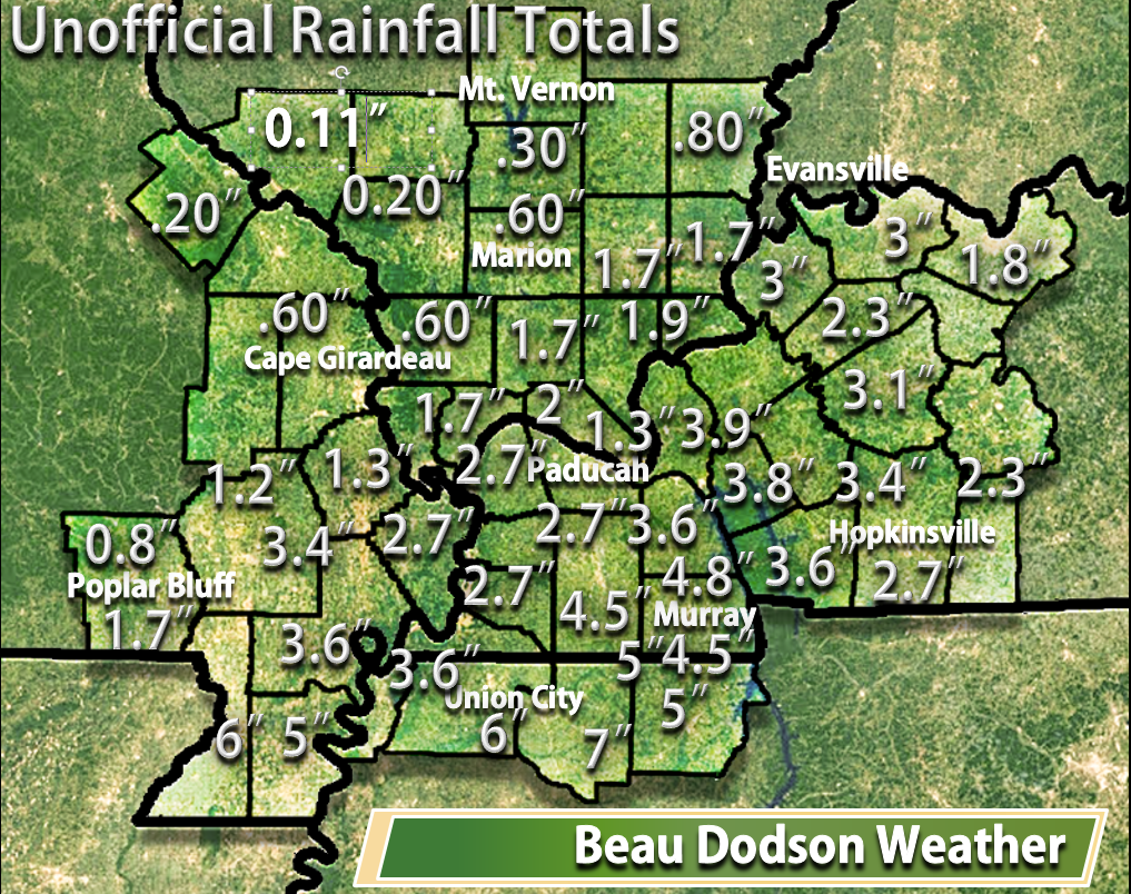
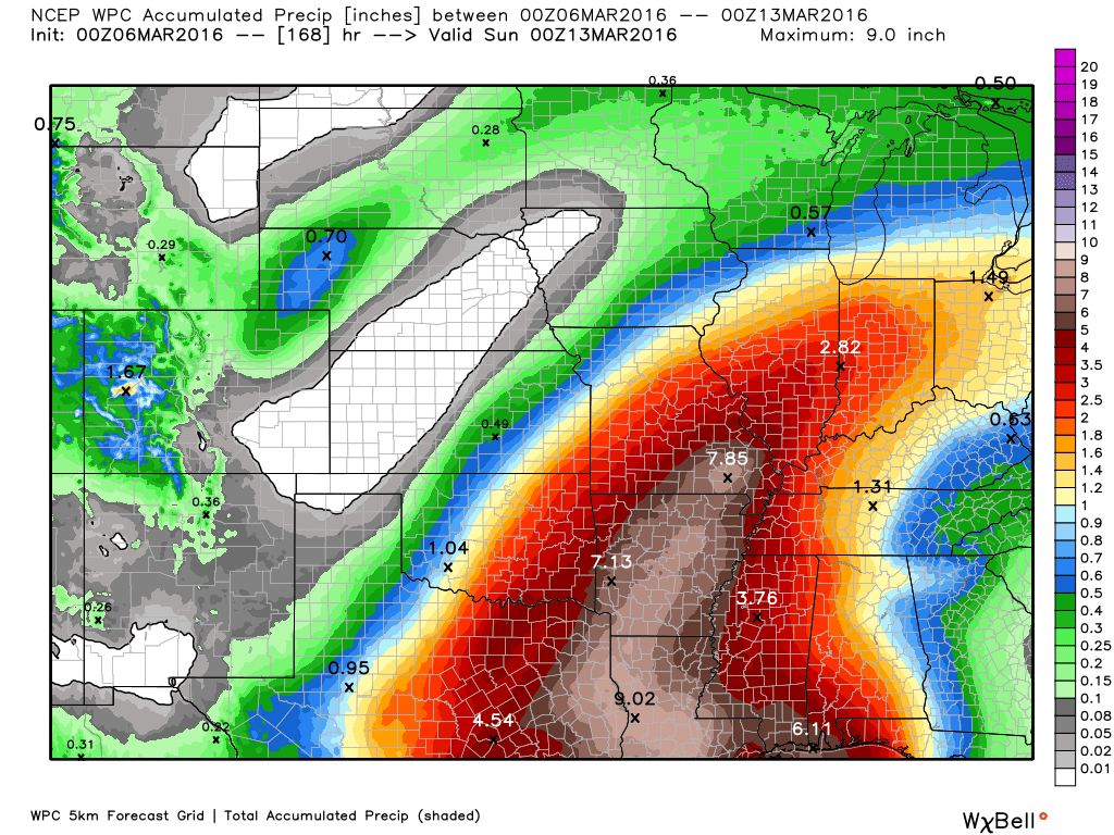
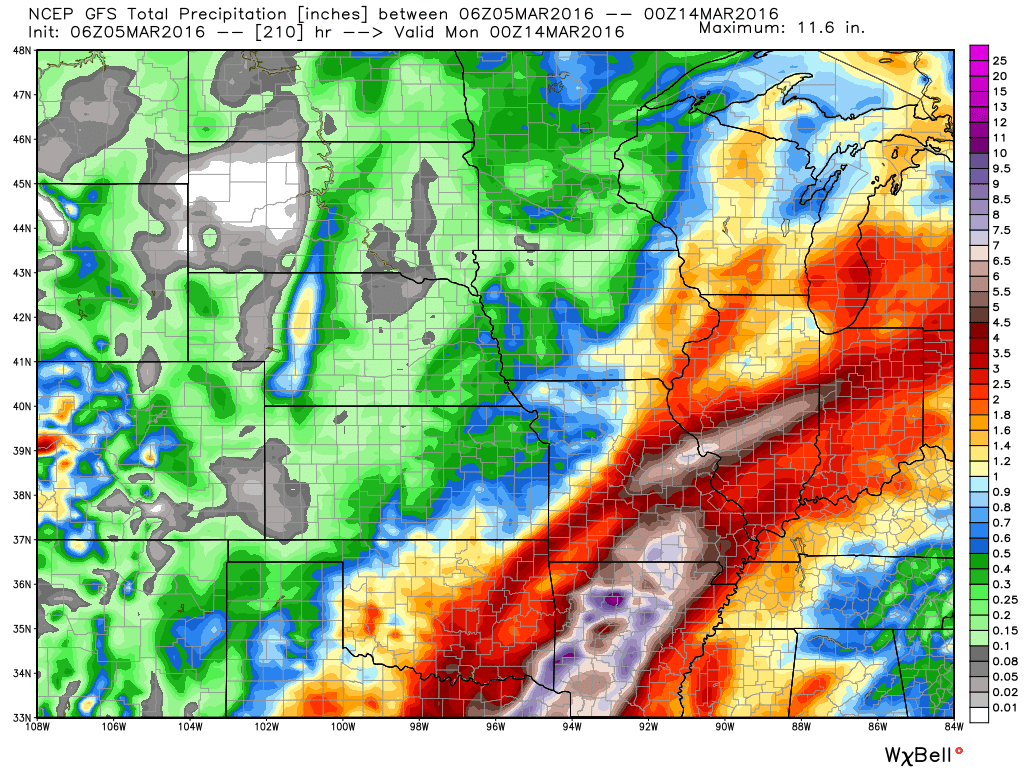
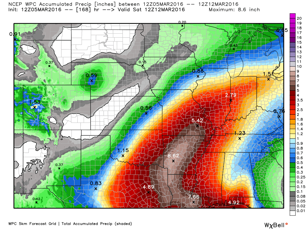
Here are the latest radar estimated rainfall totals. Widespread 1-4″ rain event. Pockets of 4-7″. Our northern and northwest counties did not receive much rain at all. Quite amazing from what everyone was thinking a few days ago. Of course the forecast caught up to the changes yesterday, but still amazing.
8 AM Update
Morning Facebook update. https://wtalk.co/HAFGQLZV
Thursday: Very heavy rains fell over a large chunk of the region last night. A widespread 1.5 to 3.5 rain event. Pockets of 3.5″-6″ were reported. The heaviest totals fell over the Missouri Bootheel into parts of northwest Tennessee and western Kentucky.
Numerous flash flood warnings were issued last night. Many roads flooded and some evacuations occurred.
Rain continues this morning over much of the region. The heaviest rain extended from south central Kentucky into western Tennessee.
Training is occurring over parts of western Kentucky and Tennessee. Heavy rain moving over the same areas. The axis of the heaviest rain is a bit east of last nights event.
Looking at radar and satellite data one can see that this rain extends all the way into Mexico.
Rain will continue into this afternoon. Another round of heavy rain is likely later this morning into the afternoon hours. This will be coming out of Arkansas. At this time it appears that the heaviest totals will fall over portions of western Kentucky into western Tennessee and perhaps the Missouri Bootheel.
Another 1-3″ of rain will be possible. Locally higher amounts. This will aggravate flooding problems.
Areas further north and west will have periods of showers. But, not as heavy.
Scattered showers and thunderstorms will be possible Friday into Sunday. Activity is not forecast to be as widespread as what has occurred over the past 24 hours.
Radars are up and running
http://weatherobservatory.com/weather-radar.htm
8 PM Update – Flood event is underway
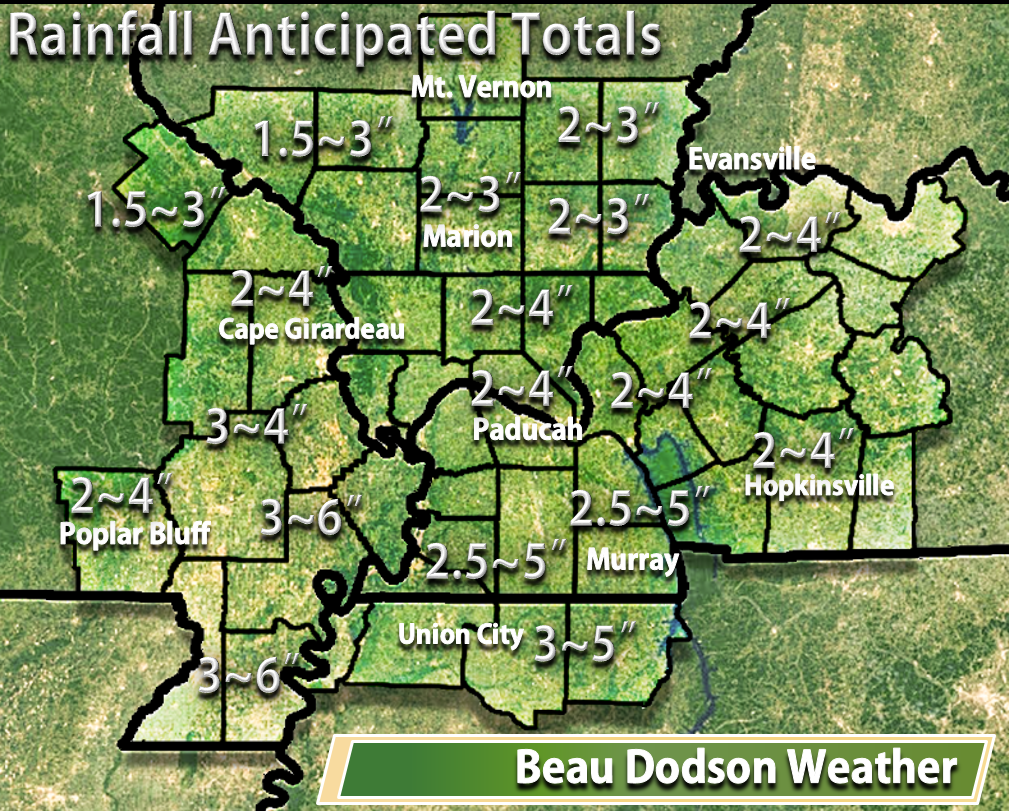
Additional heavy rain is likely tomorrow morning into the afternoon hours. Data indicates an additional 1-3″ of rain with pockets of greater than 3″ across parts of far southeast Missouri, far southern Illinois, Kentucky, and Tennessee. Keep in mind, everything shifted south and east in forecasts earlier today.
Flash flood warnings continue tonight for portions of the area. And, additional warnings are possible later tonight into tomorrow.
3 PM Update – Flood event is underway
Wednesday afternoon/evening update: Guidance continues to shift eastward with heavy rain.
Flash flood event possible tonight into Thursday over portions of the area. For the sake of yourself and first responders, please avoid flooded roadways.
Confidence in the forecast: Medium
Confidence in the placement of the heaviest rain band is low to medium
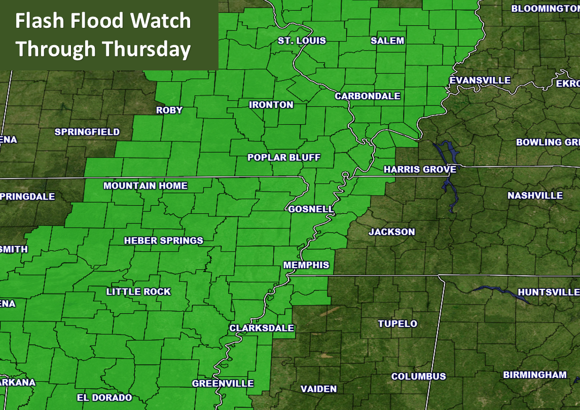
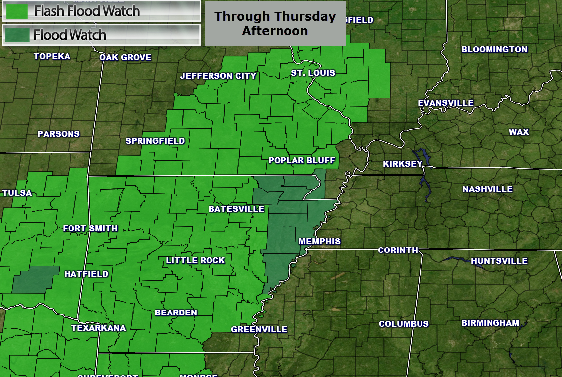
Flash flood watch covers much of the area. See graphics in the comments section. More counties may be added to the watch overnight.
Remember, weather is not static. Weather is fluid. Forecasts normally evolve as an event draws closer. This one will be no different.
Rain is developing along a boundary that extends from our region towards the Gulf of Mexico. The rain has become more organized and heavier over the past six hours. And, this should continue.
Very heavy rain is possible later tonight into Thursday across our region.
Latest guidance is painting a widespread 2″-3″ rain event with pockets of 3″-6″.
Over the past 48 hours the heaviest rain band has continue to shift eastward. At one time the heaviest rain was expected to fall over southeast Missouri and southwest Illinois. But, it appears some of the big totals could impact much of southern Illinois, western Kentucky, and western Tennessee. Thus, the flash flood watch was extended further east.
The biggest concern over the next 48-72 hours will be the exact placement of the heaviest rain bands.
Extremely difficult forecast when it comes to rainfall totals. There will be a wide range of totals over our area. Some areas will pick up 1″-2″ and other areas will pick up more than 4″ of rain.
Some flash flooding is possible. A few days ago this looked to be mostly an overland and river flood event. That has changed. Now it appears to be both.
Remember, a flash flood is a flood that occurs more rapidly because of heavy rain. A flood, by definition, has more to do with a moderate rain event occurring over an extended period of time.
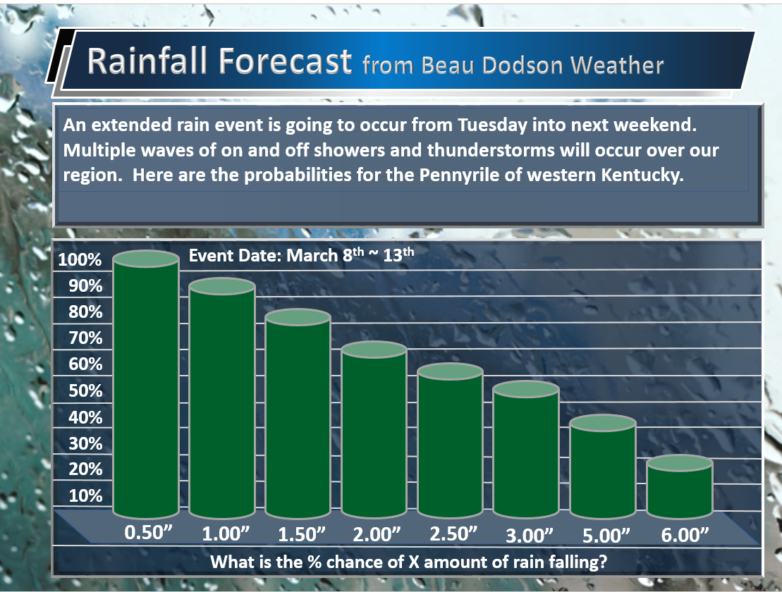
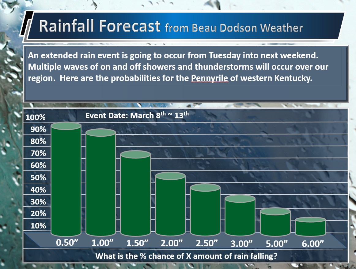
I have adjusted most of the charts to reflect the eastward push of the heavier rain axis. The area of most uncertainty is the Pennyrile area of western Kentucky.
I will post the updated maps in the comment section below.
Higher totals are possible in pockets. Flash flood risk is significant. Avoid flooded roadways.
6 AM Wednesday update: New updates will be posted above this one.
To say the least this is a complex forecast. Partly because there will be large differences in weather from west to east. And, there will be times when southeast Missouri is receiving heavy downpours while parts of the region are dry. Keep that in mind when reading the forecast. I would recommend scrolling down and viewing the 12 hour rainfall graphics. I posted them through Friday. You can at least get some idea of how much rain to expect during any 12 hour period.
New graphics
Updated flash flood watch
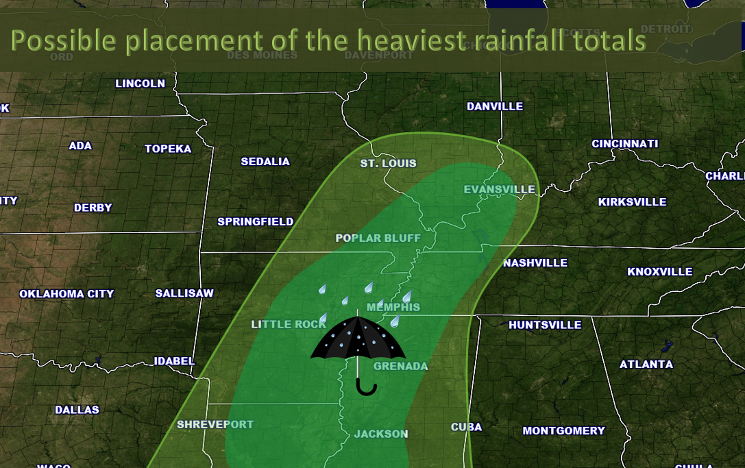
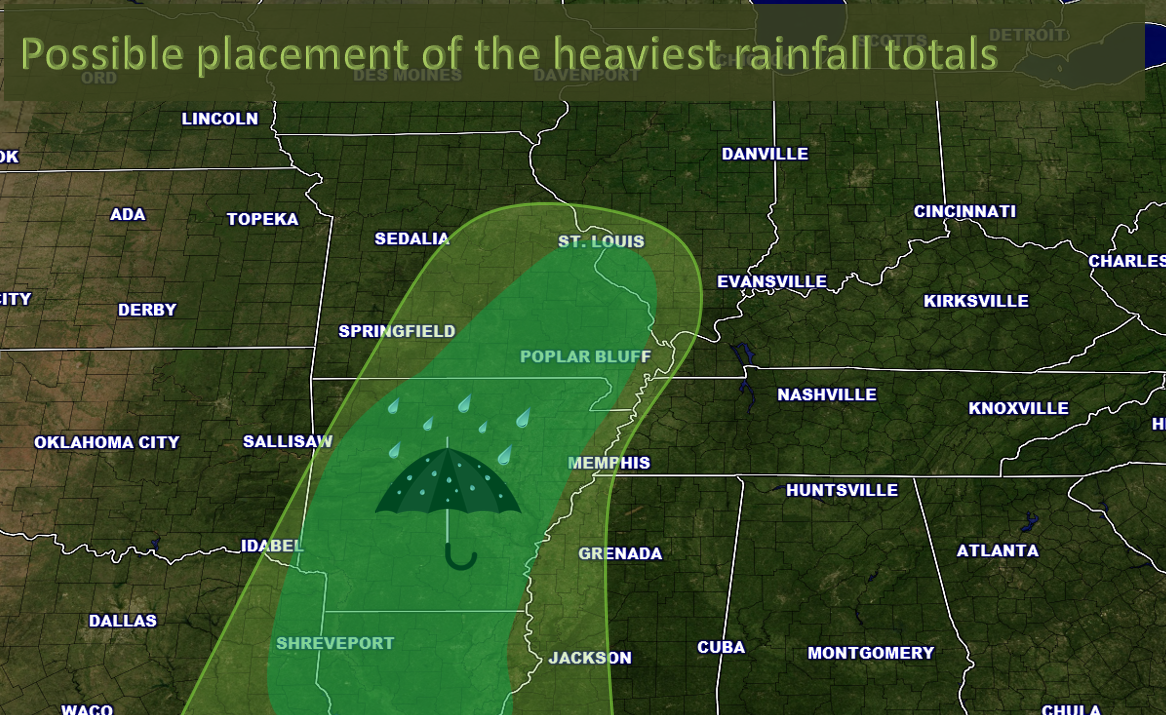
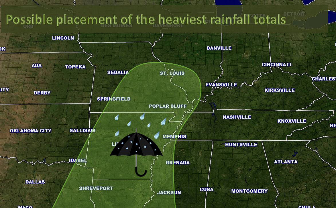
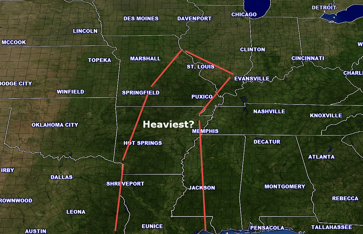
Where is the heaviest rain anticipated to fall? The inner green zone.
Latest anticipated forecast numbers. There is a 70% chance of this map verifying.
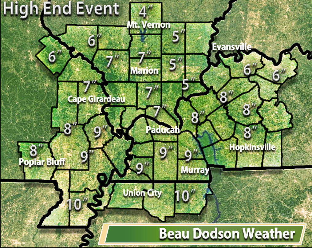
High end event. What is this event over-performed? What is the maximum amount of rainfall that might fall. There is a 15% chance of this happening.
What if this event under-performed? There is a 15% chance of this happening.
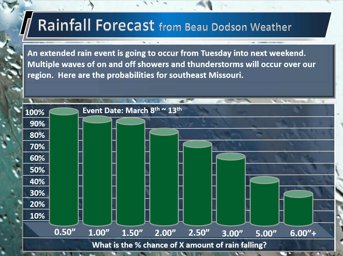
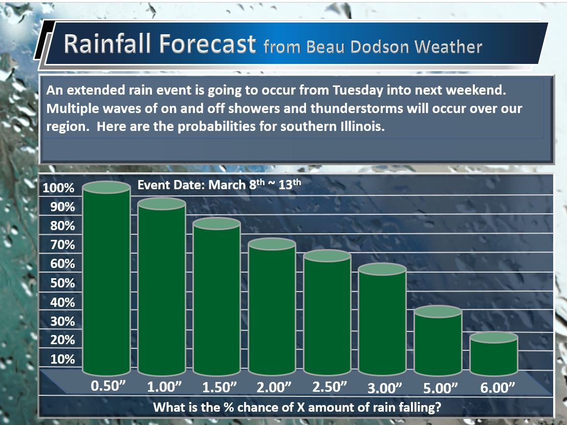
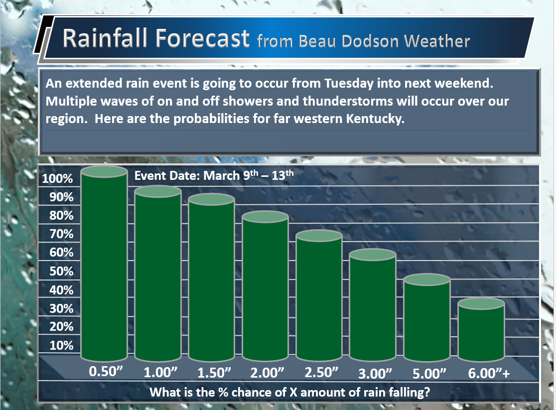
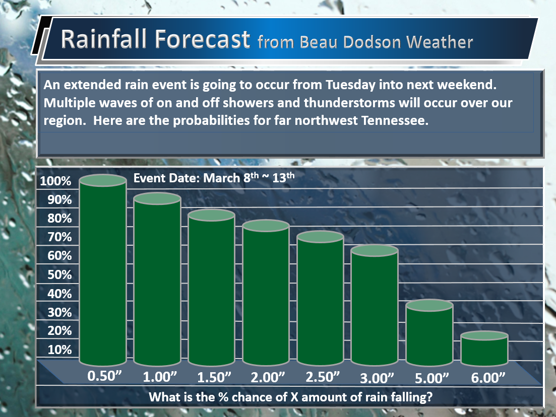
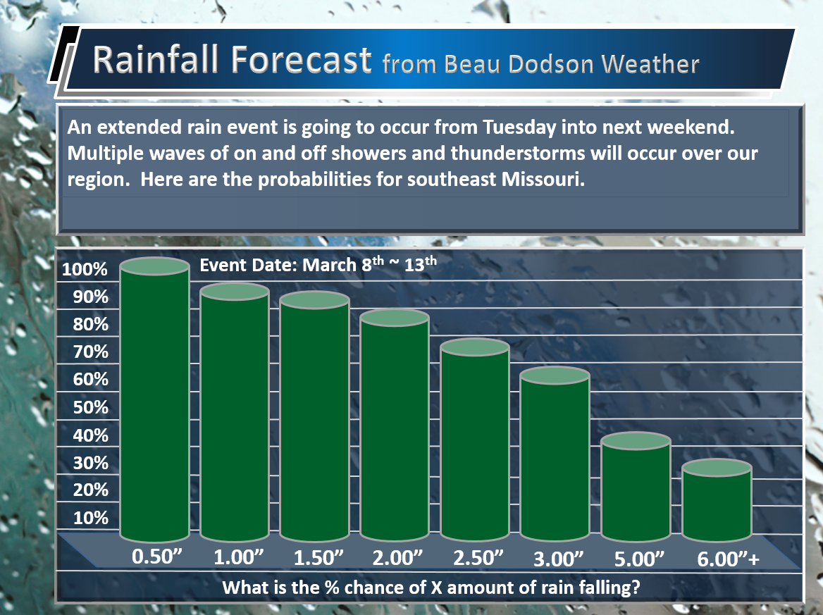
Here are the latest probability charts.
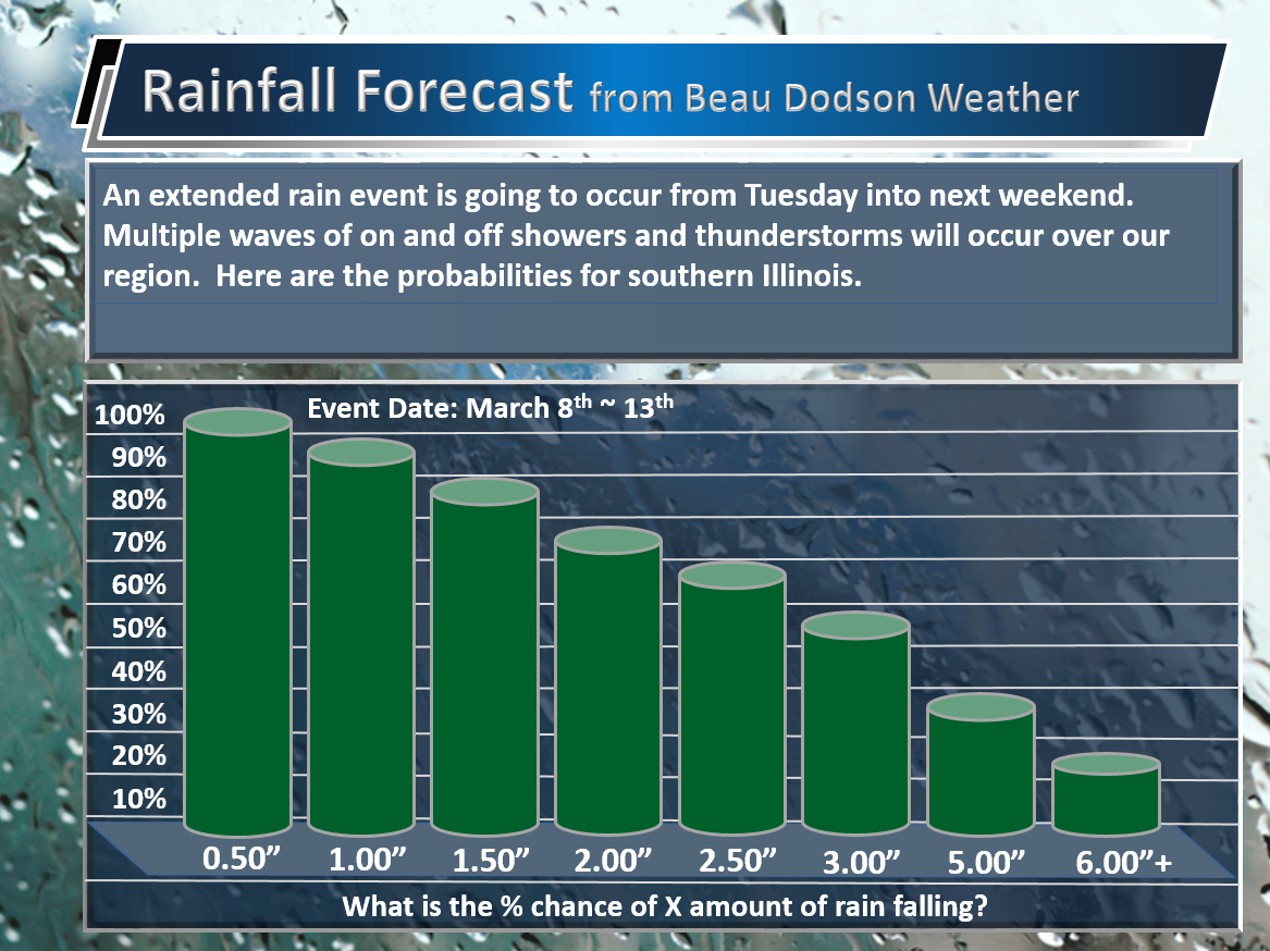
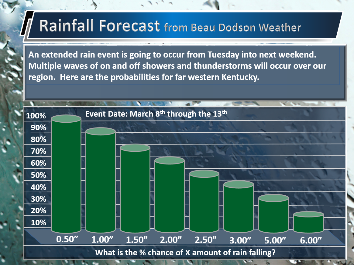
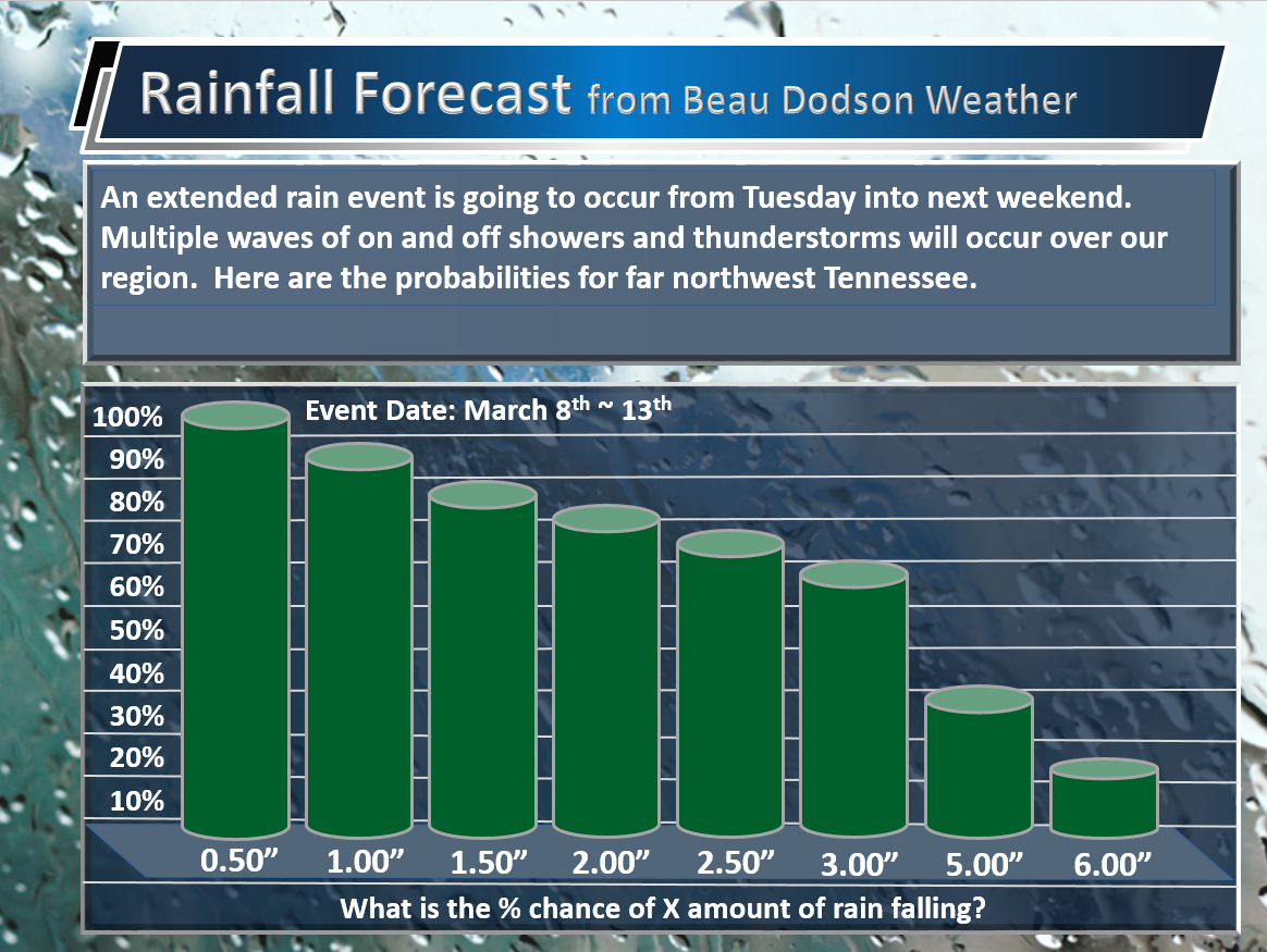
What is the % percent chance of X amount of rain falling. You will notice there are some VERY high numbers. That means to expect some big numbers of a few spots. These are averages for each area. Thus, when you see large numbers that is an indication of a big rain event.
The six inch totals represent six or MORE inches.
Southeast Missouri
Southern Illinois
Western Kentucky
The Pennyrile area of western Kentucky (below)
Northwest Tennessee (below)
6 PM Tuesday update: New updates will be posted above this one.
A flash flood and flood watch has been issued for all of southeast Missouri and parts of southern Illinois. The watch will last through Thursday. The watch means that heavy rainfall is anticipated over the coming days. And, some flooding could occur. Avoid flooded roadways. Dozens of people died in December because they drove into flood waters.
Here are the watches
Here are the latest numbers.
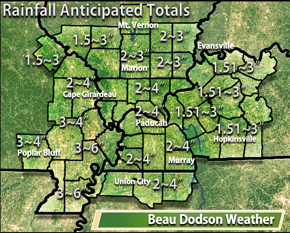
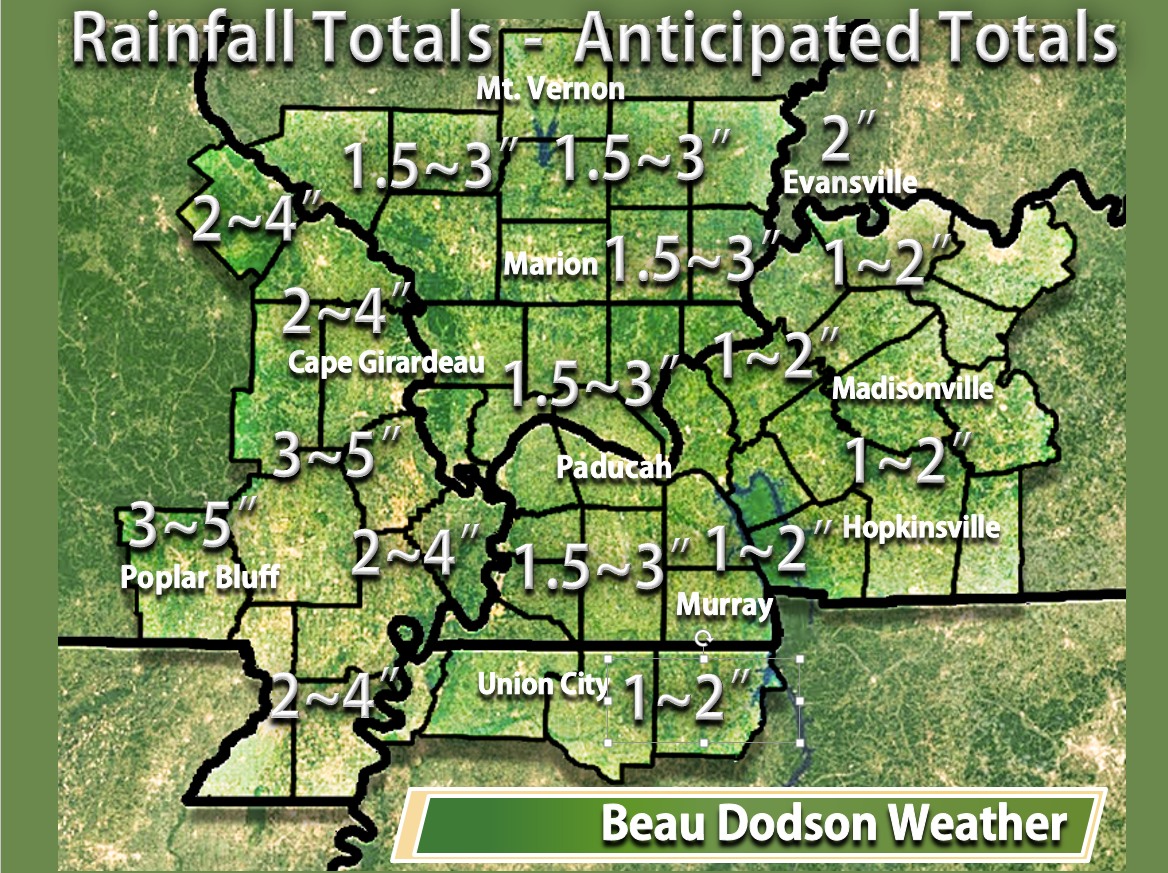
Anticipated totals. This is what I expect to fall from Tuesday into the weekend. Several days of on/off rain. Won’t rain all the time. Periods of rain.
Here are the over/under numbers.
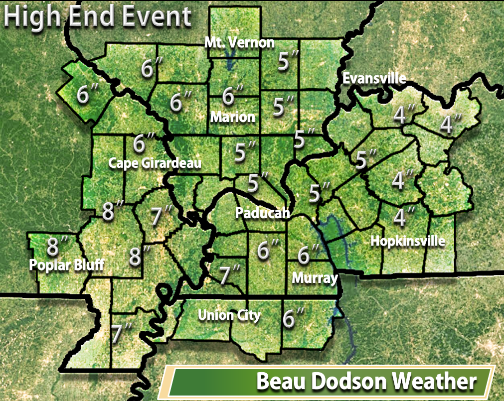
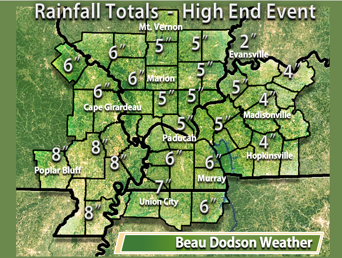
If the event were to exceed expectations. How much rain could fall between Tuesday and Sunday.
Here are the high end numbers.
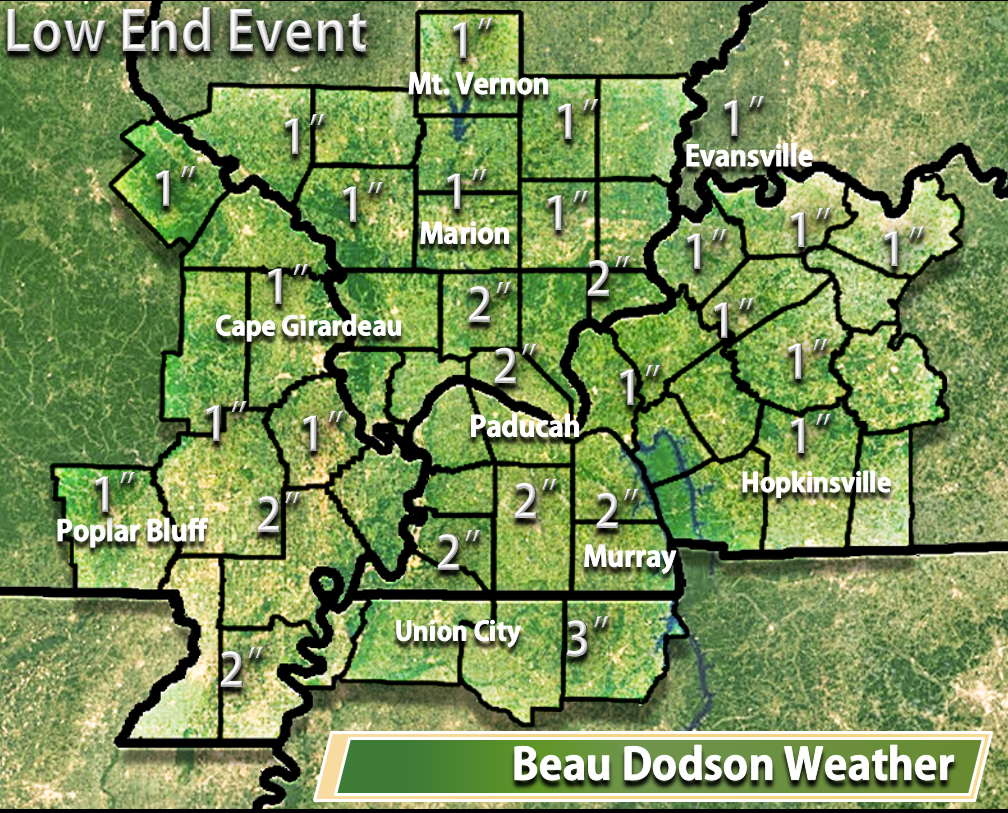
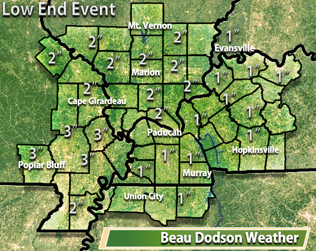
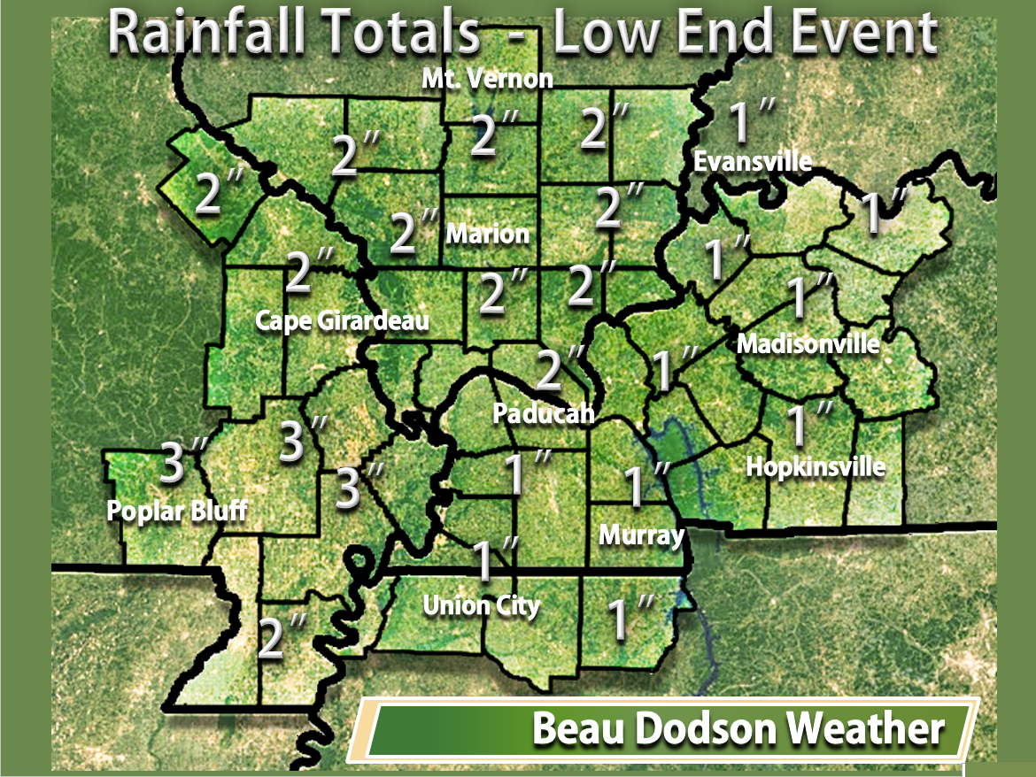
Here are the low end numbers. Low end meaning if the system were to produce less than anticipated. The anticipated numbers represents my forecast. But, weather is always about probabilities. The anticipated numbers represent what to should fall.
Here is the low end event forecast numbers
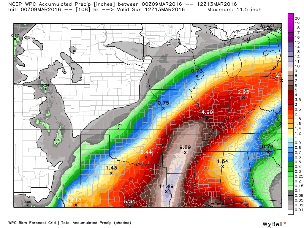
Brand new numbers from NOAA. Here is their latest projections for rainfall totals. Totals have been increased a bit.
Data today did increase the numbers. We need to monitor this. I am very concerned about southern Missouri and Arkansas.
4 PM Monday update: New updates will be posted above this one.
Forecast looks to be on track. No changes in my graphics since Friday. See them further down in this update.
Some showers and storms are possible on Tuesday over southeast Missouri and southern Illinois. Chances spread east Tuesday night into Wednesday. The front may waver back and forth through the end of the week. On and off rain chances.
It won’t rain all of the time. Periods of showers and thunderstorms. Not anticipating severe weather.
A widespread 1.5-3″ rain event is forecast for the region. And, locally much higher totals are possible over southeast Missouri and southern Illinois.
Rivers will rise over the coming 14 days.
9 PM Sunday update: New updates will be posted above this one.
NAM guidance is far west with a lot of the rain on Wednesday. It does not have much support from other data. At least right now. But, it is a short range model and normally would or should be more accurate. Will need to monitor trends in the data. Perhaps a shift west will occur.
11 AM Sunday update: New updates will be posted above this one.
Here is my first forecast for rainfall totals.
Anticipated totals. This is what I expect to fall from Tuesday into the weekend. Several days of on/off rain. Won’t rain all the time. Periods of rain.
Here are the over/under numbers.
If the event were to exceed expectations. How much rain could fall between Tuesday and Sunday.
Here are the high end numbers.
Here are the low end numbers. Low end meaning if the system were to produce less than anticipated. The anticipated numbers represents my forecast. But, weather is always about probabilities. The anticipated numbers represent what to should fall.
Here is the low end event forecast numbers
Let’s take a look at my first forecast attempt at the probabilities.
I usually do this for snowstorms. But, I also put these out for heavy rain events. What is the percent probability for X amount of rain falling.
This first chart is for southeast Missouri
This next graphic is for southern Illinois
This next chart is for western Kentucky
This next chart is for the Pennyrile area of western Kentucky
This last chart is for northwest Tennessee
The overnight data has shown very little in the way of changes. I believe the heaviest totals will stretch from Arkansas into Missouri and Illinois. Here is where the greatest risk for the large totals will be centered. The darker green is the highest risk zone.
5 PM Saturday update: New updates will be posted above this one.
WPC/NOAA has updated their graphic. Here it is.
2 PM Saturday update: New updates will be posted above this one
Confidence is medium to high on the Tuesday through Thursday forecast.
Confidence is medium from Thursday night into Sunday morning.
Confidence on the placement of the heaviest rain band is low to medium.
Showers will move into the region on Tuesday and Tuesday night. But, the heavier rains may hold off until Wednesday into Thursday. A widespread 1.5-3″ rain event is anticipated. And, bands of 3″-6″ will be possible. Locally higher. Below is my initial thoughts on where the largest totals might be located. This event is still several days away. Adjustments are possible. Forecasts are not static. They evolve with time as confidence rises.
Second update on where the heaviest rain might be centered. Totals over 3″ will be possible within the green zone. And, areas outside of the box certainly could also experience significant rainfall, as well. The green area represents where I believe the highest totals could occur.
There remain questions on how much thunderstorm activity will occur later this week. If we end up with numerous thunderstorms then the risk for flash flooding will increase. Monitor updates.
If you have experienced flooding problems in the past from large rain events then you might have concerns. Especially for general flooding vs flash flooding. And, if thunderstorms do occur then areas that have issues with flash flooding could also be impacted.
Large rises on area rivers may occur over the next 14 days. And, additional precipitation is possible next week. Spring has arrived and so have the spring rains. There is an above average risk for river flooding this year.
The National Weather Service has issued a few statements concerning this event.
Hydrological outlook from the Paducah, KY NWS – Click here
Special statement from the St Louis, MO NWS – Click here
The latest data indicates that we may have to deal with showers and thunderstorms on both Saturday and Sunday of next weekend. The atmosphere could be more unstable next Saturday and Sunday. Strong storms can’t be ruled out. Still a bit of time to monitor that part of the forecast.
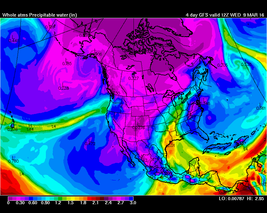
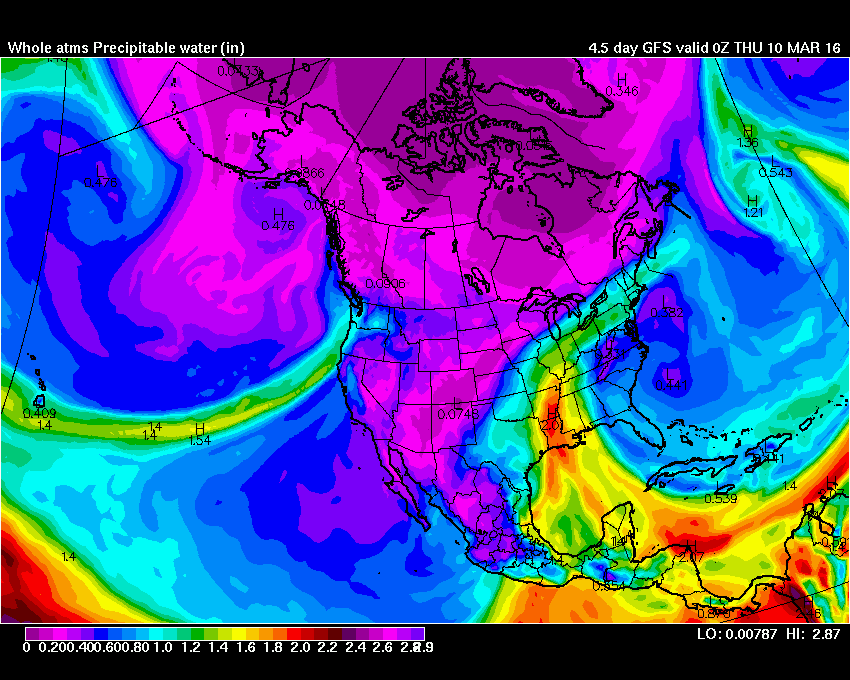
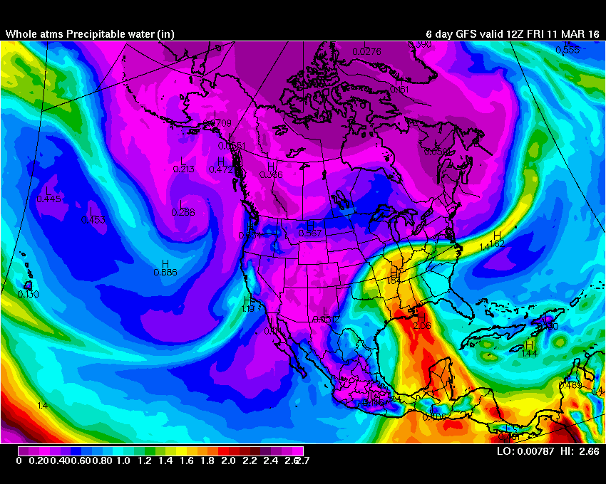
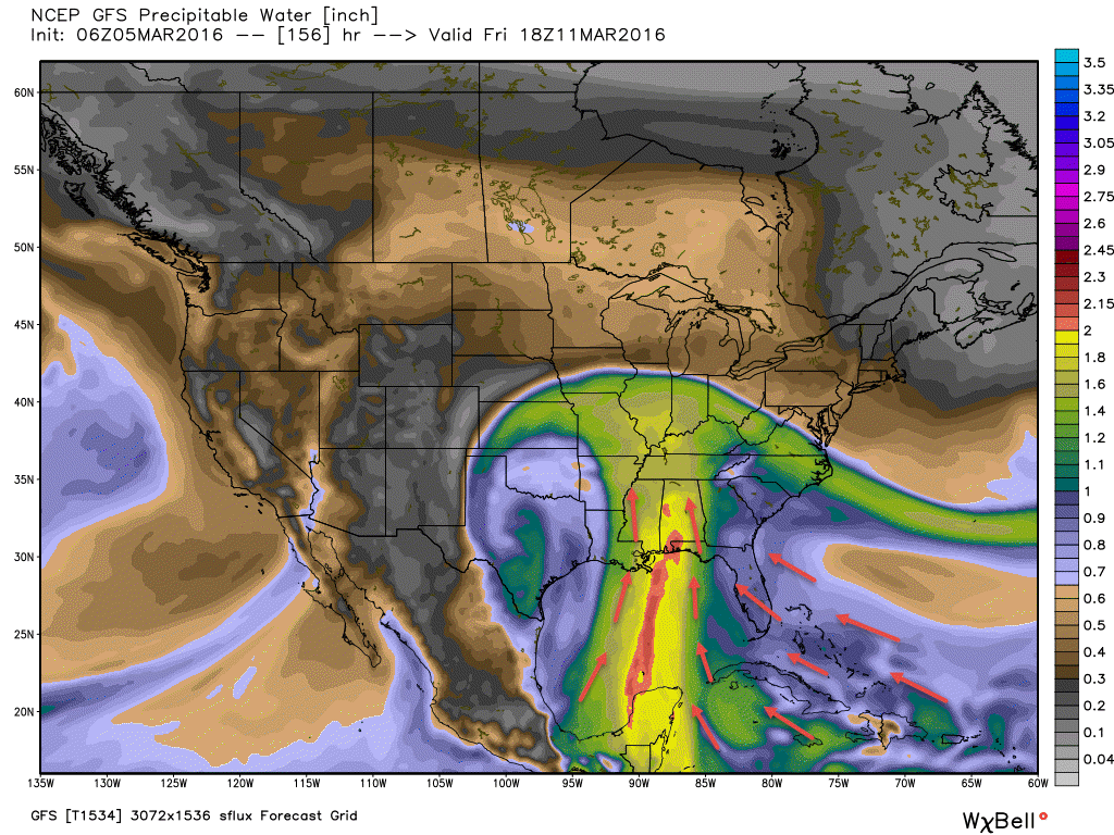
Look at the incredible moisture feed from the tropics. This system will have all the ingredients for widespread rain over much of the central and southern United States.
The bright colors are high PWAT values. PWAT is a measure of moisture in the atmosphere. Look how it comes up from the Caribbean and the Gulf of Mexico. RICH moisture.
Wednesday
Thursday
Friday
7 AM Saturday update: New updates will be posted above this one
Heavy rain event next week:
Confidence is medium to high that a heavy rain event will occur Tuesday into Thursday.
Widespread 1.5-3″ rainfall totals. And, bands of higher rainfall totals likely somewhere in the region.
Severe weather risk appears low.
Flooding is the main concern. Sharp rises on rivers, streams, creeks, overland flooding possible, and perhaps flash flooding.
Least confidence in flash flooding. This will depend on thunderstorm activity. Thunderstorms would produce heavier rain totals in a short amount of time.
Location, location, location. That is the big question for the big totals.
This system is still three days out. That means adjustments in the forecast are possible.
I continue to monitor trends in the guidance. Last night I told you that at this point the heavy rain event appears almost certain for parts of the region.
Much of the guidance has been centering the heaviest rain totals over Missouri and Illinois. The overnight data showed that, as well.
I have some updated rainfall total maps below.
I have noted some northwest trend over the last 24 hours. Meaning, the heaviest rain band pushing a bit further to the west/northwest. Two data sets on Friday made an attempt to shift slightly north and west. Then the guidance brought it back southeast in updated runs. A bit of a back and forth.
Data has attempted to show this from time to time. I believe this is the trend. The trend is north and west. Today will be telling. If all of the guidance continues a bit of a northwest trend that they may be catching on to something.
The good news is that perhaps that would spare parts of our region the 4″-8″ rain band. The bad news is that this would place the rain further north and west. That would mean more water flowing down the Mississippi River.
This isn’t a case of will it or won’t it rain. This is a case of how much will it rain.
I am forecasting widespread 1.5-3″ of rain for the entire region. And, some bands of much heavier totals likely. Odds appear to favor the heaviest bands being somewhere in Missouri and Illinois. Whether over or north and west of my forecast counties remains a question. I will post a graphic below of the area I am most concerned about (for the time being, at least).
Data has been very consistent in painting widespread rain from Tuesday into Thursday. Some thunderstorms are also possible. Severe weather threat appears low. Main concern will be flooding.
Rivers are already high. We do not need this rain.
The guidance indicates an active few weeks ahead of us.
I will post some updated maps below.
This is my first forecast thoughts on where the heaviest rain may fall. The red boxed area.
Below is the GFS guidance. The heaviest band has been shifting around by a few counties from run to run. We will see how new data plays out today.
And, here is the latest WPC/NOAA forecast for rainfall totals. This has shifted a bit west and northwest, as well
Moisture will be streaming in from the Atlantic, Caribbean, and the Gulf of Mexico. Here is the PWAT value map. PWAT’s are a measure of moisture in the atmosphere.
I have launched the new weather texting service! I could use your help. Be sure and sign up and fully support all of the weather data you see each day.
This is a monthly subscription service. Supporting this helps support everything else. The cost is $3 a month for one phone, $5 a month for three phones, and $10 a month for seven phones.
For more information visit BeauDodsonWeather.com
Or directly sign up at Weathertalk.com
