We have some great sponsors for the Weather Talk Blog. Please let our sponsors know that you appreciate their support for the Weather Talk Blog.
Milner and Orr Funeral Home and Cremation Services located in Paducah, Kentucky and three other western Kentucky towns – at Milner and Orr they believe in families helping families. You can find Milner and Orr on Facebook, as well.
![]()
.

For all of your families eye care needs. Visit their web-site here. Or, you can also visit their Facebook page.
.

Best at Enabling Body Shop Profitability since 1996. Located In Paducah Kentucky and Evansville Indiana; serving all customers in between. They provide Customer Service, along with all the tools necessary for body shops to remain educated and competitive. Click the logo above for their main web-site. You can find McClintock Preferred Finishes on Facebook, as well

Expressway Carwash and Express Lube are a locally owned and operated full service Carwash and Lube established in 1987. We have been proudly serving the community for 29 years now at our Park Avenue location and 20 years at our Southside location. We have been lucky enough to partner with Sidecar Deli in 2015, which allows us to provide our customers with not only quality service, but quality food as well. . If you haven’t already, be sure to make Expressway your one stop shop, with our carwash, lube and deli. For hours of operation and pricing visit www.expresswashlube.com or Expressway Carwash on Facebook.
I have launched the new weather texting service! I could use your help. Be sure and sign up and fully support all of the weather data you see each day.
This is a monthly subscription service. Supporting this helps support everything else. The cost is $3 a month for one phone, $5 a month for three phones, and $10 a month for seven phones.
For more information visit BeauDodsonWeather.com
Or directly sign up at Weathertalk.com


This forecast update covers far southern Illinois, far southeast Missouri, and far western Kentucky. See the coverage map on the right side of the blog.
Remember that weather evolves. Check back frequently for updates, especially during active weather.

Weather Radars
WEATHER RADAR PAGE – Click here
Scroll down for a longer morning update:
I am starting a blog update just for the flood event (I might start doing this for events). Link.
Friday Night – Partly cloudy and cool.
Temperatures: Lows in the 34-38 degree range.
Winds: Winds south at 5-10 mph.
What is the chance for precipitation? 0%
Coverage of precipitation? None
My confidence in this part of the forecast verifying is High
Should I be concerned about snow or ice? No
Should I cancel my outdoor plans? No
Is severe weather expected? No
What impact is expected? None
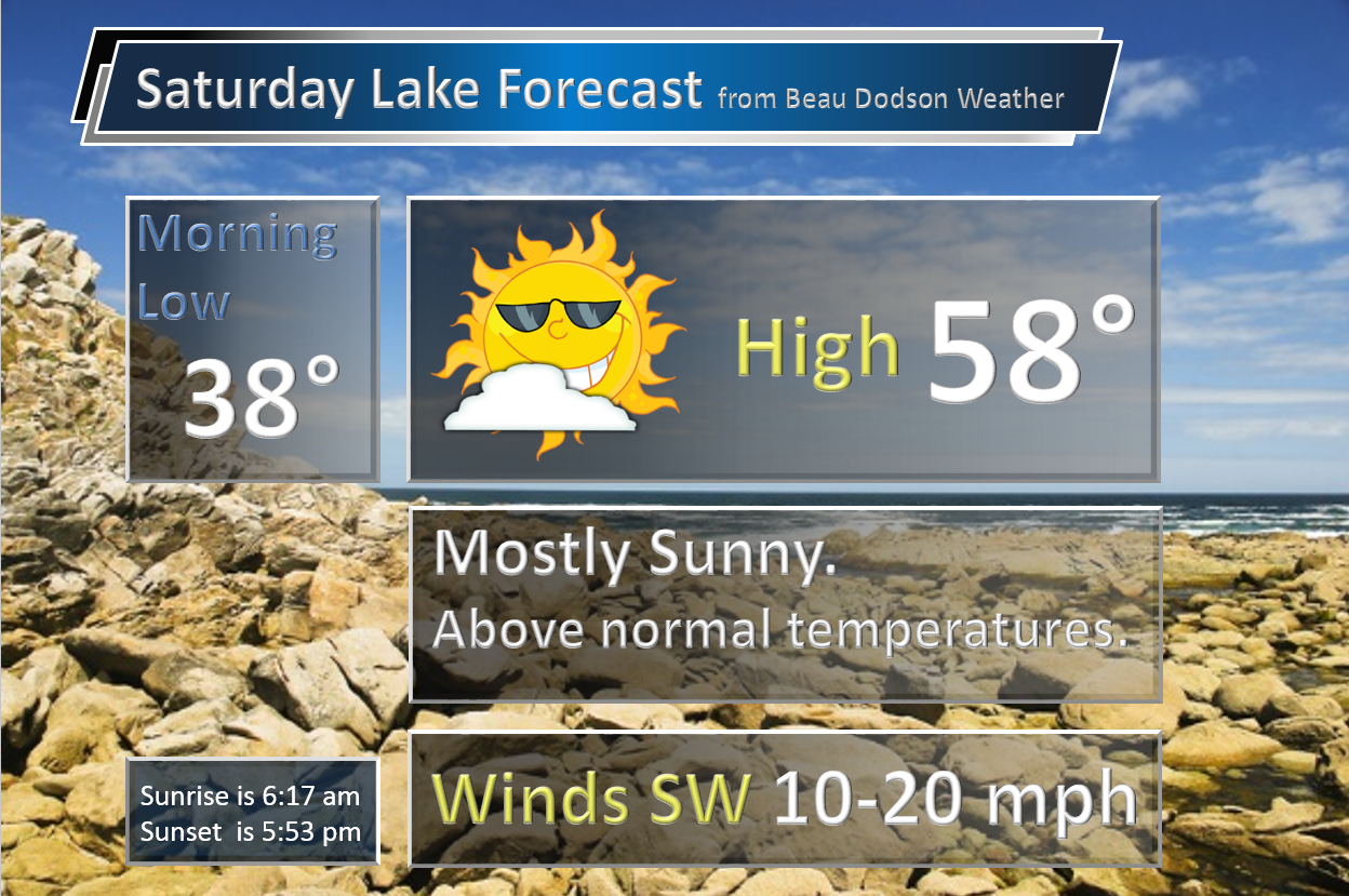
Saturday – Partly cloudy. More clouds over NW Kentucky into the Pennyrile area. A few showers can’t be ruled out.
Temperatures: High temperatures from 58-64 degrees.
Winds: Southwest/west winds at 5-10 mph. Variable winds in the afternoon (direction).
What is the chance for precipitation? 20% over the eastern counties
Coverage of precipitation? Isolated or spotty. Eastern counties. That includes NW Kentucky into the Pennyrile area.
My confidence in this part of the forecast verifying is High
Should I be concerned about snow or ice? No
Should I cancel my outdoor plans? No
Is severe weather expected? None.
What impact is expected? None
Saturday Night – A few evening clouds. And showers over the eastern counties of the region should be ending. Then, becoming mostly clear and cold.
Temperatures: Lows in the 28-34 degree range.
Winds: Winds north/northwest at 5-10 mph.
What is the chance for precipitation? 10%
Coverage of precipitation? None
My confidence in this part of the forecast verifying is High
Should I be concerned about snow or ice? No
Should I cancel my outdoor plans? No
Is severe weather expected? No
What impact is expected? None
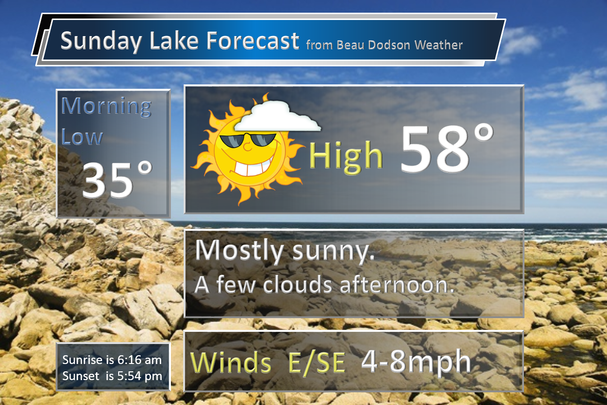
Sunday – A few clouds, but quite a bit of sun. Mild.
Temperatures: High temperatures from 58-64 degrees.
Winds: East and southeast winds at 6-12 mph.
What is the chance for precipitation? 0%
Coverage of precipitation? None
My confidence in this part of the forecast verifying is High
Should I be concerned about snow or ice? No
Should I cancel my outdoor plans? No
Is severe weather expected? No
What impact is expected? None
Sunday Night – Cloudy. Not as cold.
Temperatures: Lows in the 44-48 degree range.
Winds: Winds south at 6-12 mph.
What is the chance for precipitation? 10%
Coverage of precipitation? None to isolated
My confidence in this part of the forecast verifying is High
Should I be concerned about snow or ice? No
Should I cancel my outdoor plans? No
Is severe weather expected? No
What impact is expected? None
Monday – Mix of sun and clouds. Mild. Above normal temperatures.
Temperatures: High temperatures from 64-68 degrees.
Winds: South winds at 8-16 mph. Gusts to 20 mph.
What is the chance for precipitation? 10%
Coverage of precipitation? None to isolated
My confidence in this part of the forecast verifying is Medium
Should I be concerned about snow or ice? No
Should I cancel my outdoor plans? No
Is severe weather expected? No
What impact is expected? Maybe a few showers. Wet roadways.
Monday Night – Cloudy. A few showers possible.
Temperatures: Low temperatures well above normal in the 54-58 degree range.
Winds: South at 8-16 mph. Gusty.
What is the chance for precipitation? 40%
Coverage of precipitation? Scattered
My confidence in this part of the forecast verifying is Medium
Should I be concerned about snow or ice? No
Should I cancel my outdoor plans? Maybe some showers
Is severe weather expected? No
What impact is expected? Maybe some wet roadways.
Tuesday – Showers and some thunderstorms. Mild.
Temperatures: High temperatures 65-70 degrees.
Winds: South at 10-20 mph.
What is the chance for precipitation? 40%-60%
Coverage of precipitation? Becoming widespread
My confidence in this part of the forecast verifying is Medium
Should I be concerned about snow or ice? No
Should I cancel my outdoor plans? Some rain possible
Is severe weather expected? Not at this time
What impact is expected? Wet roadways. Lightning possible.
Tuesday Night – Showers and thunderstorms likely.
Temperatures: Lows in the 55-60 degree range
Winds: South at 10-20 mph.
What is the chance for precipitation? 70%
Coverage of precipitation? Widespread
My confidence in this part of the forecast verifying is High
Should I be concerned about snow or ice? No
Should I cancel my outdoor plans? Rain likely to be an issue
Is severe weather expected? Not at this time
What impact is expected? Wet roadways. Lightning possible.
Wednesday – Showers and thunderstorms. Heavy rain possible.
Temperatures: High temperatures 64-68 degrees.
Winds: South at 10-20 mph.
What is the chance for precipitation? 80%
Coverage of precipitation? Widespread
My confidence in this part of the forecast verifying is Medium
Should I be concerned about snow or ice? No
Should I cancel my outdoor plans? Rain could be an issue. Have a plan B
Is severe weather expected? Not at this time
What impact is expected? Heavy rain. Lightning possible. Some flooding can’t be ruled out. Monitor updates.
Our School Bus Stop Forecast is sponsored by Heath Health and Wellness.

Heath Health Foods is a locally owned and operated retail health and wellness store. Since opening in February 2006; the store has continued to grow as a ministry with an expanding inventory which also offers wellness appointments and services along with educational opportunities. Visit their web-site here. And. visit Heath Health Foods on Facebook!


Don’t forget to check out the Southern Illinois Weather Observatory web-site for weather maps, tower cams, scanner feeds, radars, and much more! Click here

An explanation of what is happening in the atmosphere over the coming days…
Saturday morning update:
Welcome to the weekend! We have some clouds this morning, especially over the eastern half of the region. Some light showers and sprinkles earlier this morning are pushing off to the east/southeast.
Clouds will take the longest to clear over our eastern counties. Pennyrile area of western Kentucky.
Dry weather is expected the rest of today into Sunday.
Gusty winds arrive on Monday. 30-40 mph winds over southeast Missouri and southern Illinois. 20-35 mph winds elsewhere.
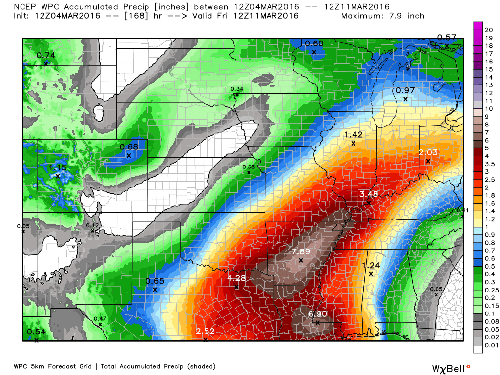
Heavy rain event next week?
Confidence is medium to high that a heavy rain event will occur Tuesday into Thursday.
Widespread 1.5-3″ rainfall totals. And, bands of higher rainfall totals likely somewhere in the region.
Severe weather risk appears low.
Flooding is the main concern. Sharp rises on rivers, streams, creeks, overland flooding possible, and perhaps flash flooding.
Least confidence in flash flooding. This will depend on thunderstorm activity. Thunderstorms would produce heavier rain totals in a short amount of time.
Location, location, location. That is the big question for the big totals.
This system is still three days out. That means adjustments in the forecast are possible.
I continue to monitor trends in the guidance. Last night I told you that at this point the heavy rain event appears almost certain for parts of the region.
Much of the guidance has been centering the heaviest rain totals over Missouri and Illinois. The overnight data showed that, as well.
I have some updated rainfall total maps below.
I have noted some northwest trend over the last 24 hours. Meaning, the heaviest rain band pushing a bit further to the west/northwest. Two data sets on Friday made an attempt to shift slightly north and west. Then the guidance brought it back southeast in updated runs. A bit of a back and forth.
Data has attempted to show this from time to time. I believe this is the trend. The trend is north and west. Today will be telling. If all of the guidance continues a bit of a northwest trend that they may be catching on to something.
The good news is that perhaps that would spare parts of our region the 4″-8″ rain band. The bad news is that this would place the rain further north and west. That would mean more water flowing down the Mississippi River.
This isn’t a case of will it or won’t it rain. This is a case of how much will it rain.
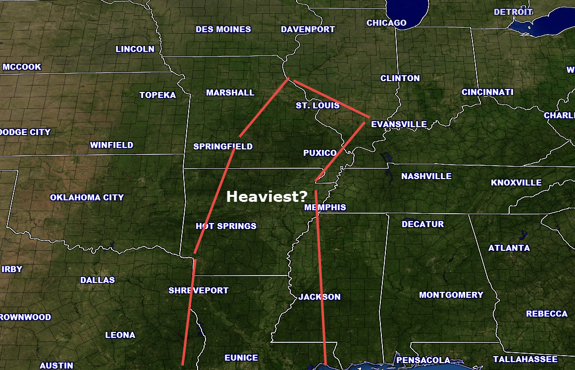
I am forecasting widespread 1.5-3″ of rain for the entire region. And, some bands of much heavier totals likely. Odds appear to favor the heaviest bands being somewhere in Missouri and Illinois. Whether over or north and west of my forecast counties remains a question. I will post a graphic below of the area I am most concerned about (for the time being, at least).
Data has been very consistent in painting widespread rain from Tuesday into Thursday. Some thunderstorms are also possible. Severe weather threat appears low. Main concern will be flooding.
Rivers are already high. We do not need this rain.
The guidance indicates an active few weeks ahead of us.
I will post some updated maps below.
This is my first forecast thoughts on where the heaviest rain may fall. The red boxed area.
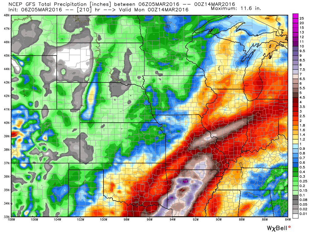
Below is the GFS guidance. The heaviest band has been shifting around by a few counties from run to run. We will see how new data plays out today.
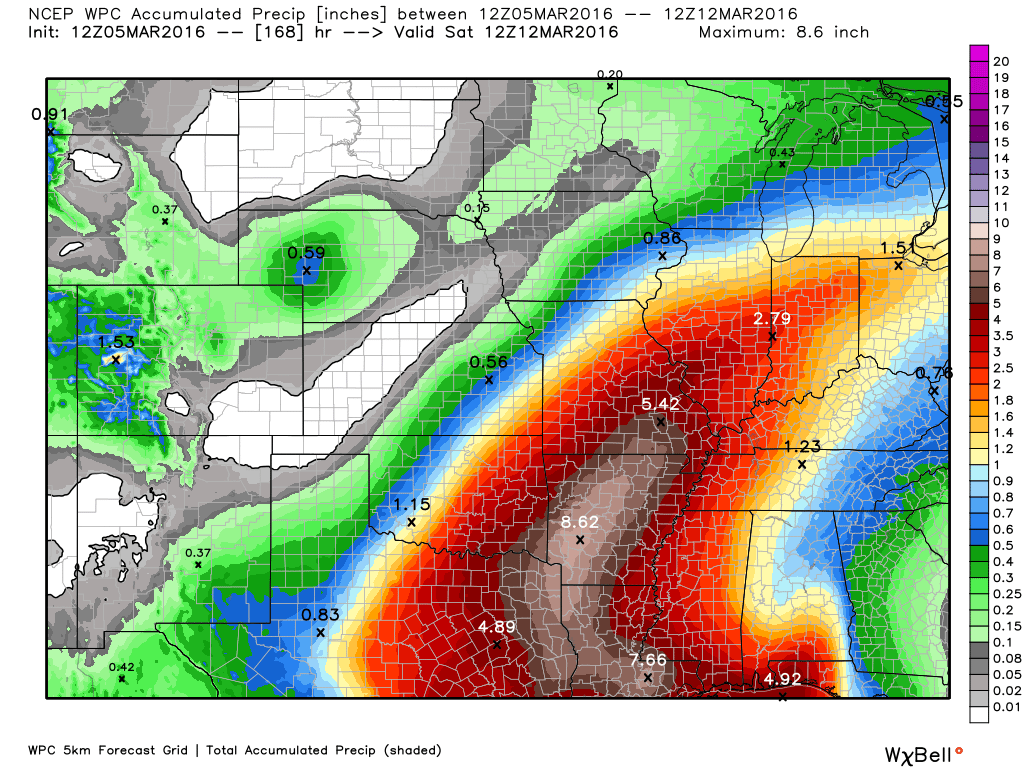
And, here is the latest WPC/NOAA forecast for rainfall totals. This has shifted a bit west and northwest, as well
8 PM Update
If you have concerns about flooding then closely monitor updates forecasts. This event is still four days out. And, changes in the forecast are possible.
Highlights
1. Decent weekend ahead of us
2. All eyes on next week. Heavy rain event likely.
Today is a travel day for me. Couple of items to discuss.
A weak system will pass to our northeast on Saturday. This could trigger a few showers from southeast Illinois into the Pennyrile area of western Kentucky Cloudier east vs west.
The big weather story continues to be the potential for a heavy rain event next week. It is a bit early to pin down just how much rain will fall in each county.
At this time, I am expecting all of my forecast counties to pick up 1.5 to 3 inches of rain. Guidance shows a lot more rain falling than 1.5 to 3 inches. But, this is still days away. And, guidance can shift.
It is likely that someone in the Missouri, Ohio, and Tennessee Valleys will pick up more than six inches of rain from this event. Flooding is a concern.
I am not sure where the heaviest band will occur. There has been some shift northward over the past 24 hours on the GFS model. Shifting the heaviest band into Missouri and parts of Illinois.
Other guidance places the heaviest band right on top of us.
Continue to monitor updates concerning this potential flood event. The forecast will be fine tuned over the coming days. Flash flood or flood watches will likely be issued for parts of the region next week.
I will post more information over the coming days.
The severe weather threat is not zero, but does not look great. Heavy rain may be the main concern from next weeks event.
Weekend Forecast:
Expect dry weather on Friday into Sunday.
Camping forecast. Gusty winds on Saturday. Maybe a few clouds from time to time.

Can we expect severe thunderstorms over the next 24 to 48 hours? Remember that a severe thunderstorm is defined as a thunderstorm that produces 58 mph winds or higher, quarter size hail or larger, and/or a tornado.
.
Friday – The thunderstorm thread level will be zero
Saturday – The thunderstorm thread level will be zero
Sunday – The thunderstorm thread level will be zero

No major changes in this update.
.

Monitoring next week for the potential for heavy rain.

No. Several days of calm weather.

How much precipitation should we expect over the next few days?
No significant rain through Sunday. Heavy rain likely next week.
This is a preliminary look at how much rain could fall next Tuesday and Wednesday/Thursday. Showers may arrive as early as Sunday night and Monday. Heavier rain Tuesday and Wednesday.
What to take from this graphic?
Confidence level is medium that a heavy rain event will occur next week.
NOAA has released this graphic. Keep in mind, there will likely be shifts in where the heaviest rain will fall. This is a very early forecast. Big totals.

Here is the official 6-10 day and 8-14 day temperature and precipitation outlook. Check the date stamp at the top of each image (so you understand the time frame).
The forecast maps below are issued by the Weather Prediction Center (NOAA).


The latest 8-14 day temperature and precipitation outlook. Note the dates are at the top of the image. These maps DO NOT tell you how high or low temperatures or precipitation will be. They simply give you the probability as to whether temperatures or precipitation will be above or below normal.


Here are the current river stage forecasts. You can click your state and then the dot for your location. It will bring up the full forecast and hydrograph.
Click Here For River Stage Forecasts…

Who do you trust for your weather information and who holds them accountable?
I have studied weather in our region since the late 1970’s. I have 37 years of experience in observing our regions weather patterns. My degree is in Broadcast Meteorology from Mississippi State University and an Associate of Science (AS). I am currently working on my Bachelor’s Degree in Geoscience.
My resume includes:
Member of the American Meteorological Society.
NOAA Weather-Ready Nation Ambassador.
Meteorologist for McCracken County Emergency Management. I served from 2005 through 2015.
I own and operate the Southern Illinois Weather Observatory.
Recipient of the Mark Trail Award, WPSD Six Who Make A Difference Award, Kentucky Colonel, and the Caesar J. Fiamma” Award from the American Red Cross.
In 2009 I was presented with the Kentucky Office of Highway Safety Award.
Recognized by the Kentucky House of Representatives for my service to the State of Kentucky leading up to several winter storms and severe weather outbreaks.
I am also President of the Shadow Angel Foundation which serves portions of western Kentucky and southern Illinois.
There is a lot of noise on the internet. A lot of weather maps are posted without explanation. Over time you should learn who to trust for your weather information.
My forecast philosophy is simple and straight forward.
- Communicate in simple terms
- To be as accurate as possible within a reasonable time frame before an event
- Interact with you on Twitter, Facebook, and the blog
- Minimize the “hype” that you might see on television or through other weather sources
- Push you towards utilizing wall-to-wall LOCAL TV coverage during severe weather events
I am a recipient of the Mark Trail Award, WPSD Six Who Make A Difference Award, Kentucky Colonel, and the Caesar J. Fiamma” Award from the American Red Cross. In 2009 I was presented with the Kentucky Office of Highway Safety Award. I was recognized by the Kentucky House of Representatives for my service to the State of Kentucky leading up to several winter storms and severe weather outbreaks.
If you click on the image below you can read the Kentucky House of Representatives Resolution.

Many of my graphics are from www.weatherbell.com – a great resource for weather data, model data, and more


You can sign up for my AWARE email by clicking here I typically send out AWARE emails before severe weather, winter storms, or other active weather situations. I do not email watches or warnings. The emails are a basic “heads up” concerning incoming weather conditions.