
Click one of the links below to take you directly to that section
![]()
![]()
![]()
![]()
![]()
![]()
![]()
.

.
Seven Day Hazardous Weather Outlook
1. Is lightning in the forecast? YES. Lightning is possible Thursday night, but more likely Friday and Friday night. Scattered lightning is possible Saturday, as well.
2. Are severe thunderstorms in the forecast? MONITOR. I am watching southern Missouri into northwest Tennessee Friday and Friday night. We will have to see if the risk spreads farther east northeast. For now, a few storms could produce hail and wind over southern Missouri. The rest of the area has a lightning threat.
3. Is flash flooding in the forecast? ISOLATED ISSUES. Rain is likely again Thursday night into Saturday. Some low-land flooding will be possible. Standing water in ditches and fields. Avoid flooded roadways. Rain totals today will range from 0 to over two inches.
4. Will non-thunderstorm winds top 40 mph? NO.
5. Will the heat index exceed 100 degrees? NO.
6. Will the wind chill dip below 10 degrees? NO.
7. Is measurable snow and/or sleet in the forecast? NO.
8. Is freezing rain/ice in the forecast? NO.
Freezing rain is rain that falls and instantly freezes on objects such as trees and power lines Freezing fog possible, as well.
.
BEAU’S STORM TRACKING RADARS
Interactive-city-view radars. Clickable watches and warnings.
https://wtalk.co/B3XHASFZ
If the radar is not updating then try another one. If a radar does not appear to be refreshing then hit Ctrl F5. You may also try restarting your browser.
Backup radar site in case the above one is not working.
https://weathertalk.com/morani
Regional Radar
https://imagery.weathertalk.com/prx/RadarLoop.mp4
** NEW ** Zoom radar with chaser tracking abilities!
ZoomRadar
.

Fire weather risk level.
Thursday: 4. Low risk.
Thursday night: 4. Low risk.
Friday into Saturday: 3. Very low risk.
Fire Weather Discussion
Showers and thunderstorms will spread across southeast Missouri today, then east of the Mississippi River tonight. Showers and some thunderstorms will continue into Friday night, ending from west to east Saturday. Rainfall totals are expected to be in the 0.5 to 1.5 inch range mostly.
A Haines Index of 6 means a high potential for an existing fire to become large or exhibit erratic fire behavior, 5 means medium potential, 4 means low potential, and anything less than 4 means very low potential.
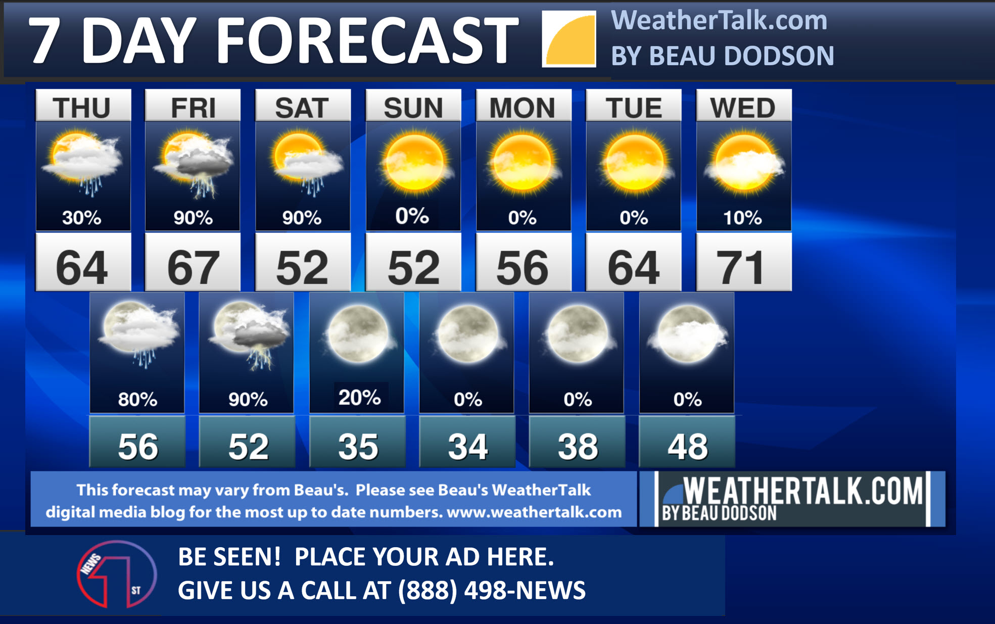
Seven-day forecast for southeast Missouri, southern Illinois, western Kentucky, and western Tennessee.
This is a BLEND for the region. Scroll down to see the region by region forecast.
.

THE FORECAST IS GOING TO VARY FROM LOCATION TO LOCATION. Scroll down to see your local forecast details.
.
Expected rainfall totals. As always, totals will vary. This is the best estimate for the area.

48-hour forecast Graphics


.
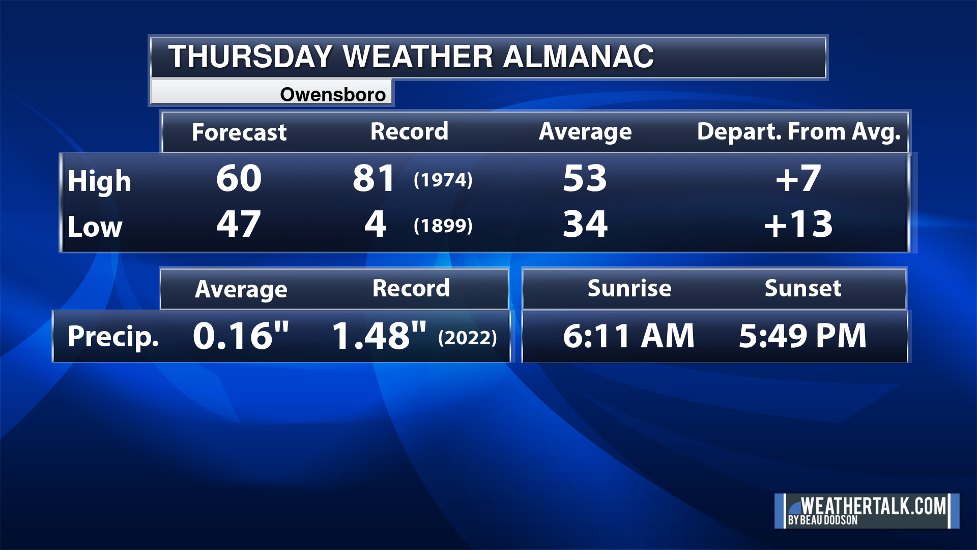
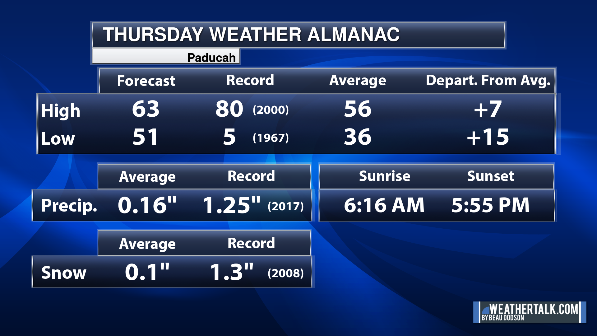
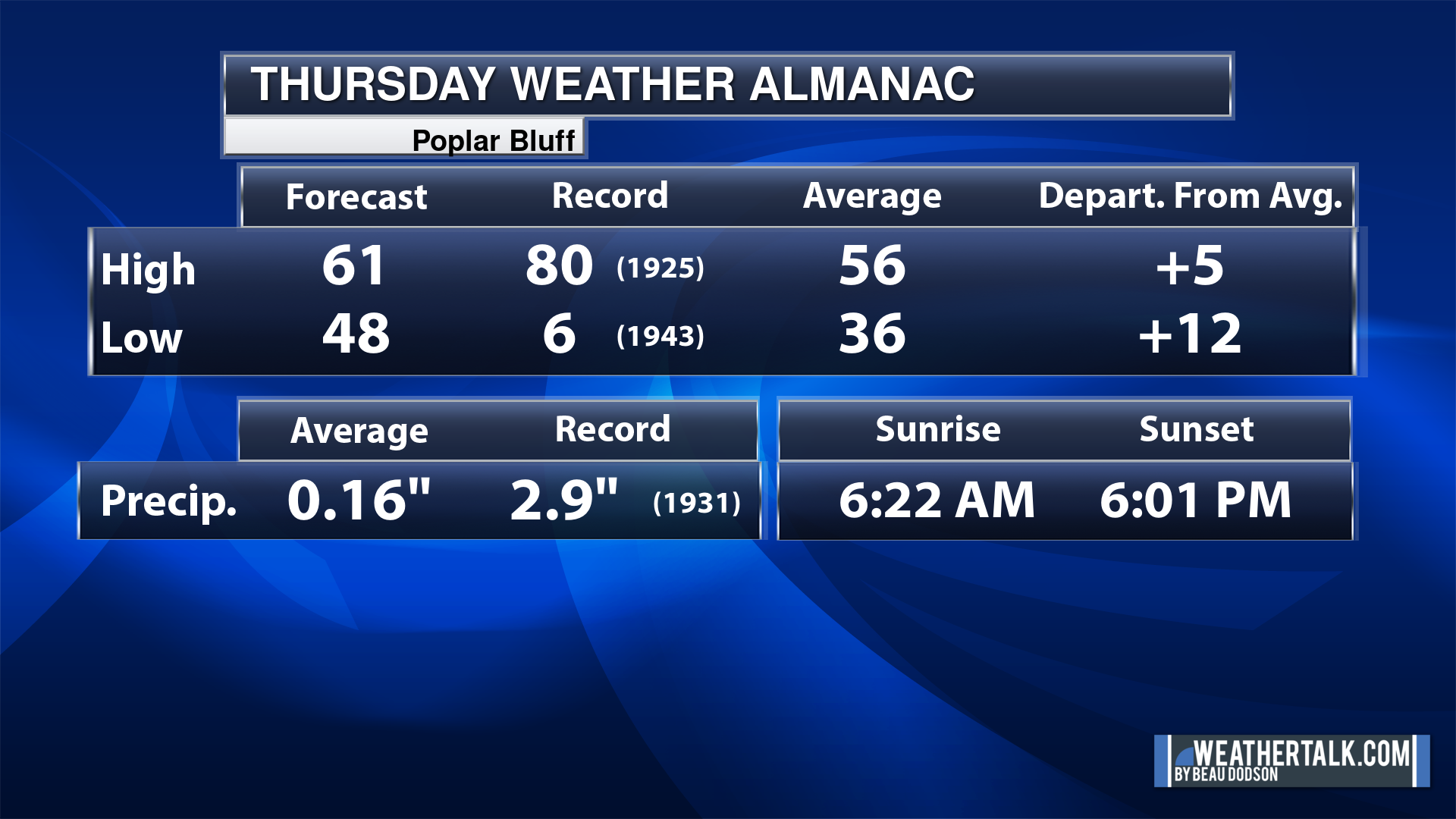
Today’s Local Almanacs (for a few select cities). Your location will be comparable.
Note, the low is this morning’s low and not tomorrows.
The forecast temperature shows you today’s expected high and this morning’s low.
The graphic shows you the record high and record low for today. It shows you what year that occurred, as well.
It then shows you what today’s average temperature is.
It shows you the departures (how may degrees above or below average temperatures will be ).
It shows you the average precipitation for today. Average comes from thirty years of rain totals.
It also shows you the record rainfall for the date and what year that occurred.
The sunrise and sunset are also shown.


![]()
.
.
Thursday Forecast: Thickening clouds. A chance of showers and thunderstorms.
What is the chance of precipitation?
Far northern southeast Missouri ~ 70%
Southeast Missouri ~ 80%
The Missouri Bootheel ~ 80%
I-64 Corridor of southern Illinois ~ 40%
Southern Illinois ~ 40%
Extreme southern Illinois (southern seven counties) ~ 40%
Far western Kentucky (Purchase area) ~ 40%
The Pennyrile area of western KY ~ 30%
Northwest Kentucky (near Indiana border) ~ 30%
Northwest Tennessee ~ 40%
Rain chances
Coverage of precipitation: Becoming numerous over southeast Missouri. Scattered elsewhere. Showers and storms will advance eastward with time.
Timing of the precipitation: After 9 AM over SE MO and after 12 PM elsewhere. Higher coverage west vs east.
Far northern southeast Missouri ~ 58° to 62°
Southeast Missouri ~ 58° to 64°
The Missouri Bootheel ~ 58° to 62°
I-64 Corridor of southern Illinois ~ 58° to 62°
Southern Illinois ~ 60° to 62°
Extreme southern Illinois (southern seven counties) ~ 60° to 62°
Far western Kentucky ~ 63° to 66°
The Pennyrile area of western KY ~ 64° to 68°
Northwest Kentucky (near Indiana border) ~ 62° to 65°
Northwest Tennessee ~ 64° to 68°
Winds will be from this direction: Southeast at 7 to 14 mph. Higher gusts possible.
Wind chill or heat index (feels like) temperature forecast: 52° to 65°
What impacts are anticipated from the weather?
Should I cancel my outdoor plans? No
UV Index: 2. Low.
Sunrise: 6:17 PM
Sunset: 5:58 PM .
.
Thursday Night Forecast: Mostly cloudy with a chance of showers and thunderstorms.
What is the chance of precipitation?
Far northern southeast Missouri ~ 80%
Southeast Missouri ~ 90%
The Missouri Bootheel ~ 90%
I-64 Corridor of southern Illinois ~ 80%
Southern Illinois ~ 90%
Extreme southern Illinois (southern seven counties) ~ 90%
Far western Kentucky (Purchase area) ~ 90%
The Pennyrile area of western KY ~ 80%
Northwest Kentucky (near Indiana border) ~ 80%
Northwest Tennessee ~ 90%
Coverage of precipitation: Widespread
Timing of the precipitation: Any given point of time.
Temperature range:
Far northern southeast Missouri ~ 50° to 54°
Southeast Missouri ~ 50° to 54°
The Missouri Bootheel ~ 50° to 54°
I-64 Corridor of southern Illinois ~ 50° to 54°
Southern Illinois ~ 52° to 54°
Extreme southern Illinois (southern seven counties) ~ 52° to 54°
Far western Kentucky ~ 52° to 54°
The Pennyrile area of western KY ~ 52° to 55°
Northwest Kentucky (near Indiana border) ~ 50° to 54°
Northwest Tennessee ~ 52° to 55°
Winds will be from this direction: Southeast at 7 to 14 mph.
Wind chill or heat index (feels like) temperature forecast: 46° to 52°
What impacts are anticipated from the weather? Wet roadways. I will monitor the risk of lightning.
Should I cancel my outdoor plans? Have a plan B and monitor the Beau Dodson Weather Radars
Moonrise: 4:50 AM
Moonset: 2:49 PM
The phase of the moon: Waning Crescent
.
Friday Forecast: Mostly cloudy. A chance of showers and thunderstorms.
What is the chance of precipitation?
Far northern southeast Missouri ~ 80%
Southeast Missouri ~ 80%
The Missouri Bootheel ~ 80%
I-64 Corridor of southern Illinois ~ 80%
Southern Illinois ~ 90%
Extreme southern Illinois (southern seven counties) ~ 90%
Far western Kentucky (Purchase area) ~ 90%
The Pennyrile area of western KY ~ 90%
Northwest Kentucky (near Indiana border) ~ 80%
Northwest Tennessee ~ 90%
Coverage of precipitation: Numerous
Timing of the precipitation: Any given point of time.
Far northern southeast Missouri ~ 62° to 65°
Southeast Missouri ~ 62° to 65°
The Missouri Bootheel ~ 64° to 68°
I-64 Corridor of southern Illinois ~ 62° to 64°
Southern Illinois ~ 62° to 64°
Extreme southern Illinois (southern seven counties) ~ 62° to 65°
Far western Kentucky ~ 64° to 68°
The Pennyrile area of western KY ~64° to 68°
Northwest Kentucky (near Indiana border) ~ 64° to 68°
Northwest Tennessee ~ 64° to 68°
Winds will be from this direction: South southwest t0 to 25 mph.
Wind chill or heat index (feels like) temperature forecast: 58° to 64°
What impacts are anticipated from the weather? Wet roadways. Lightning.
Should I cancel my outdoor plans? Have a plan B. Monitor updates and the Beau Dodson Weather Radars.
UV Index: 2. Low.
Sunrise: 6:16 PM
Sunset: 5:57 PM .
.
Friday Night Forecast: Mostly cloudy. A chance of showers and thunderstorms.
What is the chance of precipitation?
Far northern southeast Missouri ~ 80%
Southeast Missouri ~ 80%
The Missouri Bootheel ~ 90%
I-64 Corridor of southern Illinois ~ 80%
Southern Illinois ~ 80%
Extreme southern Illinois (southern seven counties) ~ 80%
Far western Kentucky (Purchase area) ~ 90%
The Pennyrile area of western KY ~ 90%
Northwest Kentucky (near Indiana border) ~ 80%
Northwest Tennessee ~ 90%
Coverage of precipitation: Numerous
Timing of the precipitation: Any given point of time.
Temperature range:
Far northern southeast Missouri ~ 38° to 42°
Southeast Missouri ~ 38° to 40°
The Missouri Bootheel ~ 42° to 44°
I-64 Corridor of southern Illinois ~ 38° to 42°
Southern Illinois ~ 38° to 42°
Extreme southern Illinois (southern seven counties) ~ 42° to 44°
Far western Kentucky ~ 43° to 46°
The Pennyrile area of western KY ~ 48° to 52°
Northwest Kentucky (near Indiana border) ~ 43° to 46°
Northwest Tennessee ~ 45° to 50°
Winds will be from this direction: West northwest 10 to 20 mph. Gusty.
Wind chill or heat index (feels like) temperature forecast: 34° to 44°
What impacts are anticipated from the weather? Wet roadways. Lightning.
Should I cancel my outdoor plans? Have a plan B. Monitor updates and the Beau Dodson Weather Radars.
Moonrise: 5:30 AM
Moonset: 4:03 PM
The phase of the moon: Waning Crescent
.
Saturday Forecast: Mostly cloudy. A chance of showers and thunderstorms.
What is the chance of precipitation?
Far northern southeast Missouri ~ 30%
Southeast Missouri ~ 30%
The Missouri Bootheel ~ 30%
I-64 Corridor of southern Illinois ~ 40%
Southern Illinois ~ 60%
Extreme southern Illinois (southern seven counties) ~ 60%
Far western Kentucky (Purchase area) ~ 60%
The Pennyrile area of western KY ~ 60%
Northwest Kentucky (near Indiana border) ~ 60%
Northwest Tennessee ~ 60%
Coverage of precipitation: Scattered to numerous
Timing of the precipitation: Any given point of time.
Far northern southeast Missouri ~ 50° to 55°
Southeast Missouri ~ 52° to 55°
The Missouri Bootheel ~ 53° to 56°
I-64 Corridor of southern Illinois ~ 50° to 54°
Southern Illinois ~ 52° to 54°
Extreme southern Illinois (southern seven counties) ~ 53° to 56°
Far western Kentucky ~ 54° to 58°
The Pennyrile area of western KY ~ 55° to 60°
Northwest Kentucky (near Indiana border) ~ 53° to 65°
Northwest Tennessee ~ 53° to 56°
Winds will be from this direction: Northwest 10 to 25 mph.
Wind chill or heat index (feels like) temperature forecast: 48° to 58°
What impacts are anticipated from the weather? Wet roadways. Lightning.
Should I cancel my outdoor plans? Have a plan B. Monitor updates and the Beau Dodson Weather Radars.
UV Index: 2. Low.
Sunrise: 6:14 PM
Sunset: 5:58 PM .
.
Saturday Night Forecast: Mostly cloudy. Showers ending. Some clearing. Frost and or freeze conditions are possible. The freeze risk would be higher over our northern counties. Frost will depend on the wind dying down. If winds do not die down, then frost won’t form.
What is the chance of precipitation?
Far northern southeast Missouri ~ 0%
Southeast Missouri ~ 0%
The Missouri Bootheel ~ 0%
I-64 Corridor of southern Illinois ~ 20%
Southern Illinois ~ 20%
Extreme southern Illinois (southern seven counties) ~ 20%
Far western Kentucky (Purchase area) ~ 20%
The Pennyrile area of western KY ~ 20%
Northwest Kentucky (near Indiana border) ~ 20%
Northwest Tennessee ~ 20%
Coverage of precipitation: Ending
Timing of the precipitation: Before 6 PM
Temperature range:
Far northern southeast Missouri ~ 32° to 34°
Southeast Missouri ~ 33° to 36°
The Missouri Bootheel ~ 34° to 36°
I-64 Corridor of southern Illinois ~ 28° to 32°
Southern Illinois ~ 32° to 34°
Extreme southern Illinois (southern seven counties) ~ 32° to 34°
Far western Kentucky ~ 32° to 34°
The Pennyrile area of western KY ~ 34° to 36°
Northwest Kentucky (near Indiana border) ~ 32° to 35°
Northwest Tennessee ~ 34° to 38°
Winds will be from this direction: West northwest 10 to 20 mph. Gusty.
Wind chill or heat index (feels like) temperature forecast: 28° to 34°
What impacts are anticipated from the weather?
Should I cancel my outdoor plans? No
Moonrise: 6:02 AM
Moonset: 5:21 PM
The phase of the moon: Waning Crescent
.
Click here if you would like to return to the top of the page.

-
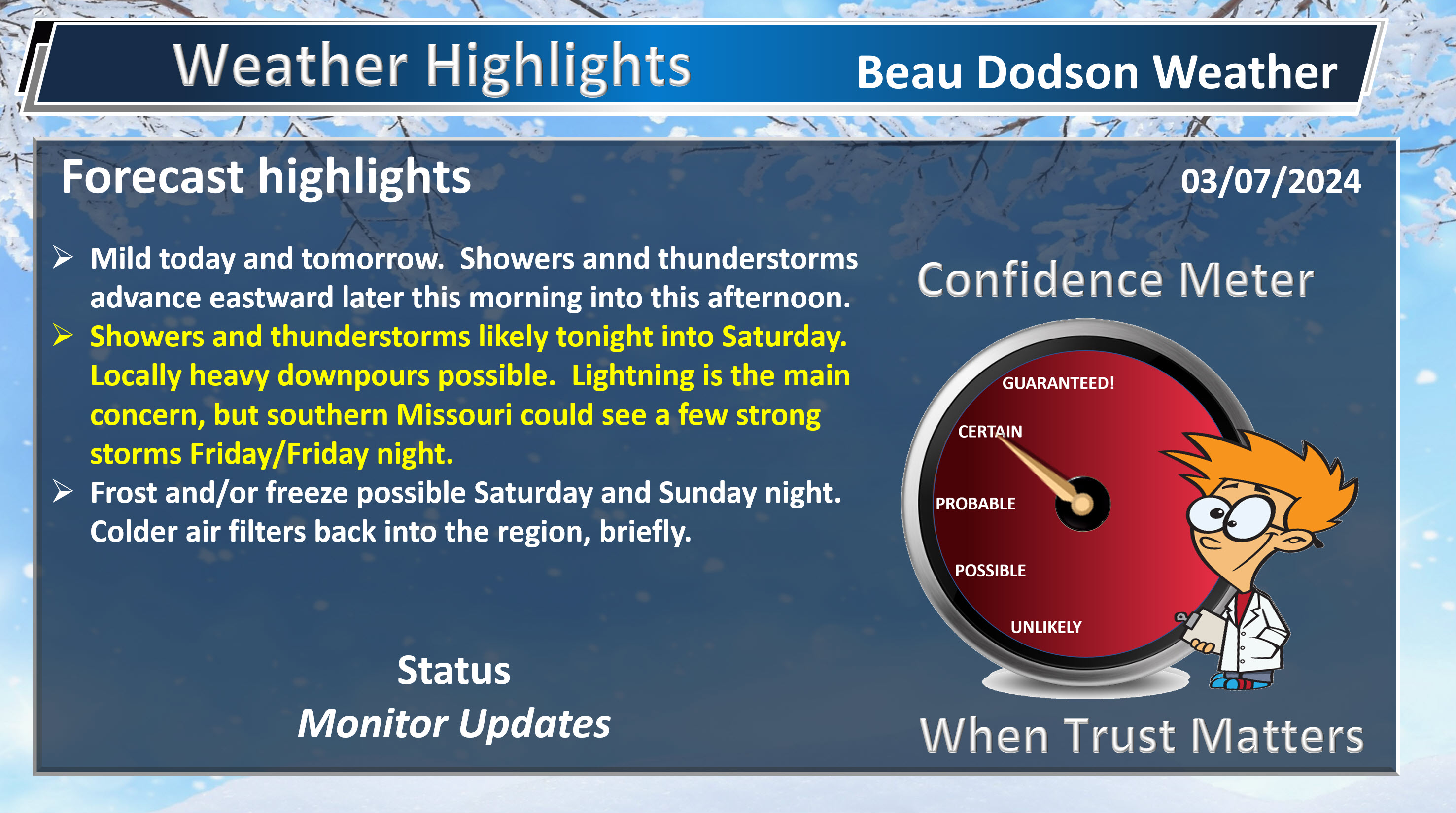
- Mild weather to continue through Friday.
- Showers and thunderstorms chances ramp back up this afternoon over southeast Missouri spreading east northeast tonight into Saturday.
- Colder air arrives Saturday evening into Sunday night. Frost and/or freeze conditions will be possible.
Weather advice:
Do you have any suggestions or comments? Email me at beaudodson@usawx.com
Make sure you have three to five ways of receiving your severe weather information.
.
Beau’s Forecast Discussion
Don’t forget we spring FORWARD this weekend! Sunday morning. Not everyone is a fan of the time change, but at least we gain an hour of daylight.

A storm system is advancing into the region this morning.
Let’s look at the 6 am radars. See the live radars for the most up to date imagery.
You can see showers and thunderstorms moving east northeast through Missouri and Arkansas.
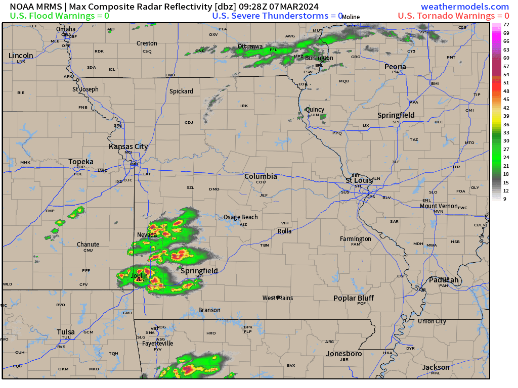
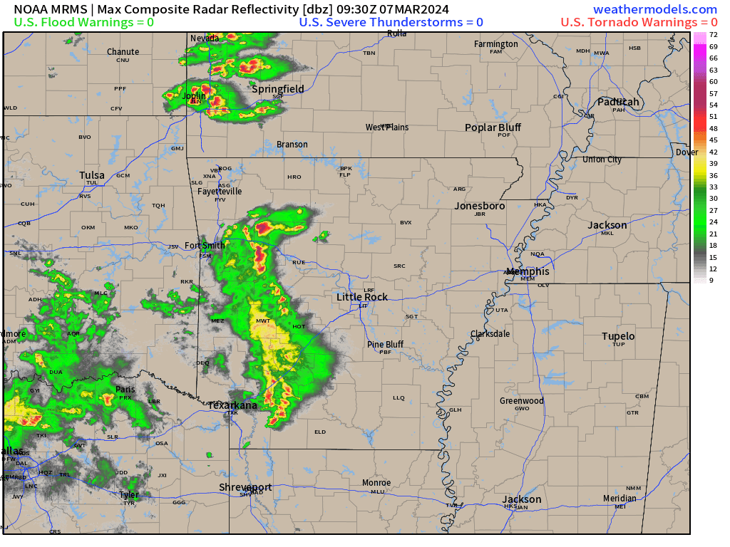
All of that activity will advance into our region over the coming 12 to 24 hours.
Showers and thunderstorms have sped up by three or four hours today. That means showers and storms will arrive in southeast Missouri this morning and then move east northeast into the region this afternoon and evening.
Numerous showers and thunderstorms will be possible tonight into Saturday. On and off rain. It won’t rain the entire time, but there will be precipitation on radar just about the entire time.
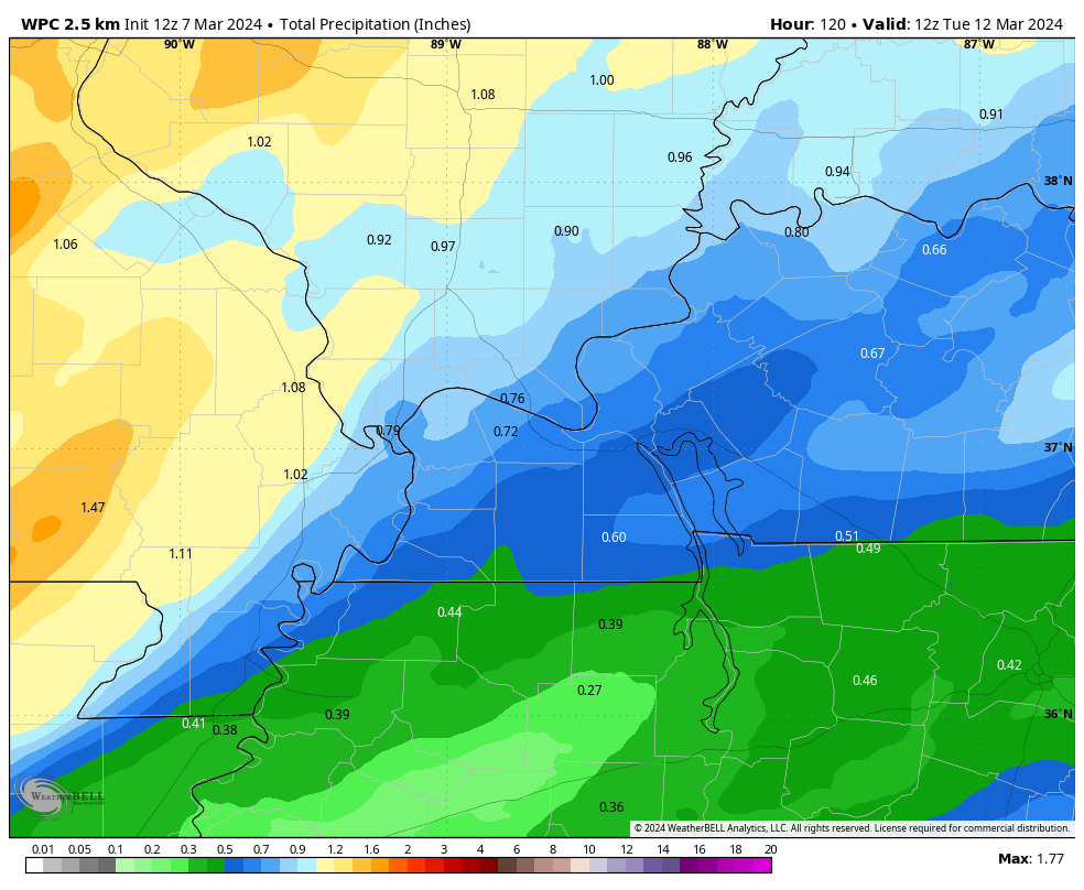
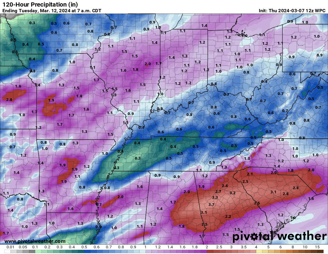
My rainfall forecast has been lowered to 0.55″ to 1.10″. My previous forecast was 0.70″ to 1.40″.
WPC has dropped their totals over mainly KY/TN. See graphic below.
Precipitation Coverage Forecast
The coverage will be greatest today and tonight over southeast Missouri and southern Illinois. Lower coverage over Kentucky and Tennessee.
Scattered coverage Friday over the area.
Widespread coverage area-wide Friday night/Saturday morning.
Becoming scattered Saturday morning into afternoon.
Precipitation ending Saturday afternoon/evening.
Rainfall totals have dropped a bit. Especially over our southeast counties. These adjustments aren’t unusual. We have witnessed this quite a bit over the past year or two.
We are in drought. Thus, we need rain.
Here are the latest rainfall totals forecast.
Double click images to enlarge.
The WPC even has placed our region in a low end risk of flooding. Overall, this looks like a nuisance type flooding event.
If thunderstorms train over the same area, then the risk for a flash flood warning would increase. Similar to the other days event.
The green zone is a level one flood risk.
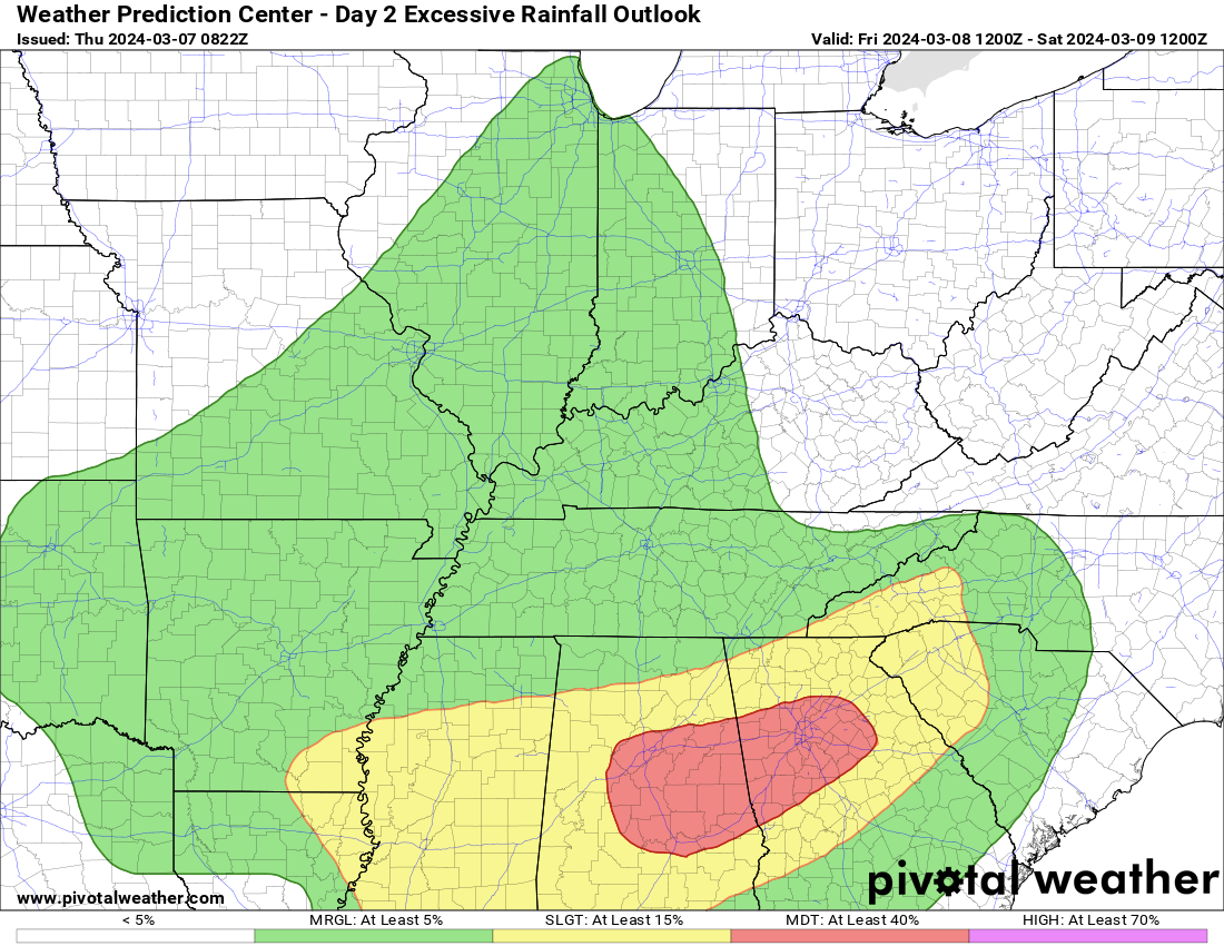
The Storm Prediction Center has placed portions of the region in a level one severe weather risk Friday and Friday night.
The light green zone is where thunderstorms are possible, but sub severe. The dark green zone is where thunderstorms are possible, but with a risk of large hail and strong wind gusts. We aren’t looking at a tornado risk.
Overall, the actual risk of severe weather is limited. There is discussion among local forecasters as to whether there is a risk at all.
Let’s keep an eye on it. The SPC will update this graphic several more times between now and Friday/Friday night. It is possible they shunt the risk farther south.
This would be for Friday and Friday night.

Shower and thunderstorm chances will continue into Saturday, but will begin to taper west to east as we move through the day.
It now appears that rain chances Saturday night will be less than 20%. Perhaps dry. If rain were to continue into Saturday night it would likely end before 6 PM.
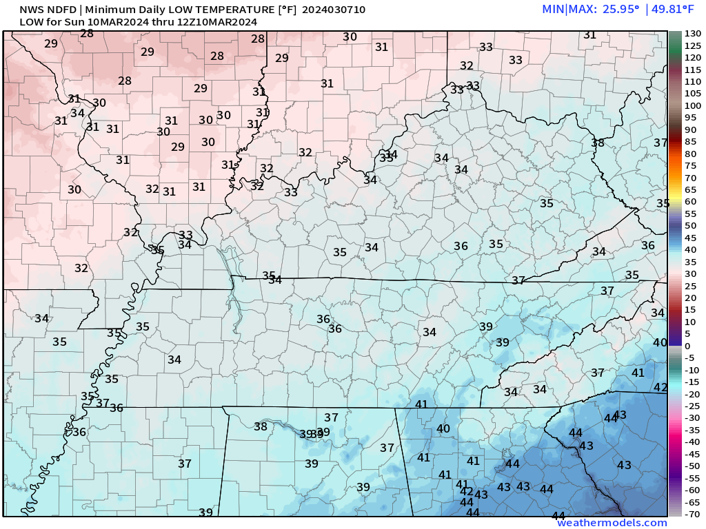
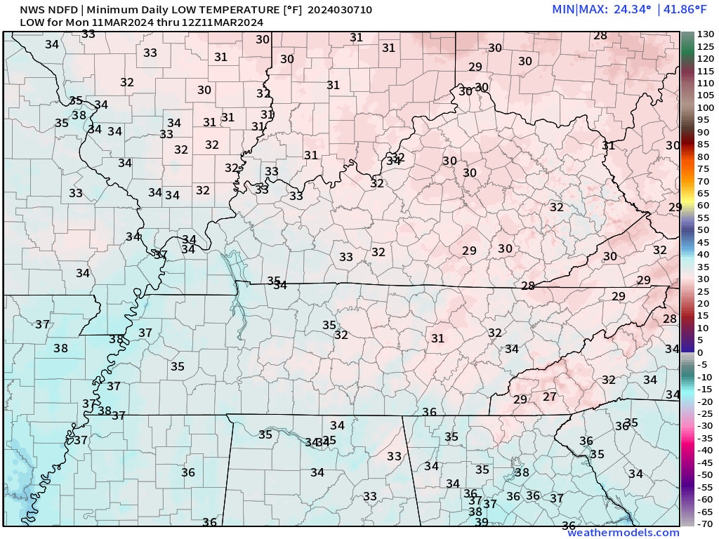
It will turn colder Saturday into Monday morning. Frost and freeze conditions are possible Saturday and Sunday night.
Frost won’t occur if winds don’t subside Saturday night/Sunday morning. If the wind does subside, then frost chances increase.
Frost would be more likely Sunday night. Winds will drop a bit. Temperatures will fall into the 30s.
Dry conditions Monday and Tuesday. A slow warming trend into next week.
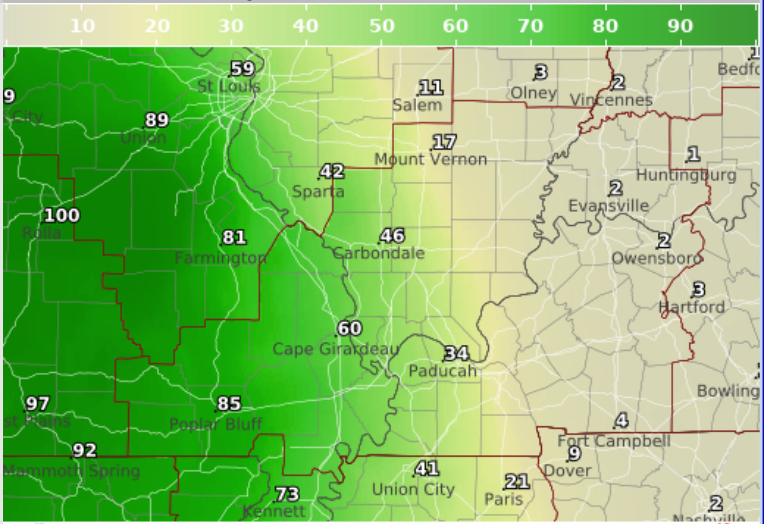
Sunday morning lows
Monday morning lows
![]()
.
Click here if you would like to return to the top of the page.
This outlook covers southeast Missouri, southern Illinois, western Kentucky, and far northwest Tennessee.

.
Today’s Storm Prediction Center’s (SPC) Severe Weather Outlook
Light green is where thunderstorms may occur but should be below severe levels.
Dark green is a level one risk. Yellow is a level two risk. Orange is a level three (enhanced) risk. Red is a level four (moderate) risk. Pink is a level five (high) risk.
One is the lowest risk. Five is the highest risk.
A severe storm is one that produces 58 mph wind or higher, quarter or larger size hail, and/or a tornado.
Explanation of tables. Click here.
Day One Severe Weather Outlook

Day One Severe Weather Outlook. Zoomed in on our region.

.
Day One Tornado Probability Outlook

Day One Regional Tornado Outlook. Zoomed in on our region.

.
Day One Large Hail Probability Outlook

Day One Regional Hail Outlook. Zoomed in on our region.

.
Day One High wind Probability Outlook

Day One Regional Wind Outlook. Zoomed in on our region.

.
Tomorrow’s severe weather outlook. Day two outlook.
Day Two Outlook. Zoomed in on our region.

.
Day Three Severe Weather Outlook

.

.
The images below are from NOAA’s Weather Prediction Center.
24-hour precipitation outlook..
 .
.
.
48-hour precipitation outlook.
. .
.
![]()
_______________________________________
.

Click here if you would like to return to the top of the page.
Again, as a reminder, these are models. They are never 100% accurate. Take the general idea from them.
What should I take from these?
- The general idea and not specifics. Models usually do well with the generalities.
- The time-stamp is located in the upper left corner.
.
What am I looking at?
You are looking at computer model data. Meteorologists use many different models to forecast the weather.
Occasionally, these maps are in Zulu time. 12z=7 AM. 18z=1 PM. 00z=7 PM. 06z=1 AM
Green represents light rain. Dark green represents moderate rain. Yellow and orange represent heavier rain.
.
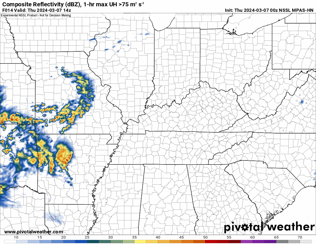
This animation is the NSSL MPAS Model.
Occasionally, these maps are in Zulu time. 12z=6 AM. 18z=12 PM. 00z=6 PM. 06z=12 AM
Double click images to enlarge them. Blue is snow. Pink is a wintry mix. Green is rain.
.
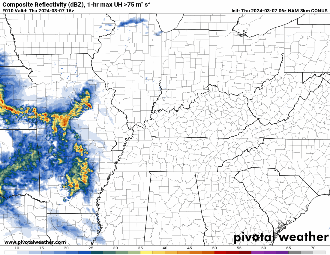
This animation is the NAM 3K Model.
Occasionally, these maps are in Zulu time. 12z=6 AM. 18z=12 PM. 00z=6 PM. 06z=12 AM
Double click images to enlarge them.
.
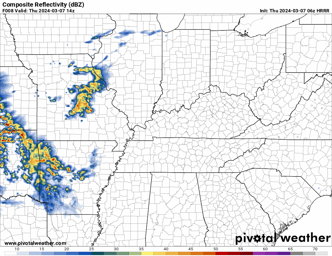
This animation is the HRRR Model.
Green is rain. Yellow and orange are heavier rain. Pink is a wintry mix. Blue is snow. Dark blue is heavier snow.
Occasionally, these maps are in Zulu time. 12z=6 AM. 18z=12 PM. 00z=6 PM. 06z=12 AM
Double click images to enlarge them.
.
This animation is the EC Model.
Green is rain. Yellow and orange are heavier rain. Pink is a wintry mix. Blue is snow. Dark blue is heavier snow.
Occasionally, these maps are in Zulu time. 12z=6 AM. 18z=12 PM. 00z=6 PM. 06z=12 AM
Double click images to enlarge them.
..![]()

.
Click here if you would like to return to the top of the page.
.Average high temperatures for this time of the year are around 56 degrees.
Average low temperatures for this time of the year are around 36 degrees.
Average precipitation during this time period ranges from 0.60″ to 1.20″
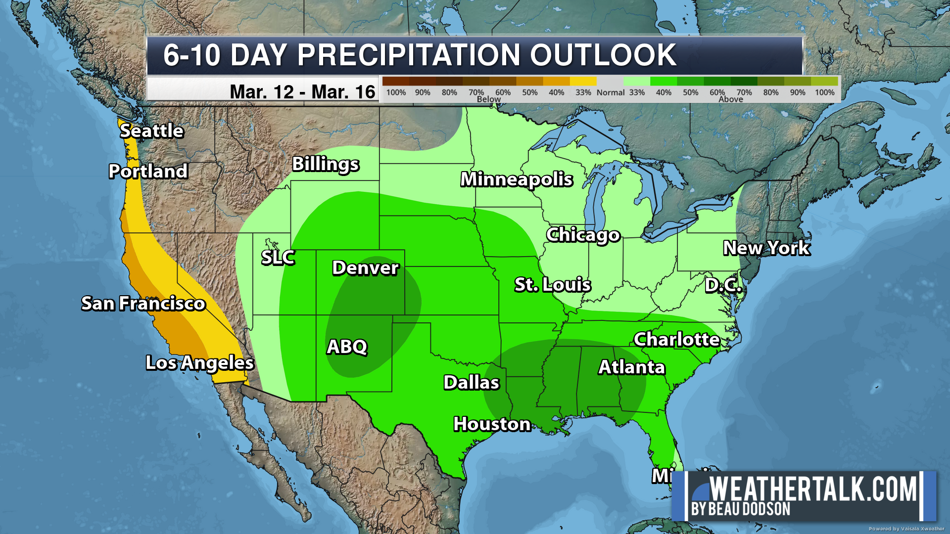
Six to Ten Day Outlook.
Blue is below average. Red is above average. The no color zone represents equal chances.
Average highs for this time of the year are in the lower 60s. Average lows for this time of the year are in the lower 40s.
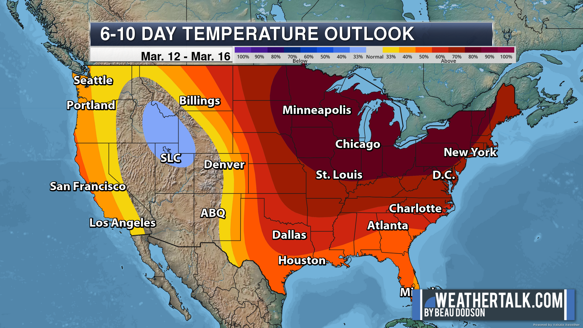
Green is above average precipitation. Yellow and brown favors below average precipitation. Average precipitation for this time of the year is around one inch per week.
.

Average low temperatures for this time of the year are around 38 degrees.
Average precipitation during this time period ranges from 0.60″ to 1.20″
.
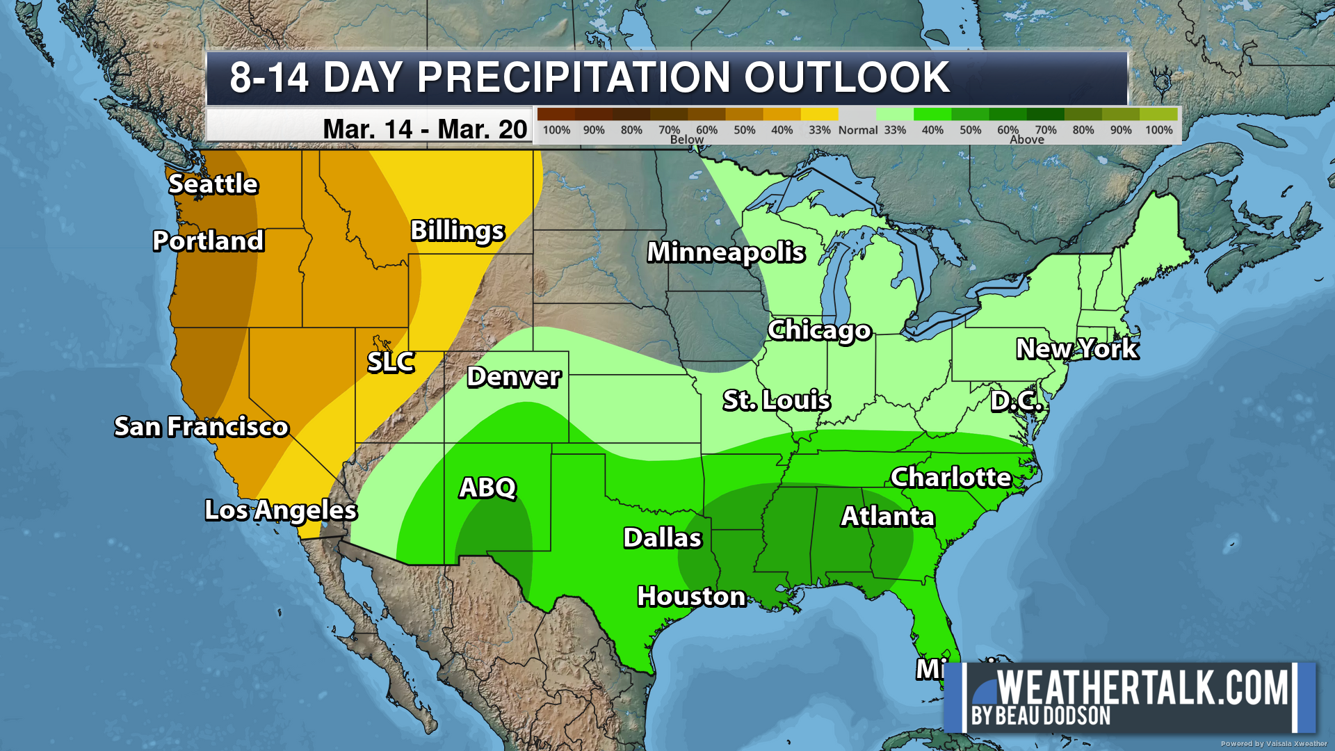
Eight to Fourteen Day Outlook.
Blue is below average. Red is above average. The no color zone represents equal chances.
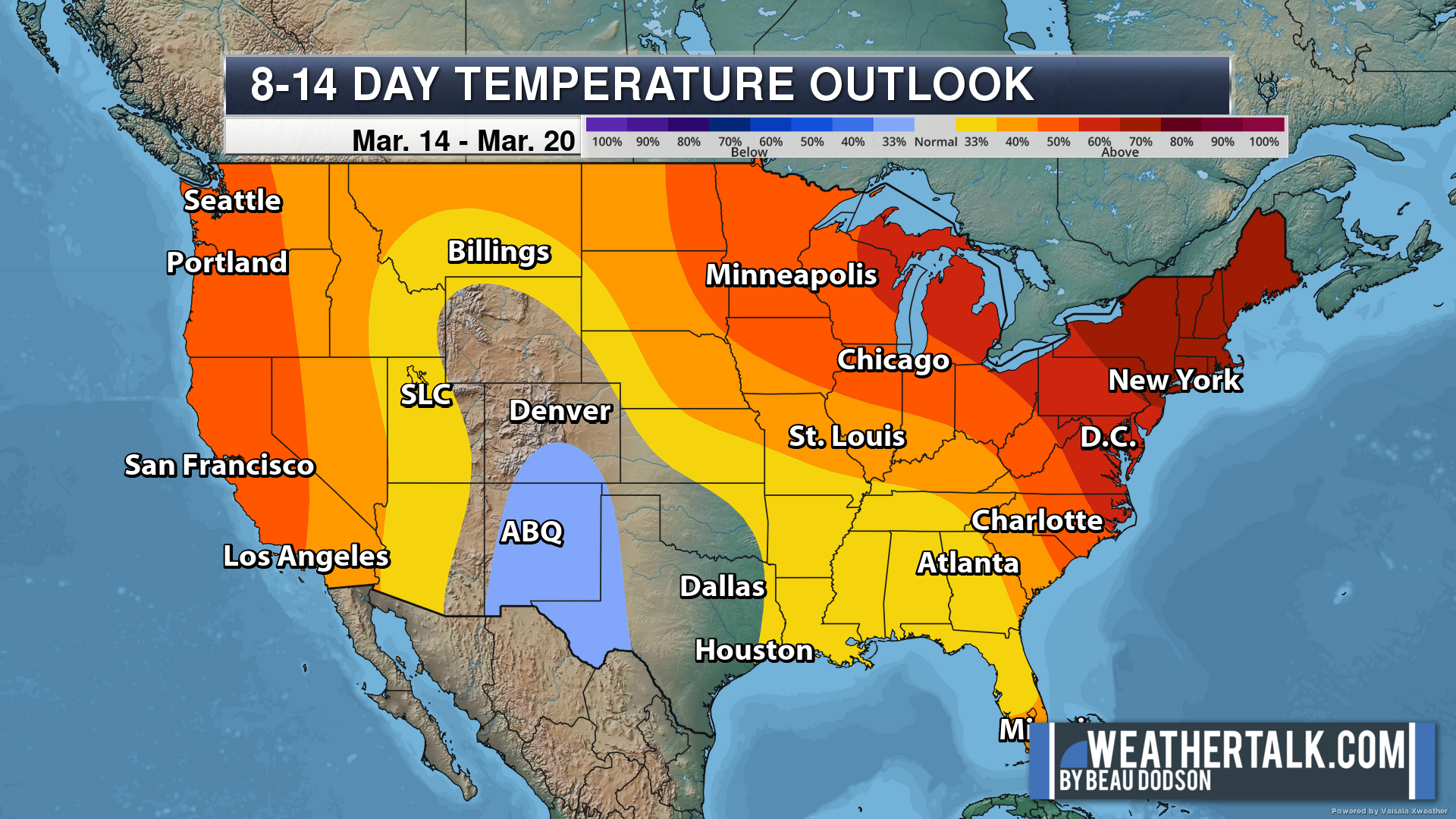
Green is above average precipitation. Yellow and brown favors below average precipitation. Average precipitation for this time of the year is around one inch per week.
.
![]()
The app is for subscribers. Subscribe at www.weathertalk.com/welcome then go to your app store and search for WeatherTalk
Subscribers, PLEASE USE THE APP. ATT and Verizon are not reliable during severe weather. They are delaying text messages.
The app is under WeatherTalk in the app store.

Apple users click here

Android users click here
.

Radars and Lightning Data
Interactive-city-view radars. Clickable watches and warnings.
https://wtalk.co/B3XHASFZ
If the radar is not updating then try another one. If a radar does not appear to be refreshing then hit Ctrl F5. You may also try restarting your browser.
Backup radar site in case the above one is not working.
https://weathertalk.com/morani
Regional Radar
https://imagery.weathertalk.com/prx/RadarLoop.mp4
** NEW ** Zoom radar with chaser tracking abilities!
ZoomRadar
Lightning Data (zoom in and out of your local area)
https://wtalk.co/WJ3SN5UZ
Not working? Email me at beaudodson@usawx.com
National map of weather watches and warnings. Click here.
Storm Prediction Center. Click here.
Weather Prediction Center. Click here.
.

Live lightning data: Click here.
Real time lightning data (another one) https://map.blitzortung.org/#5.02/37.95/-86.99
Our new Zoom radar with storm chases
.
.

Interactive GOES R satellite. Track clouds. Click here.
GOES 16 slider tool. Click here.
College of DuPage satellites. Click here
.

Here are the latest local river stage forecast numbers Click Here.
Here are the latest lake stage forecast numbers for Kentucky Lake and Lake Barkley Click Here.
.
.
Find Beau on Facebook! Click the banner.


 .
.