
Click one of the links below to take you directly to that section
![]()
![]()
![]()
![]()
![]()
![]()
![]()
.

.
Seven Day Hazardous Weather Outlook
1. Is lightning in the forecast? YES. Lightning is likely Thursday night into at least Friday night and perhaps some Saturday, as well.
2. Are severe thunderstorms in the forecast? MONITOR. I am watchin southern Missouri Friday and Friday night. We will have to see if the risk spreads farther east northeast. For now, a few storms could produce hail and wind over southern Missouri. The rest of the area has a lightning threat.
3. Is flash flooding in the forecast? ISOLATED ISSUES. Rain is likely again Thursday night into Saturday. Some low-land flooding will be possible. Standing water in ditches and fields. Avoid flooded roadways. Rain totals today will range from 0 to over two inches.
4. Will non-thunderstorm winds top 40 mph? NO.
5. Will the heat index exceed 100 degrees? NO.
6. Will the wind chill dip below 10 degrees? NO.
7. Is measurable snow and/or sleet in the forecast? NO.
8. Is freezing rain/ice in the forecast? NO.
Freezing rain is rain that falls and instantly freezes on objects such as trees and power lines Freezing fog possible, as well.
.
BEAU’S STORM TRACKING RADARS
Interactive-city-view radars. Clickable watches and warnings.
https://wtalk.co/B3XHASFZ
If the radar is not updating then try another one. If a radar does not appear to be refreshing then hit Ctrl F5. You may also try restarting your browser.
Backup radar site in case the above one is not working.
https://weathertalk.com/morani
Regional Radar
https://imagery.weathertalk.com/prx/RadarLoop.mp4
** NEW ** Zoom radar with chaser tracking abilities!
ZoomRadar
.

Fire weather risk level.
Wednesday: 4. Low risk.
Wednesday night: 4. Low risk.
Thursday: 4. Low risk.
Fire Weather Discussion
Low clouds will struggle to clear today, so despite a decent northerly transport wind, poor dispersion is expected. While mixing will be decent on Thursday, transport winds will be rather light switching from easterly to southerly through the day. This will lead to poor dispersion again. Rain chances increase late Thursday into Thursday night and continue off and on through Saturday. Widespread rainfall amounts of 1 to 1.5 inches are anticipated. Good drying conditions are expected Sunday through next Tuesday with minimum RH values lowering into the 30 to 40 percent range. Could see readings a bit lower in the Ozark Foothills on Sunday afternoon. Northwest winds this weekend will switch around to the southwest on Monday and southerly by next Tuesday.
A Haines Index of 6 means a high potential for an existing fire to become large or exhibit erratic fire behavior, 5 means medium potential, 4 means low potential, and anything less than 4 means very low potential.
Seven-day forecast for southeast Missouri, southern Illinois, western Kentucky, and western Tennessee.
This is a BLEND for the region. Scroll down to see the region by region forecast.
.

THE FORECAST IS GOING TO VARY FROM LOCATION TO LOCATION. Scroll down to see your local forecast details.
48-hour forecast Graphics


.
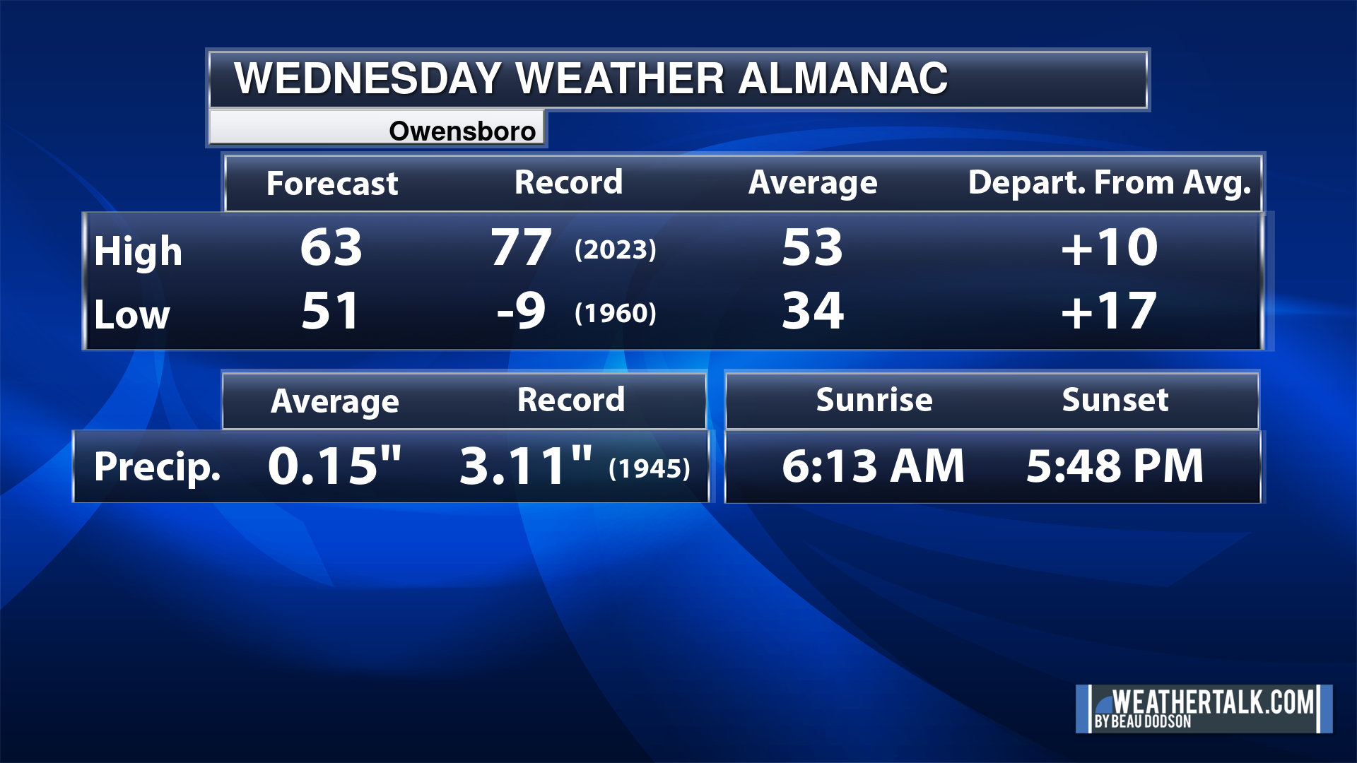
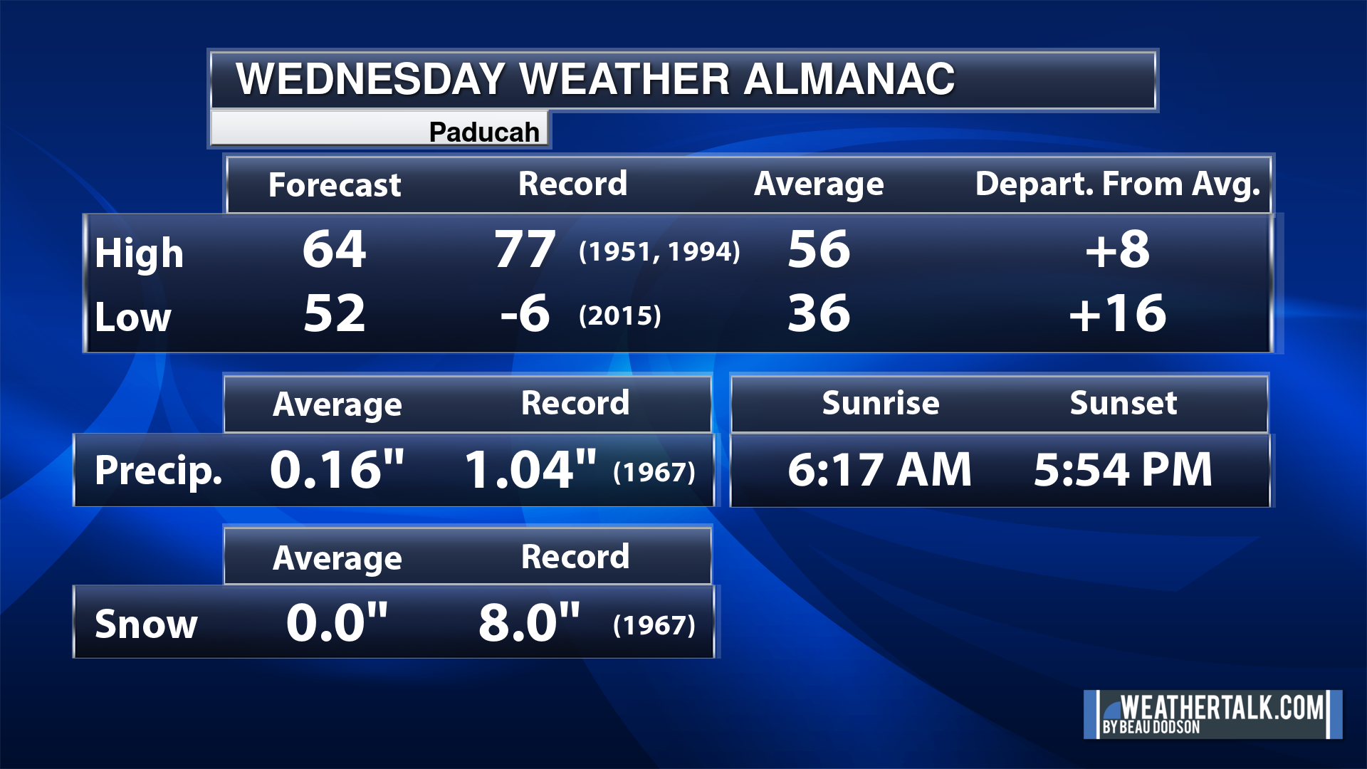
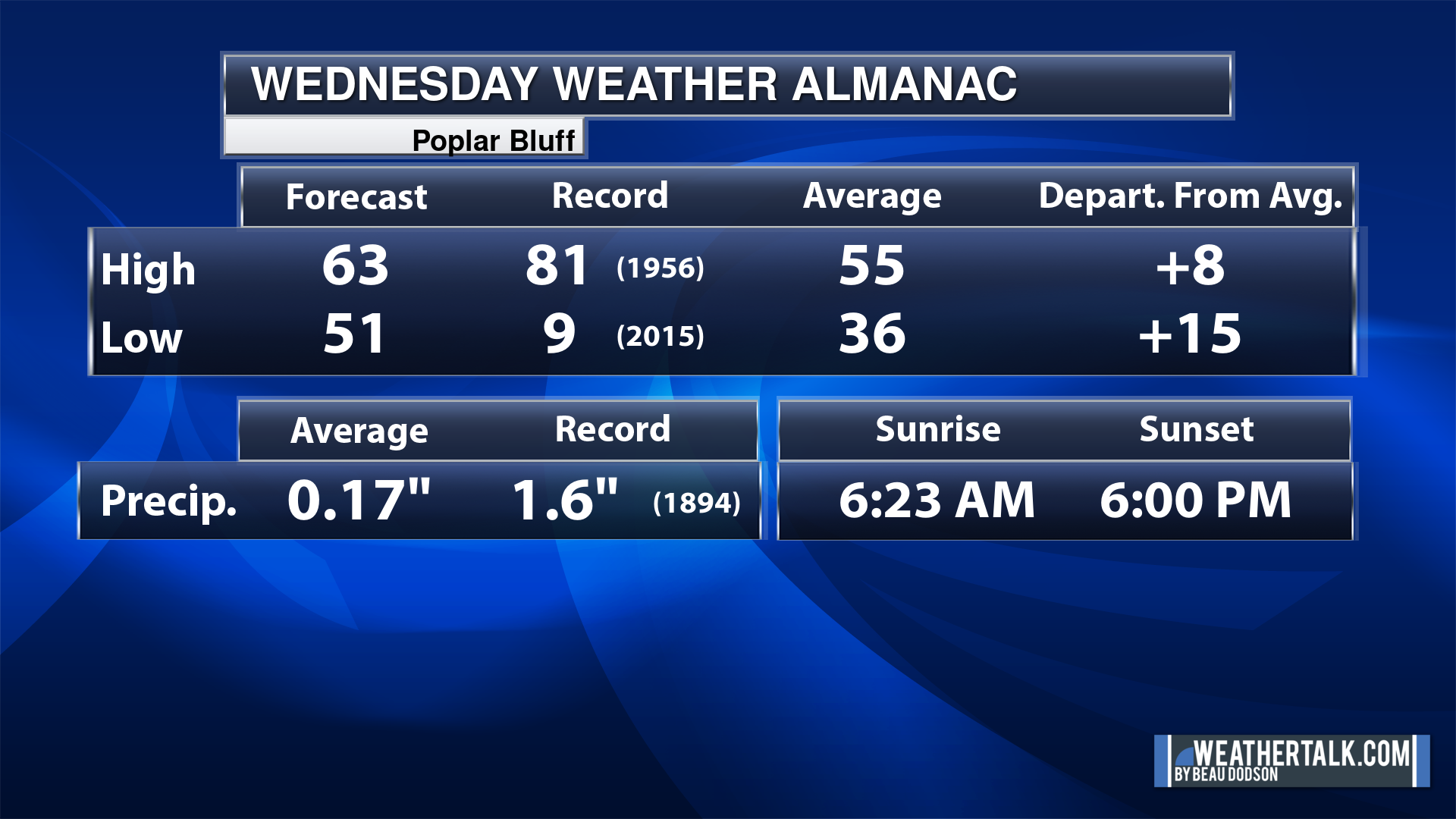
Today’s Local Almanacs (for a few select cities). Your location will be comparable.
Note, the low is this morning’s low and not tomorrows.
The forecast temperature shows you today’s expected high and this morning’s low.
The graphic shows you the record high and record low for today. It shows you what year that occurred, as well.
It then shows you what today’s average temperature is.
It shows you the departures (how may degrees above or below average temperatures will be ).
It shows you the average precipitation for today. Average comes from thirty years of rain totals.
It also shows you the record rainfall for the date and what year that occurred.
The sunrise and sunset are also shown.


![]()
.
.
Wednesday Forecast: Intervals of clouds. Stratus clouds can be difficult to scour out. Patchy drizzle where clouds are thickest. There is a chance the clouds thin a bit over at least southeast Missouri and southwest Illinois. Clouds may linger longer east of the MS River. A range of temperatures depending on cloud cover.
What is the chance of precipitation?
Far northern southeast Missouri ~ 10%
Southeast Missouri ~ 10%
The Missouri Bootheel ~ 10%
I-64 Corridor of southern Illinois ~ 10%
Southern Illinois ~ 10%
Extreme southern Illinois (southern seven counties) ~ 20%
Far western Kentucky (Purchase area) ~ 20%
The Pennyrile area of western KY ~ 20%
Northwest Kentucky (near Indiana border) ~ 20%
Northwest Tennessee ~ 20%
Coverage of precipitation: Scattered drizzle
Timing of the precipitation: Any given point of time.
Far northern southeast Missouri ~ 60° to 62°
Southeast Missouri ~ 58° to 62°
The Missouri Bootheel ~ 60° to 64°
I-64 Corridor of southern Illinois ~ 58° to 60°
Southern Illinois ~ 55° to 60°
Extreme southern Illinois (southern seven counties) ~ 56° to 62°
Far western Kentucky ~ 55° to 60°
The Pennyrile area of western KY ~ 55° to 60°
Northwest Kentucky (near Indiana border) ~ 55° to 60°
Northwest Tennessee ~ 58° to 60°
Winds will be from this direction: North northeast 10 to 20 mph.
Wind chill or heat index (feels like) temperature forecast: 52° to 62°
What impacts are anticipated from the weather? Wet roadways.
Should I cancel my outdoor plans? No, but monitor updates.
UV Index: 4. Moderate.
Sunrise: 6:18 AM
Sunset: 5:55 PM .
.
Wednesday Night Forecast: Intervals of clouds. A chance of patchy drizzle over mainly southeast Illinois and western Kentucky. Northwest Tennessee, as well.
What is the chance of precipitation?
Far northern southeast Missouri ~ 10%
Southeast Missouri ~ 10%
The Missouri Bootheel ~ 10%
I-64 Corridor of southern Illinois ~ 20%
Southern Illinois ~ 20%
Extreme southern Illinois (southern seven counties) ~ 20%
Far western Kentucky (Purchase area) ~ 30%
The Pennyrile area of western KY ~ 30%
Northwest Kentucky (near Indiana border) ~ 30%
Northwest Tennessee ~ 30%
Coverage of precipitation: Scattered
Timing of the precipitation: Any given point of time
Temperature range:
Far northern southeast Missouri ~ 49° to 42°
Southeast Missouri ~ 40° to 42°
The Missouri Bootheel ~ 40° to 44°
I-64 Corridor of southern Illinois ~ 40° to 44°
Southern Illinois ~ 44° to 48°
Extreme southern Illinois (southern seven counties) ~ 42° to 44°
Far western Kentucky ~ 43° to 46°
The Pennyrile area of western KY ~ 48° to 50°
Northwest Kentucky (near Indiana border) ~ 43° to 46°
Northwest Tennessee ~ 45° to 50°
Winds will be from this direction: Northeast 7 to 14 mph.
Wind chill or heat index (feels like) temperature forecast: 38° to 48°
What impacts are anticipated from the weather? Wet roadways
Should I cancel my outdoor plans? No
Moonrise: 4:04 AM
Moonset: 1:29 PM
The phase of the moon: Waning Crescent
.
Thursday Forecast: Thickening clouds.
What is the chance of precipitation?
Far northern southeast Missouri ~ 30%
Southeast Missouri ~ 40%
The Missouri Bootheel ~ 30%
I-64 Corridor of southern Illinois ~ 20%
Southern Illinois ~ 20%
Extreme southern Illinois (southern seven counties) ~ 10%
Far western Kentucky (Purchase area) ~ 10%
The Pennyrile area of western KY ~ 0%
Northwest Kentucky (near Indiana border) ~ 0%
Northwest Tennessee ~ 10%
Coverage of precipitation: Widely scattered. Mainly late in the day over SE MO
Timing of the precipitation: After 3 PM
Far northern southeast Missouri ~ 60° to 62°
Southeast Missouri ~ 62° to 64°
The Missouri Bootheel ~ 62° to 64°
I-64 Corridor of southern Illinois ~ 58° to 62°
Southern Illinois ~ 60° to 62°
Extreme southern Illinois (southern seven counties) ~ 60° to 62°
Far western Kentucky ~ 62° to 65°
The Pennyrile area of western KY ~ 64° to 68°
Northwest Kentucky (near Indiana border) ~ 62° to 65°
Northwest Tennessee ~ 64° to 68°
Winds will be from this direction: Southeast at 7 to 14 mph. Higher gusts possible.
Wind chill or heat index (feels like) temperature forecast: 55° to 60°
What impacts are anticipated from the weather?
Should I cancel my outdoor plans? No
UV Index: 2. Low.
Sunrise: 6:17 PM
Sunset: 5:58 PM .
.
Thursday Night Forecast: Mostly cloudy with a chance of showers. A thunderstorm will be possible.
What is the chance of precipitation?
Far northern southeast Missouri ~ 80%
Southeast Missouri ~ 80%
The Missouri Bootheel ~ 80%
I-64 Corridor of southern Illinois ~ 80%
Southern Illinois ~ 80%
Extreme southern Illinois (southern seven counties) ~ 80%
Far western Kentucky (Purchase area) ~ 80%
The Pennyrile area of western KY ~ 80%
Northwest Kentucky (near Indiana border) ~ 80%
Northwest Tennessee ~ 80%
Coverage of precipitation: Numerous
Timing of the precipitation: Any given point of time.
Temperature range:
Far northern southeast Missouri ~ 50° to 54°
Southeast Missouri ~ 50° to 54°
The Missouri Bootheel ~ 50° to 54°
I-64 Corridor of southern Illinois ~ 50° to 54°
Southern Illinois ~ 52° to 54°
Extreme southern Illinois (southern seven counties) ~ 52° to 54°
Far western Kentucky ~ 52° to 54°
The Pennyrile area of western KY ~ 52° to 55°
Northwest Kentucky (near Indiana border) ~ 50° to 54°
Northwest Tennessee ~ 52° to 55°
Winds will be from this direction: Southeast at 7 to 14 mph.
Wind chill or heat index (feels like) temperature forecast: 46° to 52°
What impacts are anticipated from the weather? Wet roadways. I will monitor the risk of lightning.
Should I cancel my outdoor plans? No, but monitor updates and radars.
Moonrise: 4:50 AM
Moonset: 2:49 PM
The phase of the moon: Waning Crescent
.
Friday Forecast: Mostly cloudy. A chance of showers and thunderstorms.
What is the chance of precipitation?
Far northern southeast Missouri ~ 80%
Southeast Missouri ~ 80%
The Missouri Bootheel ~ 80%
I-64 Corridor of southern Illinois ~ 80%
Southern Illinois ~ 90%
Extreme southern Illinois (southern seven counties) ~ 90%
Far western Kentucky (Purchase area) ~ 90%
The Pennyrile area of western KY ~ 90%
Northwest Kentucky (near Indiana border) ~ 80%
Northwest Tennessee ~ 90%
Coverage of precipitation: Numerous
Timing of the precipitation: Any given point of time.
Far northern southeast Missouri ~ 62° to 65°
Southeast Missouri ~ 62° to 65°
The Missouri Bootheel ~ 64° to 68°
I-64 Corridor of southern Illinois ~ 62° to 64°
Southern Illinois ~ 62° to 64°
Extreme southern Illinois (southern seven counties) ~ 62° to 65°
Far western Kentucky ~ 64° to 68°
The Pennyrile area of western KY ~64° to 68°
Northwest Kentucky (near Indiana border) ~ 64° to 68°
Northwest Tennessee ~ 64° to 68°
Winds will be from this direction: South southwest t0 to 25 mph.
Wind chill or heat index (feels like) temperature forecast: 58° to 64°
What impacts are anticipated from the weather? Wet roadways. Lightning.
Should I cancel my outdoor plans? Have a plan B. Monitor updates and the Beau Dodson Weather Radars.
UV Index: 2. Low.
Sunrise: 6:16 PM
Sunset: 5:57 PM .
.
Friday Night Forecast: Mostly cloudy. A chance of showers and thunderstorms.
What is the chance of precipitation?
Far northern southeast Missouri ~ 80%
Southeast Missouri ~ 80%
The Missouri Bootheel ~ 90%
I-64 Corridor of southern Illinois ~ 80%
Southern Illinois ~ 80%
Extreme southern Illinois (southern seven counties) ~ 80%
Far western Kentucky (Purchase area) ~ 90%
The Pennyrile area of western KY ~ 90%
Northwest Kentucky (near Indiana border) ~ 80%
Northwest Tennessee ~ 90%
Coverage of precipitation: Numerous
Timing of the precipitation: Any given point of time.
Temperature range:
Far northern southeast Missouri ~ 38° to 42°
Southeast Missouri ~ 38° to 40°
The Missouri Bootheel ~ 42° to 44°
I-64 Corridor of southern Illinois ~ 38° to 42°
Southern Illinois ~ 38° to 42°
Extreme southern Illinois (southern seven counties) ~ 42° to 44°
Far western Kentucky ~ 42° to 44°
The Pennyrile area of western KY ~ 43° to 46°
Northwest Kentucky (near Indiana border) ~ 40° to 42°
Northwest Tennessee ~ 44° to 48°
Winds will be from this direction: West northwest 10 to 20 mph. Gusty.
Wind chill or heat index (feels like) temperature forecast: 34° to 44°
What impacts are anticipated from the weather? Wet roadways. Lightning.
Should I cancel my outdoor plans? No, but monitor updates and the Beau Dodson Weather Radars.
Moonrise: 5:30 AM
Moonset: 4:03 PM
The phase of the moon: Waning Crescent
.
Saturday Forecast: Mostly cloudy. A chance of showers and thunderstorms.
What is the chance of precipitation?
Far northern southeast Missouri ~ 40%
Southeast Missouri ~ 40%
The Missouri Bootheel ~ 40%
I-64 Corridor of southern Illinois ~ 40%
Southern Illinois ~ 60%
Extreme southern Illinois (southern seven counties) ~ 60%
Far western Kentucky (Purchase area) ~ 60%
The Pennyrile area of western KY ~ 60%
Northwest Kentucky (near Indiana border) ~ 60%
Northwest Tennessee ~ 60%
Coverage of precipitation: Scattered to numerous
Timing of the precipitation: Any given point of time.
Far northern southeast Missouri ~ 50° to 55°
Southeast Missouri ~ 52° to 55°
The Missouri Bootheel ~ 53° to 56°
I-64 Corridor of southern Illinois ~ 50° to 54°
Southern Illinois ~ 52° to 54°
Extreme southern Illinois (southern seven counties) ~ 53° to 56°
Far western Kentucky ~ 54° to 58°
The Pennyrile area of western KY ~ 55° to 60°
Northwest Kentucky (near Indiana border) ~ 53° to 65°
Northwest Tennessee ~ 53° to 56°
Winds will be from this direction: Northwest 10 to 25 mph.
Wind chill or heat index (feels like) temperature forecast: 48° to 58°
What impacts are anticipated from the weather? Wet roadways. Lightning.
Should I cancel my outdoor plans? Have a plan B. Monitor updates and the Beau Dodson Weather Radars.
UV Index: 2. Low.
Sunrise: 6:14 PM
Sunset: 5:58 PM .
.
Saturday Night Forecast: Mostly cloudy. Showers ending.
What is the chance of precipitation?
Far northern southeast Missouri ~ 10%
Southeast Missouri ~ 10%
The Missouri Bootheel ~ 10%
I-64 Corridor of southern Illinois ~ 20%
Southern Illinois ~ 20%
Extreme southern Illinois (southern seven counties) ~ 20%
Far western Kentucky (Purchase area) ~ 20%
The Pennyrile area of western KY ~ 20%
Northwest Kentucky (near Indiana border) ~ 20%
Northwest Tennessee ~ 20%
Coverage of precipitation: Ending
Timing of the precipitation: Before 6 PM
Temperature range:
Far northern southeast Missouri ~ 32° to 34°
Southeast Missouri ~ 33° to 36°
The Missouri Bootheel ~ 34° to 36°
I-64 Corridor of southern Illinois ~ 32° to 34°
Southern Illinois ~ 32° to 34°
Extreme southern Illinois (southern seven counties) ~ 32° to 34°
Far western Kentucky ~ 32° to 34°
The Pennyrile area of western KY ~ 34° to 36°
Northwest Kentucky (near Indiana border) ~ 32° to 35°
Northwest Tennessee ~ 34° to 38°
Winds will be from this direction: West northwest 10 to 20 mph. Gusty.
Wind chill or heat index (feels like) temperature forecast: 28° to 34°
What impacts are anticipated from the weather?
Should I cancel my outdoor plans? No
Moonrise: 6:02 AM
Moonset: 5:21 PM
The phase of the moon: Waning Crescent
.
Click here if you would like to return to the top of the page.

-
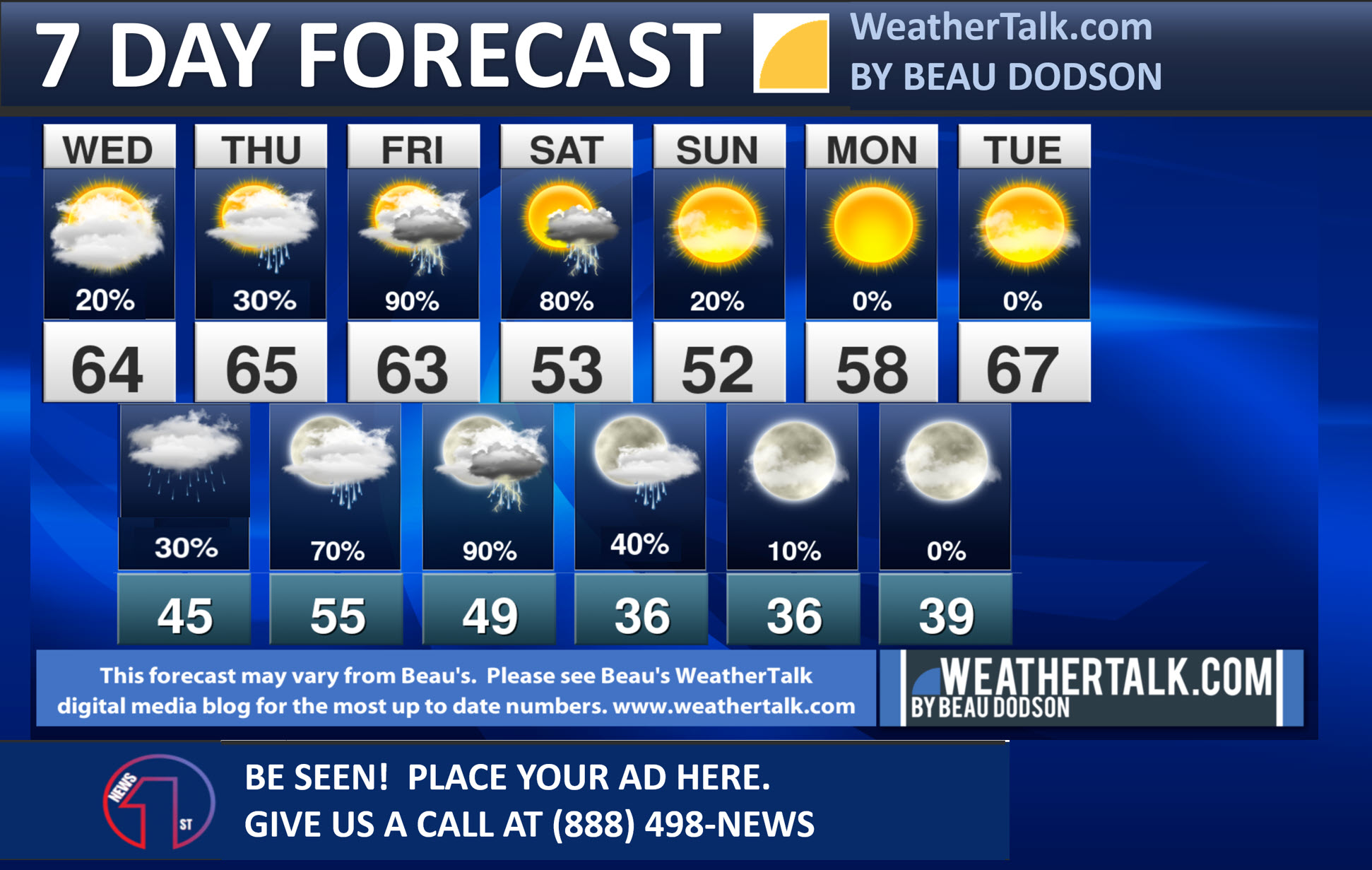
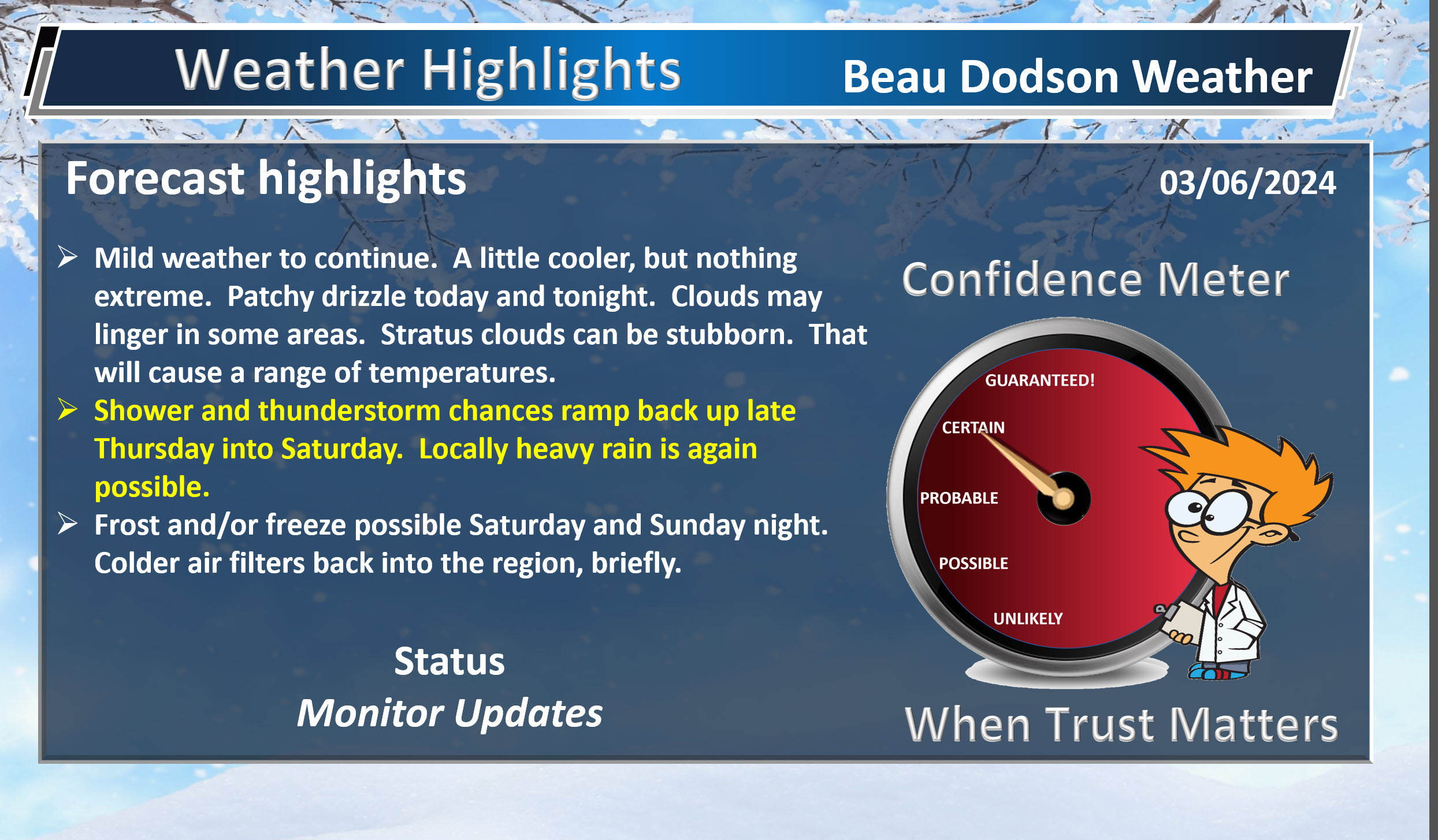
- Mild weather to continue through Friday.
- Showers and thunderstorms chances ramp back up late Thursday into Saturday.
- Colder air arrives Saturday into Sunday night. Frost and/or freeze conditions will be possible.
Weather advice:
Do you have any suggestions or comments? Email me at beaudodson@usawx.com
Make sure you have three to five ways of receiving your severe weather information.
.
Beau’s Forecast Discussion
Good morning, everyone
Well, the forecast was for 0″ to over 2″ of rain yesterday. Some of you missed out, but that was my forecast. A large range.
Some areas picked up more than three inches of rain! There was even a flash flood warning or two.
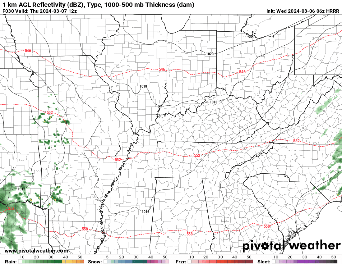
Double click the radar to see a larger image.
The heaviest rain fell across far southeast Missouri into southeast Illinois and then into northwest Kentucky.
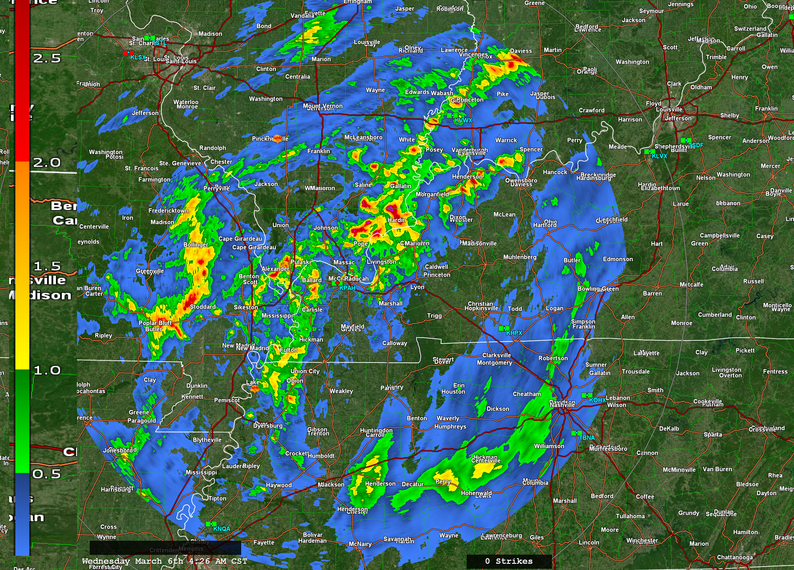
No severe thunderstorms. There were a few reports of small hail.
That system has pushed off to the southeast. The front has moved across the region. Clouds, however, will linger today.
Stratus clouds can be very difficult to scour out during the winter months. That will certainly be the case today into tonight. They can also produce drizzle.
Drizzle is possible today and tonight. The chance of drizzle will be higher east of the Mississippi River. Rain totals will be trace amounts.
No freezing drizzle. Temperatures will remain too warm.
No rest for the weatherman.
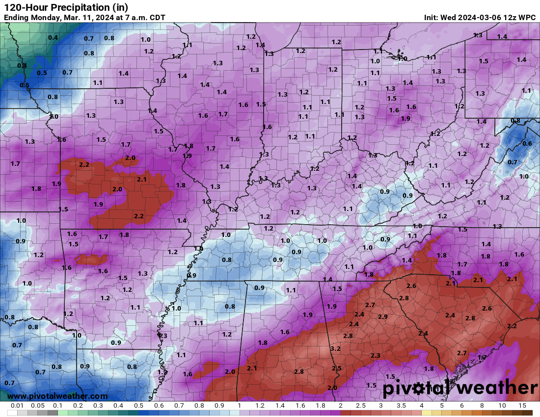
Our next storm system will arrive late Thursday over southeast Missouri. Showers and thunderstorm chances will ramp up Thursday evening into Saturday.
Widespread rain is likely. This time around, a general 0.7 to 1.4″ of rain is likely across most counties. Then, pockets of over two inches of rain Where thunderstorm enhance rain totals.
Here is the NOAA rainfall outlook for Thursday into Saturday.
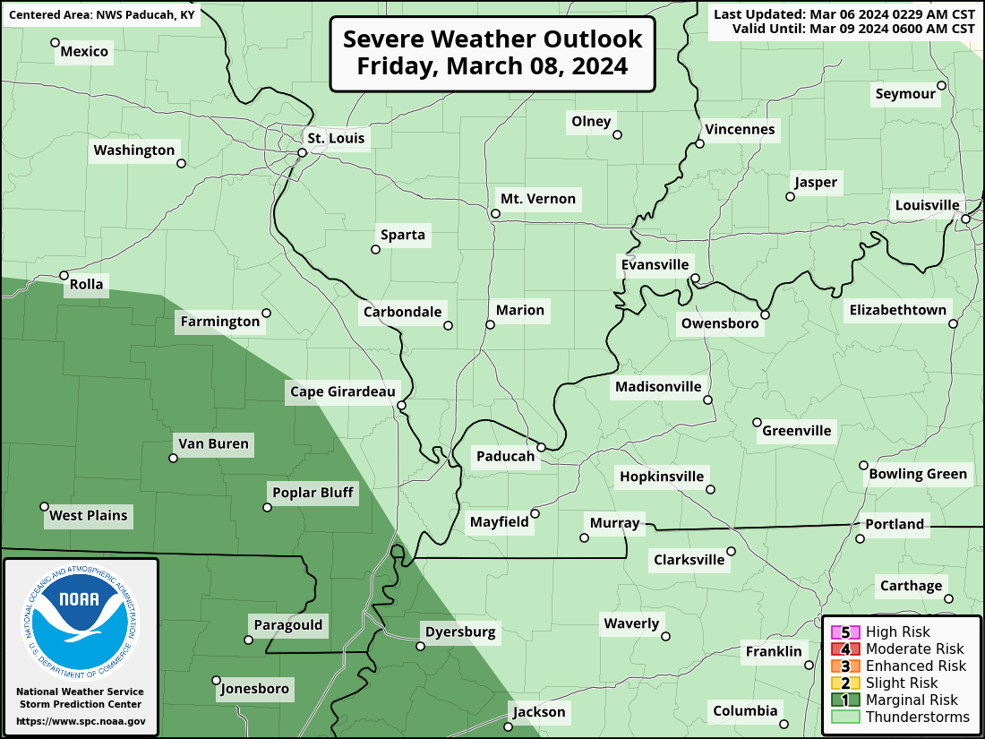
The Storm Prediction Center has placed southern Missouri in a marginal risk Friday and Friday night. Whether this spreads farther northeast will need to be monitored.
That system will come to an end Saturday afternoon and evening. Perhaps a few lingering showers Saturday night, but we should start to see the system move off to our east with colder air arriving.
A frost and or freeze will be possible Saturday night and Sunday night with lows in the 30s.
![]()
.
Click here if you would like to return to the top of the page.
This outlook covers southeast Missouri, southern Illinois, western Kentucky, and far northwest Tennessee.

.
Today’s Storm Prediction Center’s (SPC) Severe Weather Outlook
Light green is where thunderstorms may occur but should be below severe levels.
Dark green is a level one risk. Yellow is a level two risk. Orange is a level three (enhanced) risk. Red is a level four (moderate) risk. Pink is a level five (high) risk.
One is the lowest risk. Five is the highest risk.
A severe storm is one that produces 58 mph wind or higher, quarter or larger size hail, and/or a tornado.
Explanation of tables. Click here.
Day One Severe Weather Outlook

Day One Severe Weather Outlook. Zoomed in on our region.

.
Day One Tornado Probability Outlook

Day One Regional Tornado Outlook. Zoomed in on our region.

.
Day One Large Hail Probability Outlook

Day One Regional Hail Outlook. Zoomed in on our region.

.
Day One High wind Probability Outlook

Day One Regional Wind Outlook. Zoomed in on our region.

.
Tomorrow’s severe weather outlook. Day two outlook.

Day Two Outlook. Zoomed in on our region.

.
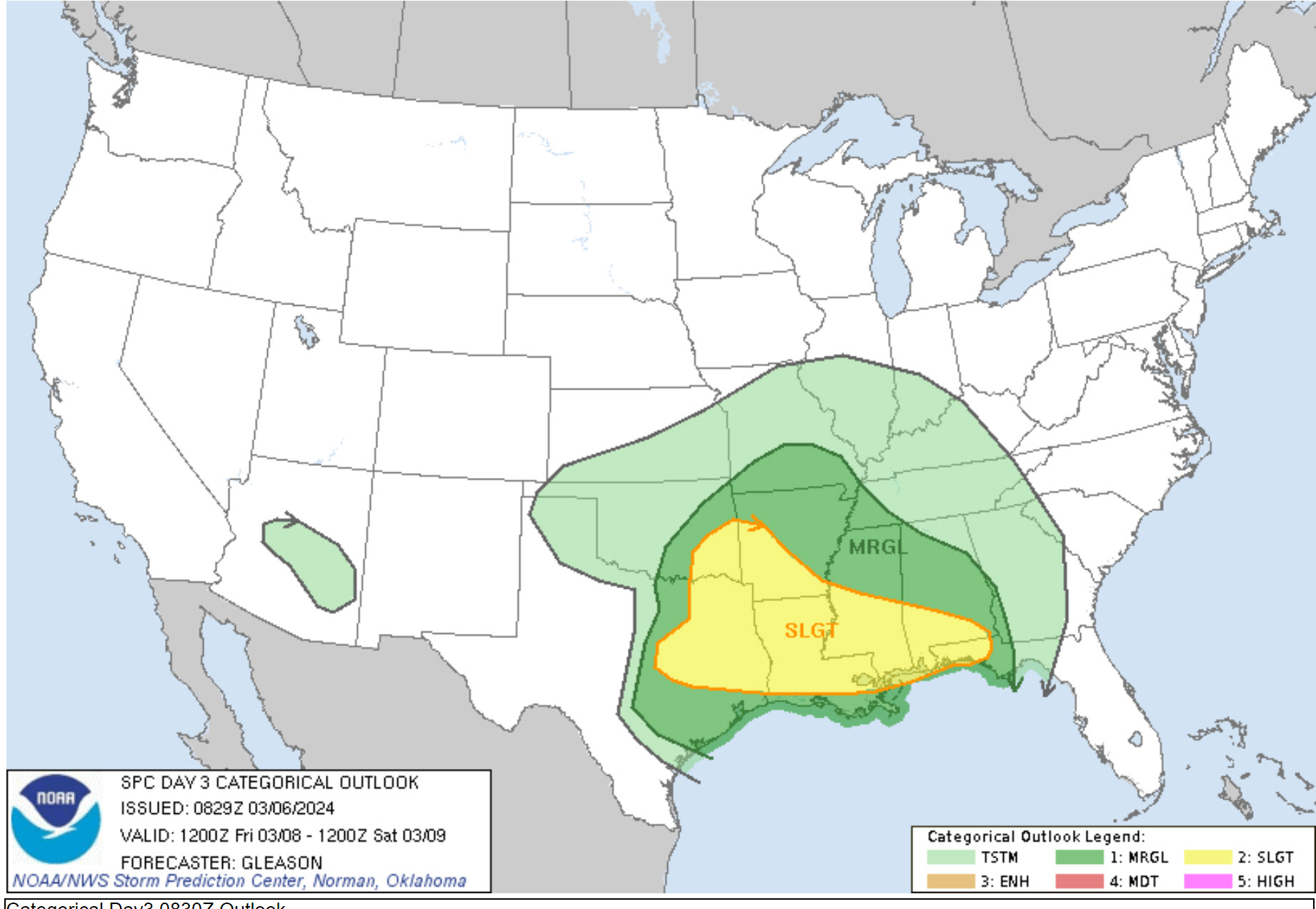
Day Three Severe Weather Outlook

.

.
The images below are from NOAA’s Weather Prediction Center.
24-hour precipitation outlook..
 .
.
.
48-hour precipitation outlook.
. .
.
![]()
_______________________________________
.

Click here if you would like to return to the top of the page.
Again, as a reminder, these are models. They are never 100% accurate. Take the general idea from them.
What should I take from these?
- The general idea and not specifics. Models usually do well with the generalities.
- The time-stamp is located in the upper left corner.
.
What am I looking at?
You are looking at computer model data. Meteorologists use many different models to forecast the weather.
Occasionally, these maps are in Zulu time. 12z=7 AM. 18z=1 PM. 00z=7 PM. 06z=1 AM
Green represents light rain. Dark green represents moderate rain. Yellow and orange represent heavier rain.
.
This animation is the HRRR Model.
Occasionally, these maps are in Zulu time. 12z=6 AM. 18z=12 PM. 00z=6 PM. 06z=12 AM
Double click images to enlarge them. Blue is snow. Pink is a wintry mix. Green is rain.
.
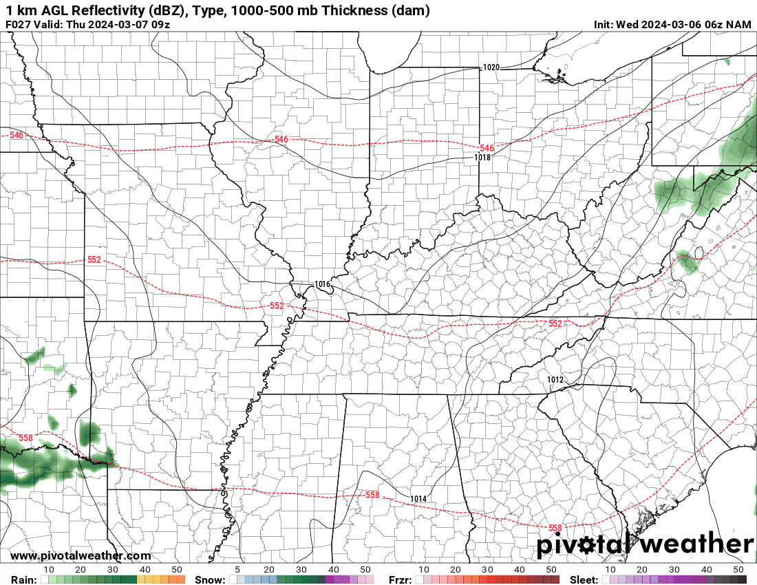
This animation is the NAM 3Z Model.
Occasionally, these maps are in Zulu time. 12z=6 AM. 18z=12 PM. 00z=6 PM. 06z=12 AM
Double click images to enlarge them.
.
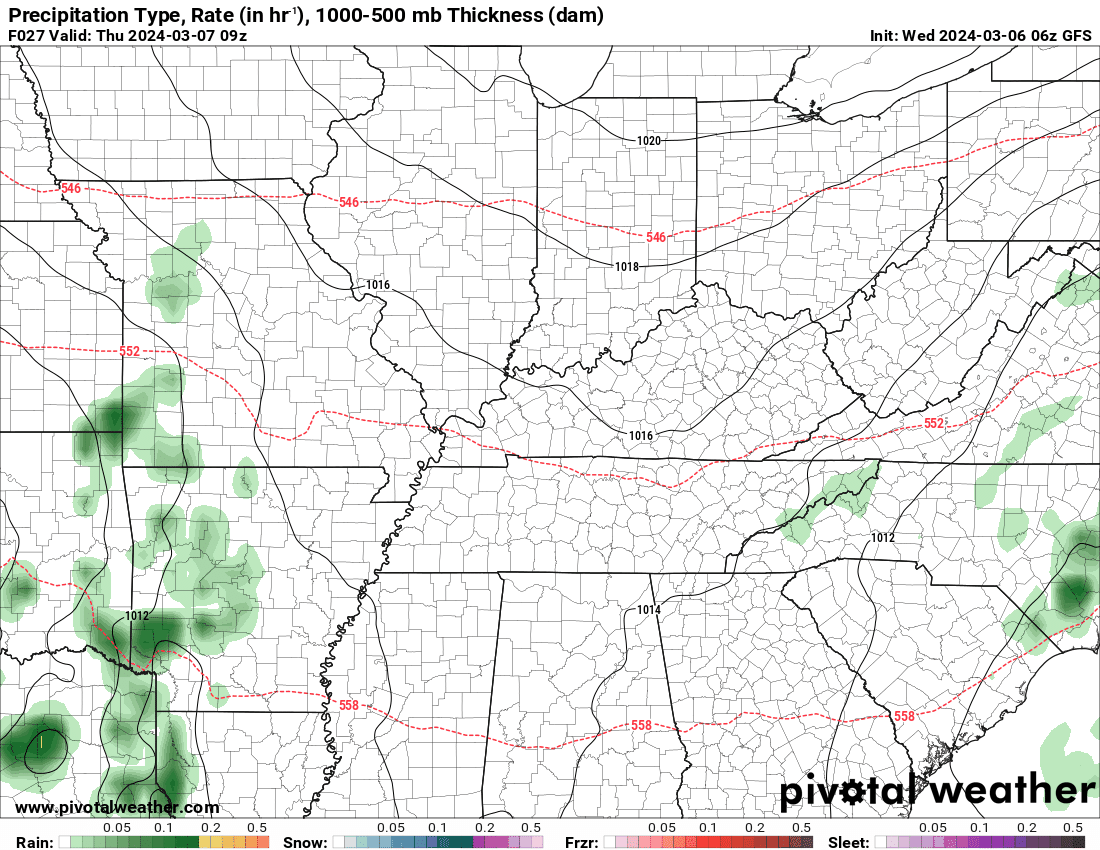
This animation is the GFS Model.
Green is rain. Yellow and orange are heavier rain. Pink is a wintry mix. Blue is snow. Dark blue is heavier snow.
Occasionally, these maps are in Zulu time. 12z=6 AM. 18z=12 PM. 00z=6 PM. 06z=12 AM
Double click images to enlarge them.
.
This animation is the EC Model.
Green is rain. Yellow and orange are heavier rain. Pink is a wintry mix. Blue is snow. Dark blue is heavier snow.
Occasionally, these maps are in Zulu time. 12z=6 AM. 18z=12 PM. 00z=6 PM. 06z=12 AM
Double click images to enlarge them.
..![]()

.
Click here if you would like to return to the top of the page.
.Average high temperatures for this time of the year are around 56 degrees.
Average low temperatures for this time of the year are around 36 degrees.
Average precipitation during this time period ranges from 0.60″ to 1.20″
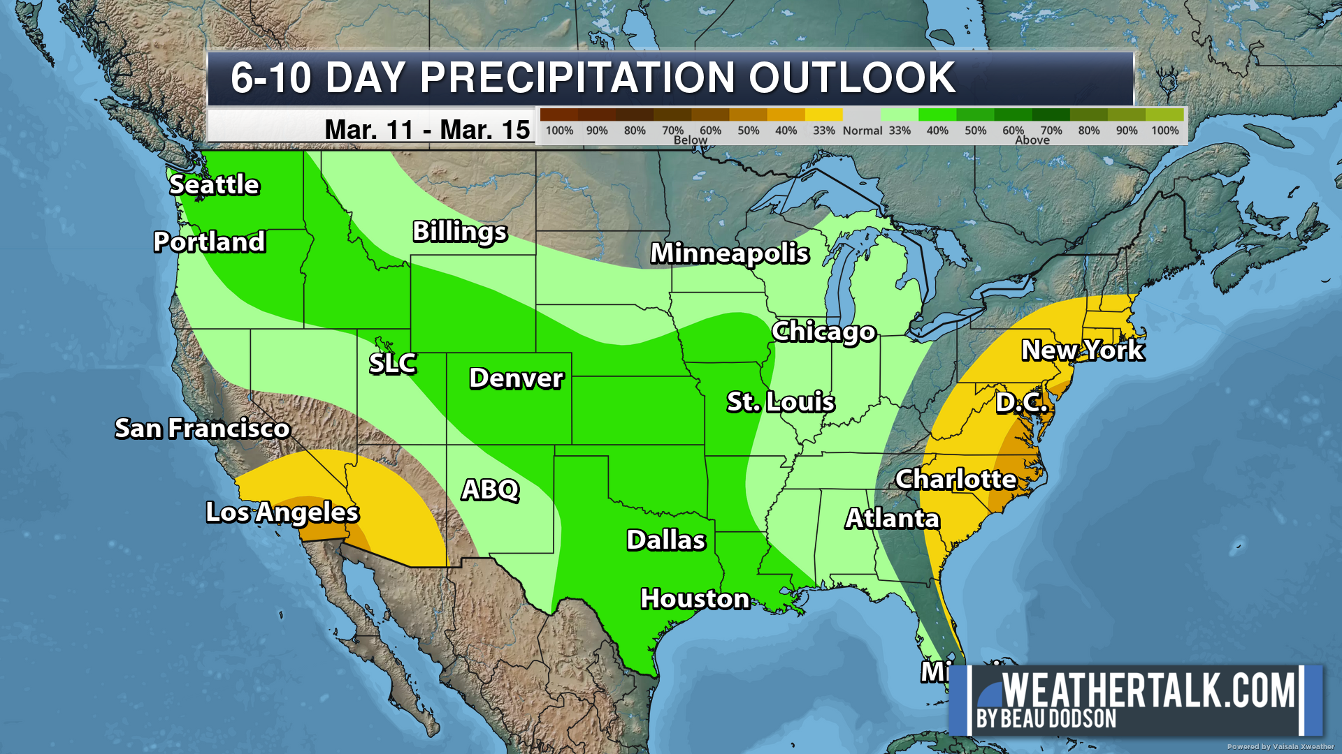
Six to Ten Day Outlook.
Blue is below average. Red is above average. The no color zone represents equal chances.
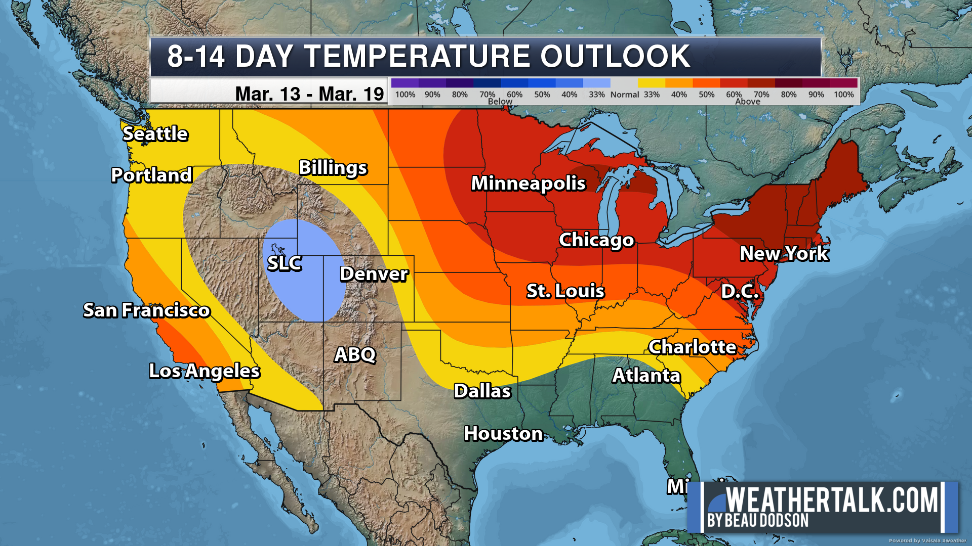
Average highs for this time of the year are in the lower 60s. Average lows for this time of the year are in the lower 40s.
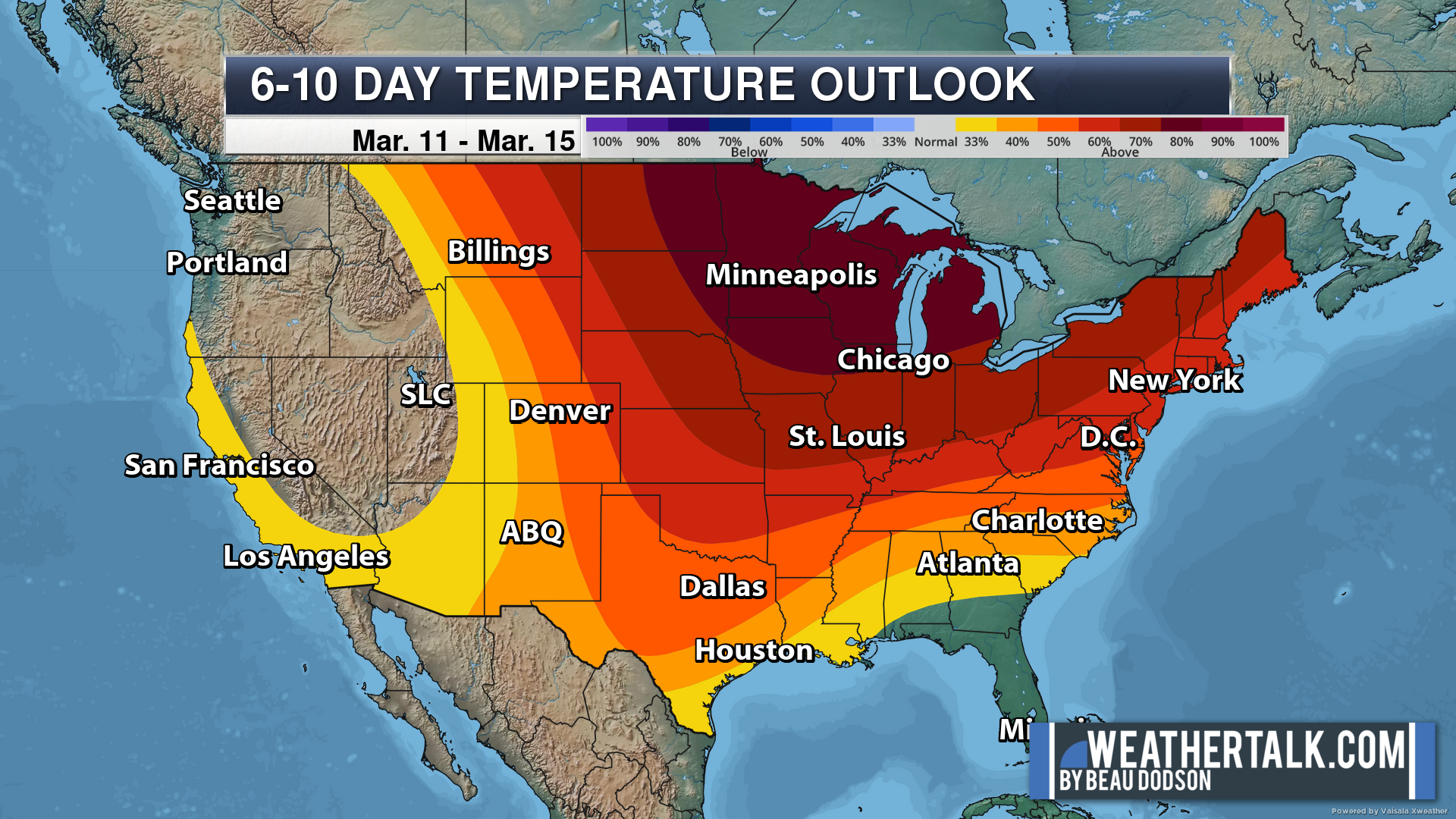
Green is above average precipitation. Yellow and brown favors below average precipitation. Average precipitation for this time of the year is around one inch per week.
.

Average low temperatures for this time of the year are around 38 degrees.
Average precipitation during this time period ranges from 0.60″ to 1.20″
.
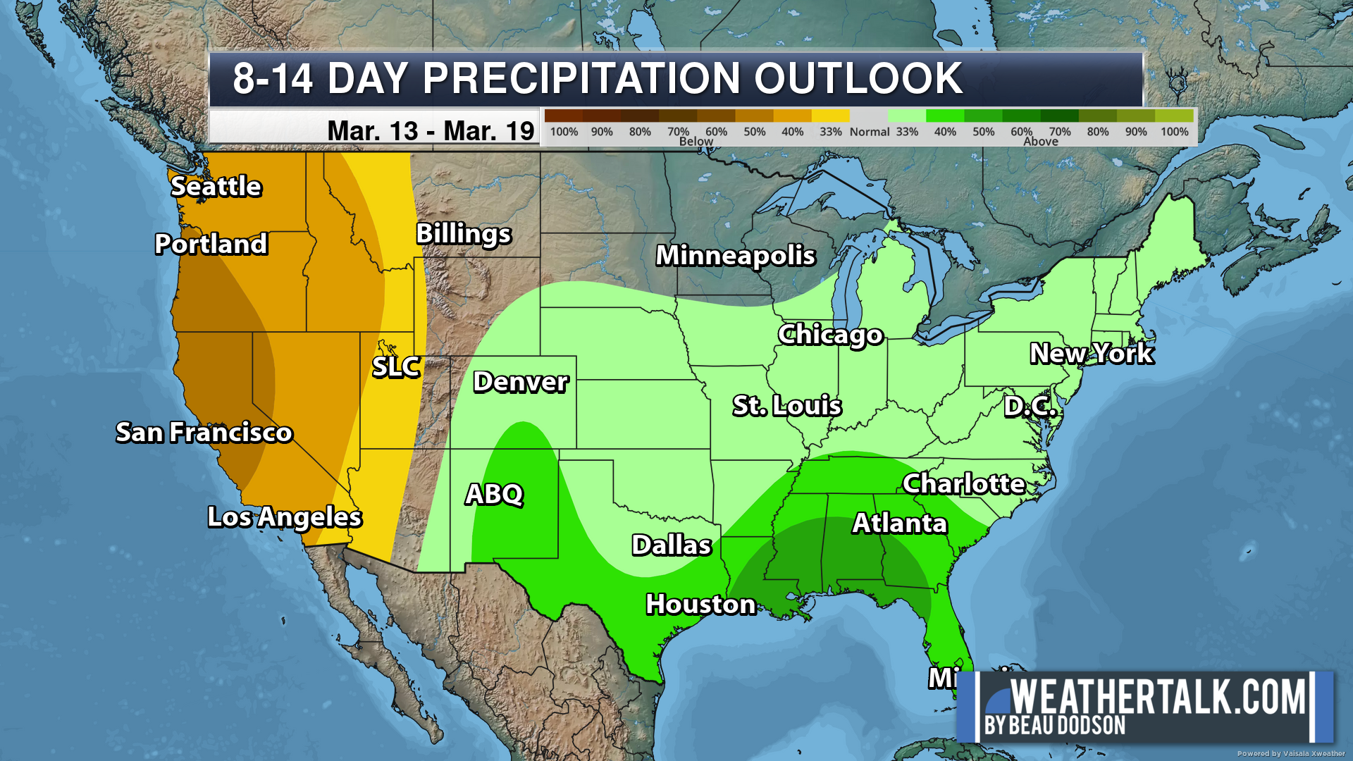
Eight to Fourteen Day Outlook.
Blue is below average. Red is above average. The no color zone represents equal chances.
Green is above average precipitation. Yellow and brown favors below average precipitation. Average precipitation for this time of the year is around one inch per week.
.
![]()
The app is for subscribers. Subscribe at www.weathertalk.com/welcome then go to your app store and search for WeatherTalk
Subscribers, PLEASE USE THE APP. ATT and Verizon are not reliable during severe weather. They are delaying text messages.
The app is under WeatherTalk in the app store.

Apple users click here

Android users click here
.

Radars and Lightning Data
Interactive-city-view radars. Clickable watches and warnings.
https://wtalk.co/B3XHASFZ
If the radar is not updating then try another one. If a radar does not appear to be refreshing then hit Ctrl F5. You may also try restarting your browser.
Backup radar site in case the above one is not working.
https://weathertalk.com/morani
Regional Radar
https://imagery.weathertalk.com/prx/RadarLoop.mp4
** NEW ** Zoom radar with chaser tracking abilities!
ZoomRadar
Lightning Data (zoom in and out of your local area)
https://wtalk.co/WJ3SN5UZ
Not working? Email me at beaudodson@usawx.com
National map of weather watches and warnings. Click here.
Storm Prediction Center. Click here.
Weather Prediction Center. Click here.
.

Live lightning data: Click here.
Real time lightning data (another one) https://map.blitzortung.org/#5.02/37.95/-86.99
Our new Zoom radar with storm chases
.
.

Interactive GOES R satellite. Track clouds. Click here.
GOES 16 slider tool. Click here.
College of DuPage satellites. Click here
.

Here are the latest local river stage forecast numbers Click Here.
Here are the latest lake stage forecast numbers for Kentucky Lake and Lake Barkley Click Here.
.
.
Find Beau on Facebook! Click the banner.


 .
.