
Are you in need of new eye glasses? New contacts? Perhaps you need an eye exam. Then be sure and visit the Eye Care Associates of western Kentucky (the Paducah location). For all of your families eye care needs.
Visit their web-site here. Or, you can also visit their Facebook page.

Best at Enabling Body Shop Profitability since 1996. Located In Paducah Kentucky and Evansville Indiana; serving all customers in between. They provide Customer Service, along with all the tools necessary for body shops to remain educated and competitive. Click the logo above for their main web-site.
You can find McClintock Preferred Finishes on Facebook, as well

Expressway Carwash and Express Lube are a locally owned and operated full-service Carwash and Lube established in 1987.
They have been proudly serving the community for 29 years now at their Park Avenue location and 20 years at their Southside location. They have been lucky enough to partner with Sidecar Deli in 2015, which allows them to provide their customers with not only quality service, but quality food as well.
If you haven’t already, be sure to make Expressway your one-stop shop, with their carwash, lube and deli. For hours of operation and pricing visit www.expresswashlube.com or Expressway Carwash on Facebook.

The quad states area source for Precision Ag Technology. Locally owned and operated, specializing in planting, harvesting, fertilizer application and drainage. Visit them on their website and on Facebook. You can also find them on Twitter. They are located in Almo, Kentucky. Phone 270-718-0245
.———————————————–
The Beau Dodson Weather APP is ready for Apple users (Android is next). The purpose of this APP is for me to deliver your text messages instantly. ATT and Verizon have not always been reliable when it comes to speed. The APP allows instant delivery. You can keep your test messages on and use the APP. You can set the APP to turn off your text messages and just receive them through the APP.
We are working on the Android APP. Hopefully, it will be available in a week or so.
The APP is for subscribers.
The direct download, for the Apple app, can be viewed here
https://itunes.apple.com/us/app/id1190136514
If you have not signed up for the texting service then you may do so at www.beaudodsonweather.com

The Android APP is ready.
Remember, the APP’s are for www.weathertalk.com subscribers. This is to get the info into your hands within one second of me hitting send.
Here is the download link for the Android version Click Here

——————————————————–
If you have not signed up for the texts messages, then please do. Link www.beaudodsonweather.com
Your support helps with all of this

and

.

This forecast update covers far southern Illinois, far southeast Missouri, and far western Kentucky. See the coverage map on the right side of the blog
.
March 4, 2017
Saturday Night Forecast Details:
Forecast: Mostly clear early. Some increase in clouds late.
What impacts are anticipated from the weather? None.
Is severe weather expected? No
The NWS defines severe weather as 58 mph winds or great, 1″ hail or larger, and/or tornadoes
What is the chance of precipitation? MO ~ 0% IL ~ 0% KY ~ 0% TN ~ 0%
Coverage of precipitation: None.
Should I cancel my outdoor plans? No
My confidence in the forecast verifying: High. This forecast should verify.
Temperatures: MO ~ 38 to 44 IL ~38 t0 44 KY ~ 38 to 44 TN ~ 40 to 45
Winds: South at 5 to 10 mph with higher gusts possible
Wind Chill when applicable:
Will there be a chance for wintry precipitation? No
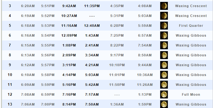
Moonrise will be at 10:27 a.m. and moonset will be at -:– Waxing Crescent
.
March 5, 2017
Sunday Forecast Details
Forecast: Windy. Partly sunny in the morning. Increasing clouds through the day. A 20% for a passing shower.
What impacts are anticipated from the weather? Perhaps wet roadways..
Is severe weather expected? No
The NWS defines severe weather as 58 mph winds or great, 1″ hail or larger, and/or tornadoes
What is the chance of precipitation? MO ~ 20% IL ~ 20% KY ~ 20% TN ~ 20%
Coverage of precipitation: None to isolated
Should I cancel my outdoor plans? No
My confidence in the forecast verifying: High. This forecast should verify.
Temperatures: MO ~ 58 to 64 IL ~ 58 to 64 KY ~ 58 to 64 TN ~ 60 to 65
Winds: South and southwest winds at 10 to 20 mph with gusts to 35 mph.
Wind Chill when applicable:
Will there be a chance for wintry precipitation? No
Sunrise will be at 6:18 a.m. and sunset will be at 5:53 p.m.
UV Index: 4 to 5
Moonrise will be at 11:16 a.m. and moonset will be at 12:40 a.m. First Quarter
Sunday Night Forecast Details:
Forecast: Cloudy. Some showers possible, especially late. Breezy.
What impacts are anticipated from the weather? Wet roadways.
Is severe weather expected? No
The NWS defines severe weather as 58 mph winds or great, 1″ hail or larger, and/or tornadoes
What is the chance of precipitation? MO ~ 40% IL ~ 30% KY ~ 30% TN ~ 30%
Coverage of precipitation: Scattered.
Should I cancel my outdoor plans? No.
My confidence in the forecast verifying: Medium. Some adjustments are possible.
Temperatures: MO ~ 46 to 52 IL ~ 46 to 52 KY ~ 48 to 54 TN ~ 48 to 54
Winds: South and southeast at 12 to 24 mph and gusts to 30 mph
Wind Chill when applicable:
Will there be a chance for wintry precipitation? No
Moonrise will be at 11:16 a.m. and moonset will be at 12:40 a.m. First Quarter
.
March 6, 2017
Monday Forecast Details
Forecast: Windy. Cloudy with showers likely. Maybe a thunderstorm.
What impacts are anticipated from the weather? Wet roadways
Is severe weather expected? Monitor updated forecasts
The NWS defines severe weather as 58 mph winds or great, 1″ hail or larger, and/or tornadoes
What is the chance of precipitation? MO ~ 70% IL ~ 70% KY ~ 60% TN ~ 60%
Coverage of precipitation: Perhaps numerous.
Should I cancel my outdoor plans? Have an alternative plan
My confidence in the forecast verifying: Medium. Some adjustments are possible.
Temperatures: MO ~ 62 to 68 IL ~ 62 to 66 KY ~ 62 to 66 TN ~ 62 to 66
Winds: South winds at 15 to 30 mph with gusts to 35+ mph.
Wind Chill when applicable:
Will there be a chance for wintry precipitation? No
Sunrise will be at 6:16 a.m. and sunset will be at 5:54 p.m.
UV Index: 0 to 2
Moonrise will be at 12:09 p.m. and moonset will be at 1:43 a.m. Waxing Gibbous
Monday Night Forecast Details:
Forecast: Cloudy. Showers. Some thunderstorms possible. A few heavy downpours possible. Windy.
What impacts are anticipated from the weather? Wet roadways. Lightning.
Is severe weather expected? Monitor updates.
The NWS defines severe weather as 58 mph winds or great, 1″ hail or larger, and/or tornadoes
What is the chance of precipitation? MO ~ 80% IL ~ 80% KY ~ 80% TN ~ 80%
Coverage of precipitation: Numerous
Delete repeated word I cancel my outdoor plans? No
My confidence in the forecast verifying: High. This forecast should verify.
Temperatures: MO ~ 55 to 60 IL ~ 55 to 60 KY ~ 55 to 60 TN ~ 55 to 60
Winds: South and southwest at 10 to 20 mph with gusts to 30 and above
Wind Chill when applicable:
Will there be a chance for wintry precipitation? No
Moonrise will be at 12:09 p.m. and moonset will be at 1:43 a.m. Waxing Gibbous
.
March 7, 2017
Tuesday Forecast Details
Forecast: Cloudy. A chance for showers. Thunderstorms possible. A few heavy downpours possible as the cold front moves through the region during the late morning and afternoon hours.
What impacts are anticipated from the weather? Wet roadways and lightning. Gusty winds with any storms that form.
Is severe weather expected? Monitor updates.
The NWS defines severe weather as 58 mph winds or great, 1″ hail or larger, and/or tornadoes
What is the chance of precipitation? MO ~ 70% IL ~ 70% KY ~ 70% TN ~ 70%
Coverage of precipitation: Numerous
Should I cancel my outdoor plans? Have an alternative plan
My confidence in the forecast verifying: Medium. Some adjustments are possible.
Temperatures: MO ~ 64 to 68 IL ~ 64 to 68 KY ~ 64 to 68 TN ~ 64 to 68
Winds: West and southwest winds at 6 to 12 mph with gusty winds.
Wind Chill when applicable:
Will there be a chance for wintry precipitation? No
Sunrise will be at 6:15 a.m. and sunset will be at 5:55 p.m.
UV Index: 0 to 2
Moonrise will be at 1:08 p.m. and moonset will be at 2:41 a.m. Waxing Gibbous
Tuesday Night Forecast Details:
Forecast: Showers ending. Becoming partly cloudy. Cooler.
What impacts are anticipated from the weather? Perhaps evening wet roadways and lightning. Most likely the rain will have ended by Tuesday evening and night.
Is severe weather expected? No
The NWS defines severe weather as 58 mph winds or great, 1″ hail or larger, and/or tornadoes
What is the chance of precipitation? MO ~ 0% IL ~ 0% KY ~ 10% TN ~ 10%
Coverage of precipitation: Ending
Should I cancel my outdoor plans? No.
My confidence in the forecast verifying: High. This forecast should verify.
Temperatures: MO ~ 35 to 40 IL ~ 34 to 38 KY ~ 35 to 40 TN ~ 38 to 44
Winds: West and northwest at 6 to 12 mph
Wind Chill when applicable:
Will there be a chance for wintry precipitation? No
Moonrise will be at 1:08 p.m. and moonset will be at 2:41 a.m. Waxing Gibbous
.
March 8, 2017
Wednesday Forecast Details
Forecast: Mostly sunny. Mild.
What impacts are anticipated from the weather? None.
Is severe weather expected? No.
The NWS defines severe weather as 58 mph winds or great, 1″ hail or larger, and/or tornadoes
What is the chance of precipitation? MO ~ 0% IL ~ 0% KY ~ 0% TN ~ 0%
Coverage of precipitation: None
Should I cancel my outdoor plans? Have an alternative plan
My confidence in the forecast verifying: Medium. Some adjustments are possible.
Temperatures: MO ~ 58 to 64 IL ~ 58 to 64 KY ~ 58 to 64 TN ~ 60 to 65
Winds: West at 5 to 10 mph
Wind Chill when applicable:
Will there be a chance for wintry precipitation? No
Sunrise will be at 6:13 a.m. and sunset will be at 5:56 p.m.
UV Index: 5 to 7
Moonrise will be at 2:09 p.m. and moonset will be at 3:34 a.m. Waxing Gibbous
Wednesday Night Forecast Details:
Forecast: Clear. Cool.
What impacts are anticipated from the weather? None.
Is severe weather expected? No
The NWS defines severe weather as 58 mph winds or great, 1″ hail or larger, and/or tornadoes
What is the chance of precipitation? MO ~ 0% IL ~ 0% KY ~ 0% TN ~ 0%
Coverage of precipitation: None
Should I cancel my outdoor plans? No.
My confidence in the forecast verifying: Medium. Some adjustments are possible.
Temperatures: MO ~ 35 to 40 IL ~ 35 to 40 KY ~ 35 to 40 TN ~ 35 to 40
Winds: West and southwest at 5 mph
Wind Chill when applicable:
Will there be a chance for wintry precipitation? No
Moonrise will be at 2:09 p.m. and moonset will be at 3:34 a.m. Waxing Gibbous
More information on the UV index. Click here
The School Bus Stop Forecast is sponsored by Heath Health and Wellness.
Located next to Crowell Pools in Lone Oak, Kentucky.
Visit their website here. Visit Heath Health Foods on Facebook!

Heath Health Foods is a locally owned and operated retail health and wellness store. Since opening in February 2006; the store has continued to grow as a ministry with an expanding inventory which also offers wellness appointments and services along with educational opportunities.
Visit their web-site here. And. visit Heath Health Foods on Facebook!.


Don’t forget to check out the Southern Illinois Weather Observatory web-site for weather maps, tower cams, scanner feeds, radars, and much more! Click here

An explanation of what is happening in the atmosphere over the coming day
Analysis
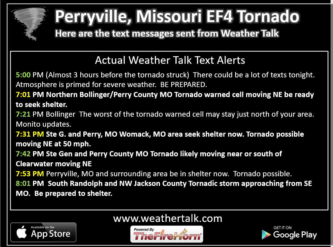
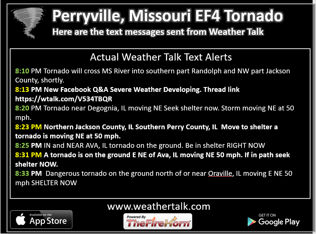
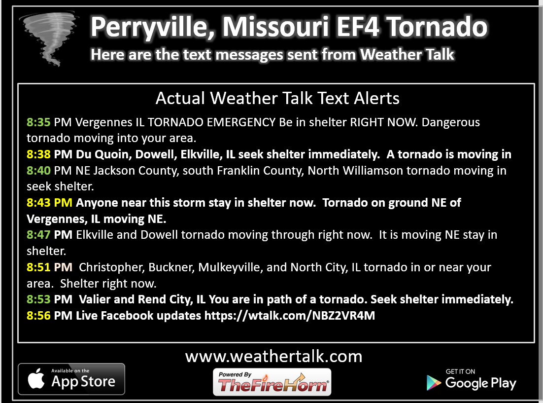
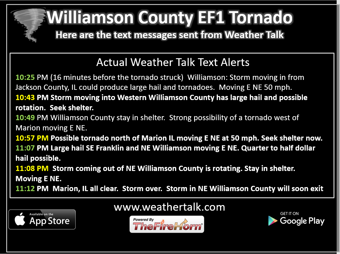
For those who subscriber to the WeatherTalk.com text messages, here are some of the texts that I sent out during the tornado outbreak
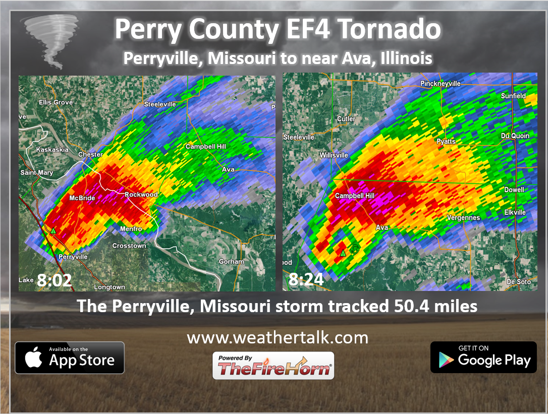
Here is the sequence of text messages sent out during the EF4 Perryville, Missouri tornado.
These are the strongest text messages that I have sent out, since starting the Weather Talk texting services.
This is the strongest tornado, as well.
I will post a series of graphics showing the tornado and the texts.
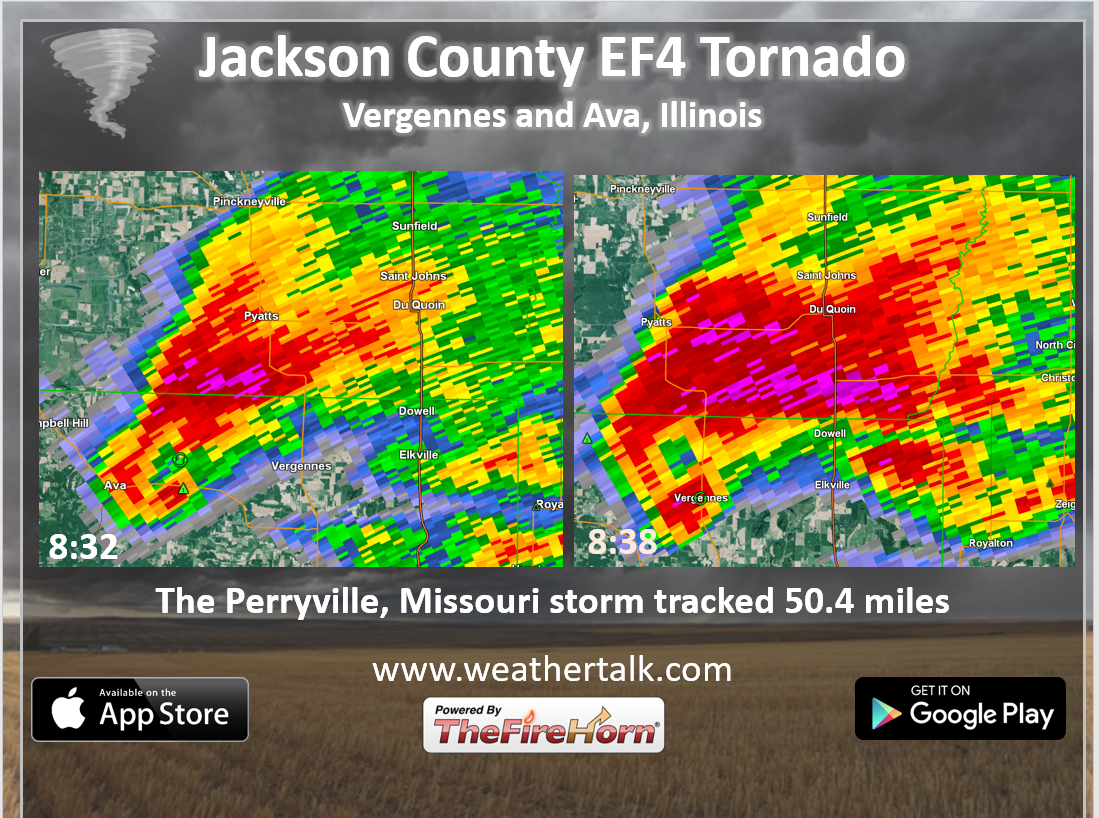
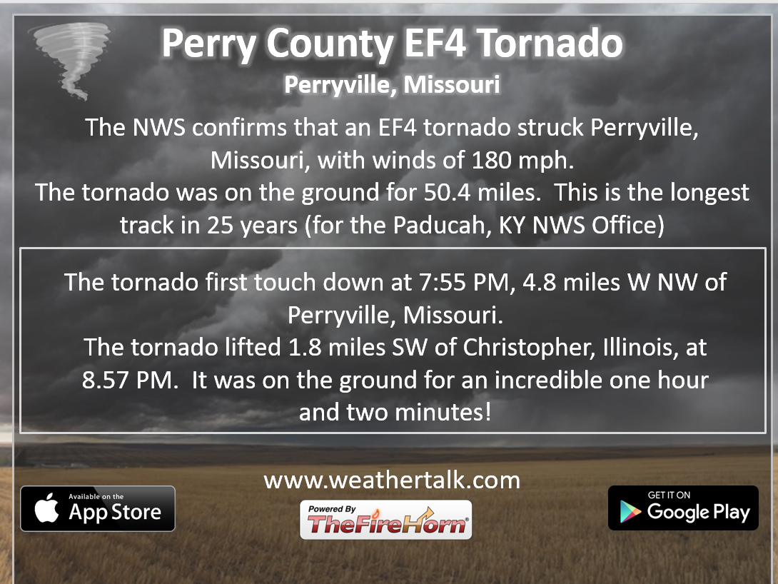
The NWS has determined that an EF4 tornado struck Perryville, Missouri. The tornado then crossed the Mississippi River into extreme southern Randolph County and northern Jackson County.
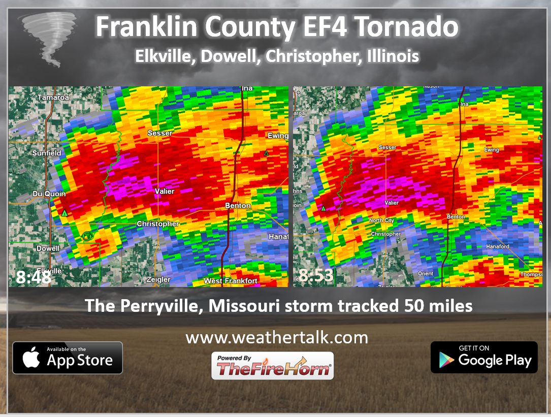
The tornado then tracked into Franklin County, Illinois.
The tornado was on the ground an incredible one hour and two minutes.
The tornado quickly became violent reaching EF-4 intensity and leveling 5 homes, as well as other structures, just west of I-55, about 3.5 miles northwest of Perryville, Missouri.
This is in the Kyle Lane and County Road 806 area. Numerous uninhabited cars from a salvage yard were blown into or over I-55.
The lone fatality occurred when an I-55 southbound vehicle was intercepted by the tornado.
As the tornado tore east, it caused the area of greatest home and property destruction 3 miles north of Perryville, in the vicinity of U.S. Highway 61 and Moore Drive.
Three homes were leveled on the west side of U.S. Highway 61 with dozens of other homes and structures destroyed.
Several of the injuries occurred in this area.
In addition to the leveled homes in Perry County, at least 100 other homes received moderate to major damage.
As the tornado continued east across Perry County, it leveled or nearly leveled 2 additional homes and destroyed numerous other homes and structures.
The tornado reached its greatest width as it approached the Mississippi River where a damage swath 0.6 miles wide was measured.
The tornado damage path also exhibited multiple vortex characteristics at this point, yielding three distinct convergent areas within the parent vortex.
This was also indicated via ground striations, or disturbance marks to bare ground, just west of the Mississippi River.
The tornado then ripped across the southern tip of Randolph County Illinois just south of Rockwood.
It then continued its ENE path across Jackson County Illinois passing just south of Ava, Illinois and immediately south of Vergennes, Illinois.
Many thousands of large trees were snapped and uprooted, and dozens of homes and other structures were damaged or destroyed across Jackson and Franklin Counties.
The tornado remained very intense and wide (at least 1/3 mile) nearly leveling a home as it passed between Elkville and Dowell, Illinois and into Franklin County with unabating intensity.
A house was leveled 1.75 miles south of Mulkeytown.
Very soon thereafter the tornado began to rapidly weaken, before dissipating 1.8 miles southwest of Christopher.
The tornado lasted an astounding 1 hour and 2 minutes and was the longest track tornado in the coverage area of NWS Paducah since another EF-4 tornado back on April 22, 1981.
All of this information is from the Paducah, Kentucky, National Weather Service.
————————————————————-
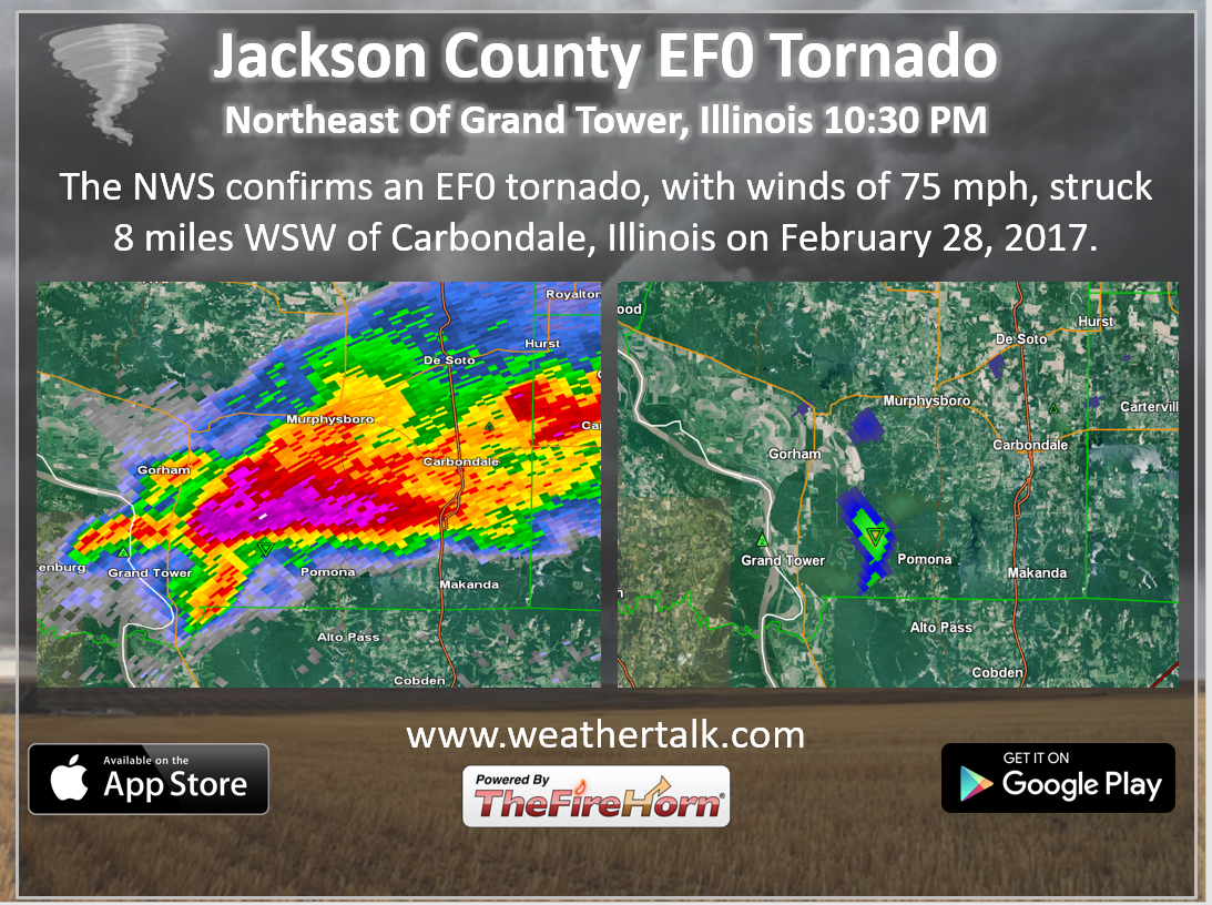
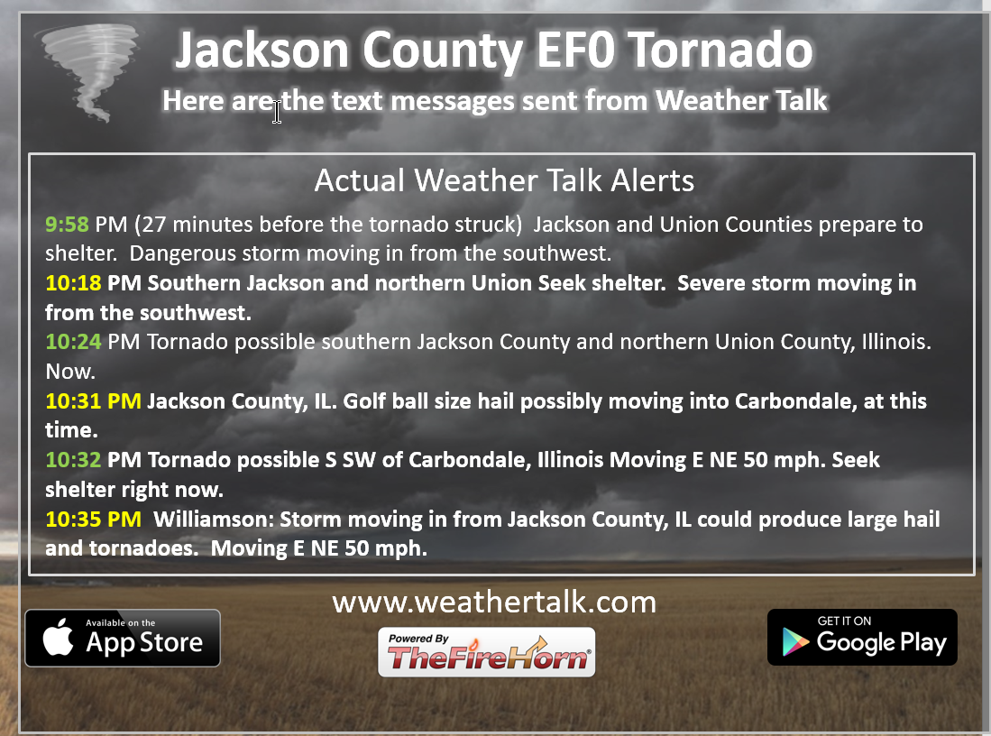
Jackson County, IL EF0 tornado
Click images to enlarge
————————————————
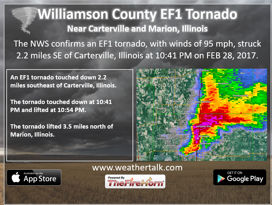
This is the Williamson County EF1 tornado
————————————————-
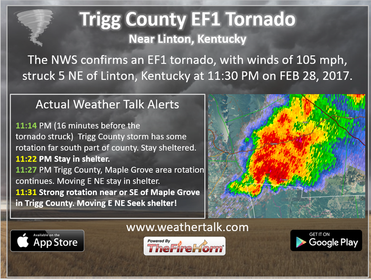
Trigg County, Kentucky EF1 tornado
—————————————————-
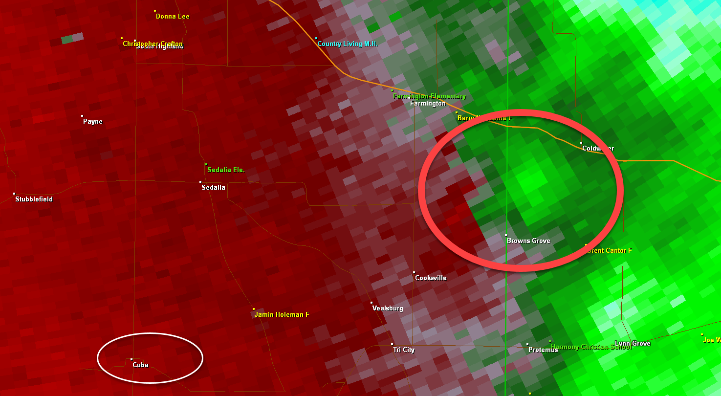
uba, Kentucky EF2 tornado. Graves County.
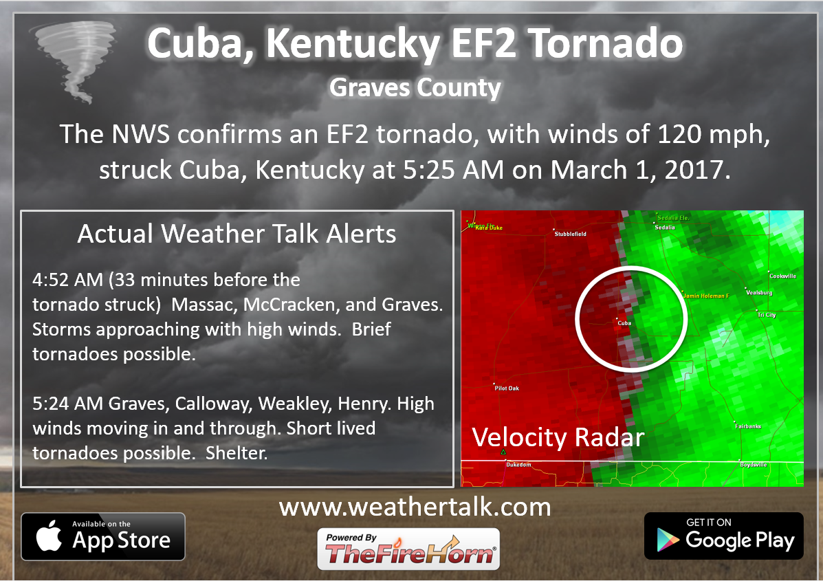
The green beside the red is the location of the tornado. Difficult to find on radar.
Here is the same storm a few miles further northeast. Perhaps the tornado touched down again, unsure. NWS will look into this
This is the Browns Grove area of Graves County, KY.
.
Saturday night
Confidence: High
Calm weather tonight. Winds may start to increase a bit overnight. Temperatures won’t be as cold as Friday night. You can expect upper 30’s to lower 40’s by Sunday morning. A few spots might be cooler if we remain cloud free most of the night.
Sunday and Sunday night
Confidence: Medium
Clouds will begin to increase as we move through the day on Sunday. Breezy conditions will develop with gusts above 20 mph. The gusty southerly winds will help bump temperatures up a bit. It will also mean a return of moisture.
Some of the models are popping some showers in the region on Sunday. I will continue to mention the possibility.
If we can squeak out quite a bit of sun on Sunday, then temperatures should easily pop into the 60’s. Models are advertising 50’s, but I believe they are likely too low.
Most of the rain should hold off until late Sunday night and Monday. I included a 20% chance. Increasing chances on Sunday night (especially late).
Monday into Tuesday
Confidence: Medium
Windy conditions develop on Monday. Winds could gust to 30 ~ 40 mph.
Showers and thunderstorm chances increase on Monday into Tuesday. This will occur as a cold front enters the picture. The front won’t clear our region until Tuesday late morning into the afternoon hours.
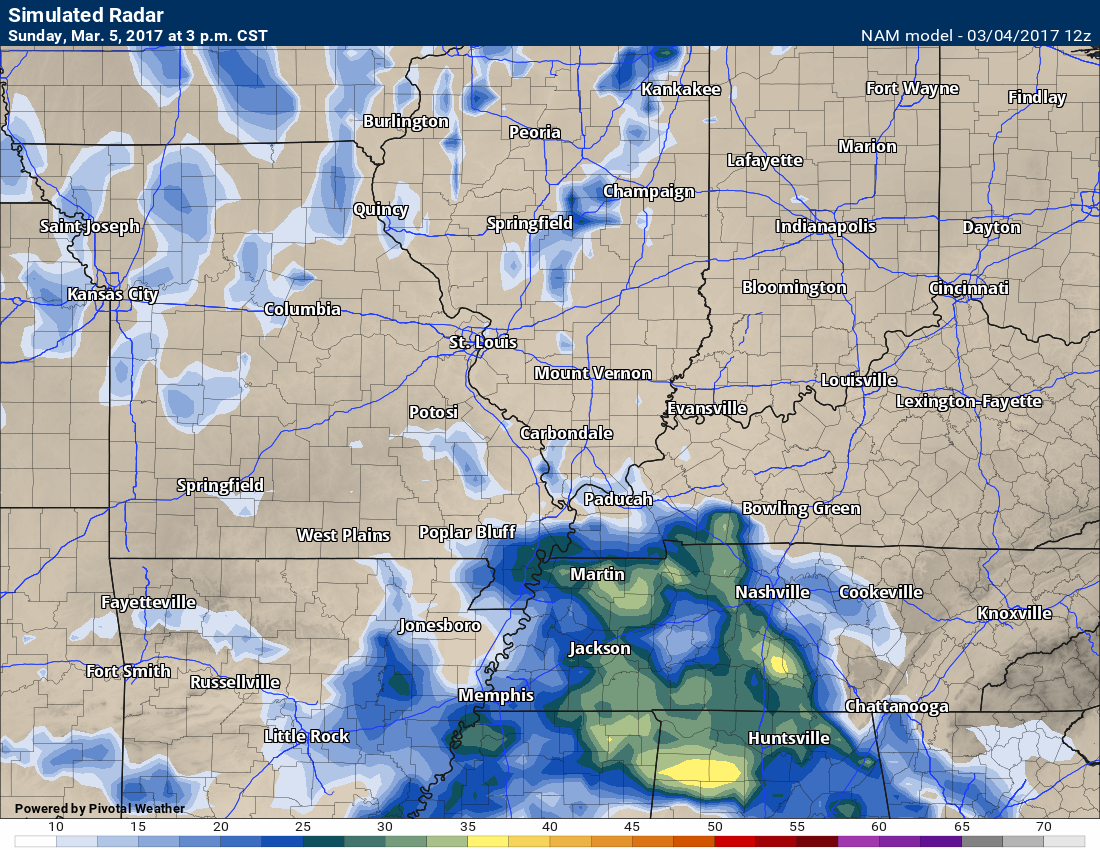
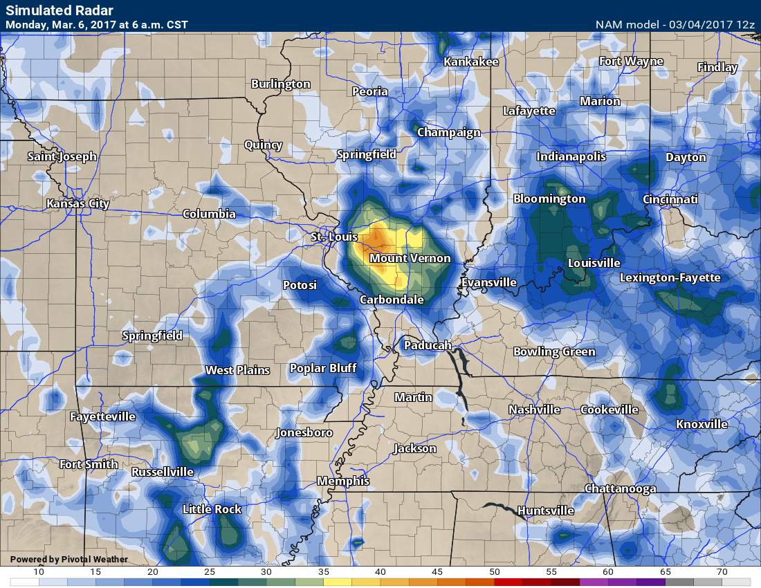
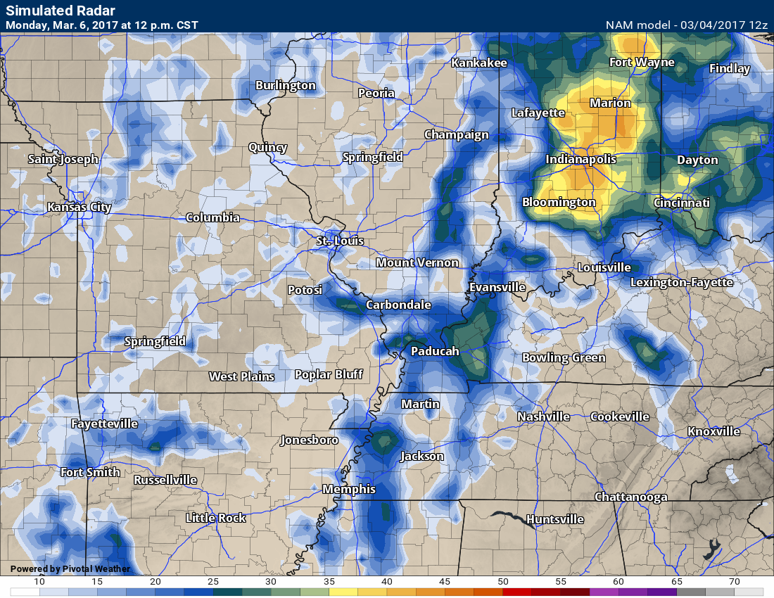
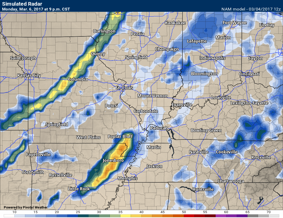
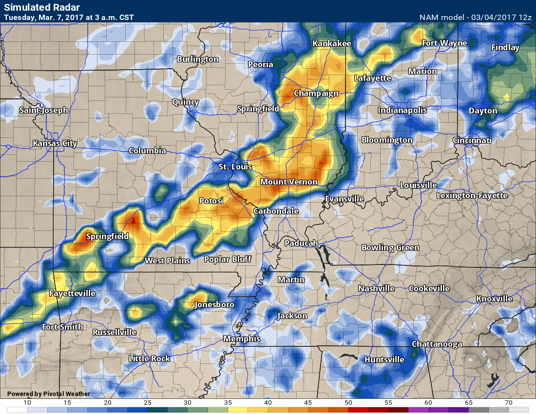
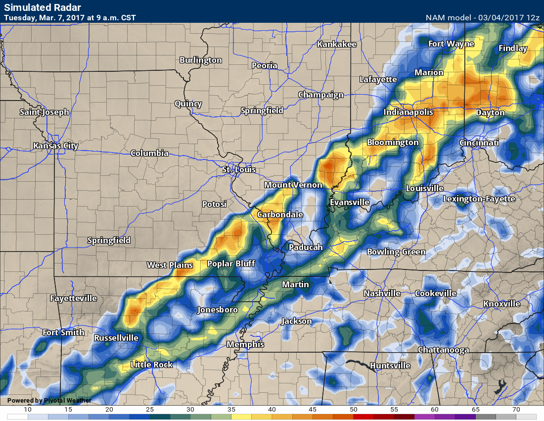
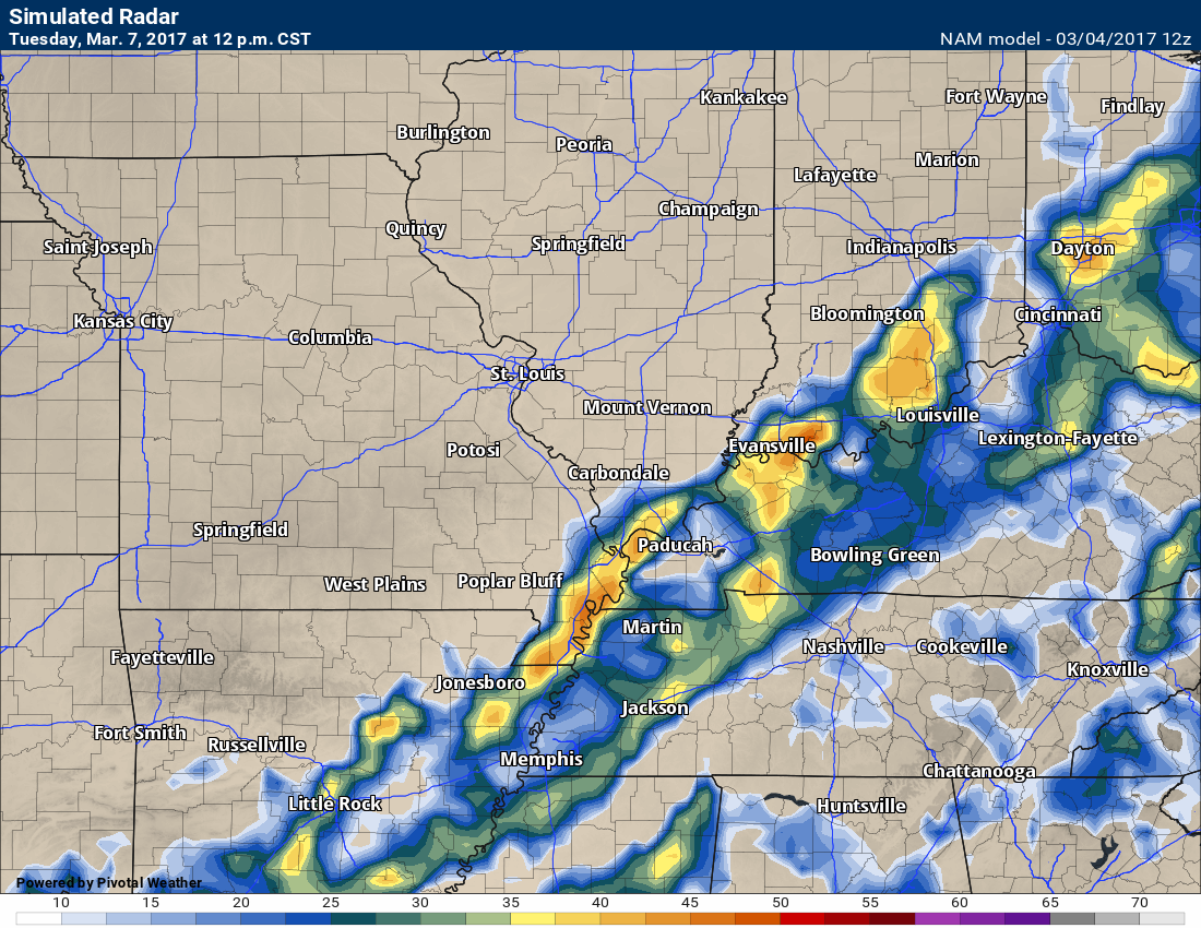
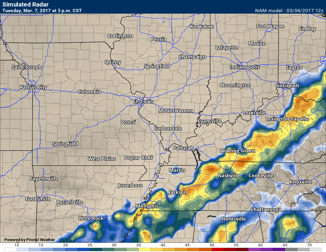
Let’s look at the NAM model and future-cast radar
Remember, this is just one models opinion on precipitation placement. It won’t be exact. Just take the general idea from the images.
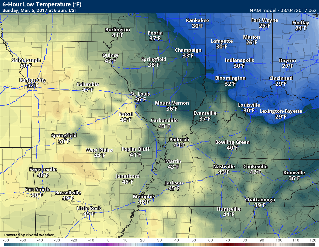
This first image is for Sunday. The NAM wants to pop some showers in the region. This will need to be monitored.
This next image is for 6 am on Monday
This next image is for 12 pm on Monday
This next image is for 9 pm Monday
This next image is for 3 am on Tuesday
This next image is for 9 am on Tuesday
This next image is for 12 pm on Tuesday
This next image is for 3 pm on Tuesday
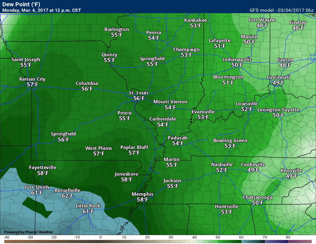
You can see the moisture pulled northward via the dew point maps for Monday into Tuesday. Dew points are a great way to measure moisture at the lower levels of the atmosphere. A better product than relative humidity.
Here is the 12 PM dew point map for Monday. You can see dew points rising into the 50’s. Remember, once we move to 58 degrees and above, I start to think about heavier thunderstorms.
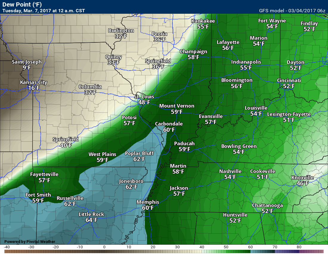
Here is the 12 AM Tuesday map. Dew points may rise to or above 58. We will need to watch for a few heavy storms on Monday night.
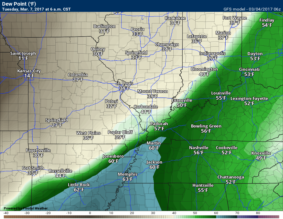
You can see dew points fall off sharply once the front moves through
Here is the 6 AM Tuesday map
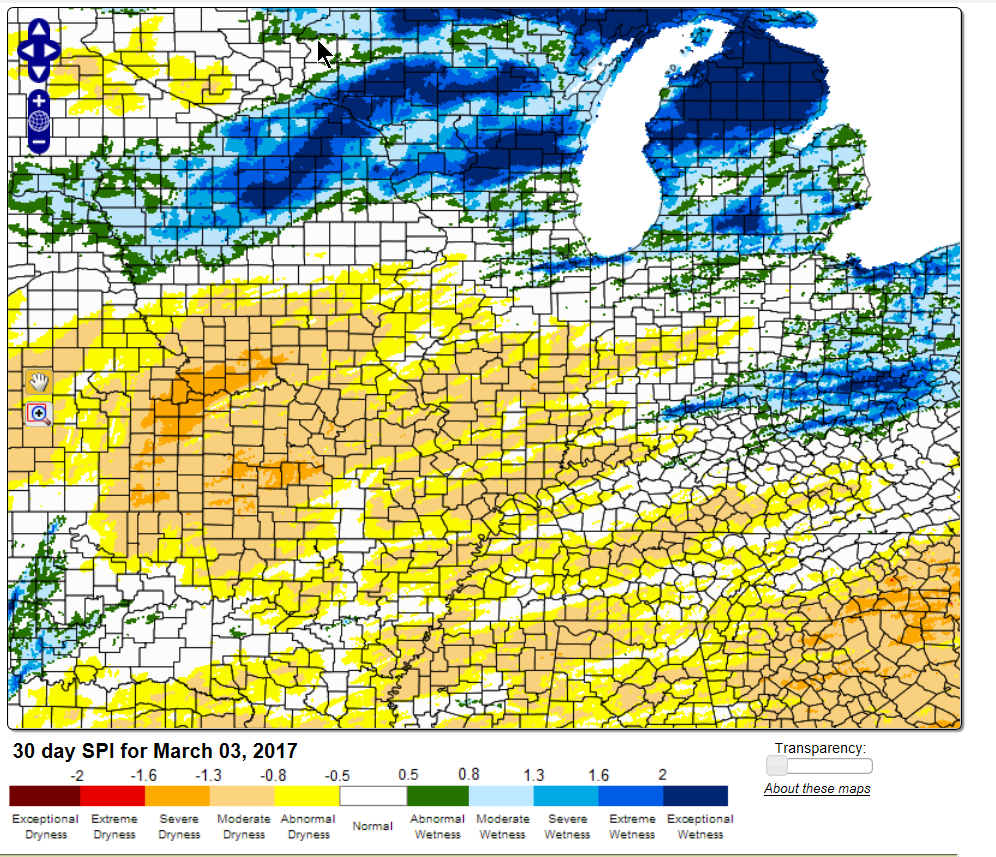
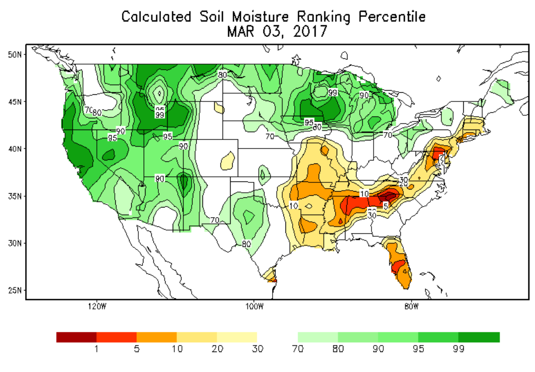
We need rain. Here are the latest drought maps
This first map is SPI. It works well for showing areas that are dry.
This next map is the drought index map
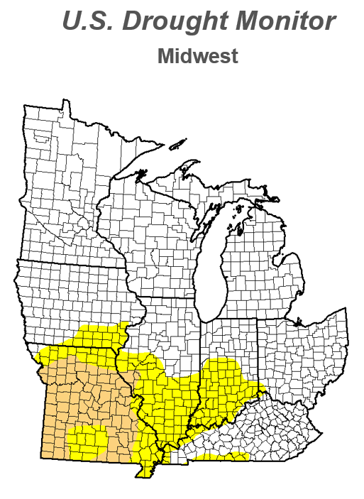
Here is the key for the above map. Drought developing. Already drought conditions in Missouri
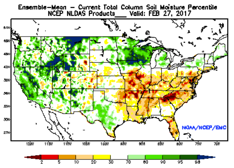
A couple of more maps showing soil moisture anomalies
and
.
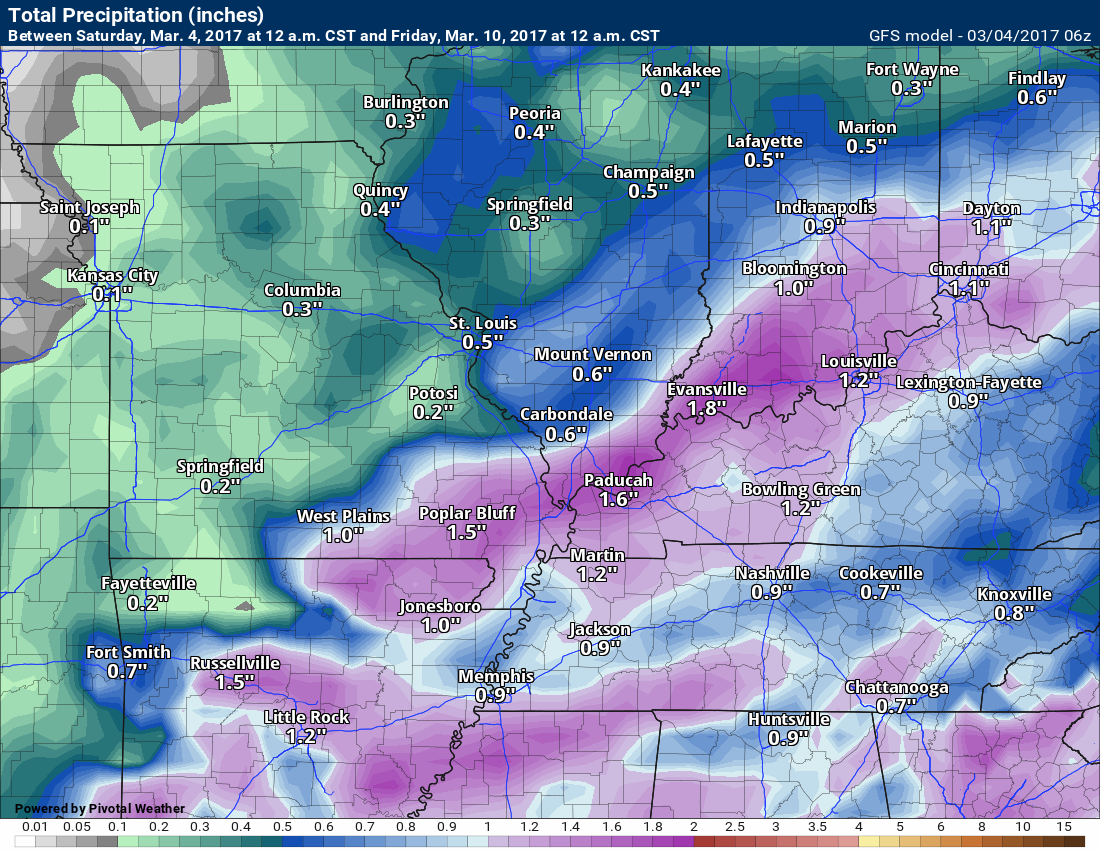
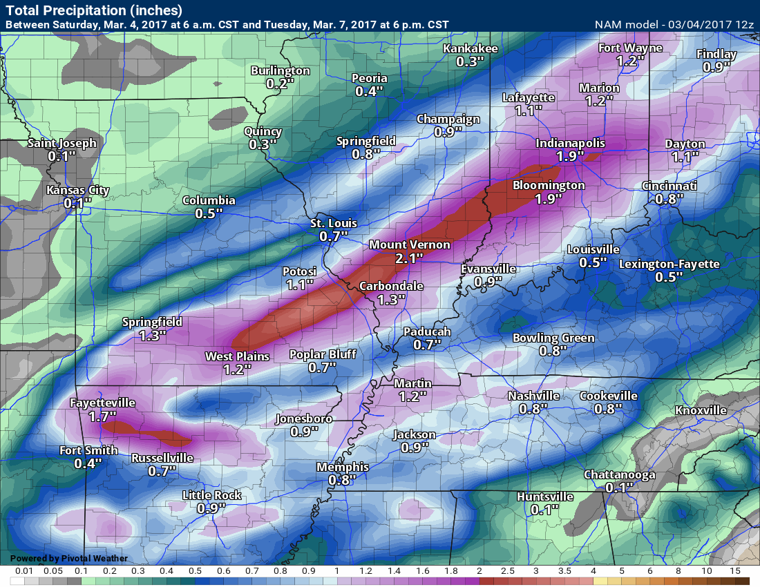
How much rain might fall with the cold front? Right now I am thinking 0.40″ to 0.80″ with pockets of 1″ or more possible (if thunderstorms develop). That would be a decent rain event.
Here is the GFS rain forecast. GFS has been overplayed a bit lately. We will see.
NAM shows some locally heavy rain, as well
This will change, but you get the idea. Some rain is likely Monday and Tuesday
.
Find me on Twitter

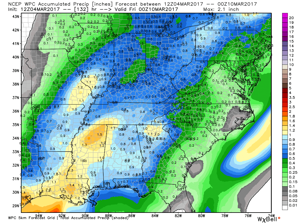
How much rain is expected over the coming days?
Here is the official NOAA rainfall prediction
Most of this falls on Monday and Tuesday
We could use this rain.
High and Low-Temperature Outlook
Sunday low temperature forecast
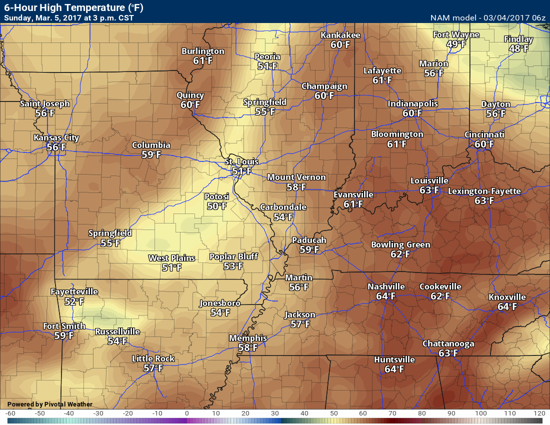
Sunday afternoon high temperature forecast
These temperatures might be too cool. This will depend on cloud cover. If we have plenty of sun on Sunday then temperatures will rise into the 60’s.
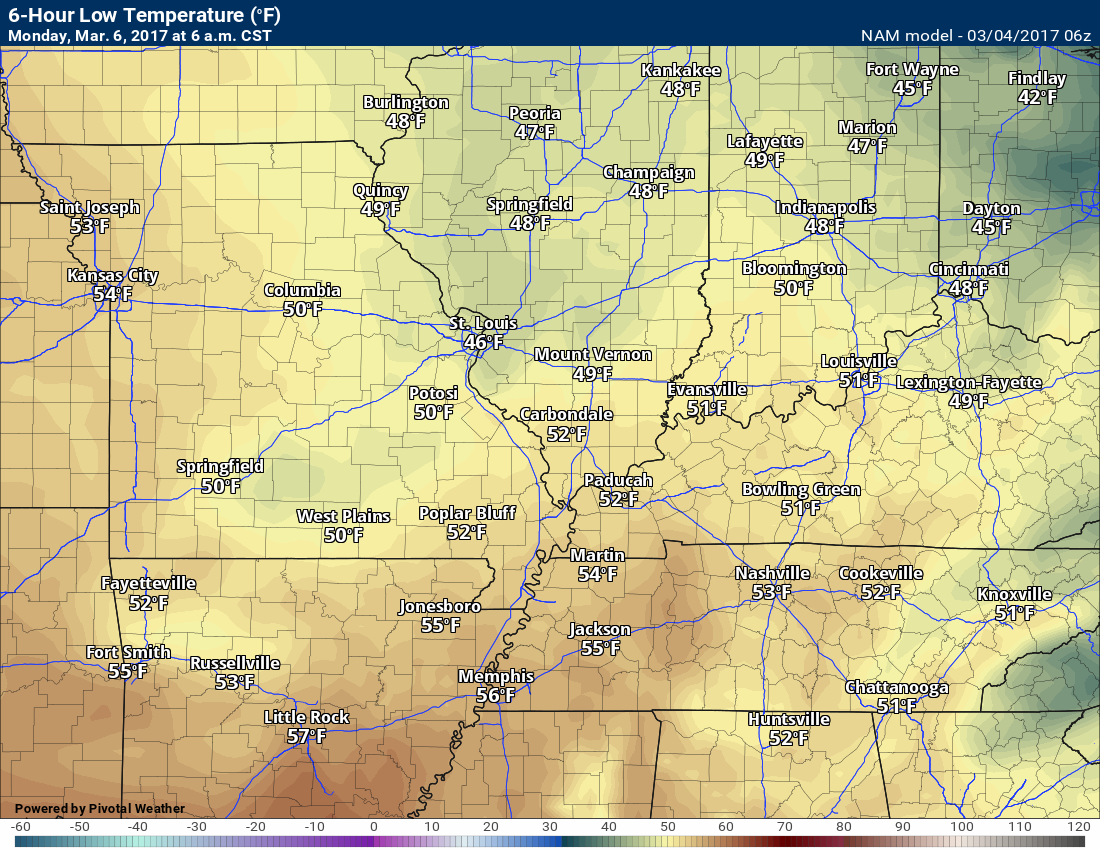
Monday low temperature forecast
Monday high temperature forecast
Temperatures, on this map, might be too cool

No major concerns.
.

Severe thunderstorm outlook.
Remember that a severe thunderstorm is defined as a thunderstorm that produces 58 mph winds or higher, quarter size hail or larger, and/or a tornado.
Saturday night through Sunday night: Severe weather is not anticipated. Perhaps a risk of lightning after 1 am Monday morning
Monday and Tuesday: A cold front will approach from the west. Thunderstorms are possible. Wind shear will be high. Instability may be lacking. Thunderstorms are possible. The risk for severe weather is not zero. Monitor updates.

We have regional radars and local city radars – if a radar does not update then try another one. Occasional browsers need their cache cleared. You may also try restarting your browser. That usually fixes the problem. Occasionally we do have a radar go down. That is why I have duplicates. Thus, if one fails then try another one.
During the winter you can track snow and ice by clicking the winterize button on the local city view interactive radars.
If you have any problems then please send me an email beaudodson@usawx.com
Interactive Weather Radar Page. Choose the city nearest your location: Click this link—
National interactive radar: Click this link.
Local interactive city radars include St Louis, Mt Vernon, Evansville, Poplar Bluff, Cape Girardeau, Marion, Paducah, Hopkinsville, Memphis, Nashville, Dyersburg, and all of eastern Kentucky. These are interactive radars. Local city radars – click here
Regional Radar


Here are the current river stage forecasts. You can click your state and then the dot for your location. It will bring up the full forecast and hydrograph.
..

The official 6-10 day and 8-14 day temperature and precipitation outlook. Check the date stamp at the top of each image (so you understand the time frame).
The forecast maps below are issued by the Weather Prediction Center (NOAA)


The latest 8-14 day temperature and precipitation outlook. Note the dates are at the top of the image. These maps DO NOT tell you how high or low temperatures or precipitation will be. They simply give you the probability as to whether temperatures or precipitation will be above or below normal.


Who do you trust for your weather information and who holds them accountable?
I have studied weather in our region since the late 1970’s. I have 39 years of experience in observing our regions weather patterns. My degree is in Broadcast Meteorology and a Bachelor’s of Science.
My resume includes:
Member of the American Meteorological Society.
NOAA Weather-Ready Nation Ambassador.
Meteorologist for McCracken County Emergency Management. I served from 2005 through 2015.
Meteorologist for McCracken County Rescue. 2015 through current
I own and operate the Southern Illinois Weather Observatory.
I am the chief meteorologist for Weather Talk LLC. I am the owner of Weather Talk LLC.
I am also a business owner in western Kentucky.
Recipient of the Mark Trail Award, WPSD Six Who Make A Difference Award, Kentucky Colonel, and the Caesar J. Fiamma” Award from the American Red Cross.
In 2005 I helped open the largest American Cross shelter in U.S. history in Houston, Texas. I was deployed to help after Hurricane Katrina and Hurricane Rita. I was a shelter manager of one of the Houston, Texas shelter divisions.
In 2009 I was presented with the Kentucky Office of Highway Safety Award.
Recognized by the Kentucky House of Representatives for my service to the State of Kentucky leading up to several winter storms and severe weather outbreaks.
If you click on the image below you can read the Kentucky House of Representatives Resolution.

I am also President of the Shadow Angel Foundation which serves portions of western Kentucky and southern Illinois.
There is a lot of noise on the internet. A lot of weather maps are posted without explanation. Over time you should learn who to trust for your weather information.
My forecast philosophy is simple and straight forward.
- Communicate in simple terms
- To be as accurate as possible within a reasonable time frame before an event
- Interact with you on Twitter, Facebook, email, texts, and this blog
- Minimize the “hype” that you might see on some television stations or through other weather sources
- Push you towards utilizing wall-to-wall LOCAL TV coverage during severe weather events
Many of the graphics on this page are from www.weatherbell.com
WeatherBell is a great resource for weather model guidance.


You can sign up for my AWARE email by clicking here I typically send out AWARE emails before severe weather, winter storms, or other active weather situations. I do not email watches or warnings. The emails are a basic “heads up” concerning incoming weather conditions