March 26, 2018
Monday Forecast Details
Forecast: Cloudy. Rain increasing southwest to northeast as the day wears on. Lightning possible.
Temperatures: MO ~ 58 to 64 IL ~ 58 to 64 KY ~ 58 to 64 TN ~ 58 to 64
What is the chance of precipitation? MO ~ 70% IL ~ 70% KY ~60% TN ~ 60%
Coverage of precipitation: Scattered to perhaps widespread
Winds: South and southeast 8 to 16 mph with gusts to 20 mph
What impacts are anticipated from the weather? Wet roadways. Lightning.
My confidence in the forecast verifying: High
Is severe weather expected? Unlikely
The NWS defines severe weather as 58 mph wind or great, 1″ hail or larger, and/or tornadoes
Should I cancel my outdoor plans? Have a plan B and monitor updates.
Sunrise 6:48 AM
Monday Night Forecast Details:
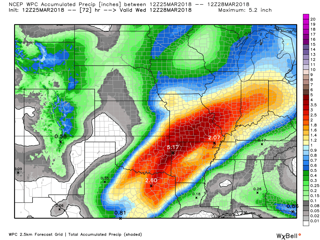
Forecast: Cloudy. Scattered showers. Windy. An isolated thunderstorm possible. Some of the rain could be moderate to heavy across southeast Missouri and southwest Illinois.
Temperatures: MO ~ 50 to 55 IL ~ 50 to 54 KY ~ 48 to 54 TN ~ 50 to 55
What is the chance of precipitation? MO ~ 70% western parts of southeast Missouri and 50% eastern sections IL ~ 40% KY ~ 40% for far western Kentucky and 30% for the Pennyrile area. TN ~ 40%
Coverage of precipitation: Scattered
Winds: South and southeast 10 to 20 mph and gusty
What impacts are anticipated from the weather? Wet roadways. Small chance of lightning over southeast Missouri and southwest Illinois. Moderate to heavy downpours.
My confidence in the forecast verifying: Medium
Is severe weather expected? Unlikely
The NWS defines severe weather as 58 mph wind or great, 1″ hail or larger, and/or tornadoes
Should I cancel my outdoor plans? Have a plan B and monitor updates.
Sunset 7:11 PM
March 27, 2018
Tuesday Forecast Details
Forecast: Cloudy. Showers and thunderstorms possible. Windy. Some of the rain could be moderate to heavy across southeast Missouri and southern Illinois.
Temperatures: MO ~ 63 to 66 IL ~ 63 to 66 KY ~ 64 to 68 TN ~ 64 to 68
What is the chance of precipitation? MO ~ 80% IL ~ 70% KY ~ 60% for far western Kentucky and 40% for the Pennyrile area into northwest Kentucky. TN ~ 40%
Coverage of precipitation: Widespread across southeast Missouri and southern Illinois. Scattered for western Kentucky and Tennessee.
Winds: South 10 to 20 mph with higher gusts
What impacts are anticipated from the weather? Wet roadways. Lightning. Moderate to heavy downpours possible.
My confidence in the forecast verifying: Medium
Is severe weather expected? Unlikely, but monitor updates.
The NWS defines severe weather as 58 mph wind or great, 1″ hail or larger, and/or tornadoes
Should I cancel my outdoor plans? Have a plan B and monitor updates.
Sunrise 6:47 AM
Tuesday Night Forecast Details:
Forecast: Cloudy. Rain. I can’t rule out a thunderstorm.
Temperatures: MO ~ 46 to 54 IL ~ 46 to 54 KY ~ 50 to 55 TN ~ 50 to 55
What is the chance of precipitation? MO ~ 70% IL ~ 70% KY ~ 70% TN ~ 70%
Coverage of precipitation: Widespread
Winds: South winds becoming southwest and west at 10 to 20 mph
What impacts are anticipated from the weather? Wet roadways. Moderate to heavy downpours possible. Lightning possible (although instability might be lacking).
My confidence in the forecast verifying: Medium
Is severe weather expected? Unlikely
The NWS defines severe weather as 58 mph wind or great, 1″ hail or larger, and/or tornadoes
Should I cancel my outdoor plans? Have a plan B.
Sunset 7:12 PM
March 28, 2018
Wednesday Forecast Details
Forecast: Mostly cloudy. Rain likely. Rain may taper from west to east during the day.
Temperatures: MO ~ 56 to 62 IL ~ 56 to 62 KY ~ 56 to 64 TN ~ 56 to 62
What is the chance of precipitation? MO ~ 50% IL ~ 60% KY ~ 70% TN ~ 70%
Coverage of precipitation: Scattered to perhaps widespread
Winds: West and northwest at 6 to 12 mph
What impacts are anticipated from the weather? Wet roadways.
My confidence in the forecast verifying: Medium
Is severe weather expected? Unlikely
The NWS defines severe weather as 58 mph wind or great, 1″ hail or larger, and/or tornadoes
Should I cancel my outdoor plans? Monitor updates
Sunrise 6:45 AM
Wednesday Night Forecast Details:
Forecast: Cloudy. Showers and thunderstorms possible.
Temperatures: MO ~ 43 to 46 IL ~ 43 to 46 KY ~ 46 to 50 TN ~ 46 to 50
What is the chance of precipitation? MO ~ 30% IL ~ 30% KY ~ 40% TN ~ 40%
Coverage of precipitation: Scattered
Winds: Variable 5 to 10 mph
What impacts are anticipated from the weather? Wet roadways. Lightning.
My confidence in the forecast verifying: Medium
Is severe weather expected? No
The NWS defines severe weather as 58 mph wind or great, 1″ hail or larger, and/or tornadoes
Should I cancel my outdoor plans? Monitor updates
Sunset 7:13 PM


