3:15 PM
I am monitoring this area for a couple of thunderstorms that could become intense.
3 PM
A couple of storms this evening could produce gusty winds and hail. Not sure how much development we see. Isolated severe risk.
2 PM
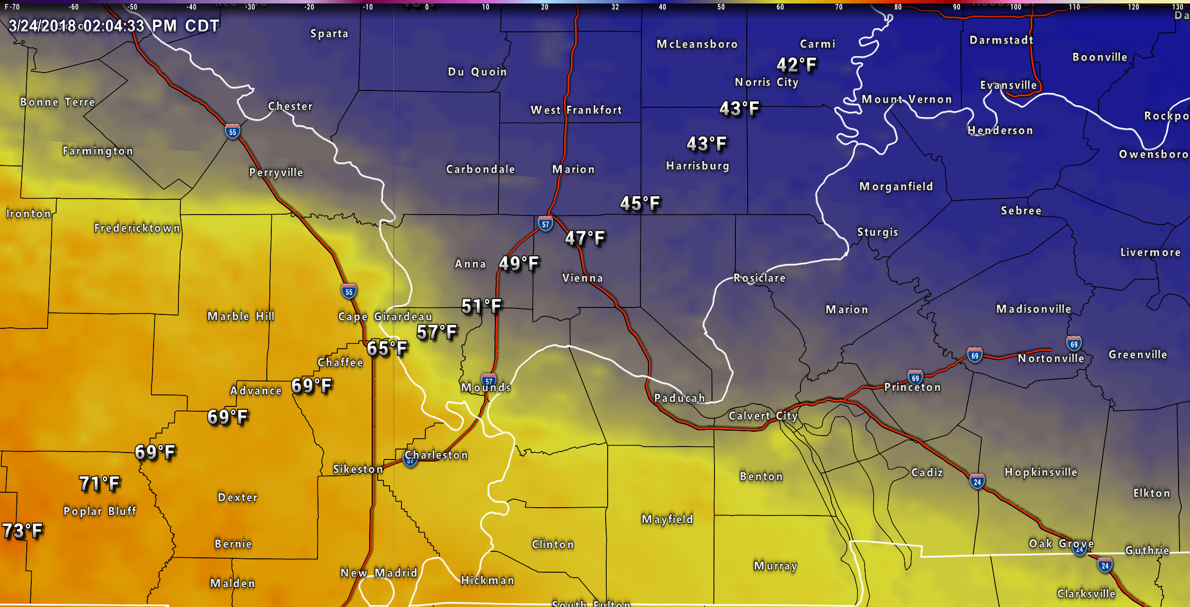
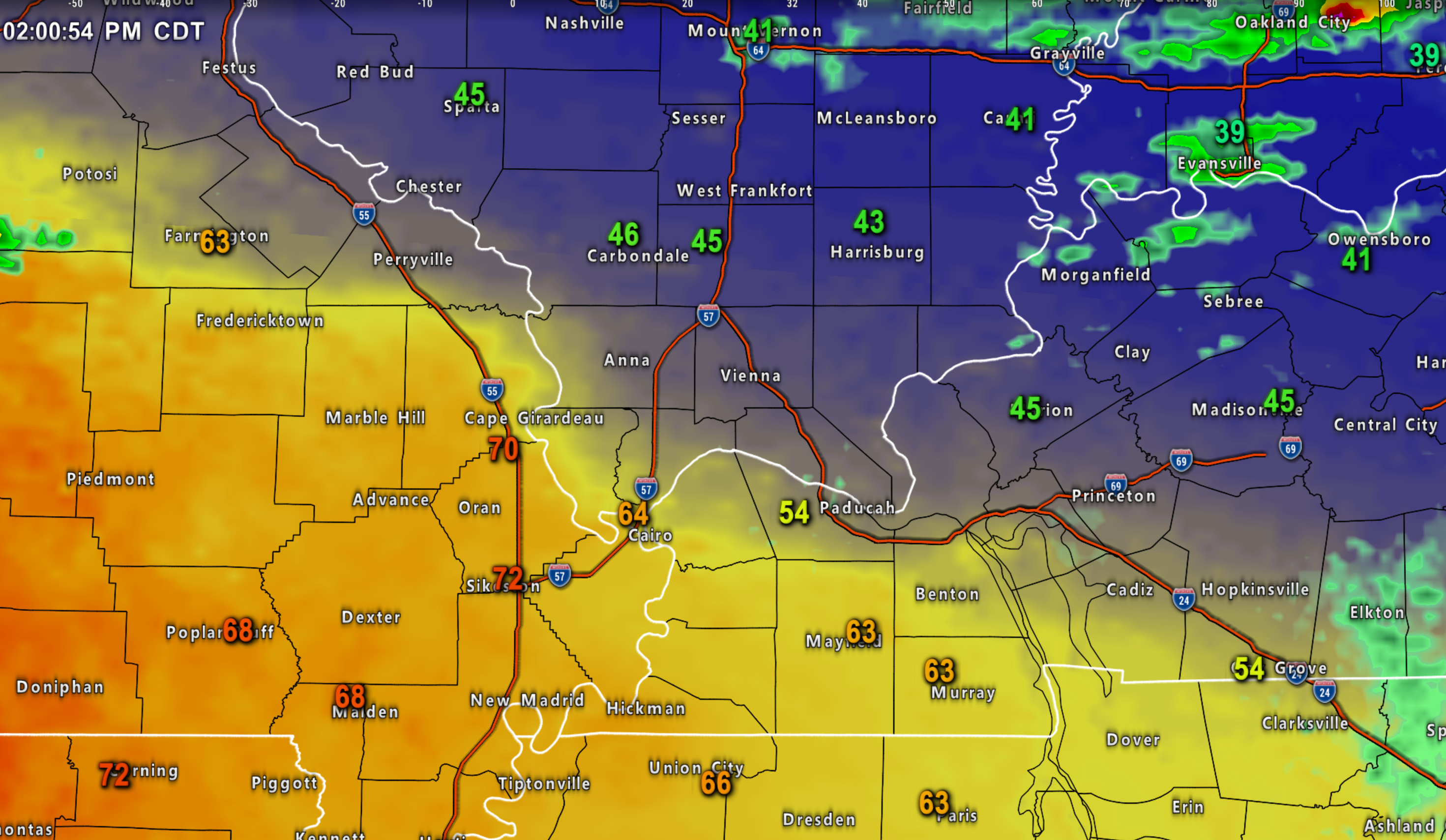
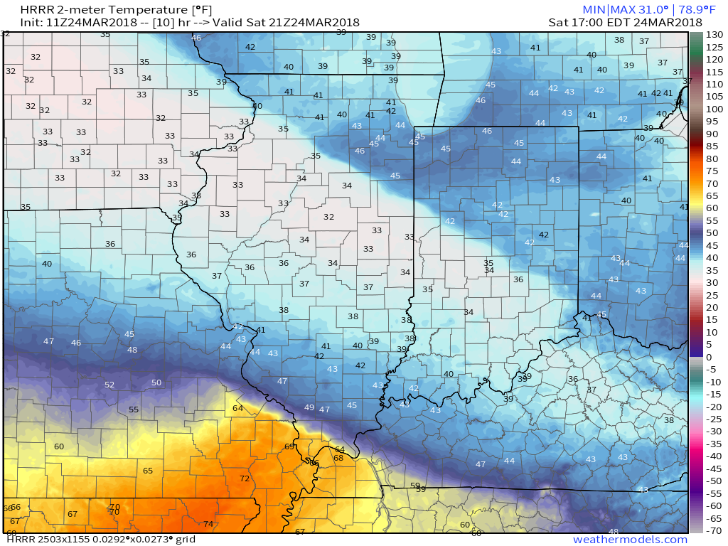
Check out this crazy temperature gradient.
A quick Saturday update.
I continue to struggle with forecasting rain coverage from Sparta, Illinois, to Paducah, Kentucky, to Murray, Kentucky. Along and west of that line.
Morning storms continue to track eastward. Some additional showers and perhaps a thunderstorms could develop in the warm sector of this system. That would be across southeast Missouri, southwest Illinois, and western Kentucky/northwest Tennessee.
The question is how much rain.
Widespread rain will occur over the northern parts of southern Illinois into southeast Illinois and then into northwest Kentucky and the Pennyrile area of western Kentucky.
WIDE range of temperatures today. We could see 70 degrees over portions of southeast Missouri and then 40’s across parts of southern Illinois and western Kentucky.
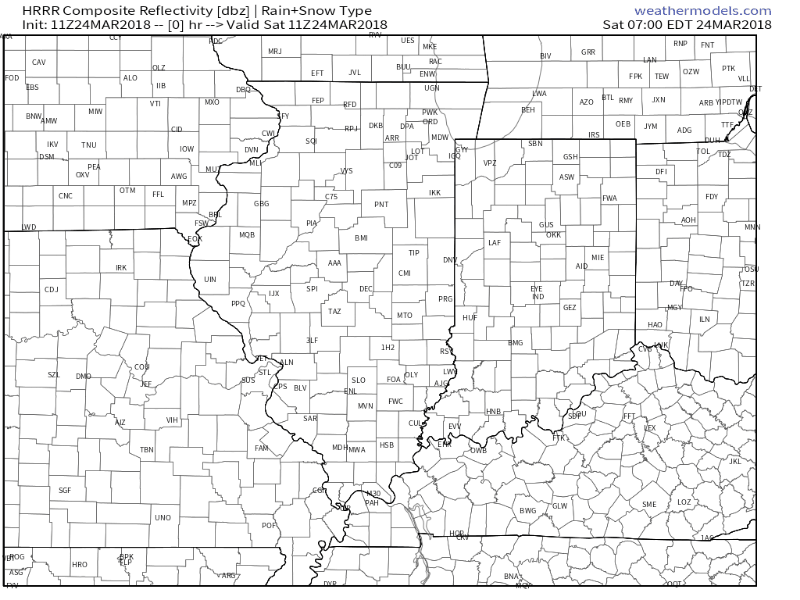
Here is the Hrrr model guidance future-cast radar and temperatures. This will take us into this afternoon.
Notice the heavy snow (blue) to our north and northeast.
Check out that amazing temperature gradient.
Temperatures

Static image of temps this afternoon
Radars:
Interactive live weather radar page. Choose the city nearest your location. If one of the cities does not work then try a nearby one. Click here.
March 24, 2018
This is a complicated forecast. I will break it down by state.
Saturday Forecast Details
Forecast:
LOW confidence on temperatures Saturday. Let’s just get that out of the way! I will give it my best shot.
Guidance is indicating morning showers are likely, but then coverage may diminish with time from west to east. Areas along and west of a line from Sparta, IL to Paducah, KY to Murray, KY may see less coverage as we move past 9 or 10 AM.
Some areas may remain dry most of the day.
To the northeast, there will be widespread rain.
A couple of thunderstorms could be intense with high winds and hail this evening.
Southeast Missouri: Mostly cloudy. We may have some breaks in the clouds from time to time. Warm. Breezy. A 50% of scattered showers and thunderstorms before 12 PM and then a 40% chance after 1 PM. High temperatures 64 to 74 degrees (if we have a bit more sun then some middle 70’s are not out of the question). Winds becoming south and southwest and eventually west at 10 to 20 mph. Gusty winds possible.
Southwest Illinois: Mostly cloudy. Some breaks in the clouds possible. An 60% of scattered showers and thunderstorms before 12 PM and then 30% after 1 AM. High 50 to 55 in the Randolph County area and then 48 to 58 degrees in the Carbondale and Cairo, Illinois area. There could be a wide range of temperatures depending on where the warm front is placed. Higher than normal potential for the temperature forecast to bust. South and southwest winds becoming west at 10 to 20 mph. Winds near the front will be in the 6 to 12 mph range.
Southeast Illinois: Mostly cloudy. Rain likely. A rumble of thunder possible. Bulk of the rain will be before 1 PM and then becoming more scattered during the afternoon. Cool. High 38 to 46. Wide range of temperatures. Temperatures will depend on the placement of the warm front. East and southeast winds at 10 to 20 mph. Winds near the front will only be in the 6 to 12 mph range.
Northwest Kentucky and the Pennyrile area of western Kentucky: Cloudy. Rain likely. Thunder possible. Cool. Bulk of the rain before 3 PM and then becoming more scattered late in the day. High 44 to 55. Wide range of temperatures. Higher than normal risk of the temperature forecast busting. If the warm front is further north and east then warmer temperatures will occur. East and southeast winds at 10 to 20 mph. Winds near the front will only be in the 6 to 12 mph range.
Far western Kentucky and northwest Tennessee: Mostly cloudy. Some breaks in the clouds possible. Rain showers and some thunderstorms likely before 11 AM. Rain becoming increasingly scattered the later into the day we move. Bulk of the rain will likely be before 11 AM. Wide range of temperatures possible. Highs 58 to 64. Again, high chance of a temperature bust. Meaning it could be cooler or warmer depending on the placement of the warm front. Southeast and south winds becoming southwest at 10 to 20 mph. Winds near the front will be lighter.
Coverage of precipitation: Scattered to widespread depending on the path of the area of low pressure. Rain coverage will be least in the Poplar Bluff, MO area and greatest in southeast Illinois, northwest Kentucky, and the Pennyrile of western Kentucky. Some areas may remain dry most of the day. The further west you travel the greater the chance of dry weather.
Winds: South and southwest at 10 to 20 mph. Becoming west at 10 to 20 mph and gusty.
What impacts are anticipated from the weather? Wet roadways. Lightning. Small hail.
My confidence in the forecast verifying: LOW confidence on temperatures. Medium confidence on rain chances.
Is severe weather expected? Unlikely. Risk for pea to dime size hail.
The NWS defines severe weather as 58 mph wind or great, 1″ hail or larger, and/or tornadoes
Should I cancel my outdoor plans? Have a plan B and monitor the radars.
Sunrise 6:51 AM
Saturday Night Forecast Details:
Forecast: Cloudy. A few remaining showers possible. Rain ending west to east. Turning colder.
Temperatures: MO ~ 34 to 40 IL ~ 34 to 38 KY ~ 38 to 44 TN ~ 40 to 45
What is the chance of precipitation? MO ~ 30% IL ~ 30% KY ~ 40% TN ~ 40%
Coverage of precipitation: Becoming scattered
Winds: Winds becoming west and northwest area-wide.
What impacts are anticipated from the weather? Wet roadways. Perhaps lightning early in the evening.
My confidence in the forecast verifying: Medium
Is severe weather expected? Unlikely
The NWS defines severe weather as 58 mph wind or great, 1″ hail or larger, and/or tornadoes
Should I cancel my outdoor plans? Have a plan B early and then monitor radars.
Sunset 7:09 PM
March 25, 2018
Sunday Forecast Details
Forecast: A mix of sun and clouds. A slight chance of a shower.
Temperatures: MO ~ 53 to 56 IL ~ 53 to 56 KY ~ 54 to 58 TN ~ 55 to 60
What is the chance of precipitation? MO ~ 20% IL ~ 20% KY ~20% TN ~ 20%
Coverage of precipitation: Isolated to widely scattered.
Winds: East and northeast at 5 to 10 mph
What impacts are anticipated from the weather? Isolated wet roadways. Believe it will mostly be dry.
My confidence in the forecast verifying: High
Is severe weather expected? No
The NWS defines severe weather as 58 mph wind or great, 1″ hail or larger, and/or tornadoes
Should I cancel my outdoor plans? No
Sunrise 6:50 AM
Sunday Night Forecast Details:
Forecast: Becoming cloudy. A few showers developing.
Temperatures: MO ~ 38 to 44 IL ~ 38 to 44 KY ~ 40 to 45 TN ~ 44 to 45
What is the chance of precipitation? MO ~ 30% IL ~ 20% KY ~ 20% TN ~ 20%
Coverage of precipitation: Isolated
Winds: East at 4 to 8 mph
What impacts are anticipated from the weather? Wet roadways.
My confidence in the forecast verifying: Medium
Is severe weather expected? No
The NWS defines severe weather as 58 mph wind or great, 1″ hail or larger, and/or tornadoes
Should I cancel my outdoor plans? Monitor updates
Sunset 7:10 PM
March 26, 2018
Monday Forecast Details
Forecast: Cloudy. Rain increasing southwest to northeast as the day wears on. Lightning possible.
Temperatures: MO ~ 58 to 64 IL ~ 58 to 64 KY ~ 58 to 64 TN ~ 58 to 64
What is the chance of precipitation? MO ~ 70% IL ~ 70% KY ~60% TN ~ 60%
Coverage of precipitation: Scattered to perhaps widespread
Winds: South and southeast 8 to 16 mph with gusts to 20 mph
What impacts are anticipated from the weather? Wet roadways. Lightning.
My confidence in the forecast verifying: High
Is severe weather expected? Unlikely
The NWS defines severe weather as 58 mph wind or great, 1″ hail or larger, and/or tornadoes
Should I cancel my outdoor plans? Have a plan B and monitor updates.
Sunrise 6:48 AM
Monday Night Forecast Details:
Forecast: Cloudy. Scattered showers. Windy. An isolated thunderstorm possible. Some of the rain could be moderate to heavy across southeast Missouri and southwest Illinois.
Temperatures: MO ~ 50 to 55 IL ~ 50 to 54 KY ~ 48 to 54 TN ~ 50 to 55
What is the chance of precipitation? MO ~ 70% western parts of southeast Missouri and 50% eastern sections IL ~ 40% KY ~ 40% for far western Kentucky and 30% for the Pennyrile area. TN ~ 40%
Coverage of precipitation: Scattered
Winds: South and southeast 10 to 20 mph and gusty
What impacts are anticipated from the weather? Wet roadways. Small chance of lightning over southeast Missouri and southwest Illinois. Moderate to heavy downpours.
My confidence in the forecast verifying: Medium
Is severe weather expected? Unlikely
The NWS defines severe weather as 58 mph wind or great, 1″ hail or larger, and/or tornadoes
Should I cancel my outdoor plans? Have a plan B and monitor updates.
Sunset 7:11 PM
March 27, 2018
Tuesday Forecast Details
Forecast: Cloudy. Showers and thunderstorms possible. Windy. Some of the rain could be moderate to heavy across southeast Missouri and southern Illinois.
Temperatures: MO ~ 63 to 66 IL ~ 63 to 66 KY ~ 64 to 68 TN ~ 64 to 68
What is the chance of precipitation? MO ~ 80% IL ~ 70% KY ~ 60% for far western Kentucky and 40% for the Pennyrile area into northwest Kentucky. TN ~ 40%
Coverage of precipitation: Widespread across southeast Missouri and southern Illinois. Scattered for western Kentucky and Tennessee.
Winds: South 10 to 20 mph with higher gusts
What impacts are anticipated from the weather? Wet roadways. Lightning. Moderate to heavy downpours possible.
My confidence in the forecast verifying: Medium
Is severe weather expected? Unlikely, but monitor updates.
The NWS defines severe weather as 58 mph wind or great, 1″ hail or larger, and/or tornadoes
Should I cancel my outdoor plans? Have a plan B and monitor updates.
Sunrise 6:47 AM
Tuesday Night Forecast Details:
Forecast: Cloudy. Rain. I can’t rule out a thunderstorm.
Temperatures: MO ~ 46 to 54 IL ~ 46 to 54 KY ~ 50 to 55 TN ~ 50 to 55
What is the chance of precipitation? MO ~ 70% IL ~ 70% KY ~ 70% TN ~ 70%
Coverage of precipitation: Widespread
Winds: South winds becoming southwest and west at 10 to 20 mph
What impacts are anticipated from the weather? Wet roadways. Moderate to heavy downpours possible. Lightning possible (although instability might be lacking).
My confidence in the forecast verifying: Medium
Is severe weather expected? Unlikely
The NWS defines severe weather as 58 mph wind or great, 1″ hail or larger, and/or tornadoes
Should I cancel my outdoor plans? Have a plan B.
Sunset 7:12 PM
March 28, 2018
Wednesday Forecast Details
Forecast: Mostly cloudy. Rain likely. Rain may taper from west to east during the day.
Temperatures: MO ~ 56 to 62 IL ~ 56 to 62 KY ~ 56 to 64 TN ~ 56 to 62
What is the chance of precipitation? MO ~ 50% IL ~ 60% KY ~ 70% TN ~ 70%
Coverage of precipitation: Scattered to perhaps widespread
Winds: West and northwest at 6 to 12 mph
What impacts are anticipated from the weather? Wet roadways.
My confidence in the forecast verifying: Medium
Is severe weather expected? Unlikely
The NWS defines severe weather as 58 mph wind or great, 1″ hail or larger, and/or tornadoes
Should I cancel my outdoor plans? Monitor updates
Sunrise 6:45 AM
Wednesday Night Forecast Details:
Forecast: Cloudy. Showers and thunderstorms possible.
Temperatures: MO ~ 43 to 46 IL ~ 43 to 46 KY ~ 46 to 50 TN ~ 46 to 50
What is the chance of precipitation? MO ~ 30% IL ~ 30% KY ~ 40% TN ~ 40%
Coverage of precipitation: Scattered
Winds: Variable 5 to 10 mph
What impacts are anticipated from the weather? Wet roadways. Lightning.
My confidence in the forecast verifying: Medium
Is severe weather expected? No
The NWS defines severe weather as 58 mph wind or great, 1″ hail or larger, and/or tornadoes
Should I cancel my outdoor plans? Monitor updates
Sunset 7:13 PM
![]()
Interactive live weather radar page. Choose the city nearest your location. If one of the cities does not work then try a nearby one. Click here.
National map of weather watches and warnings. Click here.
Storm Prediction Center. Click here.
Weather Prediction Center. Click here.

Live lightning data: Click here.