Would you like to subscribe? Subscribe at www.weathertalk.com
.
Click one of the links below to take you directly to each section.
- Go to today’s forecast
- Go to the severe weather outlook
- Go to the weather forecast discussion
- Go to the model future-cast radars
- Go to Weatherbrains
- View some of our charity work. Your subscription dollars help support these causes.
Do you have questions or suggestions? If so, please email me. Beaudodson@usawx.com
.
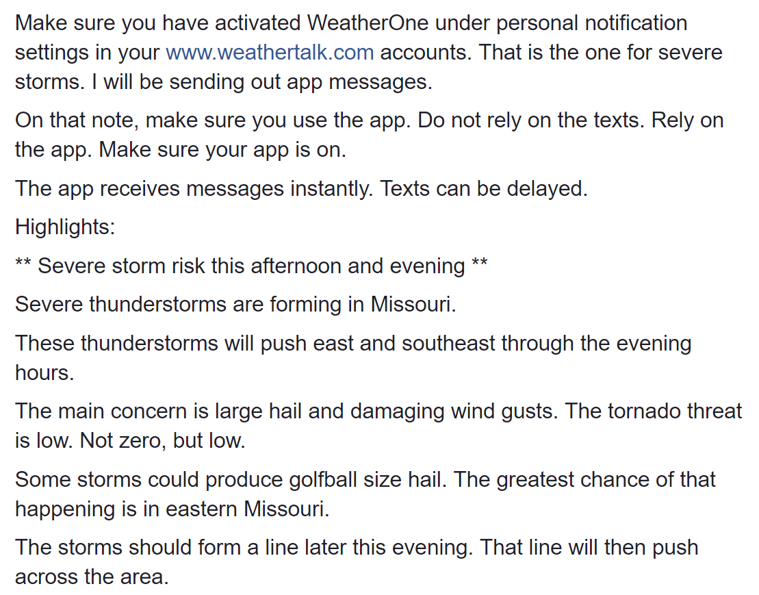
4 PM Update
Severe weather Facebook Q&A Link https://wtalk.co/J
Severe thunderstorms are forming in Missouri
Radars
http://weatherobservatory.com/weather-radar.htm
.
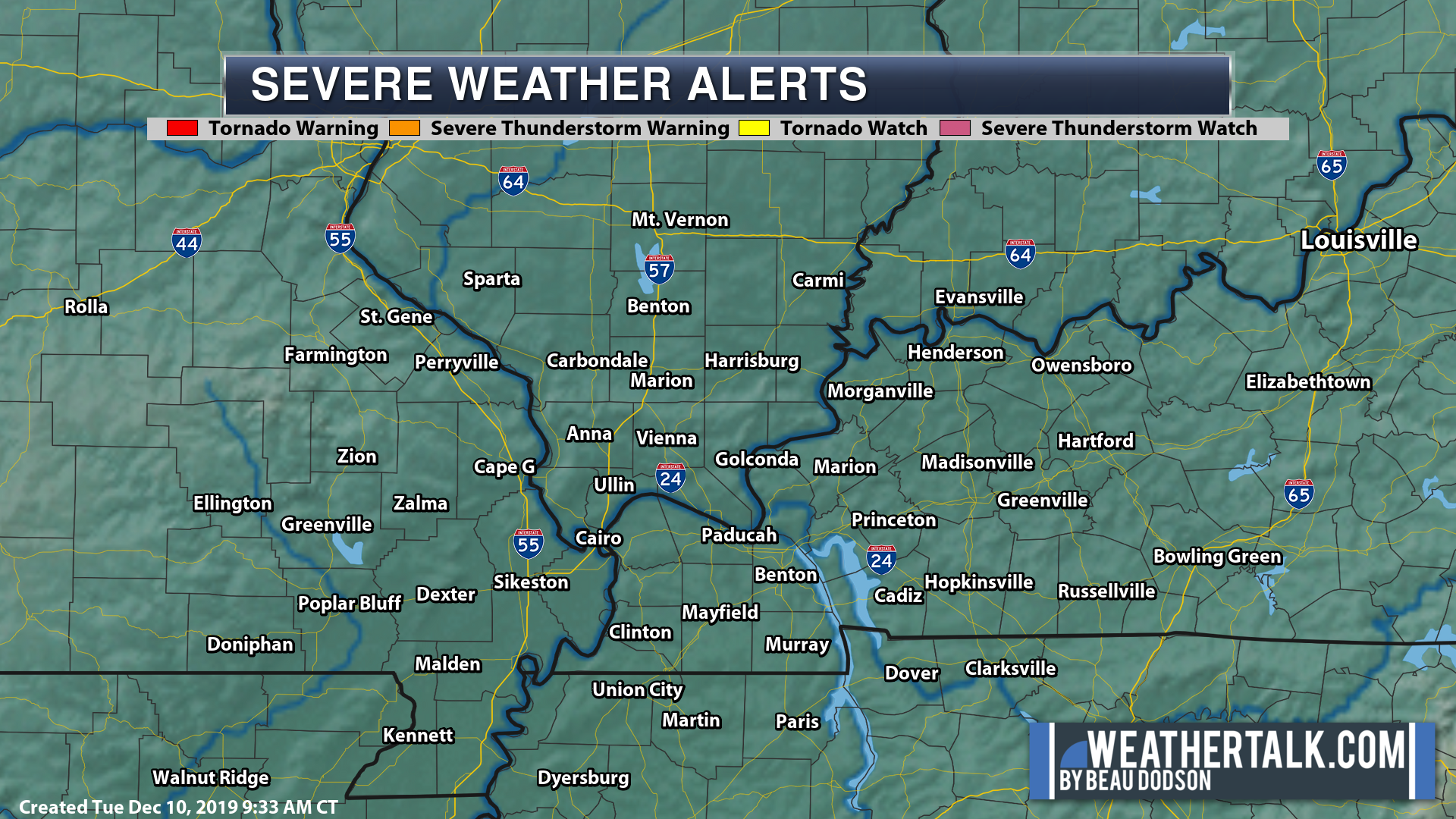
Severe weather warnings
https://imagery.weathertalk.com/prx/LocalSevereAlerts.png
.
.
11 AM update
Track the storms
Radar Link: Interactive local city-view radars & regional radars.
The risk of severe weather is increasing. The sun is out over quite a large chunk of our region. The further west you travel the more sun you will encounter.
This is heating up the ground. That is causing the atmosphere to become more unstable.
The greatest risk today is over southeast Missouri and southwest Illinois.
A few reports of golf ball size hail cannot be ruled out. The Storm Prediction Center has mentioned 2″ size hail as possible.
There could also be damaging wind gusts. The tornado risk is low.
Thunderstorms will rapidly develop this afternoon ahead of a cold front.
Those storms will first form over southeast Missouri. They will likely form between 1 and 3 PM. They would then move east/southeast.
The storms may be supercells at first. They would then develop into a line of thunderstorms.
The greatest risk of large hail will be while the storms are supercells. That would be over southeast Missouri and southwest Illinois.
Monitor watches and warnings.
I will be sending out app messages (I already am).
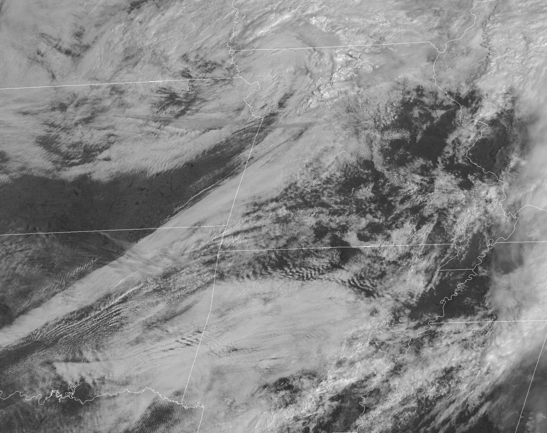
Here is the visible satellite image. Notice all the sun? Clouds are white.
CAPE is building. CAPE is energy for thunderstorms to tap into.
Click to enlarge the image.
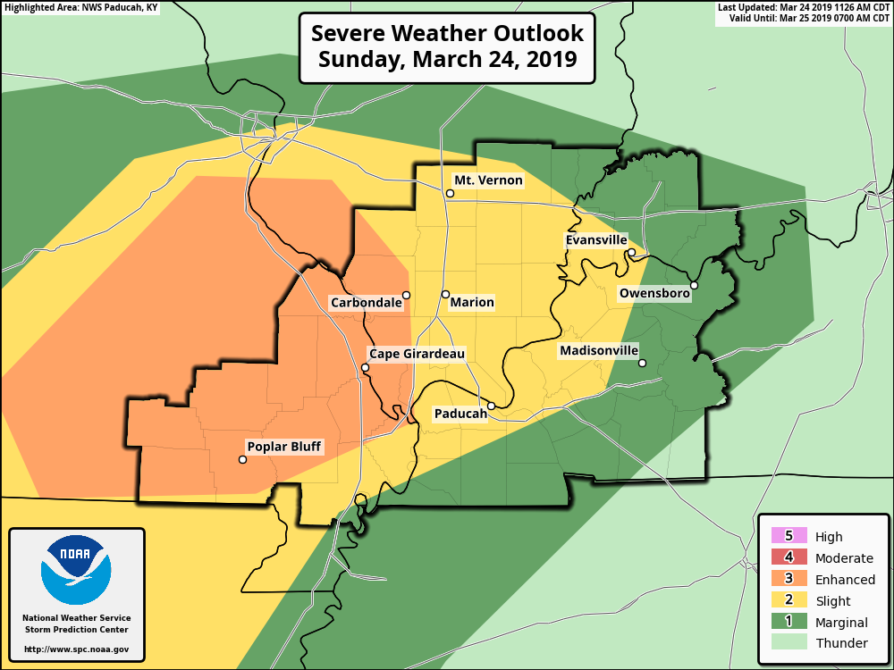
Here is the updated SPC outlook. Orange is the highest risk on this map. It is a level three out of five risk. Yellow is one level below the orange. Dark green is a marginal level 1 out of 5 risk.
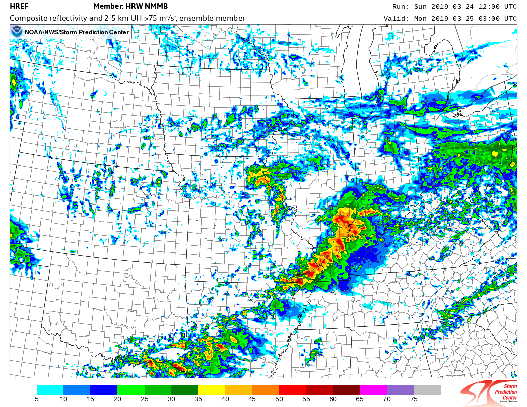
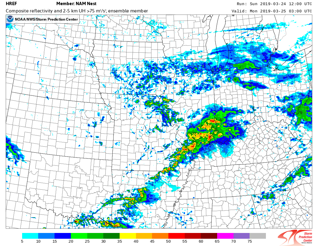
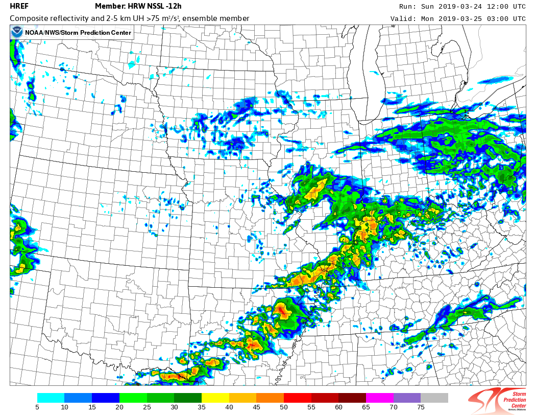
CAMS (high res models) all show thunderstorms forming late this afternoon and evening.
Here is what some of them show. These are different models. They are all showing the same idea.
These are all after 8 PM tonight.
There remains some uncertainty on the exact time storms will move into southern IL and western KY/NW TN.
Southeast Missouri will experience them first.
This is just showing you ONE snapshot of the storms. They would occur before this time and west of these images, as well.
I am just showing you one time period.

- Rain today. A lull late morning into early afternoon. Thunderstorms mid-afternoon into tonight.
- A few storms could produce hail and strong winds. Hail is the main concern today. Greatest risk is over southeast Missouri and southwest Illinois. Lesser risk elsewhere.
.
.

Today: Yes. Monitor radars and forecasts. A couple of storms could produce hail and gusty winds.
.
Tomorrow: No.
.

Confidence rating explained.
- High confidence is 70% to 100%. This means that the forecast is likely to verify.
- Medium confidence is 40% through 60%. This means that there could be adjustments in the forecast.
- Low confidence is 0% to 30%. This means that dramatic changes in the forecast are likely.
Click here if you would like to return to the top of the page

Today through Tuesday night.
- Is accumulating snow or ice in the forecast? No.
- Is lightning in the forecast? Yes. Lightning is possible this afternoon into tonight.
- Is severe weather in the forecast? Yes. Mainly over southeast Missouri and southern Illinois. Lesser risk elsewhere. A few storms could produce hail. A few storms could produce strong winds, as well. The best chance of strong storms will be over southeast Missouri and southwest Illinois. As always, monitor updates.
* The NWS officially defines severe weather as 58 mph wind or great, 1″ hail or larger, and/or tornadoes - Is Flash flooding in the forecast? No. General river flooding will continue.

Wednesday through Saturday
- Is accumulating snow or ice in the forecast? No.
- Is lightning in the forecast? Possible. A few storms are possible on Friday or Saturday.
- Is severe weather in the forecast? At this time, no.
* The NWS officially defines severe weather as 58 mph wind or great, 1″ hail or larger, and/or tornadoes - Is flash flooding in the forecast? No. General river flooding will continue.
* The Missouri Bootheel includes Dunklin, New Madrid, and Pemiscot Counties
* Northwest Kentucky includes Daviess, Henderson, McLean Union, and Webster Counties
.
Today’s Facebook weather discussion link
Click here
March 24, 2019
Abbreviated weekend update
Radar Link: Interactive local city-view radars & regional radars.
Sunday’s Forecast: Morning showers. A lull in the precipitation is possible late morning into early or mid-afternoon. Thunderstorms developing during the mid to late afternoon over SE MO spreading E SE. A few storms could be strong with hail and gusty winds. Rain totals Sunday to Monday in the 0.30″ to 0.60″ range. Locally higher if thunderstorms occur.
My confidence in the forecast verifying: High (80% confidence in the forecast))
Temperature range: MO Bootheel 64° to 68° SE MO 63° to 66° South IL 60° to 65° Northwest KY (near Indiana border) 60° to 64° West KY 62° to 65° NW TN 64° to 68°
Wind direction and speed: South and southwest at 10 to 20 mph and gusty
Wind chill or heat index (feels like) temperature forecast: 58° to 64°
What is the chance/probability of precipitation? MO Bootheel 80% Southeast MO 70% IL 80% Northwest KY (near Indiana border) 80% Western KY 80% NW TN 80%
Note, what does the % chance actually mean? A 20% chance of rain does not mean it won’t rain. It simply means most areas will remain dry.
Coverage of precipitation: Numerous AM showers. Thunderstorms developing during the mid to late afternoon over SE MO spreading E SE
What impacts are anticipated from the weather? Wet roadways. Lightning possible. A few reports of hail possible. Smaller risk of damaging winds. Tornado risk is low.
Should I cancel my outdoor plans? Have a plan B. Monitor radars.
UV Index: 2 Low
Sunrise: 6:53 AM
.
Sunday night Forecast: Cloudy. Rain likely. A chance of thunderstorms. Some storms could be strong during the evening hours with hail and gusty winds.
My confidence in the forecast verifying: High (80% confidence in the forecast)
Temperature range: MO Bootheel 48° to 52° SE MO 46° to 50° South IL 48° to 52° Northwest KY (near Indiana border) 48° to 52° West KY 38° to 42° NW TN 48° to 52°
Wind direction and speed: South 8 to 16 mph and gusty. Winds switching more to the west and northwest late.
Wind chill or heat index (feels like) temperature forecast: 40° to 50°
What is the chance/probability of precipitation? MO Bootheel 70% Southeast MO 70% Southern IL 80% Northwest KY (near Indiana border) 80% Western KY 80% NW TN 80%
Note, what does the % chance actually mean? A 20% chance of rain does not mean it won’t rain. It simply means most areas will remain dry
Coverage of precipitation: Numerous
What impacts are anticipated from the weather? Wet roadways. Lightning possible. A few reports of hail and wind are possible.
Should I cancel my outdoor plans? Have a plan B.
Sunset: 7:10 PM
Moonrise: 11:28 PM
The phase of the moon: Waning Gibbous
Moonset: 9:24 AM
March 25, 2019
Monday’s Forecast: Cloudy. Morning showers coming to an end west to east as the day wears on. Patchy drizzle is possible. Windy.
My confidence in the forecast verifying: High (70% confidence in the forecast))
Temperature range: MO Bootheel 54° to 58° SE MO 53° to 56° South IL 53° to 56° Northwest KY (near Indiana border) 53° to 56° West KY 54° to 56° NW TN 54° to 58°
Wind direction and speed: North and northwest at 15 to 25 mph and gusty.
Wind chill or heat index (feels like) temperature forecast: 45° to 50°
What is the chance/probability of precipitation? MO Bootheel 30% Southeast MO 30% IL 40% Northwest KY (near Indiana border) 50% Western KY 50% NW TN 40%
Note, what does the % chance actually mean? A 20% chance of rain does not mean it won’t rain. It simply means most areas will remain dry.
Coverage of precipitation: Scattered early. Ending west to east.
What impacts are anticipated from the weather? Wet roadways. Gusty winds.
Should I cancel my outdoor plans? Monitor morning radars.
UV Index: 2 to 3 Low to moderate
Sunrise: 6:52 AM
.
Monday night Forecast: Quite a few clouds over most of the area. Patchy drizzle ending. Some clearing overnight (esp north). Chilly. A freeze is possible. A small chance of a sprinkle early in the night.
My confidence in the forecast verifying: High (70% confidence in the forecast)
Temperature range: MO Bootheel 34° to 36° SE MO 30° to 34° South IL 28° to 34° Northwest KY (near Indiana border) 30° to 34° West KY 30° to 34° NW TN 34° to 38°
Wind direction and speed: North 8 to 16 mph
Wind chill or heat index (feels like) temperature forecast: 20° to 30°
What is the chance/probability of precipitation? MO Bootheel 0% Southeast MO 0% Southern IL 10% Northwest KY (near Indiana border) 10% Western KY 10% NW TN 10%
Note, what does the % chance actually mean? A 20% chance of rain does not mean it won’t rain. It simply means most areas will remain dry
Coverage of precipitation: Most likely none
What impacts are anticipated from the weather? A light freeze is possible.
Should I cancel my outdoor plans? No
Sunset: 7:11 PM
Moonrise: 11:59 PM
The phase of the moon: Waning Gibbous
Moonset: 10:03 AM
March 26, 2019
Tuesday’s Forecast: Partly cloudy. Cool. Breezy.
My confidence in the forecast verifying: Medium (60% confidence in the forecast))
Temperature range: MO Bootheel 52° to 54° SE MO 50° to 55° South IL 50° to 55° Northwest KY (near Indiana border) 52° to 54° West KY 52° to 54° NW TN 53° to 56°
Wind direction and speed: North and northeast at 10 to 20 mph and gusty.
Wind chill or heat index (feels like) temperature forecast: 40° to 50°
What is the chance/probability of precipitation? MO Bootheel 0% Southeast MO 0% IL 0% Northwest KY (near Indiana border) 0% Western KY 0% NW TN 0%
Note, what does the % chance actually mean? A 20% chance of rain does not mean it won’t rain. It simply means most areas will remain dry.
Coverage of precipitation: None
What impacts are anticipated from the weather? None
Should I cancel my outdoor plans? None
UV Index: 2 to 3 Low to moderate
Sunrise: 6:52 AM
.
Tuesday night Forecast: Mostly clear. Chilly. A chance of frost or a light freeze.
My confidence in the forecast verifying: High (70% confidence in the forecast)
Temperature range: MO Bootheel 30° to 34° SE MO 30° to 34° South IL 28° to 34° Northwest KY (near Indiana border) 30° to 34° West KY 30° to 34° NW TN 32° to 34°
Wind direction and speed: East and northeast at 4 to 8 mph
Wind chill or heat index (feels like) temperature forecast: 25° to 35°
What is the chance/probability of precipitation? MO Bootheel 0% Southeast MO 0% Southern IL 10% Northwest KY (near Indiana border) 10% Western KY 10% NW TN 10%
Note, what does the % chance actually mean? A 20% chance of rain does not mean it won’t rain. It simply means most areas will remain dry
Coverage of precipitation: None
What impacts are anticipated from the weather? A light freeze or frost is possible.
Should I cancel my outdoor plans? No
Sunset: 7:11 PM
Moonrise: 11:59 PM
The phase of the moon: Waning Gibbous
Moonset: 10:03 AM
Wednesday: Mostly sunny. Highs in the upper 50’s to lower 60’s. A few clouds Wednesday night with lows in the middle 40’s. Wind gusts to 10 mph
Thursday: Mostly sunny. Highs in the middle to upper 60’s. Gusty winds. Thursday night lows in the lower to middle 50’s. Wind gusts above 20 mph likely.
Friday: Partly sunny. A shower is possible. Highs in the middle to upper 60’s. Gusty winds. Showers possible Friday night. Lows in the lower to middle 50’s. Wind gusts above 20 mph likely.
Learn more about the UV index readings. Click here.
Graphic-cast
These graphic-forecasts may vary a bit from my forecast above.
Missouri


Illinois


Kentucky


Tennessee

Wind forecast
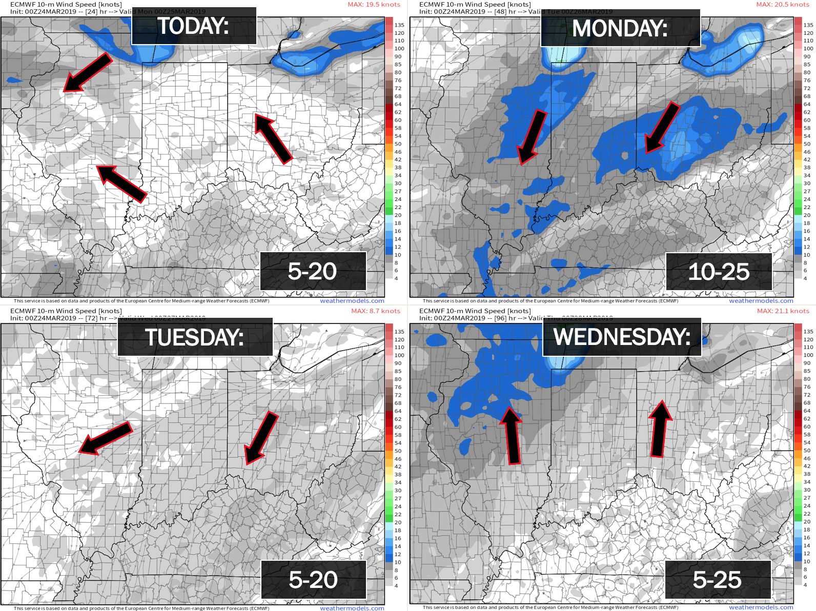
Sunday: S 10 to 20 with gusts to 25+
Sunday night: SW becoming W NW at 8 to 16 mph. Gusty.
Monday: West and northwest at 15 to 30 mph and gusty.
Monday night: North at 10 to 20 mph and gusty.

The National Weather Service defines a severe thunderstorm as one that produces quarter size hail or larger, 58 mph winds or greater, and/or a tornado.
Today and tomorrow: Thunderstorms are possible Sunday afternoon into Sunday night. A few storms could produce large hail (quarter size or so) and strong wind gusts. The greatest concern will be over southeast Missouri and southwest Illinois. Elsewhere, monitor updates.
Monday through Friday: Severe weather is not anticipated. I will monitor lightning chances Friday into Sunday.
.
Be sure and have WeatherOne turned on in your WeatherTalk accounts. That is the one for winter storms, ice storms, and severe weather.
Log into your www.weathertalk.com Click the personal notification settings tab. Turn on WeatherOne. Green is on. Red is off.

.

Here is the latest graphic from the WPC/NOAA.
This map shows you liquid and does not assume precipitation type. In other words, melted precipitation totals.
48-hour precipitation outlook.

Here is the seven-day precipitation forecast. This includes day one through seven.

Subscribers, do you need a forecast for an outdoor event?


Radar Link: Interactive local city-view radars & regional radars.
During winter weather be sure and click the winterize button above each city-view radar. This will show you the precipitation type.
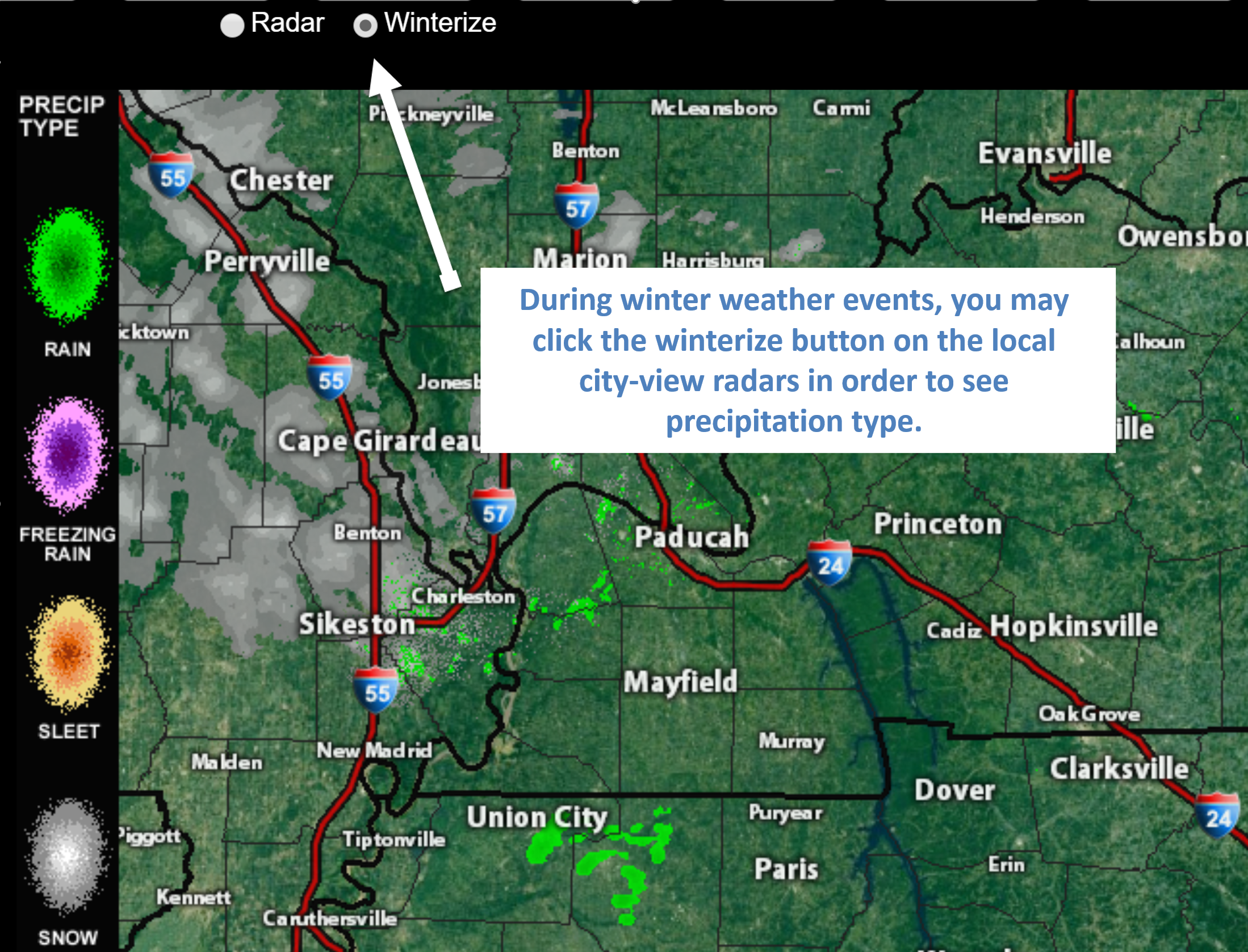
Click the image for an example of how to show winter precipitation type
You will also find clickable warning and advisory buttons on the local city-view radars.
If the radar is not updating then try another one. If a radar does not appear to be refreshing then hit Ctrl F5. You may also try restarting your browser.
Not working? Email me at beaudodson@usawx.com
National map of weather watches and warnings. Click here.
Weather Prediction Center. Click here..
.

Live lightning data: Click here.
.

Interactive GOES R satellite. Track clouds. Click here.
GOES 16 slider tool. Click here.
College of Dupage satellites. Click here
.

Here are the latest local river stage forecast numbers Click Here.
Here are the latest lake stage forecast numbers for Kentucky Lake and Lake Barkley Click Here.
.

- Rain showers this morning.
- Thunderstorms later today and this evening. Some thunderstorms could produce large hail and strong winds. The greatest concern is over southeast Missouri and southwest Illinois.
- Another system should bring showers and possibly a few thunderstorms next Friday/Saturday/Sunday. Plenty of time to monitor that event.
Current conditions.

.
Have there been any changes in the forecast over the last 24 hours?
No major changes. I did bump up temperatures a bit today.
Does the forecast require action?
Yes. Monitor Sunday afternoon and evening for a few strong thunderstorms with hail and strong winds. The highest chance of that occurring would be over southeast Missouri and southwest Illinois.
Yes. Avoid flooded roadways. Many rivers are flooding.
Click here if you would like to return to the top of the page
Forecast discussion.
A cold front is approaching the region. An area of low pressure will move southeast towards St Louis, Missouri, today.
We do have rain on the radar this morning. See radars.
Radar Link: Interactive local city-view radars & regional radars.
This mornings rain will push off to the east. That will leave us with clouds. Some clearing is possible by late morning and early afternoon. This is especially true across southeast Missouri and southwest Illinois.
That clearing will allow some instability to form. That instability will be fuel for thunderstorms by mid to late afternoon.
Thunderstorms will first develop over southeast Missouri. They will then expand east and southeast. Some of the storms could produce hail and strong winds. The tornado risk is low.
Some severe thunderstorm warnings are likely later today if thunderstorms develop as expected.
The risk of severe weather is lower over southeast Illinois, western Kentucky, and western Tennessee. The risk is not zero. Monitor updates through the afternoon and evening hours.
Here is the current SPC severe weather forecast.
Light green is sub-severe. Dark green is a level 1 out 5 risk. One being the lowest. Yellow is a level 2 risk.
.

https://www.spc.noaa.gov/public/cwa/images/PAH_swody1.png
.
Rain will continue into tonight. Rain will taper as we move into Monday morning.
Monday will deliver quite a few clouds, gusty winds, and some patchy light rain and drizzle.
Conditions dry out by Monday night. We will have temperatures dropping into the 30’s both Monday and Tuesday night. We may see some 20’s closer to Mt Vernon both nights.
A light freeze will be possible Monday and Tuesday night. Especially true from Poplar Bluff, Missouri, into much of southern Illinois, and northwest Kentucky.
Dry weather Tuesday, Wednesday, and Thursday.
A new storm system will approach our region by Friday and Saturday. That will deliver additional rain chances.
Click here if you would like to return to the top of the page
.
Model Future-cast Radars. What the models believe the radar may look like.
This is the Hrrr model guidance.
Green is rain. Yellow/orange represents heavier showers or thunderstorms.
This is a model so it won’t be exact. Take the general idea from it.
Timestamp upper left
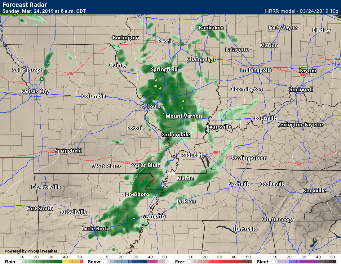
.
.Precipitation dates to monitor.
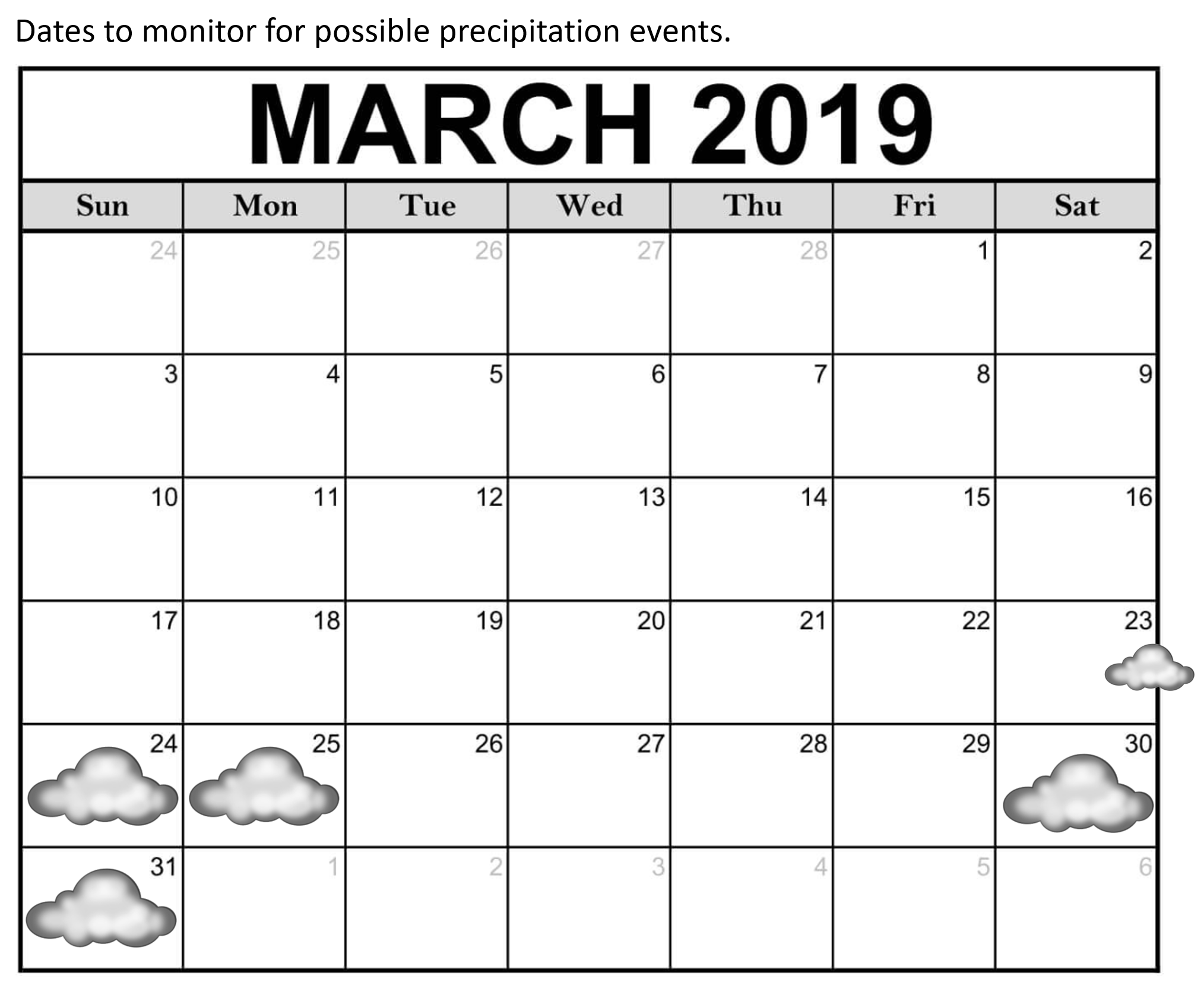
.
These maps update several times a day. Occasionally, in between updates, you may see a duplicate day or one out of sync.
Forty-eight-hour temperature outlook.


*****
end
![]()


.
Our Guest WeatherBrains tonight are geographers who study the intersections of physical science and social science as it relates to tornadoes and all meteorological hazards. Dr. Stephen Strader and Dr. Walker Ashley, welcome to the show!
Tonight’s first Guest Panelist is from the Carolina Weather Group Podcast. He spent 15 years as a professional firefighter. In 2017, he decided to start pursuing weather and started a blog. He joined Carolina Weather Group in 2018. Chris Jackson, welcome!
Also joining us as Guest Panelist is a Mississippi State University meteorology student who is also in charge of this year’s Southeast Severe Storms Symposium. Alex Forbes, welcome to WeatherBrains!
Other discussions in this weekly podcast include topics like:
- National Weather Podcast Month
- Vortex Southeast
- 2019 Southeast Severe Storms Symposium
- Correlation between mobile homes and tornado fatalities
- Mapping of mobile homes and utilizing it on-air during severe weather
- The Astronomy Report from Tony Rice
- and more!
.
.
.
Previous episodes can be viewed by clicking here.
.
Find Beau on Facebook! Click the banner.

.
Find Beau on Twitter! Share your weather photos! @beaudodson

Click here to go to the top of the page
Did you know that a portion of your monthly subscription helps support local charity projects? Not a subscriber? Becoming one at www.weathertalk.com
You can learn more about those projects by visiting the Shadow Angel Foundation website and the Beau Dodson News website.
