
Click one of the links below to take you directly to that section
![]()
![]()
![]()
![]()
![]()
![]()
![]()
.

.
Seven Day Hazardous Weather Outlook
1. Is lightning in the forecast? YES. Lightning is possible next Sunday night into Monday night. I will monitor Tuesday into Thursday.
2. Are severe thunderstorms in the forecast? MONITOR. I am monitoring early next week.
3. Is flash flooding in the forecast? MONITOR. I am monitoring early next week.
4. Will non-thunderstorm winds top 40 mph? MONITOR. I am monitoring early next week.
5. Will the heat index exceed 100 degrees? NO.
6. Will the wind chill dip below 10 degrees? NO.
7. Is measurable snow and/or sleet in the forecast? NO.
8. Is freezing rain/ice in the forecast? NO.
Freezing rain is rain that falls and instantly freezes on objects such as trees and power lines Freezing fog possible, as well.
.

Fire weather risk level.
Wednesday through Wednesday night: 4. Low risk.
Thursday: 4. Low risk.
Thursday night: 3. Very low risk.
Fire Weather Discussion
A dry frontal passage moving through shifts winds to northerly today with speeds of 5 to 15 mph. The resurgence of dry air keeps RHs low, dropping to 25 to 30 percent with localized values down to 20%. Winds become easterly Thursday as a low pressure system moves across the south, then winds shift to southerly Friday as a front approaches from the north, lifting moisture and showers into the area. A breezy cold front moves through Friday night. Dry weather is expected for the weekend with southeasterly winds returning by the end of the week ahead of a rainier system early next week.
A Haines Index of 6 means a high potential for an existing fire to become large or exhibit erratic fire behavior, 5 means medium potential, 4 means low potential, and anything less than 4 means very low potential.
.

THE FORECAST IS GOING TO VARY FROM LOCATION TO LOCATION.
Scroll down to see your local forecast details.
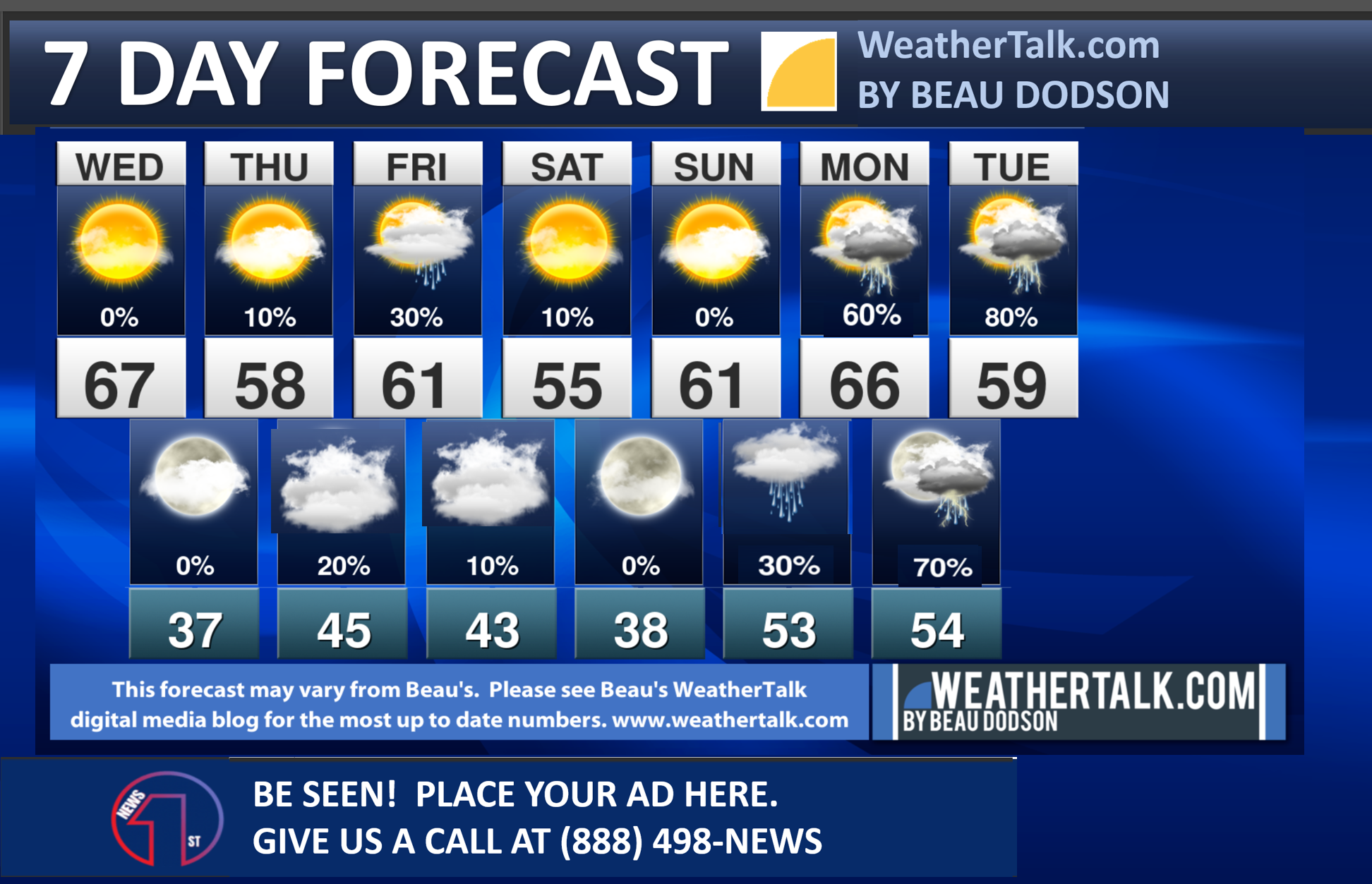
Seven-day forecast for southeast Missouri, southern Illinois, western Kentucky, and western Tennessee.
This is a BLEND for the region. Scroll down to see the region by region forecast.
48-hour forecast Graphics


.
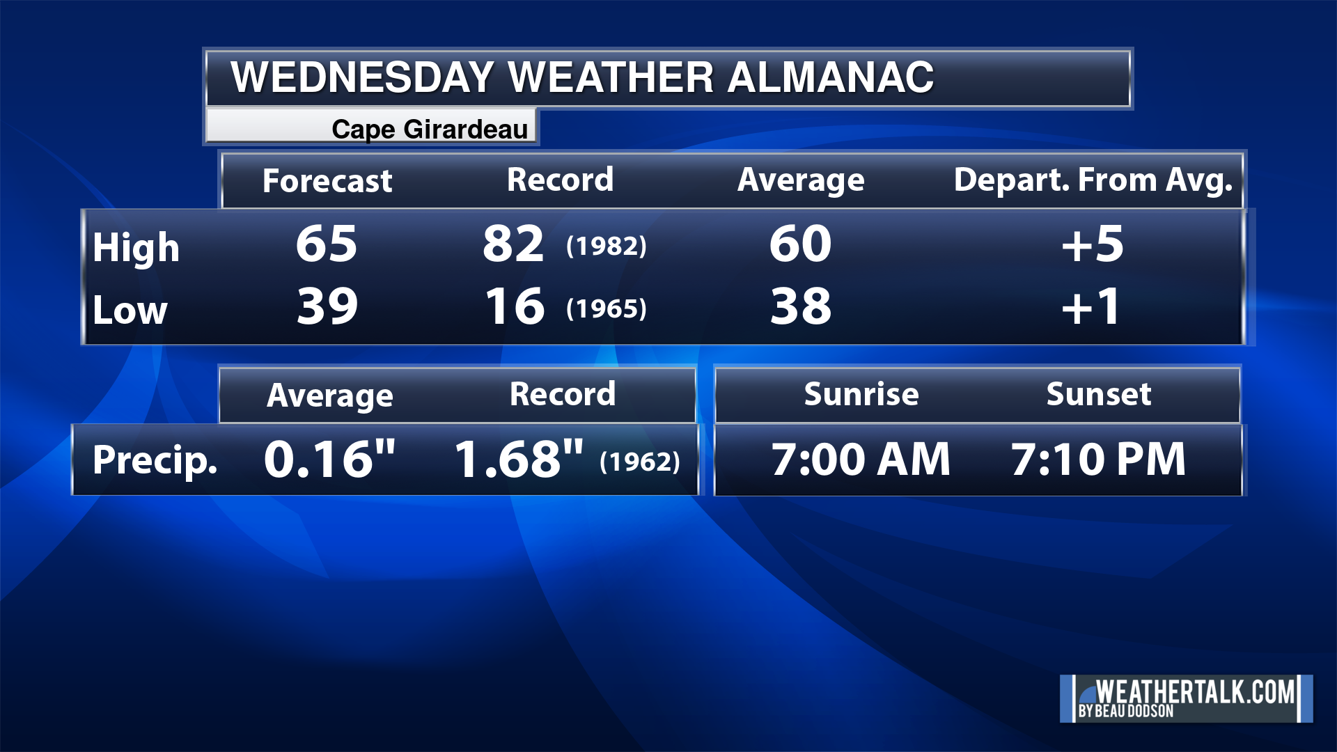
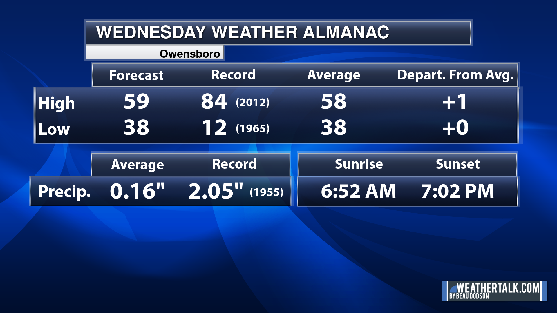
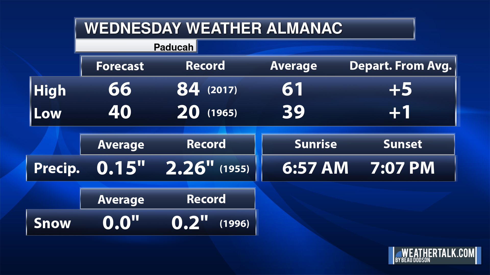
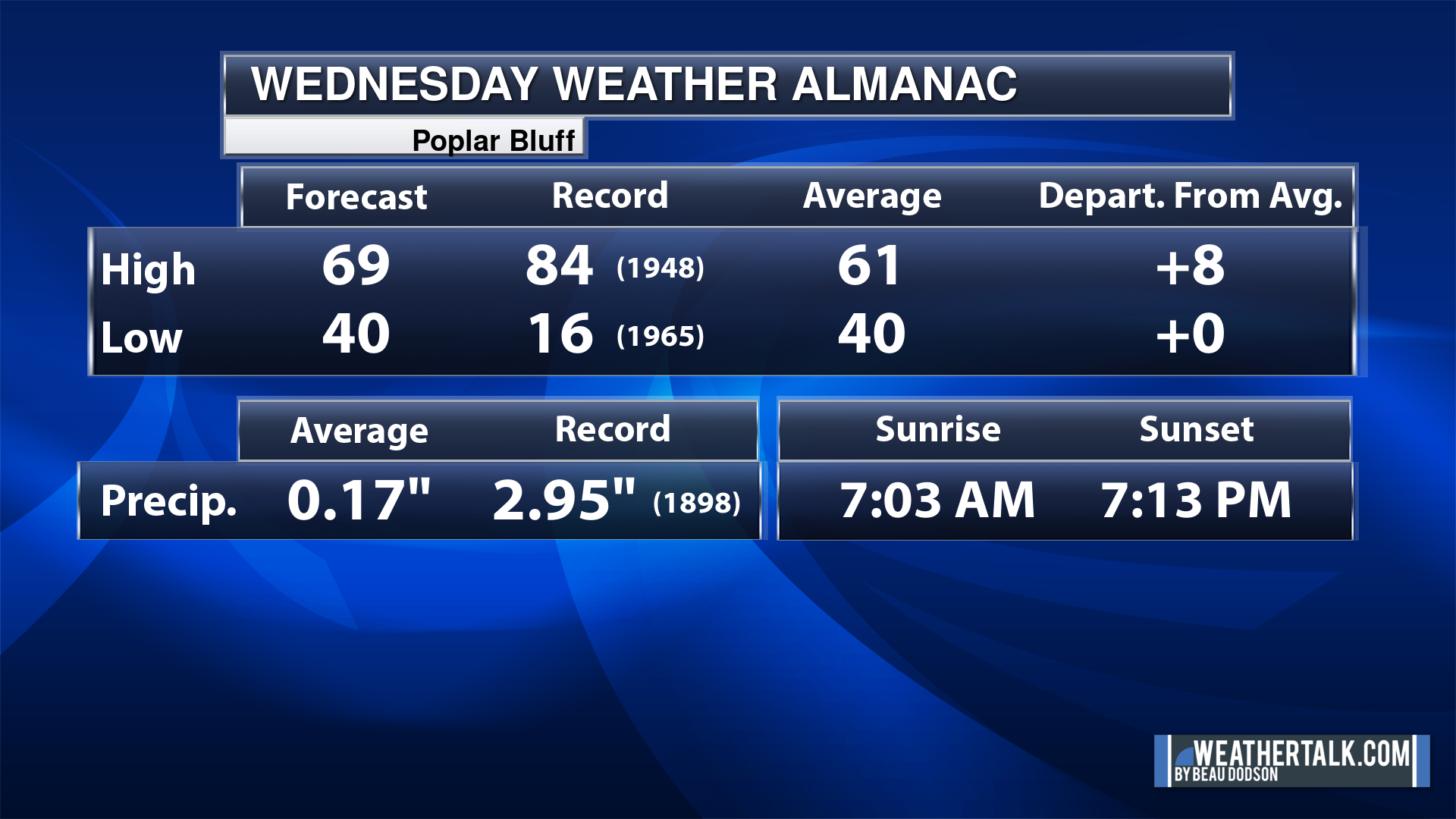
Today’s Local Almanacs (for a few select cities). Your location will be comparable.
Note, the low is this morning’s low and not tomorrows.
The forecast temperature shows you today’s expected high and this morning’s low.
The graphic shows you the record high and record low for today. It shows you what year that occurred, as well.
It then shows you what today’s average temperature is.
It shows you the departures (how may degrees above or below average temperatures will be ).
It shows you the average precipitation for today. Average comes from thirty years of rain totals.
It also shows you the record rainfall for the date and what year that occurred.
The sunrise and sunset are also shown.

![]()
.
.
Wednesday Forecast: Mostly sunny. A few afternoon clouds.
What is the chance of precipitation?
Far northern southeast Missouri ~ 0%
Southeast Missouri ~ 0%
The Missouri Bootheel ~ 0%
I-64 Corridor of southern Illinois ~ 0%
Southern Illinois ~ 0%
Extreme southern Illinois (southern seven counties) ~ 0%
Far western Kentucky (Purchase area) ~ 0%
The Pennyrile area of western KY ~ 0%
Northwest Kentucky (near Indiana border) ~ 0%
Northwest Tennessee ~ 0%
Coverage of precipitation:
Timing of the precipitation:
Far northern southeast Missouri ~ 60° to 64°
Southeast Missouri ~ 60° to 64°
The Missouri Bootheel ~ 65° to 70°
I-64 Corridor of southern Illinois ~ 56° to 58°
Southern Illinois ~ 60° to 64°
Extreme southern Illinois (southern seven counties) ~ 60° to 64°
Far western Kentucky ~ 64° to 66°
The Pennyrile area of western KY ~ 64° to 66°
Northwest Kentucky (near Indiana border) ~ 58° to 62°
Northwest Tennessee ~ 66° to 70°
Winds will be from this direction: North northeast 8 to 16 mph
Wind chill or heat index (feels like) temperature forecast: 52° to 62°
What impacts are anticipated from the weather?
Should I cancel my outdoor plans? No
UV Index: 6. High.
Sunrise: 6:58 AM
Sunset: 7:08 PM
.
Wednesday Night Forecast: A few clouds. Patchy frost and freeze conditions.
What is the chance of precipitation?
Far northern southeast Missouri ~ 0%
Southeast Missouri ~ 0%
The Missouri Bootheel ~ 0%
I-64 Corridor of southern Illinois ~ 0%
Southern Illinois ~ 0%
Extreme southern Illinois (southern seven counties) ~ 0%
Far western Kentucky (Purchase area) ~ 0%
The Pennyrile area of western KY ~ 0%
Northwest Kentucky (near Indiana border) ~ 0%
Northwest Tennessee ~ 0%
Coverage of precipitation:
Timing of the precipitation:
Temperature range:
Far northern southeast Missouri ~ 33° to 38°
Southeast Missouri ~ 34° to 38°
The Missouri Bootheel ~ 38° to 40°
I-64 Corridor of southern Illinois ~ 28° to 30°
Southern Illinois ~ 34° to 38°
Extreme southern Illinois (southern seven counties) ~ 38° to 40°
Far western Kentucky ~ 36° to 40°
The Pennyrile area of western KY ~ 36° to 38°
Northwest Kentucky (near Indiana border) ~ 36° to 38°
Northwest Tennessee ~ 38° to 40°
Winds will be from this direction: Northeast 7 to 14 mph
Wind chill or heat index (feels like) temperature forecast: 26° to 38°
What impacts are anticipated from the weather?
Should I cancel my outdoor plans? No
Moonrise: 2:55 PM
Moonset: 5:01 AM
The phase of the moon: Waxing Gibbous
.
Thursday Forecast: Intervals of clouds. A slight chance of showers.
What is the chance of precipitation?
Far northern southeast Missouri ~ 10%
Southeast Missouri ~ 20%
The Missouri Bootheel ~ 20%
I-64 Corridor of southern Illinois ~ 10%
Southern Illinois ~ 20%
Extreme southern Illinois (southern seven counties) ~ 20%
Far western Kentucky (Purchase area) ~ 20%
The Pennyrile area of western KY ~ 10%
Northwest Kentucky (near Indiana border) ~ 10%
Northwest Tennessee ~ 20%
Coverage of precipitation: Isolated light
Timing of the precipitation: Any given point of time
Far northern southeast Missouri ~ 50° to 52°
Southeast Missouri ~ 52° to 55°
The Missouri Bootheel ~ 56° to 60°
I-64 Corridor of southern Illinois ~ 50° to 52°
Southern Illinois ~ 53° to 56°
Extreme southern Illinois (southern seven counties) ~ 53° to 56°
Far western Kentucky ~ 58° to 60°
The Pennyrile area of western KY ~ 58° to 60°
Northwest Kentucky (near Indiana border) ~ 56° to 60°
Northwest Tennessee ~ 62° to 65°
Winds will be from this direction: Southeast 8 to 16 mph
Wind chill or heat index (feels like) temperature forecast: 50° to 60°
What impacts are anticipated from the weather? Isolated wet roadways.
Should I cancel my outdoor plans? No, but check the Beau Dodson Weather Radars
UV Index: 6. High.
Sunrise: 6:57 AM
Sunset: 7:08 PM
.
Thursday Night Forecast: Intervals of clouds. A slight chance of showers.
What is the chance of precipitation?
Far northern southeast Missouri ~ 10%
Southeast Missouri ~ 20%
The Missouri Bootheel ~ 20%
I-64 Corridor of southern Illinois ~ 10%
Southern Illinois ~ 20%
Extreme southern Illinois (southern seven counties) ~ 20%
Far western Kentucky (Purchase area) ~ 30%
The Pennyrile area of western KY ~ 30%
Northwest Kentucky (near Indiana border) ~ 20%
Northwest Tennessee ~ 30%
Coverage of precipitation: Widely scattered
Timing of the precipitation: Any given point of time
Temperature range:
Far northern southeast Missouri ~ 34° to 38°
Southeast Missouri ~ 43° to 46°
The Missouri Bootheel ~ 48° to 50°
I-64 Corridor of southern Illinois ~ 33° to 36°
Southern Illinois ~ 40° to 42°
Extreme southern Illinois (southern seven counties) ~ 40° to 45°
Far western Kentucky ~ 43° to 46°
The Pennyrile area of western KY ~ 44° to 46°
Northwest Kentucky (near Indiana border) ~ 40° to 44°
Northwest Tennessee ~ 46° to 48°
Winds will be from this direction: East 6 to 12 mph
Wind chill or heat index (feels like) temperature forecast: 30° to 46°
What impacts are anticipated from the weather? Wet roadways.
Should I cancel my outdoor plans? No, but monitor the Beau Dodson Weather Radars
Moonrise: 3:56 PM
Moonset: 5:31 AM
The phase of the moon: Waxing Gibbous
.
Friday Forecast: A mix of sun and clouds. A chance of showers over mainly our southern counties and southeastern counties (KY TN). Lower chances as you travel north.
What is the chance of precipitation?
Far northern southeast Missouri ~ 10%
Southeast Missouri ~ 20%
The Missouri Bootheel ~ 30%
I-64 Corridor of southern Illinois ~ 10%
Southern Illinois ~ 20%
Extreme southern Illinois (southern seven counties) ~ 20%
Far western Kentucky (Purchase area) ~ 30%
The Pennyrile area of western KY ~ 40%
Northwest Kentucky (near Indiana border) ~ 20%
Northwest Tennessee ~ 40%
Coverage of precipitation: Scattered
Timing of the precipitation: Any given point of time
Far northern southeast Missouri ~ 62° to 65°
Southeast Missouri ~ 62° to 65°
The Missouri Bootheel ~ 60° to 64°
I-64 Corridor of southern Illinois ~ 62° to 65°
Southern Illinois ~ 64° to 66°
Extreme southern Illinois (southern seven counties) ~ 62° to 64°
Far western Kentucky ~ 62° to 65°
The Pennyrile area of western KY ~ 62° to 65°
Northwest Kentucky (near Indiana border) ~ 62° to 65°
Northwest Tennessee ~ 62° to 65°
Winds will be from this direction: East southeast 6 to 12 mph
Wind chill or heat index (feels like) temperature forecast: 58° to 62°
What impacts are anticipated from the weather? Wet roadways.
Should I cancel my outdoor plans? No, but check the Beau Dodson Weather Radars
UV Index: 3. Moderate.
Sunrise: 6:55 AM
Sunset: 7:09 PM
.
Friday Night Forecast: Intervals of clouds. A slight chance of showers.
What is the chance of precipitation?
Far northern southeast Missouri ~ 10%
Southeast Missouri ~ 10%
The Missouri Bootheel ~ 10%
I-64 Corridor of southern Illinois ~ 10%
Southern Illinois ~ 10%
Extreme southern Illinois (southern seven counties) ~ 10%
Far western Kentucky (Purchase area) ~ 10%
The Pennyrile area of western KY ~ 20%
Northwest Kentucky (near Indiana border) ~ 10%
Northwest Tennessee ~ 20%
Coverage of precipitation: Isolated
Timing of the precipitation: Before midnight
Temperature range:
Far northern southeast Missouri ~ 34° to 38°
Southeast Missouri ~ 38° to 42°
The Missouri Bootheel ~ 40° to 44°
I-64 Corridor of southern Illinois ~ 34° to 38°
Southern Illinois ~ 38° to 42°
Extreme southern Illinois (southern seven counties) ~ 40° to 42°
Far western Kentucky ~ 42° to 44°
The Pennyrile area of western KY ~ 42° to 45°
Northwest Kentucky (near Indiana border) ~ 40° to 42°
Northwest Tennessee ~ 42° to 45°
Winds will be from this direction: North northwest 7 to 14 mph
Wind chill or heat index (feels like) temperature forecast: 32° to 42°
What impacts are anticipated from the weather? Isolated wet roadways.
Should I cancel my outdoor plans? No, but monitor the Beau Dodson Weather Radars
Moonrise: 4:55 PM
Moonset: 5:58 AM
The phase of the moon: Waxing Gibbous
.
Saturday Forecast: Mostly sunny.
What is the chance of precipitation?
Far northern southeast Missouri ~ 0%
Southeast Missouri ~ 0%
The Missouri Bootheel ~ 0%
I-64 Corridor of southern Illinois ~ 0%
Southern Illinois ~ 0%
Extreme southern Illinois (southern seven counties) ~ 0%
Far western Kentucky (Purchase area) ~ 0%
The Pennyrile area of western KY ~ 0%
Northwest Kentucky (near Indiana border) ~ 0%
Northwest Tennessee ~ 0%
Coverage of precipitation:
Timing of the precipitation:
Far northern southeast Missouri ~ 54° to 56°
Southeast Missouri ~ 54° to 56°
The Missouri Bootheel ~ 58° to 62°
I-64 Corridor of southern Illinois ~ 54° to 56°
Southern Illinois ~ 54° to 56°
Extreme southern Illinois (southern seven counties) ~ 56° to 58°
Far western Kentucky ~ 58° to 60°
The Pennyrile area of western KY ~ 58° to 60°
Northwest Kentucky (near Indiana border) ~ 58° to 60°
Northwest Tennessee ~ 58° to 60°
Winds will be from this direction: North 8 to 16 mph
Wind chill or heat index (feels like) temperature forecast: 54° to 58°
What impacts are anticipated from the weather?
Should I cancel my outdoor plans? No
UV Index: 6. High.
Sunrise: 6:54 AM
Sunset: 7:10 PM
.
Saturday Night Forecast: Partly cloudy. Chilly.
What is the chance of precipitation?
Far northern southeast Missouri ~ 0%
Southeast Missouri ~ 0%
The Missouri Bootheel ~ 0%
I-64 Corridor of southern Illinois ~ 0%
Southern Illinois ~ 0%
Extreme southern Illinois (southern seven counties) ~ 0%
Far western Kentucky (Purchase area) ~ 0%
The Pennyrile area of western KY ~ 0%
Northwest Kentucky (near Indiana border) ~ 0%
Northwest Tennessee ~ 0%
Coverage of precipitation:
Timing of the precipitation:
Temperature range:
Far northern southeast Missouri ~ 32° to 34°
Southeast Missouri ~ 34° to 36°
The Missouri Bootheel ~ 36° to 38°
I-64 Corridor of southern Illinois ~ 30° to 32°
Southern Illinois ~ 34° to 38°
Extreme southern Illinois (southern seven counties) ~ 34° to 38°
Far western Kentucky ~ 34° to 38°
The Pennyrile area of western KY ~ 34° to 38°
Northwest Kentucky (near Indiana border) ~ 34° to 38°
Northwest Tennessee ~ 34° to 38°
Winds will be from this direction: East northeast 7 to 14 mph
Wind chill or heat index (feels like) temperature forecast: 30° to 38°
What impacts are anticipated from the weather?
Should I cancel my outdoor plans? No
Moonrise: 5:53 PM
Moonset: 6:21 AM
The phase of the moon: Waxing Gibbous
.
Sunday Forecast: Partly sunny. A chance of afternoon showers.
What is the chance of precipitation?
Far northern southeast Missouri ~ 20%
Southeast Missouri ~ 20%
The Missouri Bootheel ~ 10%
I-64 Corridor of southern Illinois ~ 20%
Southern Illinois ~ 10%
Extreme southern Illinois (southern seven counties) ~ 10%
Far western Kentucky (Purchase area) ~ 10%
The Pennyrile area of western KY ~ 10%
Northwest Kentucky (near Indiana border) ~ 10%
Northwest Tennessee ~ 10%
Coverage of precipitation: Widely scattered
Timing of the precipitation: After 4 PM.
Far northern southeast Missouri ~ 63° to 66°
Southeast Missouri ~ 63° to 66°
The Missouri Bootheel ~ 63° to 66°
I-64 Corridor of southern Illinois ~ 63° to 66°
Southern Illinois ~ 63° to 66°
Extreme southern Illinois (southern seven counties) ~ 63° to 66°
Far western Kentucky ~ 63° to 66°
The Pennyrile area of western KY ~ 63° to 66°
Northwest Kentucky (near Indiana border) ~ 63° to 66°
Northwest Tennessee ~ 63° to 66°
Winds will be from this direction: East southeast 10 to 20 mph. Gusty.
Wind chill or heat index (feels like) temperature forecast: 60° to 65°
What impacts are anticipated from the weather? Wet roadways.
Should I cancel my outdoor plans? No
UV Index: 3. Moderate.
Sunrise: 6:52 AM
Sunset: 7:11 PM
.
Sunday Night Forecast: Increasing clouds. A chance of showers and perhaps a thunderstorm.
What is the chance of precipitation?
Far northern southeast Missouri ~ 60%
Southeast Missouri ~ 60%
The Missouri Bootheel ~ 60%
I-64 Corridor of southern Illinois ~ 30%
Southern Illinois ~ 30%
Extreme southern Illinois (southern seven counties) ~ 30%
Far western Kentucky (Purchase area) ~ 30%
The Pennyrile area of western KY ~ 30%
Northwest Kentucky (near Indiana border) ~ 30%
Northwest Tennessee ~ 30%
Coverage of precipitation: Scattered
Timing of the precipitation: Any given point of time
Temperature range:
Far northern southeast Missouri ~ 50° to 55°
Southeast Missouri ~ 50° to 55°
The Missouri Bootheel ~ 50° to 55°
I-64 Corridor of southern Illinois ~ 50° to 55°
Southern Illinois ~ 50° to 55°
Extreme southern Illinois (southern seven counties) ~ 50° to 55°
Far western Kentucky ~ 50° to 55°
The Pennyrile area of western KY ~ 50° to 55°
Northwest Kentucky (near Indiana border) ~ 50° to 55°
Northwest Tennessee ~ 50° to 55°
Winds will be from this direction: South 10 to 30 mph. Gusty.
Wind chill or heat index (feels like) temperature forecast: 50° to 55°
What impacts are anticipated from the weather? Wet roadways. Lightning.
Should I cancel my outdoor plans? No, but monitor updates on rain probabilities and timing.
Moonrise: 6:51 PM
Moonset: 6:42 AM
The phase of the moon: Full
.
Monday Forecast: Mostly cloudy with showers and thunderstorms likely.
What is the chance of precipitation?
Far northern southeast Missouri ~ 80%
Southeast Missouri ~ 80%
The Missouri Bootheel ~ 80%
I-64 Corridor of southern Illinois ~ 70%
Southern Illinois ~ 70%
Extreme southern Illinois (southern seven counties) ~ 70%
Far western Kentucky (Purchase area) ~ 70%
The Pennyrile area of western KY ~ 70%
Northwest Kentucky (near Indiana border) ~ 70%
Northwest Tennessee ~ 70%
Coverage of precipitation: Widespread
Timing of the precipitation: Any given point of time
Far northern southeast Missouri ~ 64° to 66°
Southeast Missouri ~ 64° to 66°
The Missouri Bootheel ~ 64° to 68°
I-64 Corridor of southern Illinois ~ 63° to 66°
Southern Illinois ~ 64° to 66°
Extreme southern Illinois (southern seven counties) ~ 64° to 66°
Far western Kentucky ~ 64° to 68°
The Pennyrile area of western KY ~ 64° to 68°
Northwest Kentucky (near Indiana border) ~ 64° to 66°
Northwest Tennessee ~ 64° to 68°
Winds will be from this direction: South 15 to 30 mph. Gusty.
Wind chill or heat index (feels like) temperature forecast: 60° to 68°
What impacts are anticipated from the weather? Wet roadways. Lightning.
Should I cancel my outdoor plans? Have a plan B and monitor the Beau Dodson Weather Radars.
UV Index: 3. Moderate.
Sunrise: 6:51 AM
Sunset: 7:12 PM
.
Monday Night Forecast: Mostly cloudy. A chance of showers and thunderstorms.
What is the chance of precipitation?
Far northern southeast Missouri ~ 70%
Southeast Missouri ~ 70%
The Missouri Bootheel ~ 70%
I-64 Corridor of southern Illinois ~ 70%
Southern Illinois ~ 70%
Extreme southern Illinois (southern seven counties) ~ 70%
Far western Kentucky (Purchase area) ~ 70%
The Pennyrile area of western KY ~ 70%
Northwest Kentucky (near Indiana border) ~ 70%
Northwest Tennessee ~ 70%
Coverage of precipitation: Numerous
Timing of the precipitation: Any given point of time
Temperature range:
Far northern southeast Missouri ~ 42° to 44°
Southeast Missouri ~ 42° to 45°
The Missouri Bootheel ~ 43° to 46°
I-64 Corridor of southern Illinois ~ 40° to 44°
Southern Illinois ~ 42° to 44°
Extreme southern Illinois (southern seven counties) ~ 42° to 44°
Far western Kentucky ~ 42° to 45°
The Pennyrile area of western KY ~ 42° to 45°
Northwest Kentucky (near Indiana border) ~ 42° to 45°
Northwest Tennessee ~ 42° to 45°
Winds will be from this direction: Southwest becoming west 10 to 25 mph with higher gusts.
Wind chill or heat index (feels like) temperature forecast: 40° to 45°
What impacts are anticipated from the weather? Wet roadways. Lightning.
Should I cancel my outdoor plans? Have a plan B and monitor the Beau Dodson Weather Radars.
Moonrise: 7:48 PM
Moonset: 7:03 AM
The phase of the moon: Full
.
Click here if you would like to return to the top of the page.

-
- Chilly nights.
- Decent weather days today through Sunday morning.
- Low end shower chances Thursday/Friday (mainly south and east in TN/KY)
- A larger system Sunday into Tuesday of next week. I will need to fine tune the timing. It may end up being Monday and Tuesday for the primary cold front.
Weather advice:
Do you have any suggestions or comments? Email me at beaudodson@usawx.com
Make sure you have three to five ways of receiving your severe weather information.
.
Beau’s Forecast Discussion
Good morning, everyone.
Well, our hard freeze yesterday did quite a bit of damage. Many of you are reporting the blooms on your trees have turned black or wilted. I have noted numerous trees in extremes southern Illinois and western Kentucky that appeared to have not made it through the cold temps.
We aren’t finished with cold air. Several nights this week will dip into the 30s. That could mean frost, if winds subside. Even a light freeze for some counties. Check the daily forecast numbers for the low temperatures.
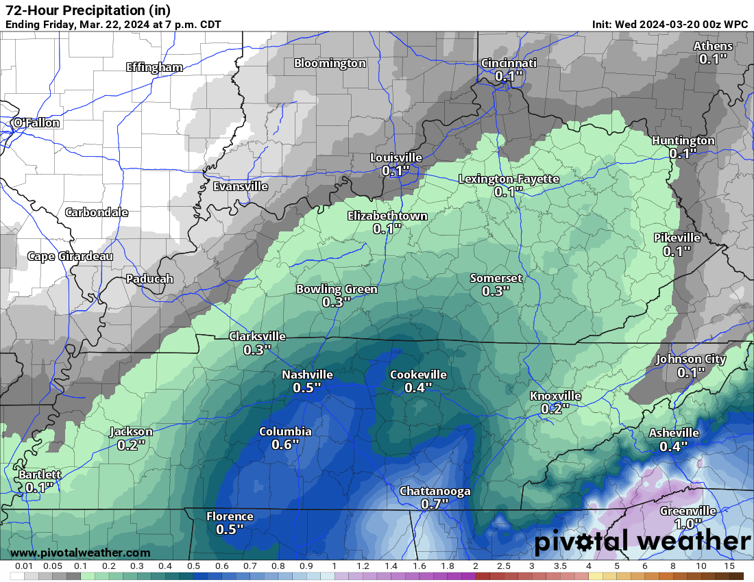
A weak southern storm system will bring a few light showers to the region Thursday PM into Friday. I continue to cap rain chances in the 20% to 30% range. Perhaps I will bump that up to 40% or so near Hopkinsville, Kentucky.
Those rain chances are mainly for areas in western Kentucky and western Tennessee.
The chance of showers will be lower as you travel north and west.
If it does rain, it will be light. Trace amounts to less than 0.15″. Again, the highest probability will those amounts will be over Tennessee and Kentucky.
Here is the official WPC NOAA rainfall forecast. A sharp cut-off in the totals from northwest to southeast.
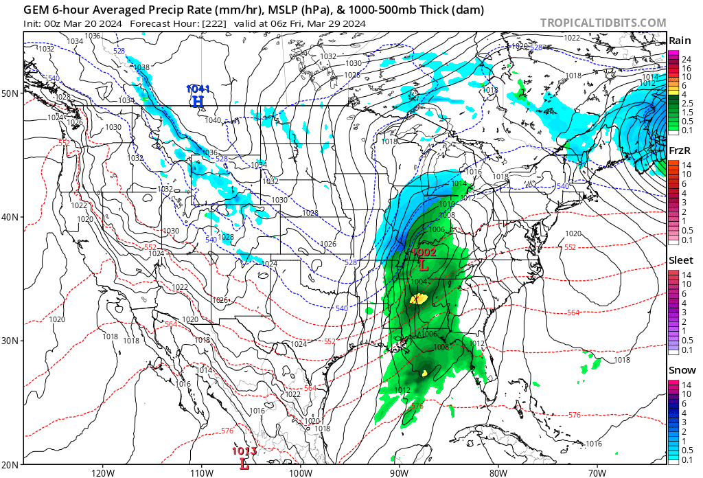
A larger system will push into the region late Sunday night into Tuesday. Peak rain chances will arrive Monday into Tuesday.
I have been fine tuning the rain probabilities and the timing.
The data is beginning to zero in on Monday/Monday night for the peak rainfall chances. Whether that continues into Tuesday, will need to be monitored. For now, I kept rain chances going into Tuesday.
This appears to be a widespread one inch rain event, with pockets of higher totals possible.
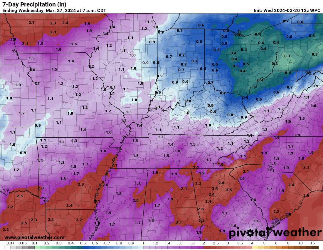
Some data shows a second system forming right behind the first one. That wave would keep rain going into at least Tuesday/Tuesday night. Perhaps even Wednesday.
Confidence on the second low is low. I will monitor trends.
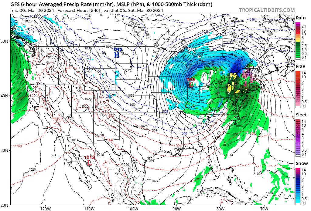
Severe thunderstorms?
At this time, moisture return appears meager. Dew points look to remain in the 50s. If that is the case, then the risk of severe weather would be zero or limited.
If dew points end up being a bit higher, then severe storms will be possible. For now, no risk outline has been issued for this event. I don’t think we will have a better handle on that until Thursday night and Friday. By then, we should know a bit more.
I am hoping we don’t have to deal with severe weather. I have a severe weather conference Friday through Sunday in Mississippi! So, I would rather not deal with severe weather Monday and Tuesday! But, we will take what we get.
I will monitor trends. For now, I am not worried about severe weather Monday or Tuesday. Monitor updates moving forward in case we have adjustments.
No extreme temperatures through Wednesday.
We will have gusty winds Sunday into Tuesday. Occasional gusts above 30 mph will be possible. A deep area of low pressure will move to our north and west Monday/Tuesday. That will tighter the barometric pressure gradient and kick up our winds.
Models show another system around next Thursday or Friday.
Long way off for the models to know how that one will transpire. I will keep an eye on it.
GFS model
Canadian Model
![]()
.
Click here if you would like to return to the top of the page.
This outlook covers southeast Missouri, southern Illinois, western Kentucky, and far northwest Tennessee.

.
Today’s Storm Prediction Center’s (SPC) Severe Weather Outlook
Light green is where thunderstorms may occur but should be below severe levels.
Dark green is a level one risk. Yellow is a level two risk. Orange is a level three (enhanced) risk. Red is a level four (moderate) risk. Pink is a level five (high) risk.
One is the lowest risk. Five is the highest risk.
A severe storm is one that produces 58 mph wind or higher, quarter or larger size hail, and/or a tornado.
Explanation of tables. Click here.
Day One Severe Weather Outlook

Day One Severe Weather Outlook. Zoomed in on our region.

.
Day One Tornado Probability Outlook

Day One Regional Tornado Outlook. Zoomed in on our region.

.
Day One Large Hail Probability Outlook

Day One Regional Hail Outlook. Zoomed in on our region.

.
Day One High wind Probability Outlook

Day One Regional Wind Outlook. Zoomed in on our region.

.
Tomorrow’s severe weather outlook. Day two outlook.

Day Two Outlook. Zoomed in on our region.

.
Day Three Severe Weather Outlook

.

.
The images below are from NOAA’s Weather Prediction Center.
24-hour precipitation outlook..
 .
.
.
48-hour precipitation outlook.
. .
.
![]()
_______________________________________
.

Click here if you would like to return to the top of the page.
Again, as a reminder, these are models. They are never 100% accurate. Take the general idea from them.
What should I take from these?
- The general idea and not specifics. Models usually do well with the generalities.
- The time-stamp is located in the upper left corner.
.
What am I looking at?
You are looking at computer model data. Meteorologists use many different models to forecast the weather.
Occasionally, these maps are in Zulu time. 12z=7 AM. 18z=1 PM. 00z=7 PM. 06z=1 AM
Green represents light rain. Dark green represents moderate rain. Yellow and orange represent heavier rain.
.
This animation is the FVS Model.
Occasionally, these maps are in Zulu time. 12z=6 AM. 18z=12 PM. 00z=6 PM. 06z=12 AM
Double click images to enlarge them. Blue is snow. Pink is a wintry mix. Green is rain.
.
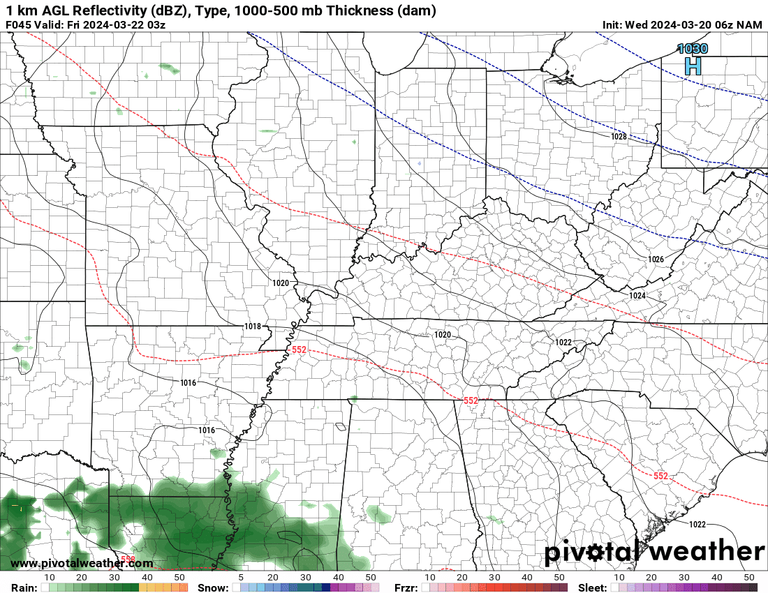
This animation is the NAM Model.
Occasionally, these maps are in Zulu time. 12z=6 AM. 18z=12 PM. 00z=6 PM. 06z=12 AM
Double click images to enlarge them.
.
This animation is the HRRR Model.
Green is rain. Yellow and orange are heavier rain. Pink is a wintry mix. Blue is snow. Dark blue is heavier snow.
Occasionally, these maps are in Zulu time. 12z=6 AM. 18z=12 PM. 00z=6 PM. 06z=12 AM
Double click images to enlarge them.
.
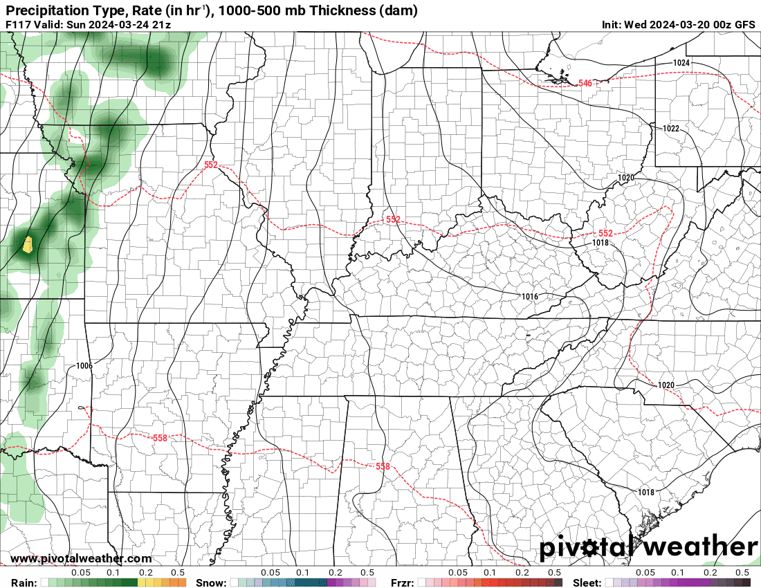
This animation is the GFS Model.
Green is rain. Yellow and orange are heavier rain. Pink is a wintry mix. Blue is snow. Dark blue is heavier snow.
Occasionally, these maps are in Zulu time. 12z=6 AM. 18z=12 PM. 00z=6 PM. 06z=12 AM
Double click images to enlarge them.
.
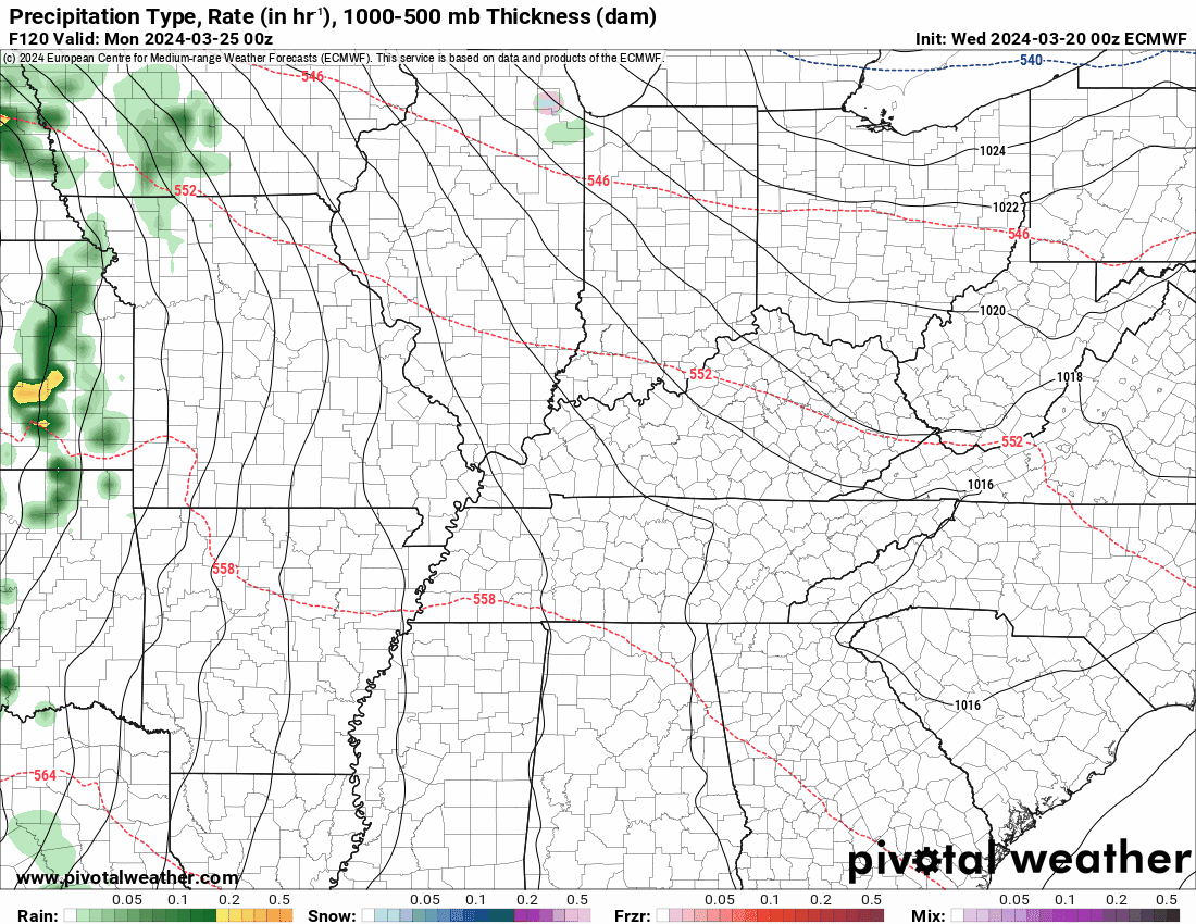
This animation is the EC Model.
Green is rain. Yellow and orange are heavier rain. Pink is a wintry mix. Blue is snow. Dark blue is heavier snow.
Occasionally, these maps are in Zulu time. 12z=6 AM. 18z=12 PM. 00z=6 PM. 06z=12 AM
Double click images to enlarge them.
..![]()

.
Click here if you would like to return to the top of the page.
.Average high temperatures for this time of the year are around 56 degrees.
Average low temperatures for this time of the year are around 36 degrees.
Average precipitation during this time period ranges from 0.60″ to 1.20″
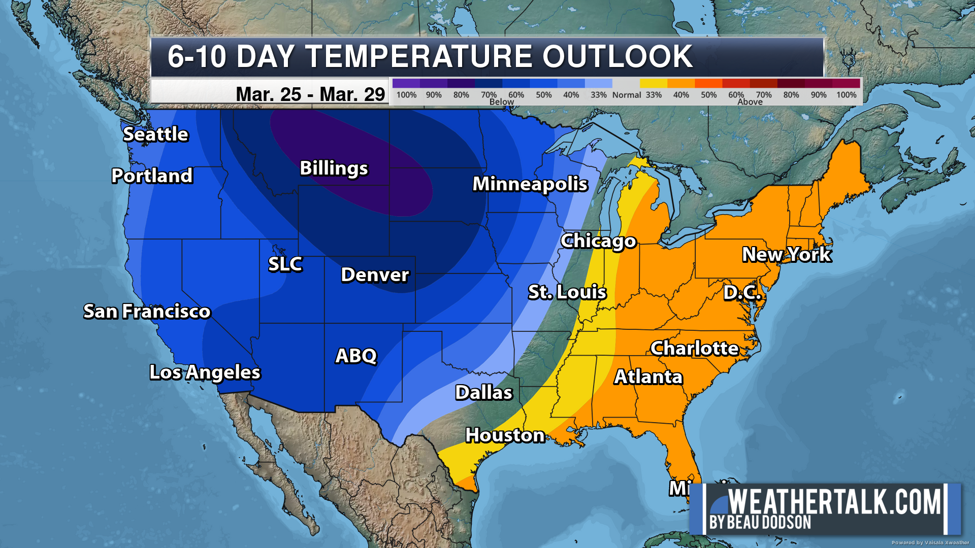
Six to Ten Day Outlook.
Blue is below average. Red is above average. The no color zone represents equal chances.
Average highs for this time of the year are in the lower 60s. Average lows for this time of the year are in the lower 40s.
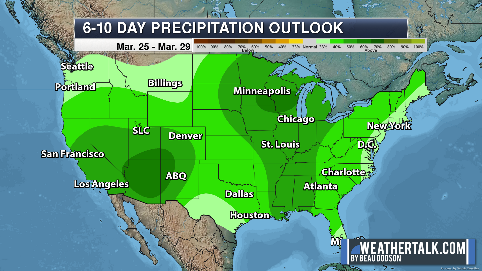
Green is above average precipitation. Yellow and brown favors below average precipitation. Average precipitation for this time of the year is around one inch per week.
.

Average low temperatures for this time of the year are around 38 degrees.
Average precipitation during this time period ranges from 0.60″ to 1.20″
.
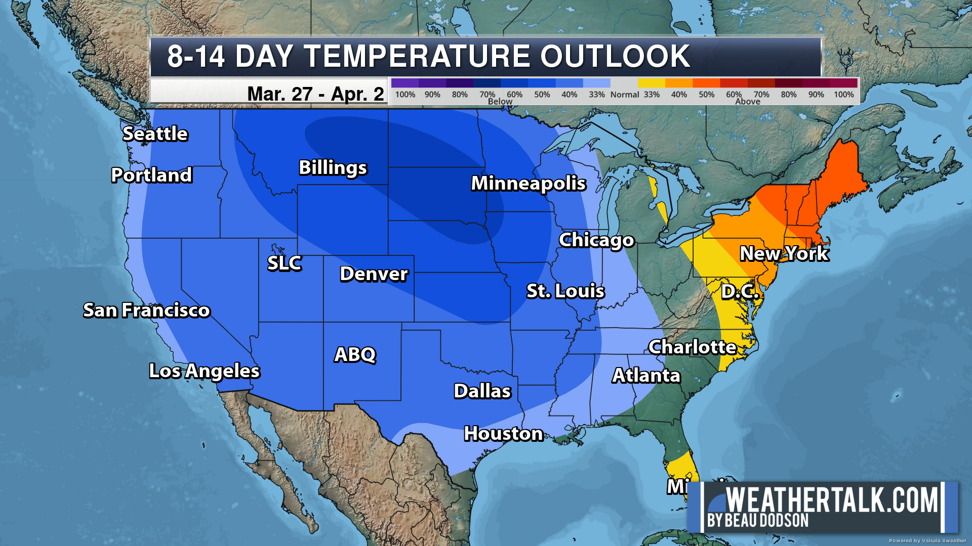
Eight to Fourteen Day Outlook.
Blue is below average. Red is above average. The no color zone represents equal chances.
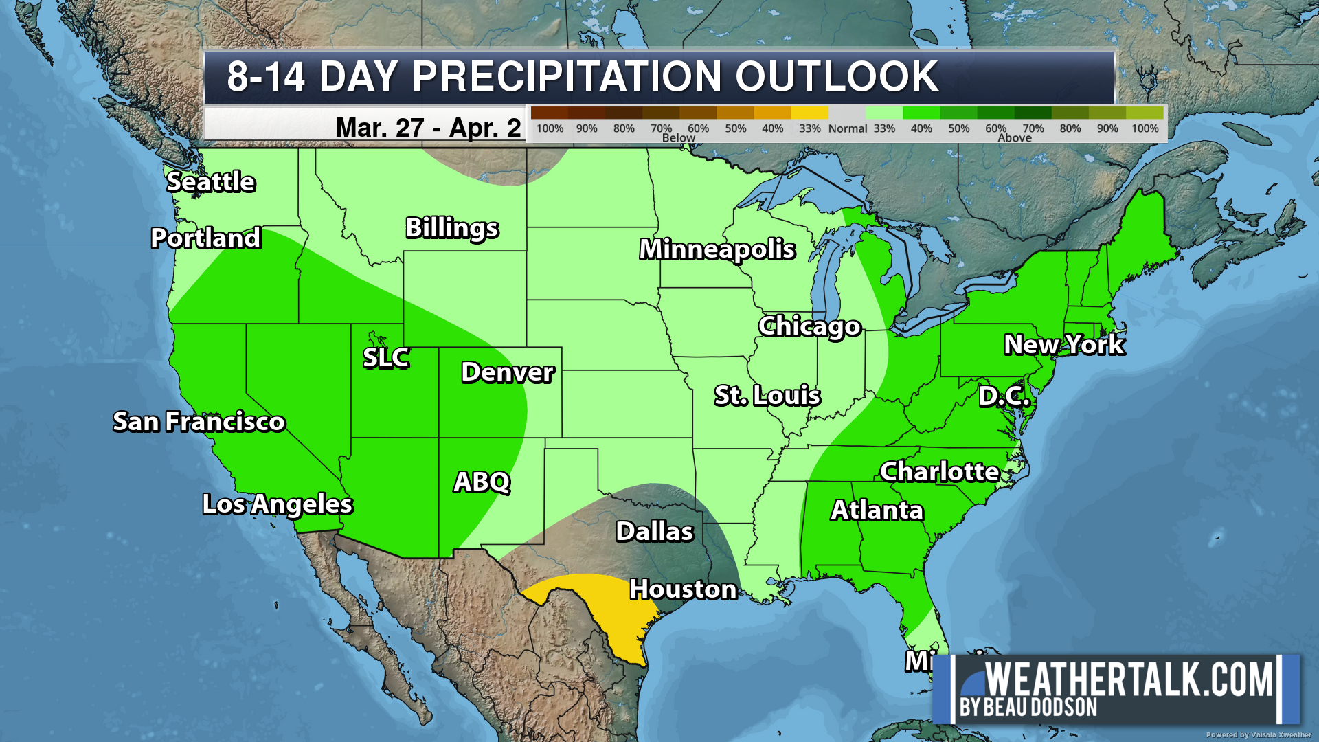
Green is above average precipitation. Yellow and brown favors below average precipitation. Average precipitation for this time of the year is around one inch per week.
.
![]()
The app is for subscribers. Subscribe at www.weathertalk.com/welcome then go to your app store and search for WeatherTalk
Subscribers, PLEASE USE THE APP. ATT and Verizon are not reliable during severe weather. They are delaying text messages.
The app is under WeatherTalk in the app store.

Apple users click here

Android users click here
.

Radars and Lightning Data
Interactive-city-view radars. Clickable watches and warnings.
https://wtalk.co/B3XHASFZ
If the radar is not updating then try another one. If a radar does not appear to be refreshing then hit Ctrl F5. You may also try restarting your browser.
Backup radar site in case the above one is not working.
https://weathertalk.com/morani
Regional Radar
https://imagery.weathertalk.com/prx/RadarLoop.mp4
** NEW ** Zoom radar with chaser tracking abilities!
ZoomRadar
Lightning Data (zoom in and out of your local area)
https://wtalk.co/WJ3SN5UZ
Not working? Email me at beaudodson@usawx.com
National map of weather watches and warnings. Click here.
Storm Prediction Center. Click here.
Weather Prediction Center. Click here.
.

Live lightning data: Click here.
Real time lightning data (another one) https://map.blitzortung.org/#5.02/37.95/-86.99
Our new Zoom radar with storm chases
.
.

Interactive GOES R satellite. Track clouds. Click here.
GOES 16 slider tool. Click here.
College of DuPage satellites. Click here
.

Here are the latest local river stage forecast numbers Click Here.
Here are the latest lake stage forecast numbers for Kentucky Lake and Lake Barkley Click Here.
.
.
Find Beau on Facebook! Click the banner.


 .
.