
Click one of the links below to take you directly to that section
![]()
![]()
![]()
![]()
![]()
![]()
![]()
.

.
Seven Day Hazardous Weather Outlook
1. Is lightning in the forecast? YES. Lightning is possible next Sunday night into Monday night. I will monitor Tuesday into Thursday.
2. Are severe thunderstorms in the forecast? MONITOR. I am monitoring early next week.
3. Is flash flooding in the forecast? MONITOR. I am monitoring early next week.
4. Will non-thunderstorm winds top 40 mph? MONITOR. I am monitoring early next week.
5. Will the heat index exceed 100 degrees? NO.
6. Will the wind chill dip below 10 degrees? NO.
7. Is measurable snow and/or sleet in the forecast? NO.
8. Is freezing rain/ice in the forecast? NO.
Freezing rain is rain that falls and instantly freezes on objects such as trees and power lines Freezing fog possible, as well.
.

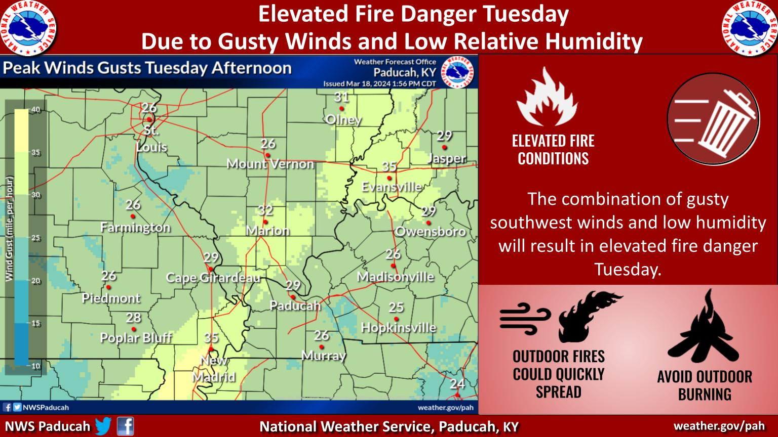
Fire weather risk level.
Tuesday through Tuesday night: 5. Medium risk.
Wednesday: 5. Medium risk.
Wednesday night: 4. Low risk.
Fire Weather Discussion
Continued very dry conditions, along with gusty southwesterly winds midday through the afternoon today, will result in elevated fire weather danger. Sustained winds increase to 15 to 20 mph today with gusts of around 30 mph midday through the afternoon. Gusts slowly decrease in the evening hours. RHs today drop to 20 to 25 percent across much of the Quad State. A few sites may briefly fall below 20 percent. Following a dry frontal passage, dry conditions remain tomorrow with RHs around 25 to 30 percent and winds shifted to northerly. A few showers are possible Thursday in the south and Friday in the north and east, but rainfall amounts will be light. A much rainier system is expected for the start of next week.
A Haines Index of 6 means a high potential for an existing fire to become large or exhibit erratic fire behavior, 5 means medium potential, 4 means low potential, and anything less than 4 means very low potential.
Seven-day forecast for southeast Missouri, southern Illinois, western Kentucky, and western Tennessee.
This is a BLEND for the region. Scroll down to see the region by region forecast.
.

THE FORECAST IS GOING TO VARY FROM LOCATION TO LOCATION.
Scroll down to see your local forecast details.
48-hour forecast Graphics


.
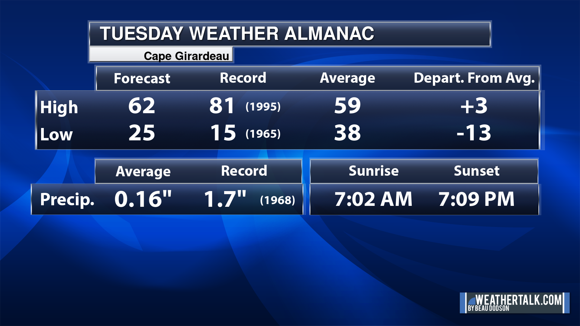
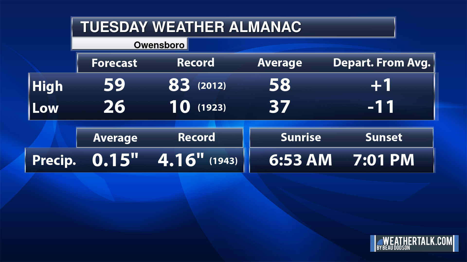
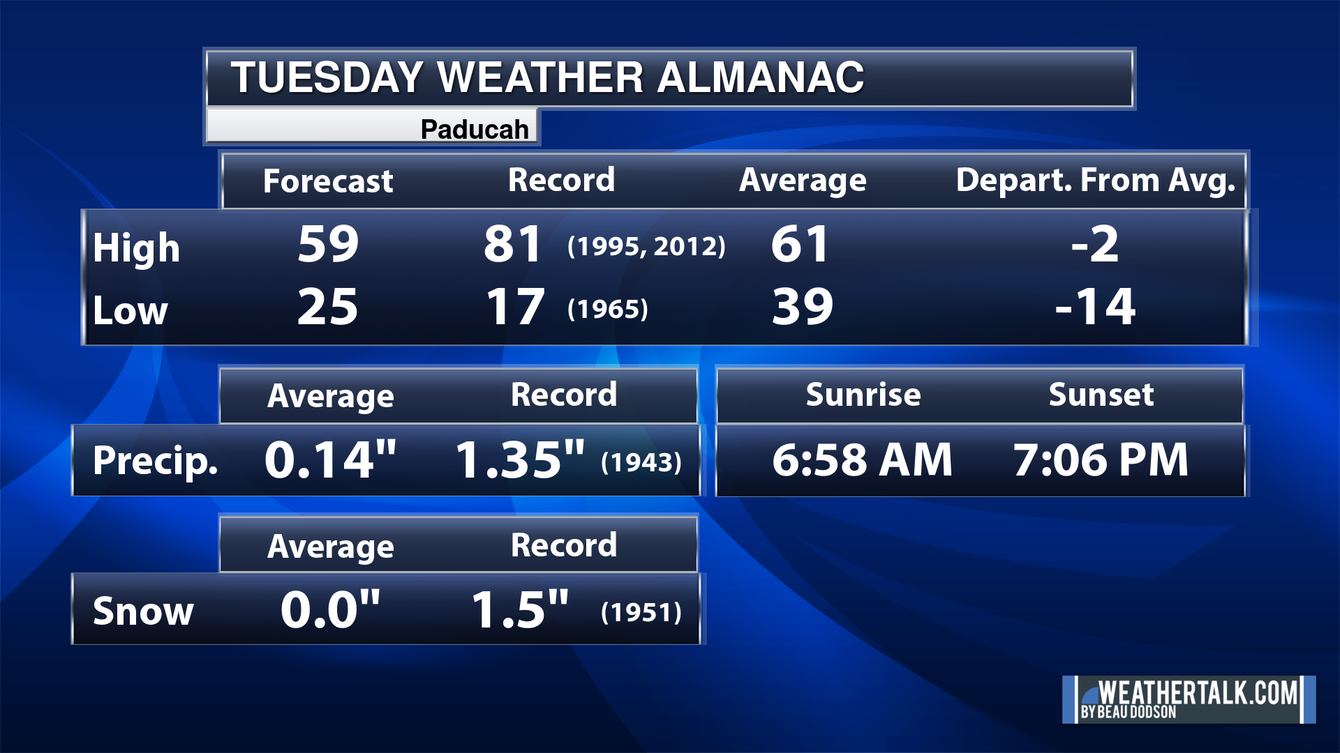
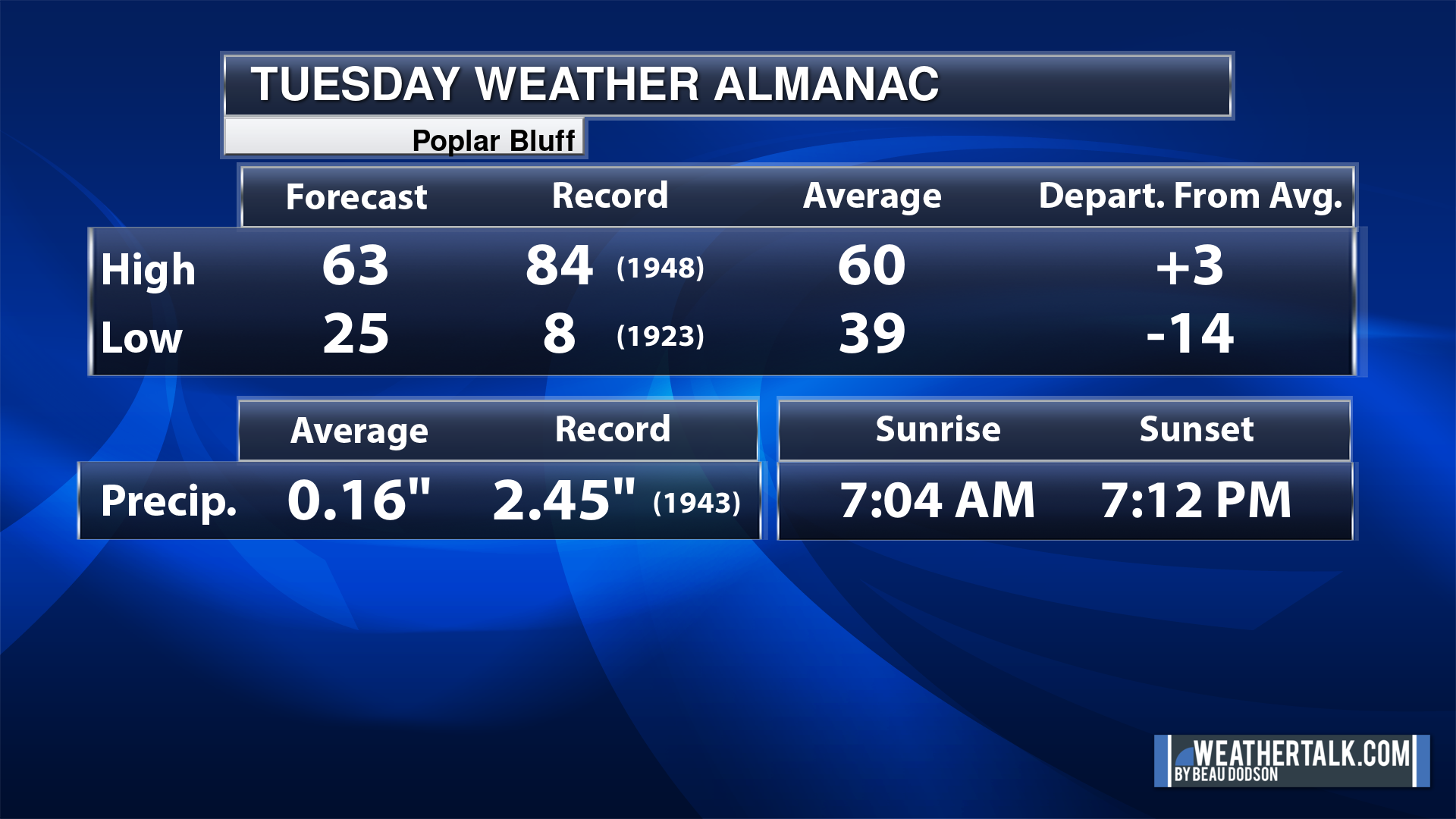
Today’s Local Almanacs (for a few select cities). Your location will be comparable.
Note, the low is this morning’s low and not tomorrows.
The forecast temperature shows you today’s expected high and this morning’s low.
The graphic shows you the record high and record low for today. It shows you what year that occurred, as well.
It then shows you what today’s average temperature is.
It shows you the departures (how may degrees above or below average temperatures will be ).
It shows you the average precipitation for today. Average comes from thirty years of rain totals.
It also shows you the record rainfall for the date and what year that occurred.
The sunrise and sunset are also shown.

![]()
.
.
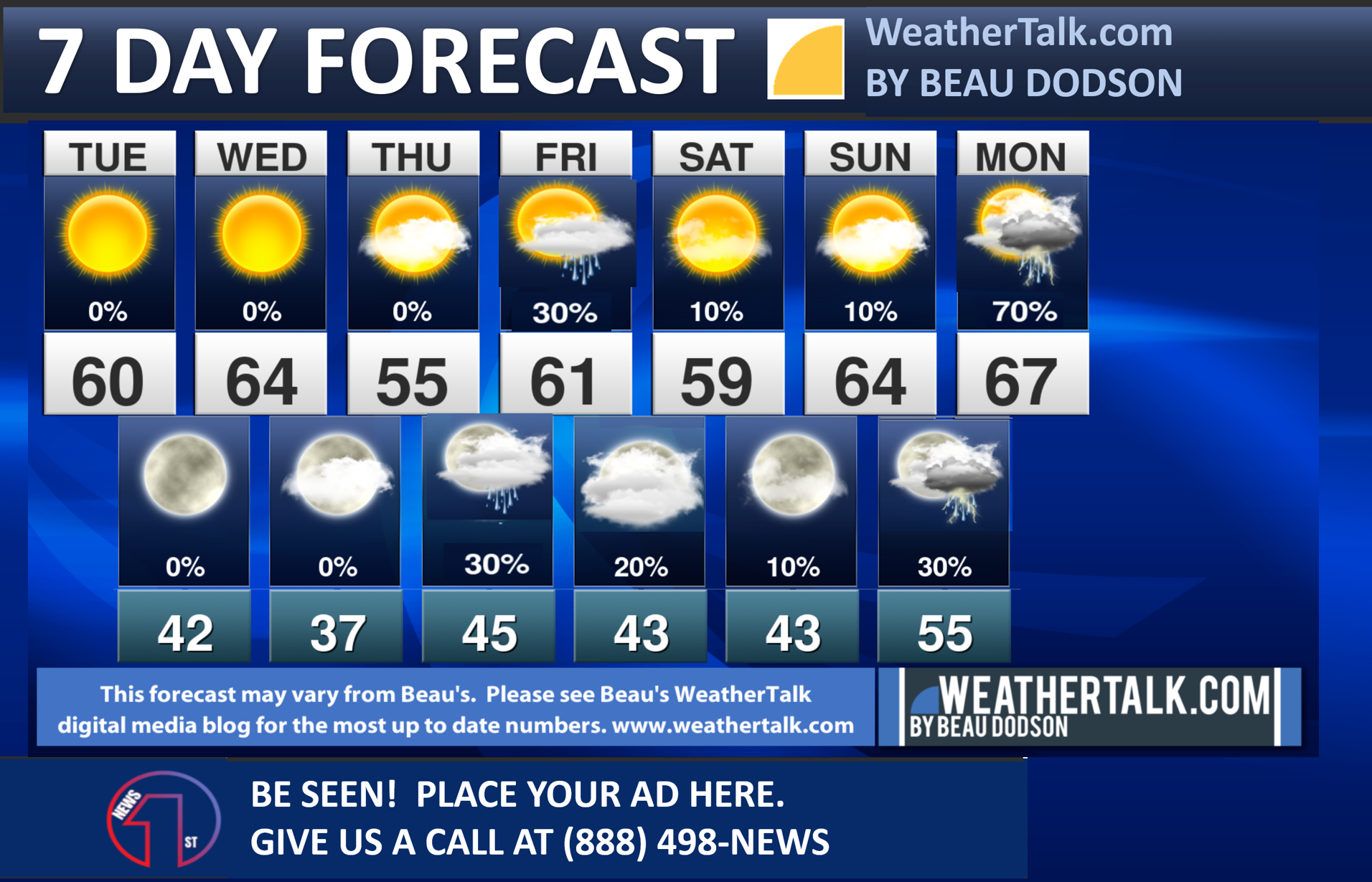
Tuesday Forecast: Mostly sunny. Windy. A hard freeze during the morning.
What is the chance of precipitation?
Far northern southeast Missouri ~ 0%
Southeast Missouri ~ 0%
The Missouri Bootheel ~ 0%
I-64 Corridor of southern Illinois ~ 0%
Southern Illinois ~ 0%
Extreme southern Illinois (southern seven counties) ~ 0%
Far western Kentucky (Purchase area) ~ 0%
The Pennyrile area of western KY ~ 0%
Northwest Kentucky (near Indiana border) ~ 0%
Northwest Tennessee ~ 0%
Coverage of precipitation:
Timing of the precipitation:
Far northern southeast Missouri ~ 66° to 68°
Southeast Missouri ~ 64° to 66°
The Missouri Bootheel ~ 60° to 62°
I-64 Corridor of southern Illinois ~ 58° to 62°
Southern Illinois ~ 58° to 62°
Extreme southern Illinois (southern seven counties) ~ 58° to 62°
Far western Kentucky ~ 58° to 62°
The Pennyrile area of western KY ~ 54° to 56°
Northwest Kentucky (near Indiana border) ~ 55° to 60°
Northwest Tennessee ~ 58° to 62°
Winds will be from this direction: Southwest 10 to 35 mph. Gusty.
Wind chill or heat index (feels like) temperature forecast: 45° to 55°
What impacts are anticipated from the weather?
Should I cancel my outdoor plans? No
UV Index: 6. High.
Sunrise: 6:59 AM
Sunset: 7:07 PM
.
Tuesday Night Forecast: Mostly clear. Patchy frost.
What is the chance of precipitation?
Far northern southeast Missouri ~ 0%
Southeast Missouri ~ 0%
The Missouri Bootheel ~ 0%
I-64 Corridor of southern Illinois ~ 0%
Southern Illinois ~ 0%
Extreme southern Illinois (southern seven counties) ~ 0%
Far western Kentucky (Purchase area) ~ 0%
The Pennyrile area of western KY ~ 0%
Northwest Kentucky (near Indiana border) ~ 0%
Northwest Tennessee ~ 0%
Coverage of precipitation:
Timing of the precipitation:
Temperature range:
Far northern southeast Missouri ~ 34° to 38°
Southeast Missouri ~ 35° to 40°
The Missouri Bootheel ~ 36° to 40°
I-64 Corridor of southern Illinois ~ 34° to 38°
Southern Illinois ~ 36° to 40°
Extreme southern Illinois (southern seven counties) ~ 38° to 40°
Far western Kentucky ~ 38° to 40°
The Pennyrile area of western KY ~ 38° to 42°
Northwest Kentucky (near Indiana border) ~ 36° to 40°
Northwest Tennessee ~ 38° to 42°
Winds will be from this direction: West southwest 10 to 20 mph
Wind chill or heat index (feels like) temperature forecast: 30° to 40°
What impacts are anticipated from the weather?
Should I cancel my outdoor plans? No
Moonrise: 1:53 PM
Moonset: 4:25 AM
The phase of the moon: Waxing Gibbous
.
Wednesday Forecast: Mostly sunny. A few afternoon clouds.
What is the chance of precipitation?
Far northern southeast Missouri ~ 0%
Southeast Missouri ~ 0%
The Missouri Bootheel ~ 0%
I-64 Corridor of southern Illinois ~ 0%
Southern Illinois ~ 0%
Extreme southern Illinois (southern seven counties) ~ 0%
Far western Kentucky (Purchase area) ~ 0%
The Pennyrile area of western KY ~ 0%
Northwest Kentucky (near Indiana border) ~ 0%
Northwest Tennessee ~ 0%
Coverage of precipitation:
Timing of the precipitation:
Far northern southeast Missouri ~ 62° to 64°
Southeast Missouri ~ 62° to 64°
The Missouri Bootheel ~ 65° to 70°
I-64 Corridor of southern Illinois ~ 56° to 58°
Southern Illinois ~ 60° to 64°
Extreme southern Illinois (southern seven counties) ~ 60° to 64°
Far western Kentucky ~ 63° to 66°
The Pennyrile area of western KY ~ 62° to 65°
Northwest Kentucky (near Indiana border) ~ 58° to 62°
Northwest Tennessee ~ 64° to 68°
Winds will be from this direction: North northeast 8 to 16 mph
Wind chill or heat index (feels like) temperature forecast: 52° to 62°
What impacts are anticipated from the weather?
Should I cancel my outdoor plans? No
UV Index: 6. High.
Sunrise: 6:58 AM
Sunset: 7:08 PM
.
Wednesday Night Forecast: A few clouds. Patchy frost and freeze conditions.
What is the chance of precipitation?
Far northern southeast Missouri ~ 0%
Southeast Missouri ~ 0%
The Missouri Bootheel ~ 0%
I-64 Corridor of southern Illinois ~ 0%
Southern Illinois ~ 0%
Extreme southern Illinois (southern seven counties) ~ 0%
Far western Kentucky (Purchase area) ~ 0%
The Pennyrile area of western KY ~ 0%
Northwest Kentucky (near Indiana border) ~ 0%
Northwest Tennessee ~ 0%
Coverage of precipitation:
Timing of the precipitation:
Temperature range:
Far northern southeast Missouri ~ 33° to 38°
Southeast Missouri ~ 36° to 38°
The Missouri Bootheel ~ 38° to 42°
I-64 Corridor of southern Illinois ~ 30° to 34°
Southern Illinois ~ 34° to 38°
Extreme southern Illinois (southern seven counties) ~ 38° to 40°
Far western Kentucky ~ 36° to 40°
The Pennyrile area of western KY ~ 36° to 38°
Northwest Kentucky (near Indiana border) ~ 36° to 38°
Northwest Tennessee ~ 38° to 42°
Winds will be from this direction: Northeast 7 to 14 mph
Wind chill or heat index (feels like) temperature forecast: 30° to 40°
What impacts are anticipated from the weather?
Should I cancel my outdoor plans? No
Moonrise: 2:55 PM
Moonset: 5:01 AM
The phase of the moon: Waxing Gibbous
.
Thursday Forecast: Intervals of clouds. A slight chance of showers.
What is the chance of precipitation?
Far northern southeast Missouri ~ 10%
Southeast Missouri ~ 20%
The Missouri Bootheel ~ 20%
I-64 Corridor of southern Illinois ~ 10%
Southern Illinois ~ 20%
Extreme southern Illinois (southern seven counties) ~ 20%
Far western Kentucky (Purchase area) ~ 20%
The Pennyrile area of western KY ~ 10%
Northwest Kentucky (near Indiana border) ~ 10%
Northwest Tennessee ~ 20%
Coverage of precipitation: Isolated light
Timing of the precipitation: Any given point of time
Far northern southeast Missouri ~ 50° to 52°
Southeast Missouri ~ 52° to 55°
The Missouri Bootheel ~ 56° to 60°
I-64 Corridor of southern Illinois ~ 52° to 54°
Southern Illinois ~ 52° to 55°
Extreme southern Illinois (southern seven counties) ~ 53° to 56°
Far western Kentucky ~ 56° to 60°
The Pennyrile area of western KY ~ 58° to 60°
Northwest Kentucky (near Indiana border) ~ 56° to 60°
Northwest Tennessee ~ 58° to 60°
Winds will be from this direction: Southeast 8 to 16 mph
Wind chill or heat index (feels like) temperature forecast: 50° to 60°
What impacts are anticipated from the weather? Isolated wet roadways.
Should I cancel my outdoor plans? No, but check the Beau Dodson Weather Radars
UV Index: 6. High.
Sunrise: 6:57 AM
Sunset: 7:08 PM
.
Thursday Night Forecast: Intervals of clouds. A slight chance of showers.
What is the chance of precipitation?
Far northern southeast Missouri ~ 10%
Southeast Missouri ~ 20%
The Missouri Bootheel ~ 20%
I-64 Corridor of southern Illinois ~ 10%
Southern Illinois ~ 20%
Extreme southern Illinois (southern seven counties) ~ 20%
Far western Kentucky (Purchase area) ~ 30%
The Pennyrile area of western KY ~ 30%
Northwest Kentucky (near Indiana border) ~ 20%
Northwest Tennessee ~ 30%
Coverage of precipitation: Widely scattered
Timing of the precipitation: Any given point of time
Temperature range:
Far northern southeast Missouri ~ 36° to 40°
Southeast Missouri ~ 38° to 42°
The Missouri Bootheel ~ 40° to 42°
I-64 Corridor of southern Illinois ~ 35° to 40°
Southern Illinois ~ 38° to 42°
Extreme southern Illinois (southern seven counties) ~ 40° to 42°
Far western Kentucky ~ 42° to 44°
The Pennyrile area of western KY ~ 42° to 45°
Northwest Kentucky (near Indiana border) ~ 40° to 42°
Northwest Tennessee ~ 42° to 45°
Winds will be from this direction:
Wind chill or heat index (feels like) temperature forecast: 32° to 42°
What impacts are anticipated from the weather? Wet roadways.
Should I cancel my outdoor plans? No, but monitor the Beau Dodson Weather Radars
Moonrise: 3:56 PM
Moonset: 5:31 AM
The phase of the moon: Waxing Gibbous
.
Click here if you would like to return to the top of the page.

-
- A cold start to spring.
- Low end shower chances this week.
- A larger system Sunday into Tuesday of next week. I will need to fine tune the timing. It may end up being Monday and Tuesday for the primary cold front. Thunderstorms possible. Monitor updates.
Weather advice:
Do you have any suggestions or comments? Email me at beaudodson@usawx.com
Make sure you have three to five ways of receiving your severe weather information.
.
Beau’s Forecast Discussion
Brrr and well, brrr.
Welcome to spring 2024. The earliest spring equinox since 1896!
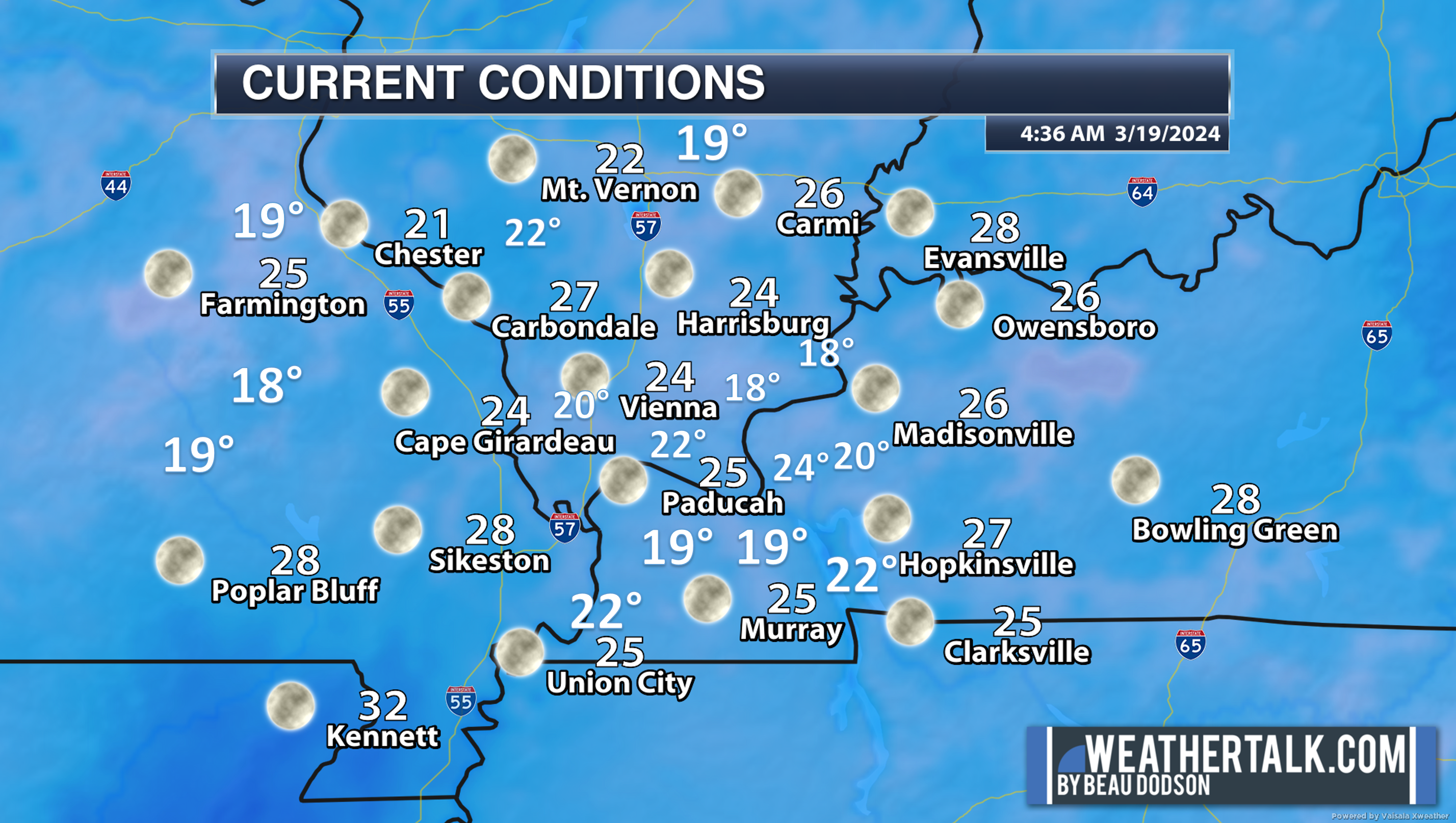
We are waking up to widespread upper teens to upper 20s. A wide range of temperatures.
It is not unusual to be this cold. Typically, our last 28 degree reading is around March 28th. So, this freeze falls within the typical time-range. We have simply been spoiled, once again, by early warmth.
There are always cold favored spots in the region and this morning is no different.
Double click graphics to enlarge them
4:30 AM temps
Dry conditions today with enhanced fire conditions. Don’t burn anything outside. Gusty winds will top 30 mph, from time to time.
Dry conditions today, tomorrow, and most of Thursday.
A weak southern system and northern system will bring some light showers to the region Thursday night into Friday. This whole system has been nothing but a struggle for the past week. Trying to figure out rain probabilities hasn’t been easy.
They have bounced between 10% to 40% over the past few days. Mostly in the 20% to 30% range. Either way, it appears that a few sprinkles and light showers will be possible Thursday night and Friday.
Rain totals of 0.01″ to 0.10″ will be possible. Many areas may completely miss out on the rain.
The rain probabilities will be a little bit higher over Kentucky and Tennessee.
I capped rain chances in the 20% to 30% range.
Not a big deal.
It will be chilly today, but a slow warming trend is likely Wednesday into the weekend.
We aren’t finished with overnight lows in the 30s. See the top of the page. Some additional frost chances will be possible this week. Perhaps even light freeze conditions near Mt Vernon. Again, see the detailed area by area forecast at the top of the page.
The next system arrives Sunday into Tuesday.
This is a larger more substantial rain event. Perhaps even some thunderstorms.
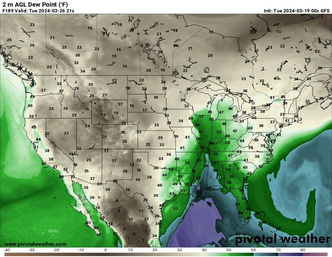
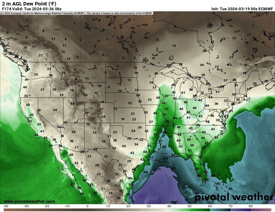
We aren’t quite sure about the severe weather threat. For now, it appears dew points may top out in the 50s. If that happens, then the threat for severe weather will be lower in our region. If dew points rise into the 60s, then we have problems.
It is still too soon to know if we will be in a severe weather threat zone Sunday night into Tuesday.
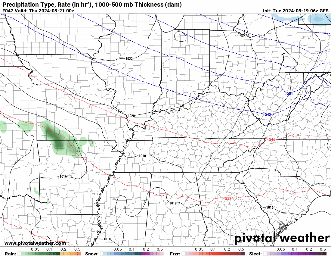
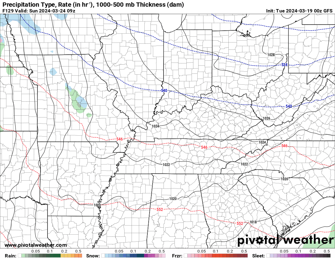
Here is what the GFS and EC show for dew points. The blue zone represents 60s. We want to stay out of the blue zone.
GFS
EC
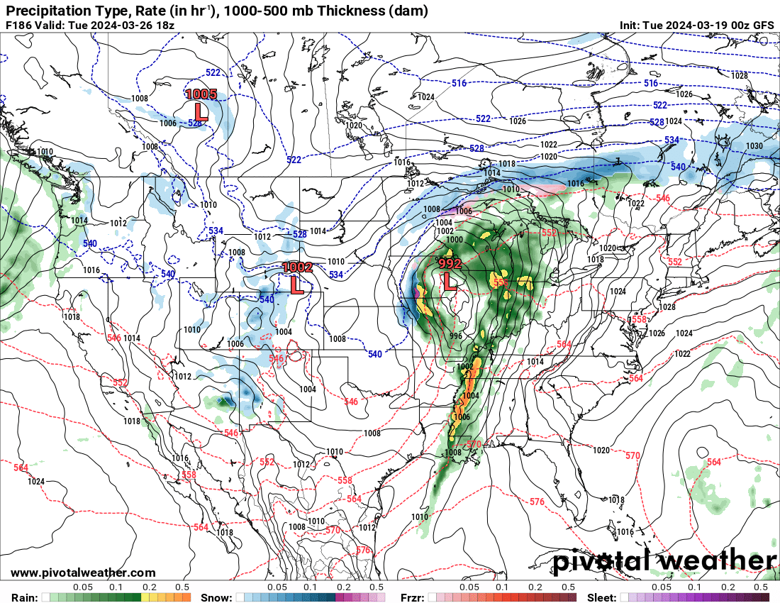
Here is the storm system
GFS model showing rain in our region Monday.
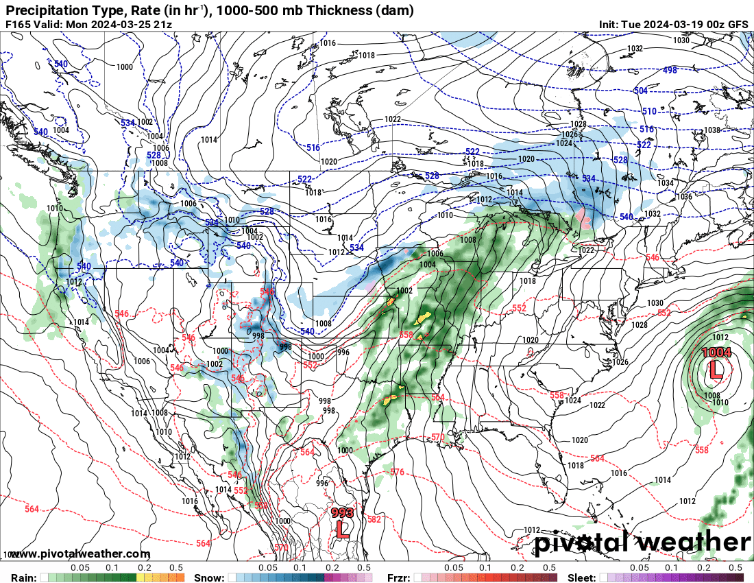
GFS model Monday evening.
Here is the EC model for Monday evening.
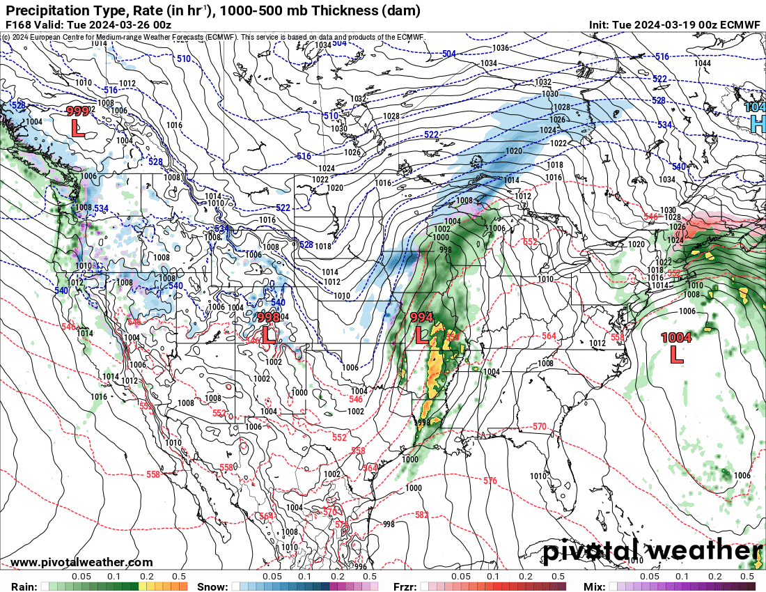
Rainfall totals could be locally heavy. I am looking at one to two inches.
There could be a second system come in right behind this first one. An additional wave of low pressure.
If that would happen, then rain totals would be higher.
Let’s keep an eye on early next week, just in case severe weather is a concern. I will know more Thursday. That is what I have been telling everyone.
For now, the severe risk appears limited, but still a bit early for a real forecast.
A few more storm systems behind this one over the coming two weeks. Monitor updates. It is spring!
![]()
.
Click here if you would like to return to the top of the page.
This outlook covers southeast Missouri, southern Illinois, western Kentucky, and far northwest Tennessee.

.
Today’s Storm Prediction Center’s (SPC) Severe Weather Outlook
Light green is where thunderstorms may occur but should be below severe levels.
Dark green is a level one risk. Yellow is a level two risk. Orange is a level three (enhanced) risk. Red is a level four (moderate) risk. Pink is a level five (high) risk.
One is the lowest risk. Five is the highest risk.
A severe storm is one that produces 58 mph wind or higher, quarter or larger size hail, and/or a tornado.
Explanation of tables. Click here.
Day One Severe Weather Outlook

Day One Severe Weather Outlook. Zoomed in on our region.

.
Day One Tornado Probability Outlook

Day One Regional Tornado Outlook. Zoomed in on our region.

.
Day One Large Hail Probability Outlook

Day One Regional Hail Outlook. Zoomed in on our region.

.
Day One High wind Probability Outlook

Day One Regional Wind Outlook. Zoomed in on our region.

.
Tomorrow’s severe weather outlook. Day two outlook.

Day Two Outlook. Zoomed in on our region.

.
Day Three Severe Weather Outlook

.

.
The images below are from NOAA’s Weather Prediction Center.
24-hour precipitation outlook..
 .
.
.
48-hour precipitation outlook.
. .
.
![]()
_______________________________________
.

Click here if you would like to return to the top of the page.
Again, as a reminder, these are models. They are never 100% accurate. Take the general idea from them.
What should I take from these?
- The general idea and not specifics. Models usually do well with the generalities.
- The time-stamp is located in the upper left corner.
.
What am I looking at?
You are looking at computer model data. Meteorologists use many different models to forecast the weather.
Occasionally, these maps are in Zulu time. 12z=7 AM. 18z=1 PM. 00z=7 PM. 06z=1 AM
Green represents light rain. Dark green represents moderate rain. Yellow and orange represent heavier rain.
.
This animation is the FVS Model.
Occasionally, these maps are in Zulu time. 12z=6 AM. 18z=12 PM. 00z=6 PM. 06z=12 AM
Double click images to enlarge them. Blue is snow. Pink is a wintry mix. Green is rain.
.
This animation is the NAM Model.
Occasionally, these maps are in Zulu time. 12z=6 AM. 18z=12 PM. 00z=6 PM. 06z=12 AM
Double click images to enlarge them.
.
This animation is the HRRR Model.
Green is rain. Yellow and orange are heavier rain. Pink is a wintry mix. Blue is snow. Dark blue is heavier snow.
Occasionally, these maps are in Zulu time. 12z=6 AM. 18z=12 PM. 00z=6 PM. 06z=12 AM
Double click images to enlarge them.
.
This animation is the GFS Model.
Green is rain. Yellow and orange are heavier rain. Pink is a wintry mix. Blue is snow. Dark blue is heavier snow.
Occasionally, these maps are in Zulu time. 12z=6 AM. 18z=12 PM. 00z=6 PM. 06z=12 AM
Double click images to enlarge them.
.
This animation is the EC Model.
Green is rain. Yellow and orange are heavier rain. Pink is a wintry mix. Blue is snow. Dark blue is heavier snow.
Occasionally, these maps are in Zulu time. 12z=6 AM. 18z=12 PM. 00z=6 PM. 06z=12 AM
Double click images to enlarge them.
..![]()

.
Click here if you would like to return to the top of the page.
.Average high temperatures for this time of the year are around 56 degrees.
Average low temperatures for this time of the year are around 36 degrees.
Average precipitation during this time period ranges from 0.60″ to 1.20″
Six to Ten Day Outlook.
Blue is below average. Red is above average. The no color zone represents equal chances.
Average highs for this time of the year are in the lower 60s. Average lows for this time of the year are in the lower 40s.
Check back for this graphic
Green is above average precipitation. Yellow and brown favors below average precipitation. Average precipitation for this time of the year is around one inch per week.
Check back for this graphic
.

Average low temperatures for this time of the year are around 38 degrees.
Average precipitation during this time period ranges from 0.60″ to 1.20″
.
Eight to Fourteen Day Outlook.
Blue is below average. Red is above average. The no color zone represents equal chances.
Check back for this graphic
Green is above average precipitation. Yellow and brown favors below average precipitation. Average precipitation for this time of the year is around one inch per week.
Check back for this graphic
.
![]()
The app is for subscribers. Subscribe at www.weathertalk.com/welcome then go to your app store and search for WeatherTalk
Subscribers, PLEASE USE THE APP. ATT and Verizon are not reliable during severe weather. They are delaying text messages.
The app is under WeatherTalk in the app store.

Apple users click here

Android users click here
.

Radars and Lightning Data
Interactive-city-view radars. Clickable watches and warnings.
https://wtalk.co/B3XHASFZ
If the radar is not updating then try another one. If a radar does not appear to be refreshing then hit Ctrl F5. You may also try restarting your browser.
Backup radar site in case the above one is not working.
https://weathertalk.com/morani
Regional Radar
https://imagery.weathertalk.com/prx/RadarLoop.mp4
** NEW ** Zoom radar with chaser tracking abilities!
ZoomRadar
Lightning Data (zoom in and out of your local area)
https://wtalk.co/WJ3SN5UZ
Not working? Email me at beaudodson@usawx.com
National map of weather watches and warnings. Click here.
Storm Prediction Center. Click here.
Weather Prediction Center. Click here.
.

Live lightning data: Click here.
Real time lightning data (another one) https://map.blitzortung.org/#5.02/37.95/-86.99
Our new Zoom radar with storm chases
.
.

Interactive GOES R satellite. Track clouds. Click here.
GOES 16 slider tool. Click here.
College of DuPage satellites. Click here
.

Here are the latest local river stage forecast numbers Click Here.
Here are the latest lake stage forecast numbers for Kentucky Lake and Lake Barkley Click Here.
.
.
Find Beau on Facebook! Click the banner.


 .
.