Monday Facebook link https://www.facebook.com/beaudodsonweather/
Monday, March 13, 2017: Welcome to the start of a new work week. Mother nature has decided that she would make up for January and February and deliver winter in March.
We have had three tornado and severe weather outbreaks and two snow events (counting today) since February 28th. That is an incredible amount of weather crammed into a short amount of time.
Snow, snow and rain mix, and rain is anticipated today. Perhaps some sleet pellets and freezing rain. The going thought is that temperatures will warm enough by late morning to change everything over to rain.
This is not a slam dunk forecast. There remain questions about where the rain and snow line should be drawn today. Some of the flakes could be big today. Half dollar size flakes were reported last night in southwest Missouri.
Some slushy accumulation is a good possibility. Ground temperatures are ranging from 48 to 52 degrees. Road temperatures are ranging from 38 to 42 degrees. Finally, air temperatures are in the lower to middle 30’s.
Watch the bridges, they freeze first.
High temperatures today should jump into the middle to upper 40’s. The snow, rain and snow might make for a slowing of the warming process.
We will have a chance for showers early this evening and then becoming partly cloudy. Lows tonight mostly in the lower 30’s.
A large winter storm/blizzard will take shape to our northeast over the coming 48 hours. This will help drive cold air into our region on Tuesday night.
Perhaps, the coldest night, of this recent string of cold days, will arrive on Tuesday night. Lows are currently forecast to range from 18 to 24 degrees. Let’s go with lower 20’s (at least it does not sound as bad).
Unfortunately, this will cause more damage to vegetation and fruit trees.
Dry weather Tuesday through Thursday morning.
I continue to watch another precipitation maker for late Thursday or Thursday night.
No severe weather anticipated this week. See, there was some good news at the end of the rainbow.
We have some great sponsors for the Weather Talk Blog. Please let our sponsors know that you appreciate their support for the Weather Talk Blog.

Are you in need of new eye glasses? New contacts? Perhaps you need an eye exam. Then be sure and visit the Eye Care Associates of western Kentucky (the Paducah location). For all of your families eye care needs.
Visit their web-site here. Or, you can also visit their Facebook page.

Best at Enabling Body Shop Profitability since 1996. Located In Paducah Kentucky and Evansville Indiana; serving all customers in between. They provide Customer Service, along with all the tools necessary for body shops to remain educated and competitive. Click the logo above for their main web-site.
You can find McClintock Preferred Finishes on Facebook, as well

Expressway Carwash and Express Lube are a locally owned and operated full-service Carwash and Lube established in 1987.
They have been proudly serving the community for 29 years now at their Park Avenue location and 20 years at their Southside location. They have been lucky enough to partner with Sidecar Deli in 2015, which allows them to provide their customers with not only quality service, but quality food as well.
If you haven’t already, be sure to make Expressway your one-stop shop, with their carwash, lube and deli. For hours of operation and pricing visit www.expresswashlube.com or Expressway Carwash on Facebook.

The quad states area source for Precision Ag Technology. Locally owned and operated, specializing in planting, harvesting, fertilizer application and drainage. Visit them on their website and on Facebook. You can also find them on Twitter. They are located in Almo, Kentucky. Phone 270-718-0245
.———————————————–
The Beau Dodson Weather APP is ready for Apple and Android users. The purpose of this APP is for me to deliver your text messages instantly. ATT and Verizon have not always been reliable when it comes to speed. The APP allows instant delivery.
Some of you have asked if you can keep receiving the texts on your phone and the app. The answer to that is, yes. The Android app will automatically allow that to happen. On the Apple app, however, you will need to go into your app and click settings. Make sure the green tab is OFF. Off means you will still receive the texts to your phone and the app. If you have any questions, then email me at beaudodson@usawx.com
The APP is for text subscribers.
The direct download, for the Apple app, can be viewed here
https://itunes.apple.com/us/app/id1190136514
If you have not signed up for the texting service then you may do so at www.beaudodsonweather.com

The Android APP is also ready.
Remember, the APP’s are for www.weathertalk.com subscribers. The app allows your to receive the text messages faster than ATT and Verizon.
Here is the download link for the Android version Click Here

——————————————————–
If you have not signed up for the texts messages, then please do. Link www.beaudodsonweather.com
Your support helps with the following:

and

.

This forecast update covers far southern Illinois, far southeast Missouri, and far western Kentucky. See the coverage map on the right side of the blog
.
Sunday Night Forecast Details:
Forecast: Increasing clouds. Cold. A chance for a wintry mix after 2 am. Probably mostly snow or snow/rain mix. Perhaps some slushy light accumulation.
What impacts are anticipated from the weather? Below freezing conditions anticipated. Some wintry mix possible late tonight moving in from the west. I can’t rule out some slushily light accumulation.
Is severe weather expected? No
The NWS defines severe weather as 58 mph winds or great, 1″ hail or larger, and/or tornadoes
What is the chance of precipitation? MO ~ 60% IL ~ 60% KY ~ 50% TN ~ 50%
Coverage of precipitation: Increasing precipitation after 2 am.
Should I cancel my outdoor plans? No.
My confidence in the forecast verifying: Medium. Some adjustments are possible.
Temperatures: MO ~ 28 to 32 IL ~ 28 to 32 KY ~ 28 to 32 TN ~ 28 to 32
Winds: East and northeast at 4 to 8 mph
Wind Chill when applicable:
Will there be a chance for wintry precipitation? Yes, perhaps some rain/snow or wintry mix late
Moonrise will be at 7:16 p.m. and moonset will be at 7:17 a.m. Full Moon
Interactive Weather Radar Page. Choose the city nearest your location: Click this link—
.
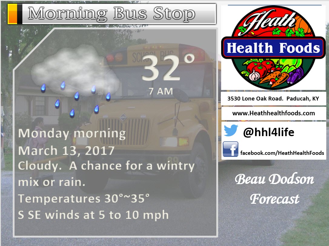
March 13, 2017
Monday Forecast Details
Forecast: Cloudy. Morning snow changing to rain/snow and then changing to all rain. A light slushy accumulation can’t be ruled out. No true impacts anticipated.
What impacts are anticipated from the weather? Wet roadways. Monitor the wintry mix time frame of 3 am to 10 am. Low confidence.
Is severe weather expected? No.
The NWS defines severe weather as 58 mph winds or great, 1″ hail or larger, and/or tornadoes
What is the chance of precipitation? MO ~ 70% IL ~ 80% KY ~ 70% TN ~ 60%
Coverage of precipitation: Perhaps numerous
Should I cancel my outdoor plans? Monitor updates. Perhaps have a plan B.
My confidence in the forecast verifying: Medium. Some adjustments are possible.
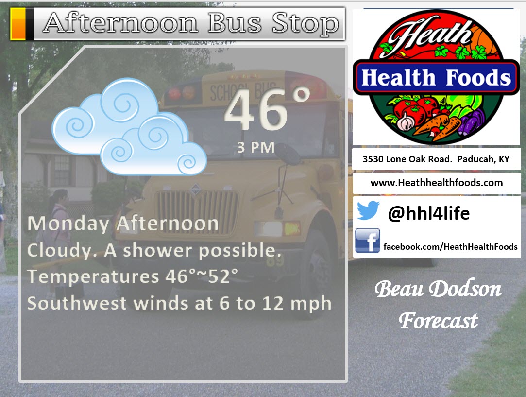
Temperatures: MO ~ 45 to 50 IL ~ 45 to 50 KY ~ 45 to 50 TN ~ 46 to 52
Winds: Variable winds at 5 to 10 mph/ Winds becoming southwest at 5 to 10 mph
Will there be a chance for wintry precipitation? Snow showers possible. Light slushy accumulation can’t be ruled out. No true impacts.
Sunrise will be at 7:06 a.m. and sunset will be at 7:00 p.m.
UV Index: 0 to 1
Moonrise will be at 8:14 p.m. and moonset will be at 7:50 a.m. Waning Gibbous
Monday Night Forecast Details:
Forecast: Partly to mostly cloudy. Precipitation ending. Cold.
What impacts are anticipated from the weather? Freeze likely.
Is severe weather expected? No
The NWS defines severe weather as 58 mph winds or great, 1″ hail or larger, and/or tornadoes
What is the chance of precipitation? MO ~ 20% IL ~ 30% KY ~ 30% TN ~ 30%
Coverage of precipitation: Ending.
Should I cancel my outdoor plans? No, but it will be cold.
My confidence in the forecast verifying: Medium. Some adjustments are possible.
Temperatures: MO ~ 28 to 32 IL ~ 28 to 32 KY ~ 28 to 32 TN ~ 28 to 32
Winds: North and northwest at 4 to 8 mph
Wind Chill when applicable:
Will there be a chance for wintry precipitation? No
Moonrise will be at 8:14 p.m. and moonset will be at 7:50 a.m. Waning Gibbous
.
March 14, 2017
Tuesday Forecast Details
Forecast: Mix of sun and clouds. Some data shows mostly cloudy sky conditions. Cool temperatures.
What impacts are anticipated from the weather? None
Is severe weather expected? No.
The NWS defines severe weather as 58 mph winds or great, 1″ hail or larger, and/or tornadoes
What is the chance of precipitation? MO ~ 0% IL ~ 0% KY ~ 0% TN ~ 0%
Coverage of precipitation: None
Should I cancel my outdoor plans? No
My confidence in the forecast verifying: High. This forecast should verify.
Temperatures: MO ~ 38 to 42 IL ~ 38 to 42 KY ~ 38 to 44 TN ~ 38 to 44
Winds: North and northwest at 10 to 20 mph
Will there be a chance for wintry precipitation? No.
Sunrise will be at 7:05 a.m. and sunset will be at 7:01 p.m.
UV Index: 0 to 4
Moonrise will be at 9:12 p.m. and moonset will be at 8:22 a.m. Waning Gibbous
Tuesday Night Forecast Details:
Forecast: A few clouds and cold. Hard freeze likey.
What impacts are anticipated from the weather? Freeze conditions.
Is severe weather expected? No
The NWS defines severe weather as 58 mph winds or great, 1″ hail or larger, and/or tornadoes
What is the chance of precipitation? MO ~ 0% IL ~ 0% KY ~ 0% TN ~ 0%
Coverage of precipitation: None
Should I cancel my outdoor plans? No.
My confidence in the forecast verifying: Medium. Some adjustments are possible.
Temperatures: MO ~ 18 to 24 IL ~ 18 to 24 KY ~ 20 t o 24 TN ~ 22 to 25
Winds: North and northeast at 5 mph
Wind Chill when applicable:
Will there be a chance for wintry precipitation? No
Moonrise will be at 9:12 p.m. and moonset will be at 8:22 a.m. Waning Gibbous
.
March 15, 2017
Wednesday Forecast Details
Forecast: Mostly sunny. Cold.
What impacts are anticipated from the weather? None
Is severe weather expected? No.
The NWS defines severe weather as 58 mph winds or great, 1″ hail or larger, and/or tornadoes
What is the chance of precipitation? MO ~ 0% IL ~ 0% KY ~ 0% TN ~ 0%
Coverage of precipitation: None
Should I cancel my outdoor plans? No
My confidence in the forecast verifying: High. This forecast should verify.
Temperatures: MO ~ 38 to 42 IL ~ 38 to 42 KY ~ 38 to 44 TN ~ 38 to 44
Winds: North wind at 8 mph
Will there be a chance for wintry precipitation? No.
Sunrise will be at 7:03 a.m. and sunset will be at 7:02 p.m.
UV Index: 3 to 6
Moonrise will be at 10:09 p.m. and moonset will be at 8:54 a.m. Waning Gibbous
Wednesday Night Forecast Details:
Forecast: Mostly clear with hard freeze possible.
What impacts are anticipated from the weather? Freeze conditions.
Is severe weather expected? No
The NWS defines severe weather as 58 mph winds or great, 1″ hail or larger, and/or tornadoes
What is the chance of precipitation? MO ~ 0% IL ~ 0% KY ~ 0% TN ~ 0%
Coverage of precipitation: None
Should I cancel my outdoor plans? No.
My confidence in the forecast verifying: Medium. Some adjustments are possible.
Temperatures: MO ~ 23 to 26 IL ~ 22 to 26 KY ~ 24 to 26 TN ~ 24 to 26
Winds: North and northeast at 5 mph
Wind Chill when applicable:
Will there be a chance for wintry precipitation? No
Moonrise will be at 10:09 p.m. and moonset will be at 8:54 a.m. Waning Gibbous
.
March 16, 2017
Thursday Forecast Details
Forecast: A mix of sun and clouds. A slight chance for showers over southeast Missouri.
What impacts are anticipated from the weather? None
Is severe weather expected? No.
The NWS defines severe weather as 58 mph winds or great, 1″ hail or larger, and/or tornadoes
What is the chance of precipitation? MO ~ 0% IL ~ 0% KY ~ 0% TN ~ 0%
Coverage of precipitation: None to isolated
Should I cancel my outdoor plans? No
My confidence in the forecast verifying: High. This forecast should verify.
Temperatures: MO ~ 45 to 50 IL ~ 45 to 50 KY ~45 to 50 TN ~ 45 to 50
Winds: South and southeast winds at 5 to 10 mph
Will there be a chance for wintry precipitation? No.
Sunrise will be at 7:02 a.m. and sunset will be at 7:03 p.m.
UV Index: 3 to 6
Moonrise will be at 11:04 p.m. and moonset will be at 9:27 a.m. Waning Gibbous
Thursday Night Forecast Details:
Forecast: Partly to mostly cloudy. A 20% chance for showers. Cool.
What impacts are anticipated from the weather? None.
Is severe weather expected? No
The NWS defines severe weather as 58 mph winds or great, 1″ hail or larger, and/or tornadoes
What is the chance of precipitation? MO ~ 20% IL ~ 20% KY ~ 20% TN ~ 20%
Coverage of precipitation: Scattered
Should I cancel my outdoor plans? No.
My confidence in the forecast verifying: Low. Significant adjustments are possible.
Temperatures: MO ~ 32 to 36 IL ~ 32 to 36 KY ~ 32 to 36 TN ~ 32 to 36
Winds: South at 5 mph
Wind Chill when applicable:
Will there be a chance for wintry precipitation? Unlikely
Moonrise will be at 11:04 p.m. and moonset will be at 9:27 a.m. Waning Gibbous
.
March 17, 2017
Friday Forecast Details
Forecast: Cloudy with a chance for showers.
What impacts are anticipated from the weather? Wet roadways
Is severe weather expected? No.
The NWS defines severe weather as 58 mph winds or great, 1″ hail or larger, and/or tornadoes
What is the chance of precipitation? MO ~ 30% IL ~ 30% KY ~ 30% TN ~ 30%
Coverage of precipitation: Spotty
Should I cancel my outdoor plans? No, but monitor updates
My confidence in the forecast verifying: High. This forecast should verify.
Temperatures: MO ~ 46 to 52 IL ~ 46 to 52 KY ~ 46 to 52 TN ~ 46 to 54
Winds: South winds at 6 to 12 mph
Will there be a chance for wintry precipitation? No.
Sunrise will be at 7:00 a.m. and sunset will be at 7:04 p.m.
UV Index: 0 to 2
Moonrise will be at 11:59 p.m. and moonset will be at 10:02 a.m. Waning Gibbous
Friday Night Forecast Details:
Forecast: Cloudy. Showers possible.
What impacts are anticipated from the weather? Wet roadways
Is severe weather expected? No
The NWS defines severe weather as 58 mph winds or great, 1″ hail or larger, and/or tornadoes
What is the chance of precipitation? MO ~ 30% IL ~ 30% KY ~ 30% TN ~ 30%
Coverage of precipitation: Scattered
Should I cancel my outdoor plans? No, but monitor updates.
My confidence in the forecast verifying: Medium. Some adjustments are possible.
Temperatures: MO ~ 40 to 44 IL ~ 40 to 44 KY ~ 40 to 44 TN ~ 40 to 44
Winds: Southwest at 5 to 10 mph
Wind Chill when applicable:
Will there be a chance for wintry precipitation? No
Moonrise will be at 11:59 p.m. and moonset will be at 10:02 a.m. Waning Gibbous
.
March 18, 2017
Saturday Forecast Details
Forecast: Mostly sunny.
What impacts are anticipated from the weather? None
Is severe weather expected? No.
The NWS defines severe weather as 58 mph winds or great, 1″ hail or larger, and/or tornadoes
What is the chance of precipitation? MO ~ 0% IL ~ 0% KY ~ 0% TN ~ 0%
Coverage of precipitation: None
Should I cancel my outdoor plans? No
My confidence in the forecast verifying: High. This forecast should verify.
Temperatures: MO ~ 50 to 55 IL ~ 50 to 55 KY ~ 50 to 55 TN ~ 50 to 55
Winds:
Will there be a chance for wintry precipitation? No.
Sunrise will be at 6:59 a.m. and sunset will be at 7:05 p.m.
UV Index: 5 to 8
Moonrise will be at -:– p.m. and moonset will be at 10:39 a.m. Waning Gibbous
Saturday Night Forecast Details:
Forecast: A few clouds.
What impacts are anticipated from the weather?
Is severe weather expected? No
The NWS defines severe weather as 58 mph winds or great, 1″ hail or larger, and/or tornadoes
What is the chance of precipitation? MO ~ 0% IL ~ 0% KY ~ 0% TN ~ 0%
Coverage of precipitation: None
Should I cancel my outdoor plans? No.
My confidence in the forecast verifying: Medium. Some adjustments are possible.
Temperatures: MO ~ 40 to 45 IL ~ 40 to 44 KY ~ 42 to 46 TN ~ 42 to 46
Winds:
Wind Chill when applicable:
Will there be a chance for wintry precipitation? No
Moonrise will be at -:– p.m. and moonset will be at 10:39 a.m. Waning Gibbous
More information on the UV index. Click here
The School Bus Stop Forecast is sponsored by Heath Health and Wellness.
Located next to Crowell Pools in Lone Oak, Kentucky.
Visit their website here. Visit Heath Health Foods on Facebook!

Heath Health Foods is a locally owned and operated retail health and wellness store. Since opening in February 2006; the store has continued to grow as a ministry with an expanding inventory which also offers wellness appointments and services along with educational opportunities.
Visit their web-site here. And. visit Heath Health Foods on Facebook!.


Don’t forget to check out the Southern Illinois Weather Observatory web-site for weather maps, tower cams, scanner feeds, radars, and much more! Click here

An explanation of what is happening in the atmosphere over the coming day
Analysis
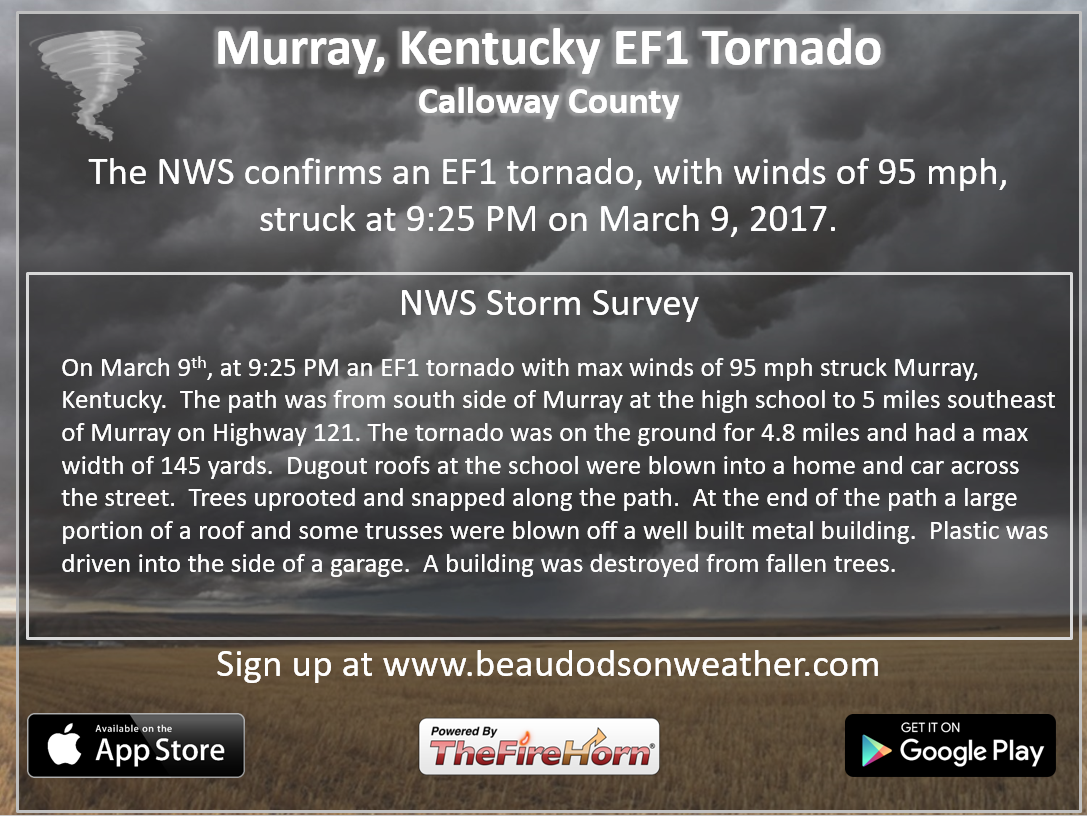
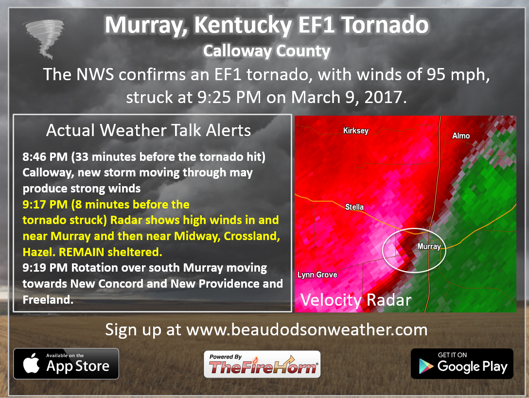
Another tornado was confirmed from March 9th. Here are some of the texts I sent out. There were quite a few that night.
I will work on some more confirmation graphics, when I have some extra time.
The texts are working well during tornado and severe weather events.
Sunday night into Monday night:
Confidence: High
Clouds will increase on Sunday night in response to an incoming storm system. It might be cold enough, late Sunday night, to produce some patchy wintry mix. It won’t last long. Temperatures on Monday should climb well above freezing.
I can’t rule out some slushy light accumulation. No true impacts to travel are expected. We will see if the snow can accumulate. Ground temperatures are near 50 degrees.
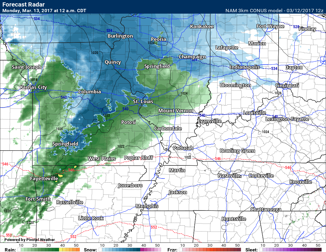
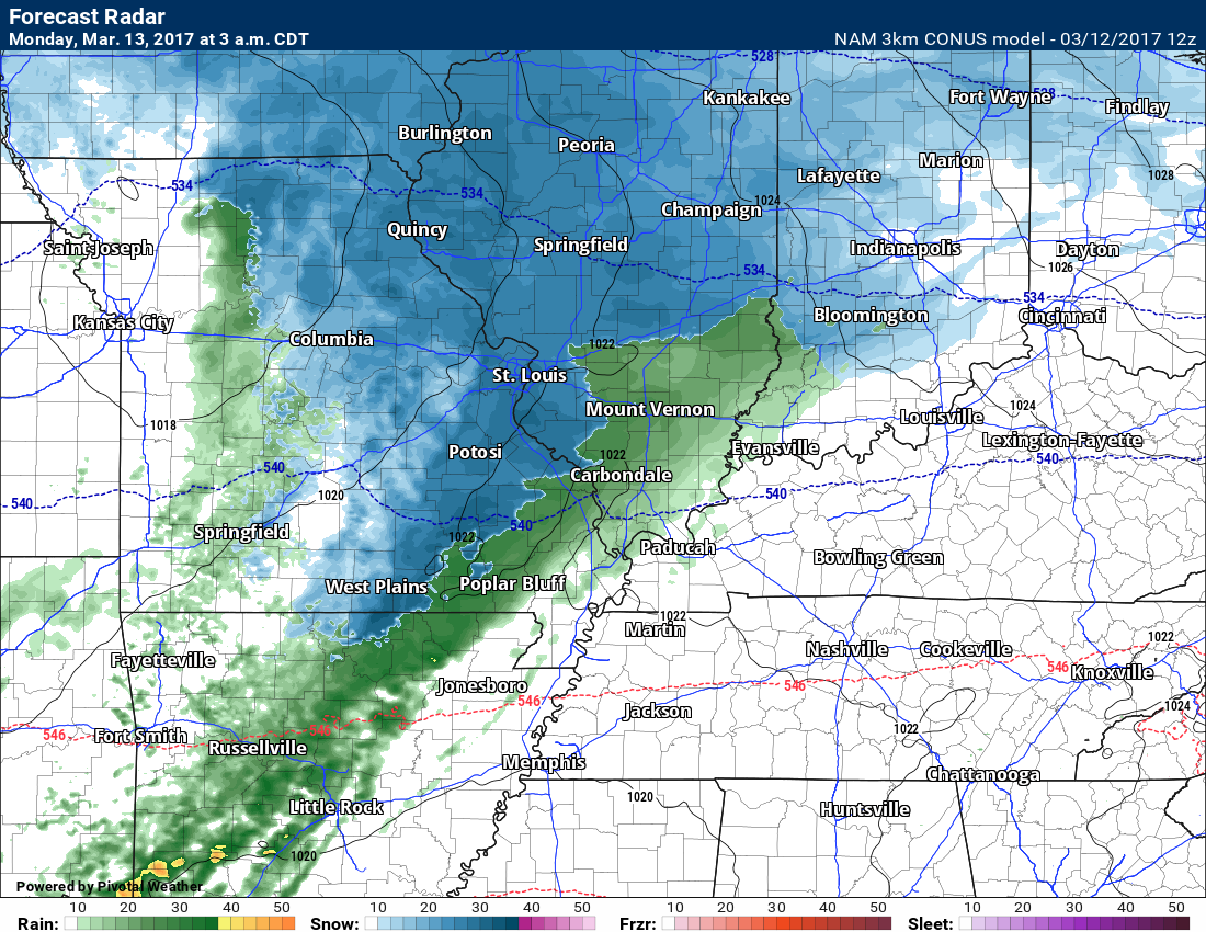
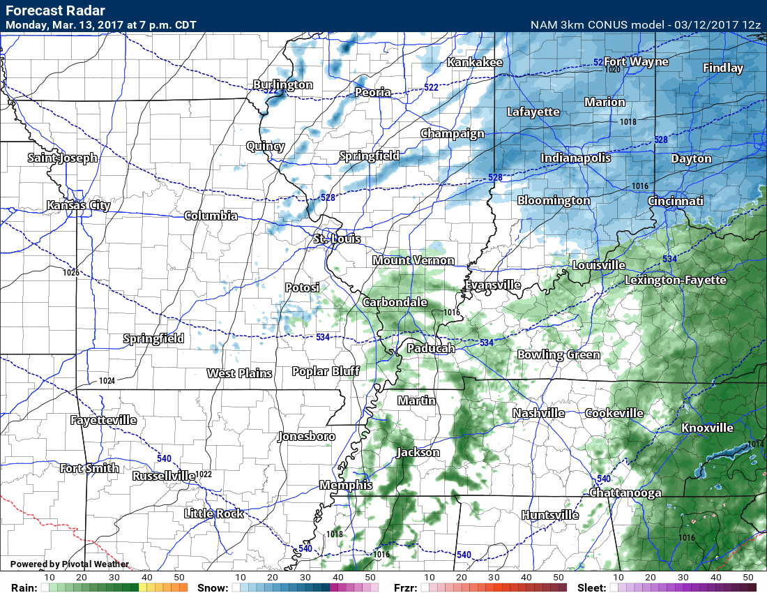
Future-cast radar from the high res 13K NAM guidance
12 AM Monday morning. Rain is green and snow is blue.
The NAM shows quite a bit of snow on this map.
Monday 3 AM future-cast radar
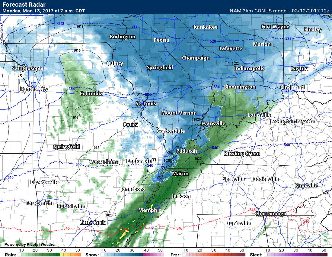
7 AM future-cast radar.
Remember, this is a model. Models can vary in their solutions.
Not sure there will be that much snow on radar. There should be some snow or wintry mix on Monday morning, but temperatures should rise above freezing fairly early in the day. That is the forecast plan, at least.
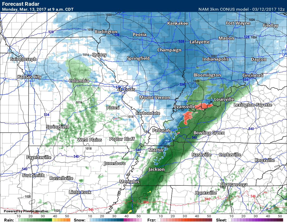
9 AM future-cast radar
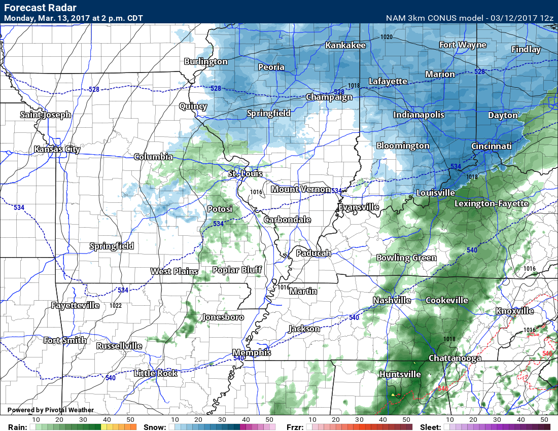
2 PM future-cast radar
7 PM future-cast radar
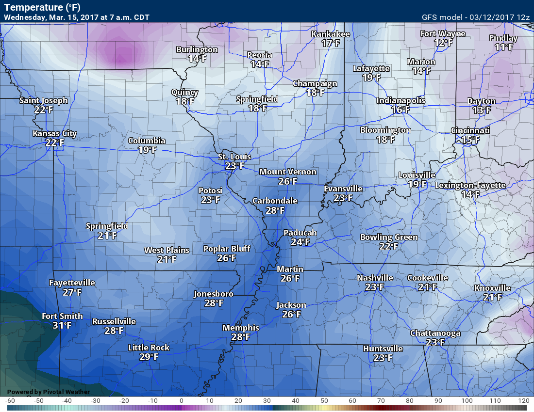
We should dry out on Monday night. Perhaps some clouds left and a small chance for precipitation. Lows by Tuesday morning will have fallen into the upper 20’s to lower 30’s.
Tuesday into Thursday:
Confidence: High
At this time, dry conditions are anticipated through Thursday. Cool, as well.
The coldest night should be Tuesday night. Guidance shows temperatures falling into the lower to middle 20’s. Another hard freeze.
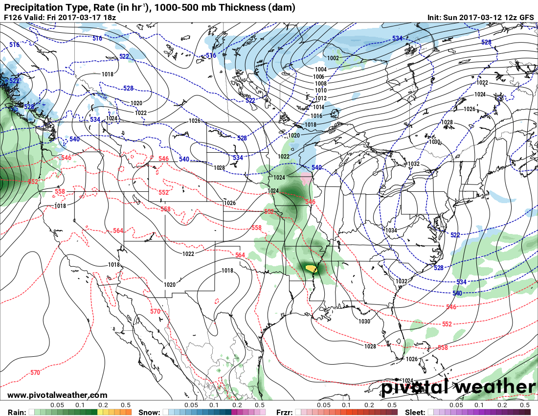
Friday into Sunday:
Confidence: Low
Rain chances may increase again by Friday and Saturday.
Here is the GFS for Friday. Some spotty showers. I will monitor trends.
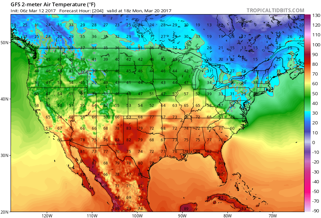
GFS shows a decent warm up by the 20th. Long cool spell for March. We were spoiled all winter.
.
Find me on Twitter

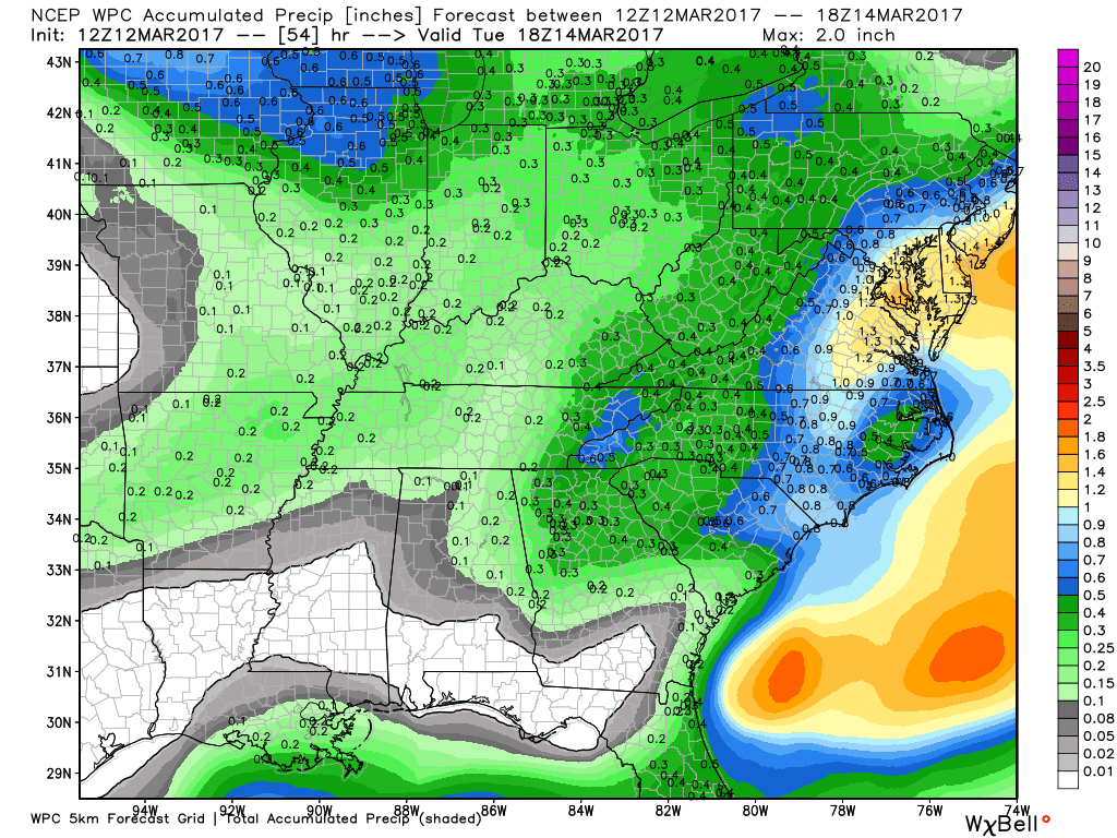
How much rain is expected over the coming days?
Here is the official NOAA rainfall prediction
Some rain and frozen precipitation again possible late Sunday night and Monday. Totals from 0.05″ to 0.25″ possible.
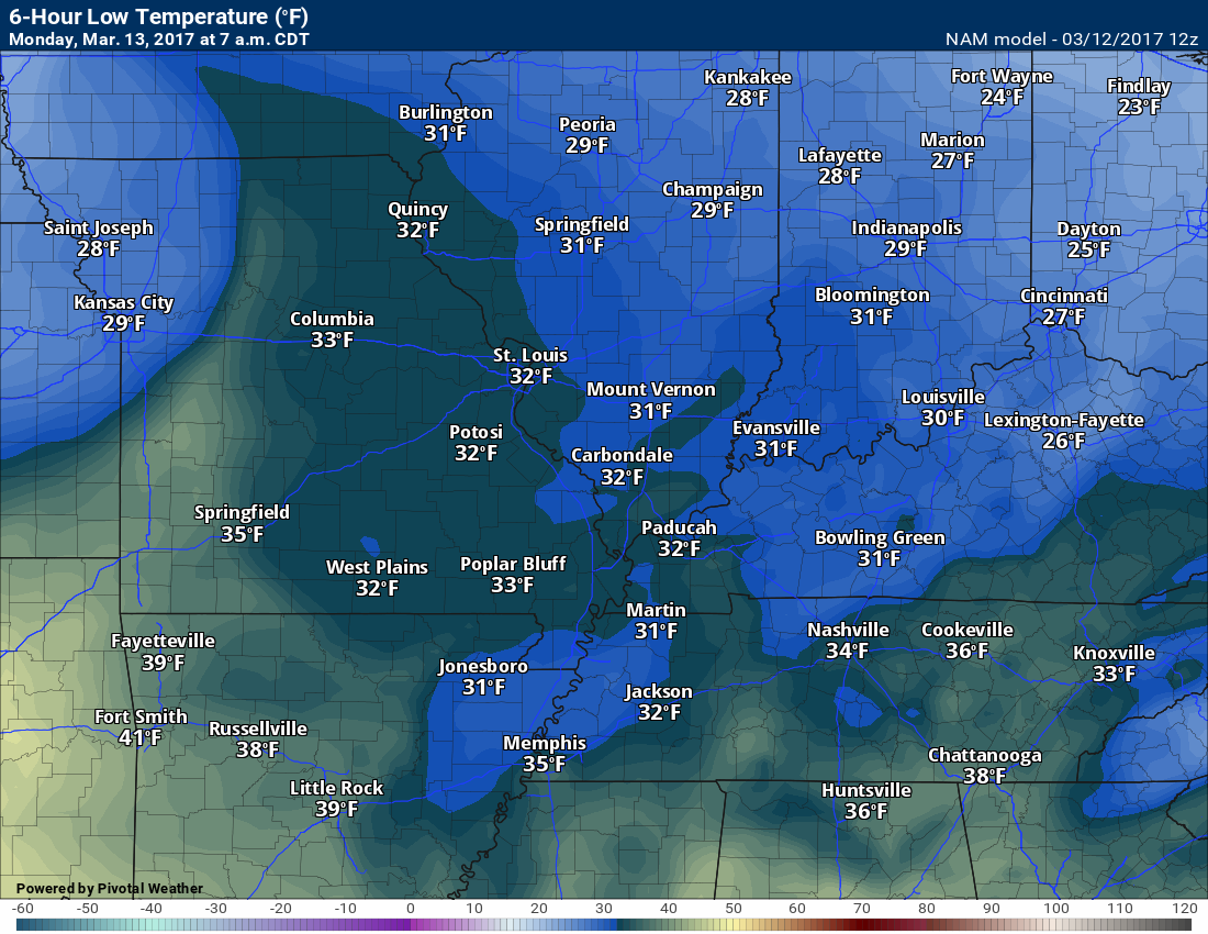
High and Low-Temperature Outlook
Monday low temperature forecast
Monday high temperature forecast
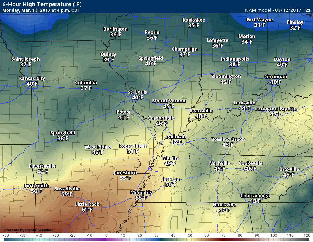

Freeze conditions on and off over the coming days. Tuesday night will likely be one of the colder nights with temperatures potentially reaching the lower 20’s.

Severe thunderstorm outlook.
Remember that a severe thunderstorm is defined as a thunderstorm that produces 58 mph winds or higher, quarter size hail or larger, and/or a tornado.
Monday into Saturday: Severe thunderstorms are not anticipated.

We have regional radars and local city radars – if a radar does not update then try another one. Occasional browsers need their cache cleared. You may also try restarting your browser. That usually fixes the problem. Occasionally we do have a radar go down. That is why I have duplicates. Thus, if one fails then try another one.
During the winter you can track snow and ice by clicking the winterize button on the local city view interactive radars.
If you have any problems then please send me an email beaudodson@usawx.com
Interactive Weather Radar Page. Choose the city nearest your location: Click this link—
National interactive radar: Click this link.
Local interactive city radars include St Louis, Mt Vernon, Evansville, Poplar Bluff, Cape Girardeau, Marion, Paducah, Hopkinsville, Memphis, Nashville, Dyersburg, and all of eastern Kentucky. These are interactive radars. Local city radars – click here
Regional Radar


Here are the current river stage forecasts. You can click your state and then the dot for your location. It will bring up the full forecast and hydrograph.
..

The official 6-10 day and 8-14 day temperature and precipitation outlook. Check the date stamp at the top of each image (so you understand the time frame).
The forecast maps below are issued by the Weather Prediction Center (NOAA)


The latest 8-14 day temperature and precipitation outlook. Note the dates are at the top of the image. These maps DO NOT tell you how high or low temperatures or precipitation will be. They simply give you the probability as to whether temperatures or precipitation will be above or below normal.


Who do you trust for your weather information and who holds them accountable?
I have studied weather in our region since the late 1970’s. I have 39 years of experience in observing our regions weather patterns. My degree is in Broadcast Meteorology and a Bachelor’s of Science.
My resume includes:
Member of the American Meteorological Society.
NOAA Weather-Ready Nation Ambassador.
Meteorologist for McCracken County Emergency Management. I served from 2005 through 2015.
Meteorologist for McCracken County Rescue. 2015 through current
I own and operate the Southern Illinois Weather Observatory.
I am the chief meteorologist for Weather Talk LLC. I am the owner of Weather Talk LLC.
I am also a business owner in western Kentucky.
Recipient of the Mark Trail Award, WPSD Six Who Make A Difference Award, Kentucky Colonel, and the Caesar J. Fiamma” Award from the American Red Cross.
In 2005 I helped open the largest American Cross shelter in U.S. history in Houston, Texas. I was deployed to help after Hurricane Katrina and Hurricane Rita. I was a shelter manager of one of the Houston, Texas shelter divisions.
In 2009 I was presented with the Kentucky Office of Highway Safety Award.
Recognized by the Kentucky House of Representatives for my service to the State of Kentucky leading up to several winter storms and severe weather outbreaks.
If you click on the image below you can read the Kentucky House of Representatives Resolution.

I am also President of the Shadow Angel Foundation which serves portions of western Kentucky and southern Illinois.
There is a lot of noise on the internet. A lot of weather maps are posted without explanation. Over time you should learn who to trust for your weather information.
My forecast philosophy is simple and straight forward.
- Communicate in simple terms
- To be as accurate as possible within a reasonable time frame before an event
- Interact with you on Twitter, Facebook, email, texts, and this blog
- Minimize the “hype” that you might see on some television stations or through other weather sources
- Push you towards utilizing wall-to-wall LOCAL TV coverage during severe weather events
Many of the graphics on this page are from www.weatherbell.com
WeatherBell is a great resource for weather model guidance.


You can sign up for my AWARE email by clicking here I typically send out AWARE emails before severe weather, winter storms, or other active weather situations. I do not email watches or warnings. The emails are a basic “heads up” concerning incoming weather conditions