We have some great sponsors for the Weather Talk Blog. Please let our sponsors know that you appreciate their support for the Weather Talk Blog.
Milner and Orr Funeral Home and Cremation Services located in Paducah, Kentucky and three other western Kentucky towns – at Milner and Orr they believe in families helping families. You can find Milner and Orr on Facebook, as well.
![]()
.

For all of your families eye care needs. Visit their web-site here. Or, you can also visit their Facebook page.
.

Best at Enabling Body Shop Profitability since 1996. Located In Paducah Kentucky and Evansville Indiana; serving all customers in between. They provide Customer Service, along with all the tools necessary for body shops to remain educated and competitive. Click the logo above for their main web-site. You can find McClintock Preferred Finishes on Facebook, as well

Expressway Carwash and Express Lube are a locally owned and operated full service Carwash and Lube established in 1987. They have been proudly serving the community for 29 years now at their Park Avenue location and 20 years at their Southside location. They have been lucky enough to partner with Sidecar Deli in 2015, which allows them to provide their customers with not only quality service, but quality food as well. . If you haven’t already, be sure to make Expressway your one stop shop, with their carwash, lube and deli. For hours of operation and pricing visit www.expresswashlube.com or Expressway Carwash on Facebook.

TORNADO SHELTERS! Endrizzi’s Storm Shelters – For more information click here. Endrizzi Contracting and Landscaping can be found on Facebook, as well – click here
I have launched the new weather texting service! I could use your help. Be sure and sign up and fully support all of the weather data you see each day.
This is a monthly subscription service. Supporting this helps support everything else. The cost is $3 a month for one phone, $5 a month for three phones, and $10 a month for seven phones.
For more information visit BeauDodsonWeather.com
Or directly sign up at Weathertalk.com


This forecast update covers far southern Illinois, far southeast Missouri, and far western Kentucky. See the coverage map on the right side of the blog.
Remember that weather evolves. Check back frequently for updates, especially during active weather.


.
The rest of Tuesday afternoon: A mix of sun and clouds. Hot and humid. A chance for scattered heavy thunderstorms. High temperatures from 88 to 94 degrees. West and southwest winds at 6-12 mph. Winds will be gusty near thunderstorms.
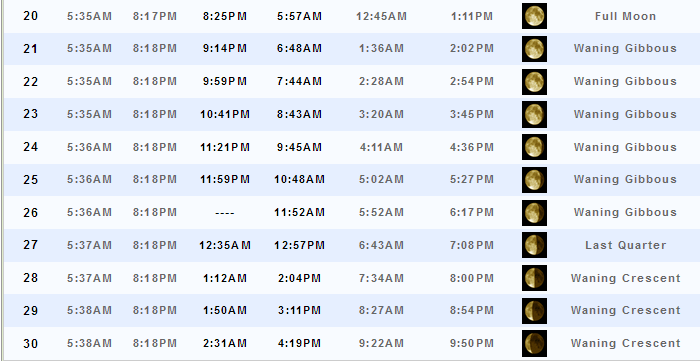
Moonrise will be at 9:14 p.m. and moonset will be at 6:48 a.m. Waning Gibbous.
Tuesday Night – Partly cloudy. Warm. Humid. A locally heavy thunderstorm possible.
What impact is expected? Lightning, heavy downpours, and gusty winds. Small chance that a couple of storms could produce dime to nickel size hail. Wet roadways.
Temperatures: Lows in the 72-76 degree range
Winds: Winds variable at 5-10 mph.
What is the chance for precipitation? 30%-40%
Coverage of precipitation: Scattered
Is severe weather expected? Isolated severe weather risk. Damaging wind would be the main concern. Frequent lightning, as well. Late tonight a few storms could form ahead of a warm front and produce hail. Best chance for that would be over our northern counties. Northern parts of southern Illinois and perhaps into northwest Kentucky. Better chances will remain well north of our region.
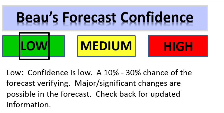
My confidence in this part of the forecast verifying? Medium
Should I cancel my outdoor plans? No, but monitor radars. Storms are possible. And, this could disrupt outdoor activities.
.
Wednesday – Partly to mostly sunny. Hot and humid. Breezy, at times. A chance for a few morning storms. Then, mostly dry the rest of the day. There is a slight chance for a thunderstorm during the afternoon hours. If a storm were to form then it would be intense. Overall, confidence is low that storms would form after 12 pm.
What impact is expected? If storms occur then wet roadways and lightning. Locally heavy rain. If afternoon storms form then they could produce high winds and hail. Lower confidence on the afternoon storms forming.
Temperatures: High temperatures in the 92-96 degree range with heat index values above 104 degrees.
Winds: South and west winds at 7-14 mph with gusts to 20-30 mph
What is the chance for precipitation? 20% before 12 p.m. and 10% after 12 p.m.
Coverage of precipitation? Scattered during the morning. Then, isolated during the afternoon hours.
Is severe weather expected? Most likely no. But, monitor updates. If storms were to pop during the afternoon they could produce damaging winds and hail. Low confidence that storms would actually form on Wednesday afternoon.
My confidence in this part of the forecast verifying: High
Should I cancel my outdoor plans? No, but a few storms are possible. Especially true for the morning hours.
Sunrise will be at 5:35 a.m. and sunset will be at 8:18 p.m.
UV index will be 10-11. Very high.
Moonrise will be at 9:59 p.m. and moonset will be at 7:44 a.m. Waning Gibbous.
Wednesday Night – Partly cloudy. Warm. Humid. An isolated thunderstorm possible. Perhaps a little better chance over northwest Kentucky.
What impact is expected? If any storms occur then they would produce lightning, gusty winds, and heavy downpours. Wet roadways. Small risk for damaging winds. Low confidence on storms occurring Wednesday evening and night.
Temperatures: Lows in the 74-78 degree range
Winds: Winds southwest at 7-14 mph. Gusting to 20 mph. Winds becoming variable after midnight with speeds of 6-12 mph.
What is the chance for precipitation? 20%
Coverage of precipitation: Isolated
Is severe weather expected? Most likely no. But, monitor updated forecasts.
My confidence in this part of the forecast verifying: Medium
Should I cancel my outdoor plans? No, but glance at radar from time to time.
.
Thursday – Partly to mostly sunny. Hot. Scattered thunderstorms likely. A few storms could be heavy.
What impact is expected? Wet roadways and lightning. Gusty winds and heavy downpours in storms. Small hail possible, as well.
Temperatures: High temperatures in the 92-96 degree range. Heat index values could rise above 100 degrees.
Winds: Variable winds at 7-14 mph with gusts to 25 mph. Stronger near storms, as always.
What is the chance for precipitation? 50%
Coverage of precipitation? Scattered to perhaps numerous
Is severe weather expected? Isolated risk for damaging winds and hail.
My confidence in this part of the forecast verifying: Medium
Should I cancel my outdoor plans? No, but monitor radars. A cold front will return to the region on Thursday. Some storms are likely to occur.
Sunrise will be at 5:35 a.m. and sunset will be at 8:18 p.m.
UV index will be 8-10. Very high.
Moonrise will be at 10:41 p.m. and moonset will be at 8:43 a.m. Waning Gibbous.
Thursday Night – Evening clouds. Then, partly cloudy. A thunderstorm possible.
What impact is expected? Lightning, heavy downpours, gusty winds.
Temperatures: Lows in the 72-76 degree range
Winds: Winds west and northwest at 4-8 mph. Gusts to 18 mph.
What is the chance for precipitation? 40%-50%
Coverage of precipitation: Isolated
Is severe weather expected? Unlikely
My confidence in this part of the forecast verifying: Medium
Should I cancel my outdoor plans? No, but monitor radars. Some storms are possible, especially during the evening hours.
.
Friday – Partly to mostly sunny. Hot. A thunderstorm possible. Low confidence on storms Friday into the weekend.
What impact is expected? If storms form then lightning, gusty winds, small hail, and heavy downpours.
Temperatures: High temperatures in the 88-94 degree range. Heat index values may top 100 degrees
Winds: Variable winds at 5-10 mph with gusts to 15 mph.
What is the chance for precipitation? 30%
Coverage of precipitation? Isolated to scattered
Is severe weather expected? Unlikely, but a few storms could be strong (if they develop)
My confidence in this part of the forecast verifying: Medium
Should I cancel my outdoor plans? No
Sunrise will be at 5:36 a.m. and sunset will be at 8:18 p.m.
UV index will be 9-11. Very high.
Moonrise will be at 11:21 p.m. and moonset will be at 9:45 a.m. Waning Gibbous.
Friday Night – Partly cloudy. A thunderstorm again possible.
What impact is expected? If storms form then lightning, gusty winds, small hail, and heavy downpours.
Temperatures: Lows in the 68-74 degree range
Winds: Winds west and northwest at 5-10 mph.
What is the chance for precipitation? 30%
Coverage of precipitation: Isolated to perhaps scattered
Is severe weather expected? Unlikely.
My confidence in this part of the forecast verifying: Medium
Should I cancel my outdoor plans? No
.
Saturday – Partly to mostly sunny. Hot. Low confidence on Saturday and Sunday’s forecast. Maybe a few storms. Some guidance shows better chances for storms than other guidance. I don’t have a lot of confidence in the weekend forecast. Thus, check back for updates.
What impact is expected? If storms form then lightning, gusty winds, heavy downpours, and small hail possible.
Temperatures: High temperatures in the 90-96 degree range. Heat index values above 100 degrees.
Winds: Variable winds at 5-10 mph with gusts to 14 mph
What is the chance for precipitation? 20%-30% (this could change)
Coverage of precipitation? Isolated. But, low confidence on this part of the forecast.
Is severe weather expected? Unlikely. Although, if storms were to form they could be strong with gusty winds and even small hail.
My confidence in this part of the forecast verifying: Low
Should I cancel my outdoor plans? No
Sunrise will be at 5:36 a.m. and sunset will be at 8:18 p.m.
UV index will be 10-11. Very high.
Moonrise will be at 11:59 p.m. and moonset will be at 10:48 a.m. Waning Gibbous.
Saturday Night – Partly cloudy. Very warm. Humid. A thunderstorm possible.
What impact is expected? If storms form then wet roadways, lightning, and gusty winds.
Temperatures: Lows in the 72-76 degree range
Winds: Winds west and southwest at 5-10 mph.
What is the chance for precipitation? 10%-20%
Coverage of precipitation: Isolated
Is severe weather expected? No
My confidence in this part of the forecast verifying: Medium
Should I cancel my outdoor plans? No
.
Sunday – Partly to mostly sunny. Hot. Muggy. Scattered thunderstorms possible.
What impact is expected? If a storm forms then lightning, heavy rain, gusty winds, and small hail. Wet roadways.
Temperatures: High temperatures in the 92-98 degree range. Heat index values at 100 or above.
Winds: Variable winds at 5-10 mph with gusts to 14 mph.
What is the chance for precipitation? 20%-30%
Coverage of precipitation? Isolated to perhaps scattered
Is severe weather expected? Unlikely. But, if storms do form the could be strong.
My confidence in this part of the forecast verifying: Low
Should I cancel my outdoor plans? No
Sunrise will be at 5:36 a.m. and sunset will be at 8:18 p.m.
UV index will be 9-11. Very high.
Moonrise will be at -:– p.m. and moonset will be at 11:52 a.m. Waning Gibbous.
Sunday Night – Mostly clear. A few clouds from time to time. Warm and humid. A slight chance for a thunderstorm.
What impact is expected? Most likely none. If a storm forms then wet roadways and lightning.
Temperatures: Lows in the 72-76 degree range
Winds: Winds west and southwest at 5-10 mph.
What is the chance for precipitation? 10%-20%
Coverage of precipitation: Isolated
Is severe weather expected? Unlikely
My confidence in this part of the forecast verifying: Low
Should I cancel my outdoor plans? No
.
Monday – Partly sunny. Hot. Humid. Scattered thunderstorms possible.
What impact is expected? Storms could produce heavy rain, lightning, gusty winds, and small hail. Wet roadways.
Temperatures: High temperatures in the 88-94 degree range with higher heat index values.
Winds: Variable winds at 5-10 mph with gusts to 15 mph.
What is the chance for precipitation? 40%
Coverage of precipitation? Scattered
Is severe weather expected? Monitor updates
My confidence in this part of the forecast verifying: Medium
Should I cancel my outdoor plans? No, but monitor updates
Sunrise will be at 5:36 a.m. and sunset will be at 8:18 p.m.
UV index will be 8-9. High to very high.
Moonrise will be at 12:35 a.m. and moonset will be at 12:57 a.m. Last Quarter.
Monday Night – Partly cloudy. A thunderstorm possible.
What impact is expected? If storms form then heavy downpours, lightning, and gusty winds. Wet roadways.
Temperatures: Lows in the 68-74 degree range
Winds: Winds west at 5-10 mph. Winds becoming variable.
What is the chance for precipitation? 30%-40%
Coverage of precipitation: Scattered
Is severe weather expected? Monitor updates
My confidence in this part of the forecast verifying: Low
Should I cancel my outdoor plans? No
.
Tuesday – Partly to mostly sunny. Warm. Isolated thunderstorm possible.
What impact is expected? None
Temperatures: High temperatures in the 86-92 degree range
Winds: Variable winds at 5-10 mph
What is the chance for precipitation? 20%
Coverage of precipitation? None to isolated
Is severe weather expected? No
My confidence in this part of the forecast verifying: Low
Should I cancel my outdoor plans? No
Sunrise will be at 5:36 a.m. and sunset will be at 8:18 p.m.
UV index will be 9-10. Very high.
Moonrise will be at 1:12 a.m. and moonset will be at 2:04 p.m. Waning Crescent.
Tuesday Night – Mostly clear.
What impact is expected? None
Temperatures: Lows in the 65-70 degree range
Winds: Winds variable at 5-10 mph.
What is the chance for precipitation? 10%
Coverage of precipitation: Most likely none
Is severe weather expected? No
My confidence in this part of the forecast verifying: Low
Should I cancel my outdoor plans? No
.
Wednesday – Partly to mostly sunny. Warm.
What impact is expected? None
Temperatures: High temperatures in the 85-92 degree range
Winds: Variable winds at 5-10 mph
What is the chance for precipitation? 10%
Coverage of precipitation? None to isolated
Is severe weather expected? No
My confidence in this part of the forecast verifying: Low
Should I cancel my outdoor plans? No
Sunrise will be at 5:38 a.m. and sunset will be at 8:18 p.m.
UV index will be 9-10. Very high.
Moonrise will be at 1:50 a.m. and moonset will be at 3:11 p.m. Waning Crescent.
Wednesday Night – Mostly clear.
What impact is expected?
Temperatures: Lows in the 65-70 degree range
Winds: Winds north and northeast at 5-10 mph.
What is the chance for precipitation? 10%
Coverage of precipitation: Most likely none
Is severe weather expected? No
My confidence in this part of the forecast verifying: Low
Should I cancel my outdoor plans? No
More information on the UV index. Click here.
The weekend forecast is sponsored by Farmer and Company Real Estate.

Farmer & Company Real Estate is proud to represent buyers and sellers in both Southern Illinois and Western Kentucky. With 13 licensed brokers, we can provide years of experience to buyers & sellers of homes, land & farms and commercial & investment properties. We look forward to representing YOU! Follow us on Facebook, as well
The weekend forecast is sponsored by Farmer and Company Real Estate. Click here to visit their site.


Don’t forget to check out the Southern Illinois Weather Observatory web-site for weather maps, tower cams, scanner feeds, radars, and much more! Click here

An explanation of what is happening in the atmosphere over the coming days…
- Unsettled, hot, and humid
- Heat wave
- Rainfall totals vary greatly
- A look at whether we are in drought, neutral, or too wet
A typical June weather pattern is evolving for our region. Periodic cold fronts and plenty of heat/humidity. And, the occasional thunderstorm.
One thing to keep in mind over the coming days is that not everyone will experience rain. And, some areas will pick up 1-3″ of rain. That is the way it is during the summer months.
As of Tuesday afternoon, a cold front was positioned across our region. This front will be the focus of a few scattered showers and thunderstorms into Tuesday evening. The front will then push back north as a warm front later tonight. As the front pushes north and east, later Tuesday night, a few storms may form along and north of it. This would most likely be over our northern counties of southern Illinois and perhaps northwest Kentucky. If storms were to form the could produce frequent lightning, gusty winds, and small hail. Low confidence on storms impacting our local counties. A better chance across central and northern Illinois.
Here is the future-cast radar for later Tuesday night. This is what radar might look like (guidance and not gospel).
This image is for around 3 or 4 am tomorrow morning and is the previous three hours worth of rainfall. What does that mean? Basically that some showers and storms could form ahead of the warm front later Tuesday night and Wednesday morning. And, the most likely position would be over our northern and northeastern counties. The colors represent rainfall totals during the 1 am to 4 am time frame’ish
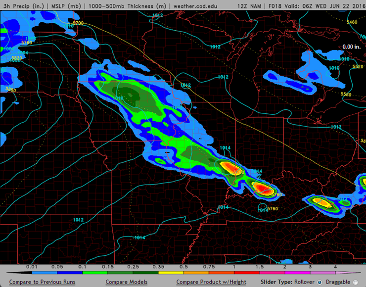
This next image shows you the NAM model guidance from 3/4 a.m. until 7 a.m. Again, maybe a few showers and storms over our northeast counties. But, I believe the better coverage will mainly be to our north and east.

Wednesday we will find ourselves in the warm sector of a significant storm system. The system on Wednesday will produce a lot of severe weather to our north and east. Mainly across northern Illinois and Wisconsin into Michigan and Indiana. Our region will find itself under hot and humid conditions with gusty southerly winds. Winds on Wednesday could gust into the 20-30 mph range from time to time. Air temperatures will rise well into the 90’s. And, heat index values will top 100 degrees. Not a pleasant day.
There will be a slight chance for a thunderstorm on Wednesday afternoon and evening. I suspect most of us will remain dry. A line of storms may approach southeast Illinois and northwest Kentucky on Wednesday night. Perhaps east of Mt Vernon and then into the Evansville area. Low confidence on that happening. The bulk of the storms may remain to our north and east.
Here is the future-cast three hour rainfall totals for Wednesday evening between 7 pm and 10 pm. Check out the big storms well to our north and east. Notice there isn’t anything in our region.

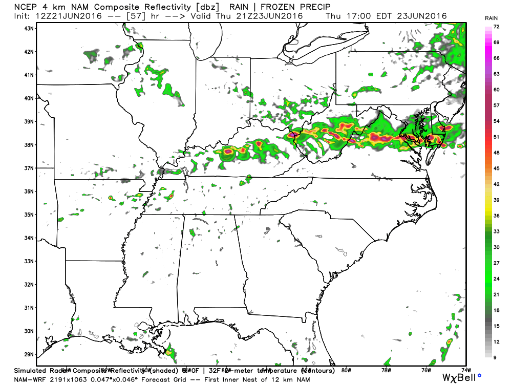
The warm front will return as a cold front on Thursday. Scattered showers and thunderstorms will be possible on Thursday and Thursday evening over our region. A few heavy downpours will be possible. And, a couple of strong storms can’t be ruled out. Storms, if they do develop on Thursday, could produce gusty winds and even a few reports of hail. Frequent cloud to ground lightning will also be a concern. Heavy downpours.
Here is the 4 KM NAM model guidance for Thursday morning and afternoon. This is the future-cast radar. What radar MIGHT look like. Never is exact when it comes to models. But, you get the general idea. A few storms will be possible on Thursday as a cold front moves into the region.
This first image is for 7 am on Thursday morning. You can see a few showers/storms dotting the region.

and for Thursday afternoon
Here are the three hour rainfall totals from 7 pm Thursday evening through 10 pm Thursday evening. We could have storms on Thursday and Thursday night. Locally heavy storms.

Friday into the weekend will be hot and muggy. Daily high temperatures into the 90’s with heat index values topping 100 degrees. Ick weather (in my opinion). There will be a daily chance for a few scattered thunderstorms. Many will remain dry. If storms do form then they could produce gusty winds, heavy downpours, lightning, and small hail.
Another cold front may enter our region on Monday. This would again be the focus of showers and thunderstorms. Low confidence on the Monday forecast.
Extended forecast: Heat or cooler?
There are quite a few questions concerning the Tuesday into Thursday forecast for next week. There are indications that a trough will develop over the Ohio Valley. A trough is when the jet stream dips southward into our region. If that happens then we will return to northwest flow (winds will turn out of the north). That could mean slightly cooler temperatures and perhaps some showers and storms. But, guidance is not in agreement on this topic. I lowered temperatures a little bit for the middle of next week. I will be monitoring trends.
Typically northwest flow means thunderstorm chances during the summer months.
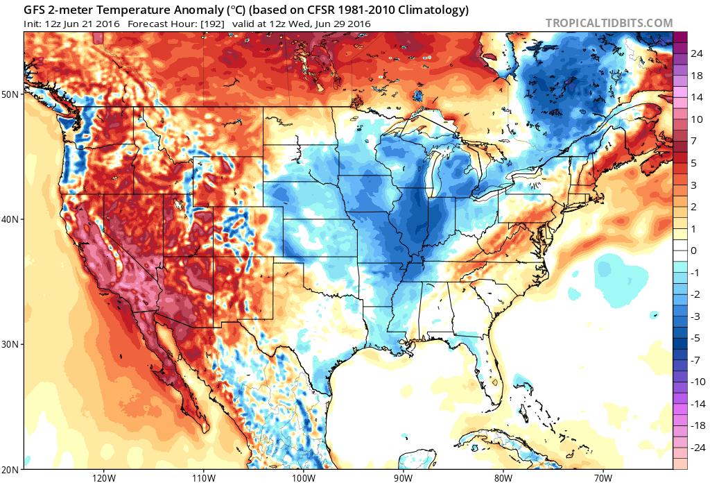
Let me show you the current temperature anomaly map. This is for Thursday, actually. How many degrees above or below normal will temperatures be? Red would be above normal. Blue would be below normal. As you can see, we will definitely have above normal temperatures on Wednesday. Thursday, Friday, and Saturday.
Normal high temperatures are around 87 degrees. Normal low temperatures are around 66 degrees.

But, look what the GFS does next week. Hmm It shows below normal temperatures. The GFS has been doing this for several weeks. Will this one verify? We shall see. This map is for next Wednesday.
Drought update:
I wanted to talk about our current soil moisture conditions. We have experienced a wet late winter and spring. But, over the last two weeks, we have started to become a bit dry. At least some counties (not all). Rainfall totals since the first of the month have ranged from less than a quarter of an inch to over four inches. Location, location, location. Typical for the summer months of June through August. It seems feast or famine normally is the general rule.
Let’s take a look at some maps that show meteorologists whether drought is a concern (or if we are too wet).
One problem, during the summer months, is that rainfall totals can vary GREATLY from county to county. I have witnessed counties pick up 4-8″ of rain in a couple of hours. Meanwhile, in the neighboring county, they only pick up a trace of rain. That is the problem during the summer. What is important is that you receive some rain over a period of time. Typically, not everyone will receive a general rainfall during June and July. Not unless an MCS moves over your area. MCS’s are large thunderstorm complexes that form in the afternoon and overnight hours. Or, if a tropical system impacts the region.
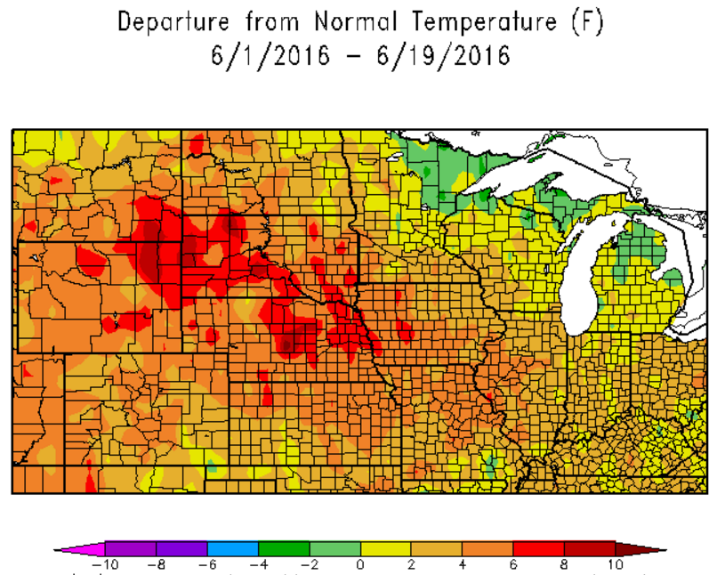
This first map shows you the temperature departures since June 1st. Much of the nation has experienced above normal to much above normal temperatures. It has been a warm June for our region, thus far. And, it will continue.
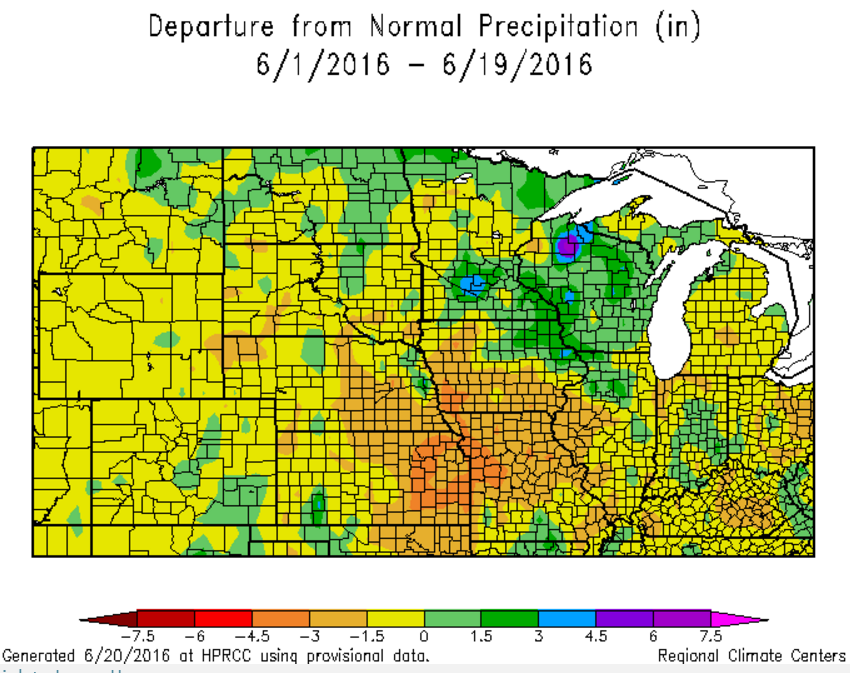
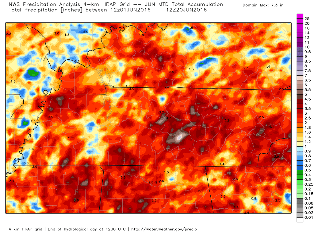
This next map shows you the month to date precipitation departure from normal. A large chunk of real estate has been drier than normal. Now, this does not count any rain that fell on Monday or Monday night/Tuesday morning. Keep that in mind. Also keep in mind that rain totals vary GREATLY from county to county during the summer months.
Notice that southeast Missouri is well below normal in the rainfall department. That would be the darker orange color. Check out western Kentucky. It is located in the green zone. That represents above normal rainfall (so far this month). Again, it can vary greatly from county to county.
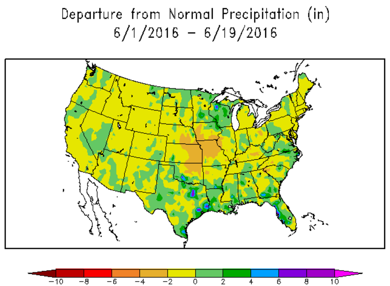
Here is the national view of the same map. A large chunk of real estate has been drier than normal since June 1st.
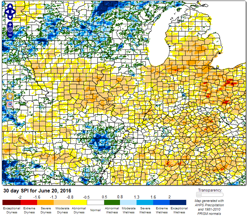
Let’s take a look at the SPI index. This graphic will show you whether the ground is wet or dry. You can see a mixed bag in our region. But, we are starting to dry out. Especially with all the recent 90+ temperature readings. It does not take long to dry out with high temperatures. Keep this in mind.
The Standardized Precipitation Index (SPI) is a precipitation-based, multi-scalar drought index that represents the amount of precipitation for a given period in terms of its historical distribution. Positive SPI values represent greater than median precipitation, negative SPI values represent less than median precipitation, and values between 0.5 and -0.5 indicate neutral, or near normal, moisture conditions.
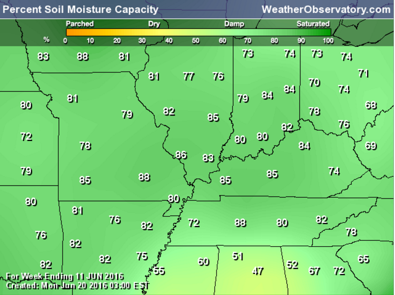
You can click the graphics to make them larger. This next graphic shows you the percent of soil moisture capacity. We could use a little bit of rain (parts of the region). We are averaging around 80-85%. That is the lower to middle damp range.
Soil moisture anomalies. You can see parts of the region are dry. We could use a general rain.

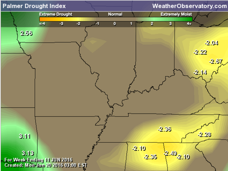
Palmer drought index indicates we are not having drought problems, yet.
The graphic below shows you how much rain is needed to bring deficits up to normal. The graphic says to end drought. But, it is more about long term deficits vs short term.

The graphics below are from weatherbell.com They are a little hard to read. I have zoomed in on southern Illinois, southeast Missouri, Kentucky, and Tennessee. The scale is on the right side of the page and it is in inches. These maps show you how much rain has fallen over a certain period of time. Click the graphics to make them larger.
The graphic below shows you how much rain has fallen over the past 7 days. This is through MONDAY (not Tuesday).

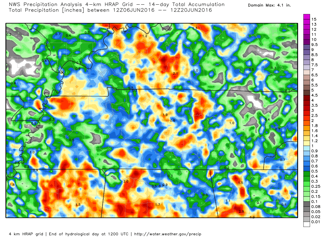
The graphic below shows you how much rain has fallen over the past 14 days.
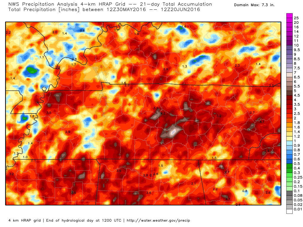
The graphic below shows you how much rain has fallen over the past 21 days.
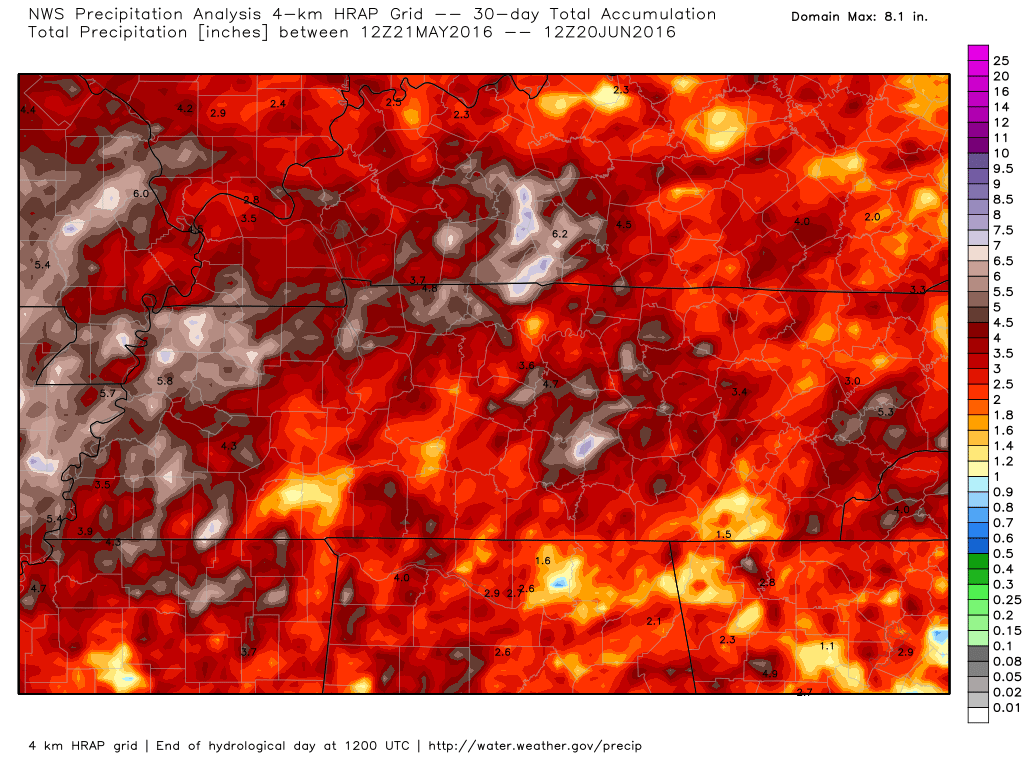
The graphic below shows you how much rain has fallen over the last 30 days.
This is how much rain has fallen since June 1st.
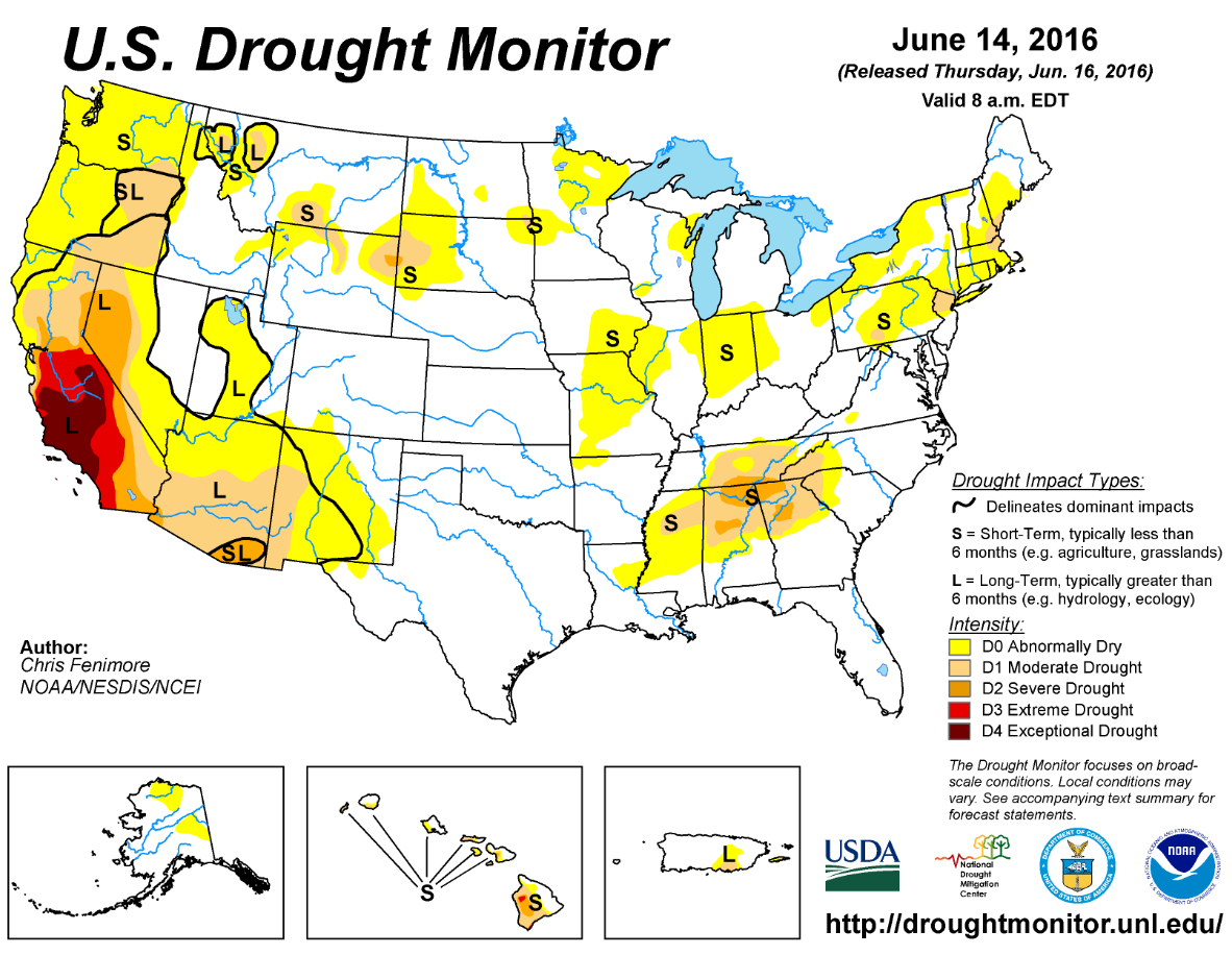
Here is the official government drought monitor map. Areas in yellow are drier than normal. Areas in dark tan color and orange are in drought conditions. Our region is in the neutral zone. This map will be updated on Thursday.


We have regional radars and local city radars – if a radar does not seem to be updating then try another one. Occasional browsers need their cache cleared. You may also try restarting your browser. That usually fixes the problem. Occasionally we do have a radar go down. That is why I have duplicates. Thus, if one fails then try another one.
If you have any problems then please send me an email beaudodson@usawx.com
WEATHER RADAR PAGE – Click here —
We also have a new national interactive radar – you can view that radar by clicking here.
Local interactive city radars include St Louis, Mt Vernon, Evansville, Poplar Bluff, Cape Girardeau, Marion, Paducah, Hopkinsville, Memphis, Nashville, Dyersburg, and all of eastern Kentucky – these are interactive radars. Local city radars – click here

Live Lightning Data – zoom and pan: Click here
Live Lightning Data with sound (click the sound button on the left side of the page): Click here

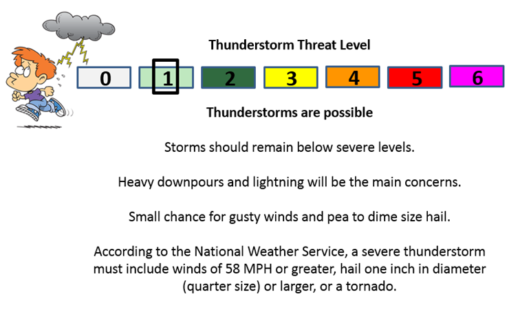
Can we expect severe thunderstorms over the next 24 to 48 hours? Remember that a severe thunderstorm is defined as a thunderstorm that produces 58 mph winds or higher, quarter size hail or larger, and/or a tornado.
.
Tuesday night: A couple of thunderstorms will be possible. Lightning is the main concern. Heavy downpours is a second concern. The risk for severe weather is small. If storms form late tonight (ahead of the warm front) then they could also produce hail. Better chances well to our north and east.
A level one risk for Tuesday night and again on Thursday. Monitor updates. A few storms could produce hail and strong winds.
Wednesday: Isolated storm possible. Believe the majority of the region will remain dry. If a storm were to form then it would be intense. Low chance.
Thursday: Thunderstorms possible. A few storms could produce strong winds, heavy rain, and frequent lightning. Dime to nickle size hail, as well.
.

.
Made small adjustments to temperatures, wind, and precipitation probabilities. Tough forecast for the coming seven to ten days. Monitor updates frequently..
.

.
A couple of concerns over the coming seven to ten days.
- The heat. Heat index values, when thunderstorms and clouds are not present, will range from 95-105 degrees.
- Locally heavy thunderstorms will be in the forecast for Tuesday into Wednesday morning. A few storms could produce strong winds, nickel size hail, and frequent lightning, Heavy rain totals in isolated spots could top 1-3″.
- Storms are again possible on Thursday. Locally strong storms can’t be ruled out.
.

.
The next seven to ten days will deliver plenty of hot and humid days. That means to refresh the water bowls for our outdoor friends. Keep in mind that children, elderly people, and pets can quickly overheat in parked vehicles. It is common for temperatures to exceed 150 degrees inside an enclosed vehicle. Dangerous levels, obviously. Use common sense, as always.
On and off thunderstorm chances into the weekend. Scattered. Thus, having an umbrella handy is a good idea. Lightning will be the main concern for those of you outdoors. Gusty winds in a few storms, as well.
.

How much precipitation should we expect over the next few days?
We will have on and off thunderstorm chances over the coming days. Rainfall totals will range from 0.00″ to 1-3″. WIDE range of totals. Typical for summer months with thunderstorms. Most of you know this. Not everyone will receive measurable rain. And, some will receive a months worth of rain in a short period of time.

Here are the current river stage forecasts. You can click your state and then the dot for your location. It will bring up the full forecast and hydrograph.
..

Here is the official 6-10 day and 8-14 day temperature and precipitation outlook. Check the date stamp at the top of each image (so you understand the time frame).
The forecast maps below are issued by the Weather Prediction Center (NOAA).


The latest 8-14 day temperature and precipitation outlook. Note the dates are at the top of the image. These maps DO NOT tell you how high or low temperatures or precipitation will be. They simply give you the probability as to whether temperatures or precipitation will be above or below normal.


Who do you trust for your weather information and who holds them accountable?
I have studied weather in our region since the late 1970’s. I have 37 years of experience in observing our regions weather patterns. My degree is in Broadcast Meteorology from Mississippi State University and an Associate of Science (AS). I am currently working on my Bachelor’s Degree in Geoscience.
My resume includes:
Member of the American Meteorological Society.
NOAA Weather-Ready Nation Ambassador.
Meteorologist for McCracken County Emergency Management. I served from 2005 through 2015.
I own and operate the Southern Illinois Weather Observatory.
Recipient of the Mark Trail Award, WPSD Six Who Make A Difference Award, Kentucky Colonel, and the Caesar J. Fiamma” Award from the American Red Cross.
In 2009 I was presented with the Kentucky Office of Highway Safety Award.
Recognized by the Kentucky House of Representatives for my service to the State of Kentucky leading up to several winter storms and severe weather outbreaks.
I am also President of the Shadow Angel Foundation which serves portions of western Kentucky and southern Illinois.
There is a lot of noise on the internet. A lot of weather maps are posted without explanation. Over time you should learn who to trust for your weather information.
My forecast philosophy is simple and straight forward.
- Communicate in simple terms
- To be as accurate as possible within a reasonable time frame before an event
- Interact with you on Twitter, Facebook, and the blog
- Minimize the “hype” that you might see on television or through other weather sources
- Push you towards utilizing wall-to-wall LOCAL TV coverage during severe weather events
I am a recipient of the Mark Trail Award, WPSD Six Who Make A Difference Award, Kentucky Colonel, and the Caesar J. Fiamma” Award from the American Red Cross. In 2009 I was presented with the Kentucky Office of Highway Safety Award. I was recognized by the Kentucky House of Representatives for my service to the State of Kentucky leading up to several winter storms and severe weather outbreaks.
If you click on the image below you can read the Kentucky House of Representatives Resolution.

Many of my graphics are from www.weatherbell.com – a great resource for weather data, model data, and more


You can sign up for my AWARE email by clicking here I typically send out AWARE emails before severe weather, winter storms, or other active weather situations. I do not email watches or warnings. The emails are a basic “heads up” concerning incoming weather conditions.