We have some great sponsors for the Weather Talk Blog. Please let our sponsors know that you appreciate their support for the Weather Talk Blog.
Milner and Orr Funeral Home and Cremation Services located in Paducah, Kentucky and three other western Kentucky towns – at Milner and Orr they believe in families helping families. You can find Milner and Orr on Facebook, as well.
![]()
.

For all of your families eye care needs. Visit their web-site here. Or, you can also visit their Facebook page.
.

Best at Enabling Body Shop Profitability since 1996. Located In Paducah Kentucky and Evansville Indiana; serving all customers in between. They provide Customer Service, along with all the tools necessary for body shops to remain educated and competitive. Click the logo above for their main web-site. You can find McClintock Preferred Finishes on Facebook, as well

Expressway Carwash and Express Lube are a locally owned and operated full service Carwash and Lube established in 1987. They have been proudly serving the community for 29 years now at their Park Avenue location and 20 years at their Southside location. They have been lucky enough to partner with Sidecar Deli in 2015, which allows them to provide their customers with not only quality service, but quality food as well. . If you haven’t already, be sure to make Expressway your one stop shop, with their carwash, lube and deli. For hours of operation and pricing visit www.expresswashlube.com or Expressway Carwash on Facebook.

TORNADO SHELTERS! Endrizzi’s Storm Shelters – For more information click here. Endrizzi Contracting and Landscaping can be found on Facebook, as well – click here
I have launched the new weather texting service! I could use your help. Be sure and sign up and fully support all of the weather data you see each day.
This is a monthly subscription service. Supporting this helps support everything else. The cost is $3 a month for one phone, $5 a month for three phones, and $10 a month for seven phones.
For more information visit BeauDodsonWeather.com
Or directly sign up at Weathertalk.com


This forecast update covers far southern Illinois, far southeast Missouri, and far western Kentucky. See the coverage map on the right side of the blog.
Remember that weather evolves. Check back frequently for updates, especially during active weather.

Rest of Sunday: Partly cloudy. A scattered shower or thunderstorm possible. High temperature from 88-92 degrees. It will feel more humid today. South winds at 5-10 mph.
Sunday Night – Mostly clear o partly cloudy. Mild evening. An isolated thunderstorm possible.
What impact is expected? Lightning and wet roadways.
Temperatures: Lows in the 68-74 degree range
Winds: Winds south and southwest at 5-10 mph.
What is the chance for precipitation? 10%
Coverage of precipitation: Isolated
Is severe weather expected? No
My confidence in this part of the forecast verifying is High
Should I cancel my outdoor plans? No
.
Monday – Partly to mostly sunny. Hot. Humid. A chance for a couple of thunderstorms in the region.
What impact is expected? Heat index values will be 95-100 degrees. Lightning and wet roadways possible in isolated areas.
Temperatures: High temperatures in the 90-95 degree range
Winds: South and southwest winds at 5-10 mph with gusts to 18 mph.
What is the chance for precipitation? 10%
Coverage of precipitation? Isolated
Is severe weather expected? No
My confidence in this part of the forecast verifying is High
Should I cancel my outdoor plans? No
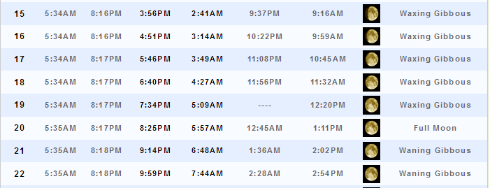
Sunrise will be at 5:35 a.m. and sunset will be at 8:17 p.m.
UV index will be 9-10. High.
Moonrise will be at 8:25 p.m. and moonset will be at 5:57 a.m. Full moon.
Monday Night – Partly cloudy. Warm. A bit more humid, as well. Thunderstorms becoming increasingly possible after midnight. A few isolated storms possible before midnight. Locally heavy downpours where storms occur.
What impact is expected? Lightning and wet roadways. Gusty winds near storms.
Temperatures: Lows in the 70-75 degree range
Winds: Winds southwest at 5 mph.
What is the chance for precipitation? 30% before midnight. And, 50%-60% after midnight.
Coverage of precipitation: Becoming scattered with increasing coverage potential late at night.
Is severe weather expected? No
My confidence in this part of the forecast verifying is High
Should I cancel my outdoor plans? No
.
Tuesday – Partly to mostly sunny. Hot. More humid. Thunderstorms possible. A cold front approaches from the north on Tuesday or Wednesday. Some storms could be heavy with frequent lightning and heavy rain.
What impact is expected? Lightning, heavy downpours, gusty winds will be possible.
Temperatures: High temperatures in the 86-94 degree range
Winds: South and southwest winds at 5-10 mph with gusts to 18 mph.
What is the chance for precipitation? 50%-60%
Coverage of precipitation? Scattered to perhaps numerous
Is severe weather expected? A few storms could be intense. Isolated severe thunderstorm risk.
My confidence in this part of the forecast verifying is High
Should I cancel my outdoor plans? No, but monitor radars. Storms are possible. And, this could disrupt outdoor activities.
Sunrise will be at 5:35 a.m. and sunset will be at 8:18 p.m.
UV index will be 8-9. High.
Moonrise will be at 9:14 p.m. and moonset will be at 6:48 a.m. Waning Gibbous.
Tuesday Night – Partly cloudy. Warm. More humid. A thunderstorm possible.
What impact is expected? Lightning, heavy downpours, and gusty winds. Wet roadways.
Temperatures: Lows in the 72-76 degree range
Winds: Winds variable at 5-10 mph.
What is the chance for precipitation? 50%-60%
Coverage of precipitation: Scattered to perhaps numerous
Is severe weather expected? Isolated severe weather risk. Damaging wind would be the main concern.
My confidence in this part of the forecast verifying is High
Should I cancel my outdoor plans? No, but monitor radars. Storms are possible. And, this could disrupt outdoor activities.
.
Wednesday – Partly to mostly sunny. Hot and humid. Thunderstorms again possible. Especially before 11 a.m. A cold front will be near our region on Wednesday.
What impact is expected? Wet roadways and lightning. Locally heavy rain.
Temperatures: High temperatures in the 86-92 degree range
Winds: South and west winds at 5-10 mph with gusts to 15 mph
What is the chance for precipitation? 40%-50% before 12 p.m. and 20% after 12 p.m.
Coverage of precipitation? Scattered to perhaps numerous
Is severe weather expected? Most likely no. But, monitor updates.
My confidence in this part of the forecast verifying is High
Should I cancel my outdoor plans? No, but a few storms are possible. Especially true for the morning hours.
Sunrise will be at 5:35 a.m. and sunset will be at 8:18 p.m.
UV index will be 8-9. Very high.
Moonrise will be at 9:59 p.m. and moonset will be at 7:44 a.m. Waning Gibbous.
Wednesday Night – Partly cloudy. An isolated to scattered thunderstorm possible.
What impact is expected? Wet roadways and lightning. Heavy downpours where storms occur.
Temperatures: Lows in the 68-74 degree range
Winds: Winds southwest at 5-10 mph. Winds becoming variable.
What is the chance for precipitation? 30%
Coverage of precipitation: Isolated to scattered
Is severe weather expected? Most likely no
My confidence in this part of the forecast verifying is Low
Should I cancel my outdoor plans? No
.
Low confidence in the forecast from Thursday onward.
Thursday – Partly to mostly sunny. Warm. A thunderstorm possible. Perhaps less humid.
What impact is expected? Wet roadways and lightning. Gusty winds in storms. Small hail possible, as well.
Temperatures: High temperatures in the 88-94 degree range
Winds: Variable winds at 5-10 mph
What is the chance for precipitation? 20%-30%
Coverage of precipitation? Isolated to perhaps scattered
Is severe weather expected? Monitor updates.
My confidence in this part of the forecast verifying is Low
Should I cancel my outdoor plans? No, but monitor radars. A front may return to the region on Thursday.
Sunrise will be at 5:35 a.m. and sunset will be at 8:18 p.m.
UV index will be 8-9. Very high.
Moonrise will be at 10:41 p.m. and moonset will be at 8:43 a.m. Waning Gibbous.
Thursday Night – Mostly clear. A thunderstorm possible.
What impact is expected? Lightning, heavy downpours, gusty winds.
Temperatures: Lows in the 68-74 degree range
Winds: Winds west and northwest at 4-8 mph.
What is the chance for precipitation? 20%-30%
Coverage of precipitation: Isolated
Is severe weather expected? No, but I would suggest monitoring updated information.
My confidence in this part of the forecast verifying is Low
Should I cancel my outdoor plans? No, but monitor radars.
.
Friday – Partly to mostly sunny. Warm. Low confidence on storms Friday into the weekend.
What impact is expected?
Temperatures: High temperatures in the 86-92 degree range
Winds: Variable winds at 5-10 mph
What is the chance for precipitation? 20%
Coverage of precipitation?
Is severe weather expected?
My confidence in this part of the forecast verifying is Low
Should I cancel my outdoor plans? No
Sunrise will be at 5:36 a.m. and sunset will be at 8:18 p.m.
UV index will be 8-9. Very high.
Moonrise will be at 11:21 p.m. and moonset will be at 9:45 a.m. Waning Gibbous.
Friday Night – Partly cloudy. A thunderstorm possible.
What impact is expected?
Temperatures: Lows in the 65-70 degree range
Winds: Winds west at 5-10 mph.
What is the chance for precipitation? 10%-20%
Coverage of precipitation:
Is severe weather expected?
My confidence in this part of the forecast verifying is Low
Should I cancel my outdoor plans? No
.
Saturday – Partly to mostly sunny. Hot. Low confidence on Saturday and Sunday’s forecast. Maybe a few storms.
What impact is expected?
Temperatures: High temperatures in the 86-94 degree range
Winds: Variable winds at 5-10 mph
What is the chance for precipitation? 10%-20%
Coverage of precipitation?
Is severe weather expected?
My confidence in this part of the forecast verifying is Low
Should I cancel my outdoor plans?
Sunrise will be at 5:36 a.m. and sunset will be at 8:18 p.m.
UV index will be 8-9. Very high.
Moonrise will be at 11:59 p.m. and moonset will be at 10:48 a.m. Waning Gibbous.
Saturday Night – Partly cloudy.
What impact is expected?
Temperatures: Lows in the 68-74 degree range
Winds: Winds west at 5-10 mph.
What is the chance for precipitation? 10%
Coverage of precipitation:
Is severe weather expected?
My confidence in this part of the forecast verifying is Low
Should I cancel my outdoor plans? No
.
Sunday – Partly to mostly sunny. Hot.
What impact is expected?
Temperatures: High temperatures in the 86-94 degree range
Winds: Variable winds at 5-10 mph
What is the chance for precipitation? 10%-20%
Coverage of precipitation?
Is severe weather expected?
My confidence in this part of the forecast verifying is Low
Should I cancel my outdoor plans?
Sunrise will be at 5:36 a.m. and sunset will be at 8:18 p.m.
UV index will be 8-9. Very high.
Moonrise will be at -:– p.m. and moonset will be at 11:52 a.m. Waning Gibbous.
Sunday Night – Mostly clear.
What impact is expected?
Temperatures: Lows in the 68-74 degree range
Winds: Winds west at 5-10 mph.
What is the chance for precipitation? 10%-20%
Coverage of precipitation:
Is severe weather expected?
My confidence in this part of the forecast verifying is Low
Should I cancel my outdoor plans? No
.
Monday – Partly to mostly sunny. Hot.
What impact is expected?
Temperatures: High temperatures in the 88-94 degree range
Winds: Variable winds at 5-10 mph
What is the chance for precipitation? 10%-20%
Coverage of precipitation?
Is severe weather expected?
My confidence in this part of the forecast verifying is Low
Should I cancel my outdoor plans?
Sunrise will be at 5:36 a.m. and sunset will be at 8:18 p.m.
UV index will be 8-9. Very high.
Moonrise will be at 12:35 a.m. and moonset will be at 12:57 a.m. Last Quarter.
Monday Night – Partly cloudy.
What impact is expected?
Temperatures: Lows in the 68-74 degree range
Winds: Winds west at 5-10 mph.
What is the chance for precipitation? 10%
Coverage of precipitation:
Is severe weather expected?
My confidence in this part of the forecast verifying is Low
Should I cancel my outdoor plans? No
.
Tuesday – Partly to mostly sunny. Warm.
What impact is expected?
Temperatures: High temperatures in the 86-94 degree range
Winds: Variable winds at 5-10 mph
What is the chance for precipitation? 10%
Coverage of precipitation?
Is severe weather expected?
My confidence in this part of the forecast verifying is Low
Should I cancel my outdoor plans?
Sunrise will be at 5:36 a.m. and sunset will be at 8:18 p.m.
UV index will be 8-9. Very high.
Moonrise will be at 1:12 a.m. and moonset will be at 2:04 p.m. Waning Crescent.
Tuesday Night – Mostly clear.
What impact is expected?
Temperatures: Lows in the 65-70 degree range
Winds: Winds west at 5-10 mph.
What is the chance for precipitation? 10%
Coverage of precipitation:
Is severe weather expected?
My confidence in this part of the forecast verifying is Low
Should I cancel my outdoor plans?
.
More information on the UV index. Click here.
The weekend forecast is sponsored by Farmer and Company Real Estate.

Farmer & Company Real Estate is proud to represent buyers and sellers in both Southern Illinois and Western Kentucky. With 13 licensed brokers, we can provide years of experience to buyers & sellers of homes, land & farms and commercial & investment properties. We look forward to representing YOU! Follow us on Facebook, as well
The weekend forecast is sponsored by Farmer and Company Real Estate. Click here to visit their site.


Don’t forget to check out the Southern Illinois Weather Observatory web-site for weather maps, tower cams, scanner feeds, radars, and much more! Click here

An explanation of what is happening in the atmosphere over the coming days…
- Heating up. More humid. Dew points are on the rise!
- Cold front arrives on Tuesday and Wednesday.
- Locally heavy thunderstorm possible this week.
- Heat ridge builds back into the region?
Well, the weekend wasn’t too bad. Friday and Saturday were beautiful weather days. Especially true for June. A few showers did form on Saturday night. Mostly over western Kentucky. I had to come back and add rain chances late on Saturday to cover that. Had hoped the weekend would be completely dry. The winds turned around to the south and a weak disturbance was responsible for the light showers and isolated thundershowers. Some of you did pick up a quick 0.10″-0.25″ of rain.
We have an unsettled weather pattern developing for the week ahead. And, hotter temperatures. And, more humid. And, SUMMER!
Monday will deliver higher dew points. That means heat index values will approach 100 degrees. Actual air temperatures will range from 90-95 degrees. But, when you combine that with high dew points (moisture in the air) then you end up with uncomfortable conditions. Keep that in mind if you have to work outside.
A cold front will nudge into the region on Monday night and Tuesday. Showers and thunderstorms will develop near the front. Especially true for the late overnight hours on Monday into Tuesday morning. There will be chances for showers and thunderstorms area-wide on both Tuesday and Wednesday. Some of the storms could produce locally heavy rain, frequent lightning, small hail, and damaging winds. The heaviest rain may end up over the northern half of southeast Missouri, southern Illinois, into northwest Kentucky.
Dew points will be on the rise over the coming days. Dew points in the 50’s and lower 60’s typically feel pretty good. Nice weather. But, when dew points rise into the middle 60’s and 70’s, it becomes uncomfortable. As Jim Rasor says, air you wear. Air you wear would be 70 degree dew points.
What are dew points? Well, another great question. A lot of people confuse humidity and dew points. I like to use dew points to measure moisture in the air. This is the better way, actually. To learn more about dew points…click here
Dew points will rise into the 70s on Monday, Tuesday, and Wednesday. And, they may stay there for awhile. A soupy air mass. Again, fuel for thunderstorms.
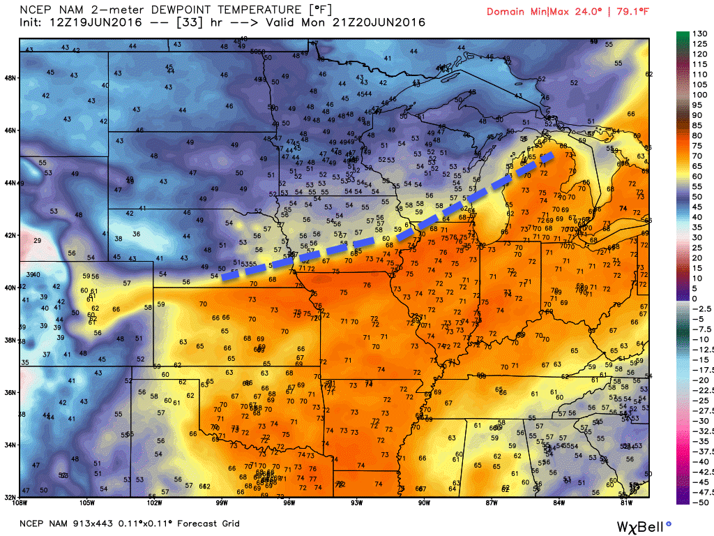
Here are some dew point forecast maps for the coming days. Watch the boundary to our north. I drew the boundary with a blue line.
The air is drier to the north of the blue line. Check out those dew points. Dew points in the 40’s across parts of Minnesota, Iowa, and Wisconsin. But, look at our area. Ick! Dew points well into the 70’s. Air you wear. Uncomfortable/sticky air. Maybe some of you like this weather? 🙂 I am sure you do! I guess it beats zero degrees with wind chills of -15 degrees.
This first dew point map is for Monday afternoon. Look at all the orange. That is humid air. High moisture content of that air.
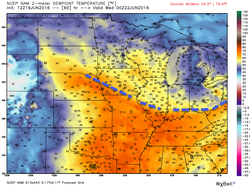
This map is for Tuesday evening. We are solidly in the orange. Air you wear. But, the boundary is close. Check out dew points across central Illinois and west central Indiana. They drop off fast behind the front.
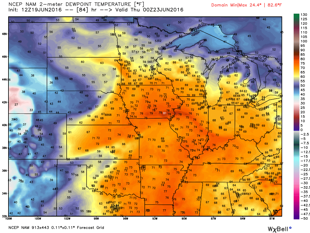
This map below is for Wednesday evening. Lot of moisture in the air. Notice how everything shifted back north? That is because the cold front is forecast to return northward as a warm front. That moves the high dew points further and further north. The boundary has moved into Wisconsin and Michigan.
What happens from Wednesday into Saturday?
Low confidence.
There are a lot of questions as to what happens in our region from Wednesday into Saturday. There are a few solutions to choose from. If the front stalls out near or south of our region then you can expect on and off heavy thunderstorms. But, if the front nudges back to the north then we will return to the heat and humidity.
A lot of guidance places the front north of our region on Wednesday into the weekend. That means the best rain chances would also shift to the north and east.
The best chances for showers and thunderstorms might end up over our northern and eastern counties from Wednesday onward. That would include areas like Mt Vernon, Illinois into the Princeton, Kentucky area. I have little confidence in the forecast from Wednesday onward. Keep that in mind. The exact placement of the boundary is key to our forecast.
For my detailed daily forecast I took the middle of the road approach. I did not place the temperatures quite as high as models are showing. A lot of data indicates 96-102 degrees possible Friday into next Monday. This is possible. Yes. But, I would rather ramp up rather than down. Meaning, I don’t want to put 100’s in the forecast this far out. And, it is also possible that the boundary will be near our region. If that occurs there will be a LARGE temperature difference from say Mt Vernon, Illinois to Poplar Bluff, Missouri. Behind the boundary temperatures could be in the lower to middle 80’s. Ahead of the boundary temperatures could be in the upper 90’s to lower 100’s. Again, placement of the boundary is key.
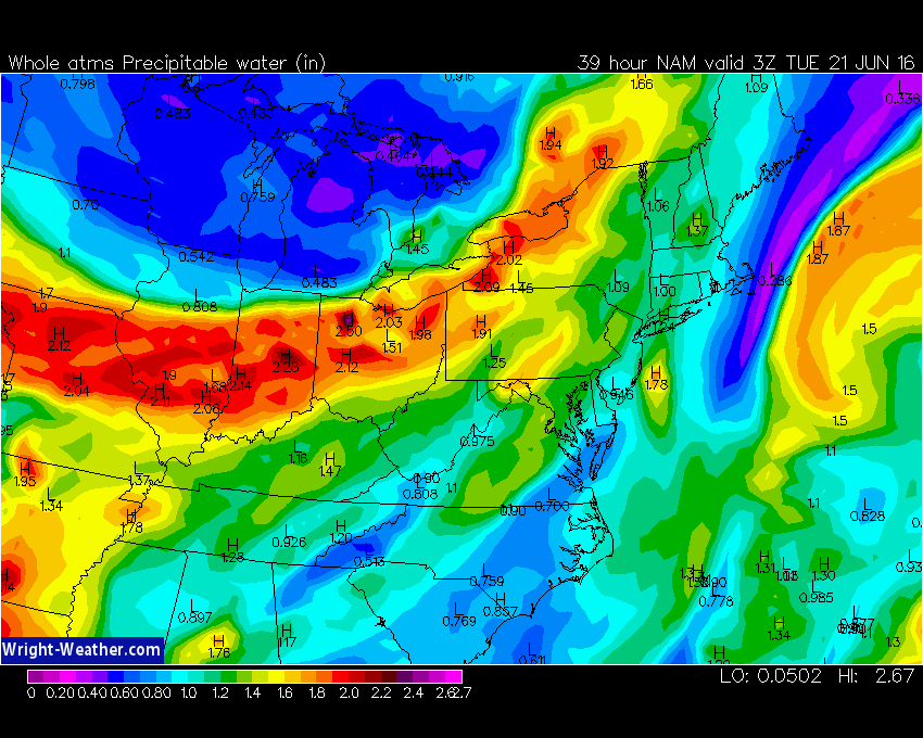
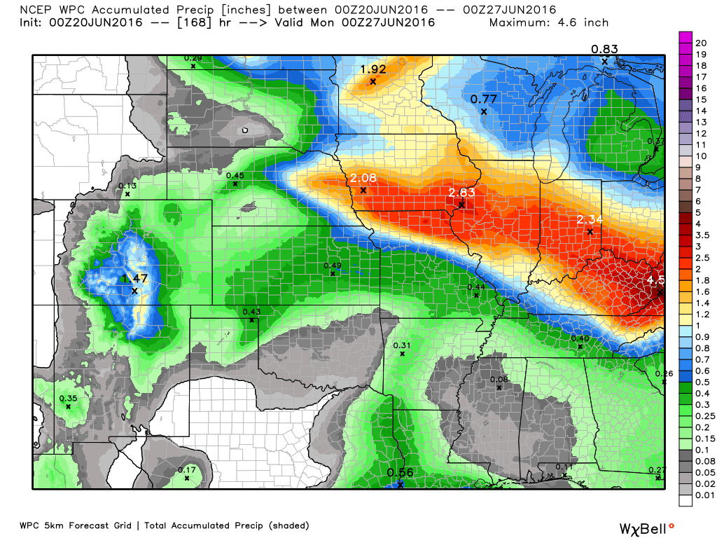
PWAT values will be high this week. Not surprised (it is summer). PWAT values are one way that meteorologists measure moisture in the atmosphere. Higher numbers indicate better chances for torrential downpours. When you start seeing 1.7″+ numbers then you can expect thunderstorms to produce very heavy downpours. Once again some 1-3″ per hour rainfall rates will be possible. Much like the last few weeks. Flash flooding will occur somewhere in the Missouri and Ohio Valleys. I would not be surprised if some places pick up more than five inches of rain between Monday and next Monday. But, whether that will be in our region is questionable. Someone will have a lot of rain this week.
Totals in our region will vary greatly. Typical for summer. Your neighbor can pick up an inch of rain and you end up with enough to dirty the car windshield.
Here are some weather maps
This first set of maps, from wright-weather, are the PWAT values. As you can see, there will be no shortage of moisture for storms to work with. This first map is for Tuesday afternoon. You can see widespread 1.8″ readings and higher. This is not a rainfall forecast map. Rather, these are PWAT values. If all the moisture were wrung out of the atmosphere from top to bottom. High numbers equal the risk for heavy thunderstorms. Slow moving storms would produce big rain totals. Notice the boundary between high numbers and lower numbers. Lower numbers are indicated by the light green and blue colors.
I will be watching that boundary. Often times you will see thunderstorm complexes ride the boundary. The boundary is slanted northwest to southeast. Many of the MCS’s will move towards the southeast. Riding the boundary. Typical behavior for large thunderstorm complexes.
What are PWAT values? Great question! I found this blog post that explains it quite well. Click here for more information on PWAT values.
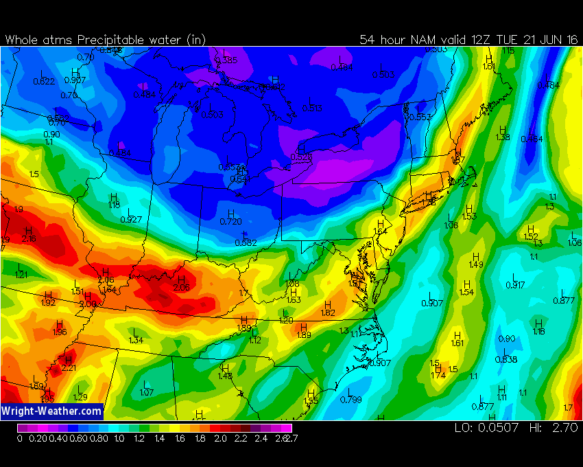
This first image is for Monday night around 10 pm. Notice the higher totals are to our north. The red indicates 2″+ PWAT values.
Watch how the boundary sags southward with time.
This next image is the PWAT value forecast for Tuesday morning at 7 am.
This next image is the PWAT value forecast for Tuesday evening. Lot of moisture in our region. If thunderstorms develop on Tuesday then they could produce heavy downpours.
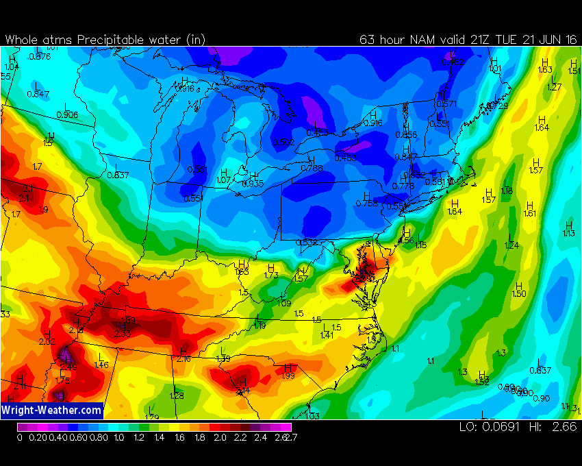
Wednesday could bring a severe weather event to our north. Perhaps centered on central and northern Illinois into Indiana. I would not be surprised if several reports of wind damage occur in those areas. And, tornadoes will also be possible. Whether our region ends up with a few severe thunderstorms on Wednesday is still questionable. But, worth monitoring.
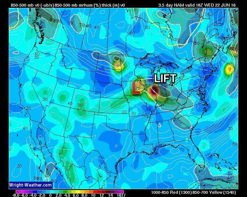
This next map shows you where lift is occurring. The bright colors represent greater lift. Notice how it is centered over northern Illinois. This is for Wednesday.
An area of low pressure will track across Iowa. Assuming that track occurs then we will be in the warm sector of the system. And, we could even be capped. If warm air aloft moves into the region then we will cap. Capped means that storms can’t form. Updrafts bump up against warm air aloft and then sink back to earth. Imagine a bouncing ball. Imagine a ceiling height of 4 feet high. The ball can’t bounce very high. In order for storms to form you need colder air aloft. Then the updraft can continue to expand and rise. Often times our region is capped during the summer months. Warm air aloft will kill air updrafts.
Let me show you the NAM future-cast radar model guidance. Now, this won’t be exact. But, it gives you some idea of placement of thunderstorm complexes. The thunderstorm complexes are called MCS’s. Large thunderstorm complexes that form during the overnight hours and track over quite a bit of real estate. You will see me mention MCS over the coming days.
What is a Mesoscale Convective System? Large thunderstorm complexes that form in the late spring and summer months. Here is a great educational lesson on this topic…click here
Perhaps the greatest risk for MCS’s will be to our north and east. But, that does not leave us in the clear. I suspect one or more MCS’s to move over our region on Tuesday and Wednesday. Again, some questions as to what happens after Wednesday.
The track of the MCS’s will be key to how much rain falls this week. If several MCS’s track over the same area then you can expect at least 1-3″ of rain in that zone. And, likely more than that for isolated areas.
Right now the BIG totals look to be centered from Iowa into northern and central Illinois and then into Indiana, Ohio, and central/eastern Kentucky. But, confidence is low on placement of the big totals. Any shift in the frontal boundary will change the forecast.
I would not be surprised to see some locations pick up one to three inches of rain in our region, as well. Again, same as the last few weeks. Some of you have picked up a LOT of rain since the first of the month. And, some of you have had very little rain.
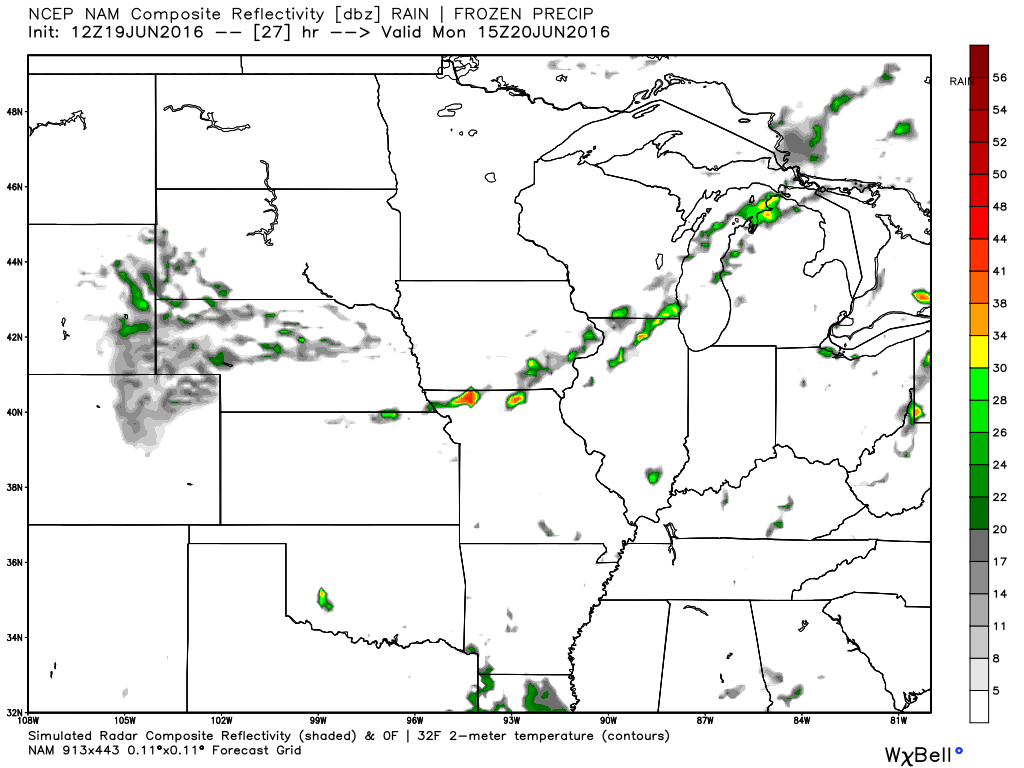
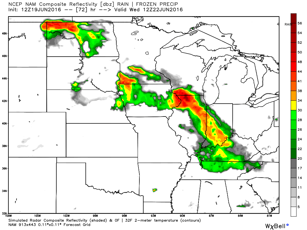
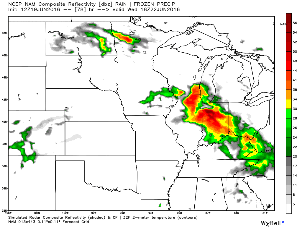
Future-cast NAM radar from weatherbell.com
This is what radar MIGHT look like. This is guidance and not gospel. Meaning, it won’t be exact. It is a model forecast.
This first image is for Monday morning. A couple of green dots over our region. Isolated thunderstorms.
This next image is for Tuesday morning around 3 or 4 a.m.
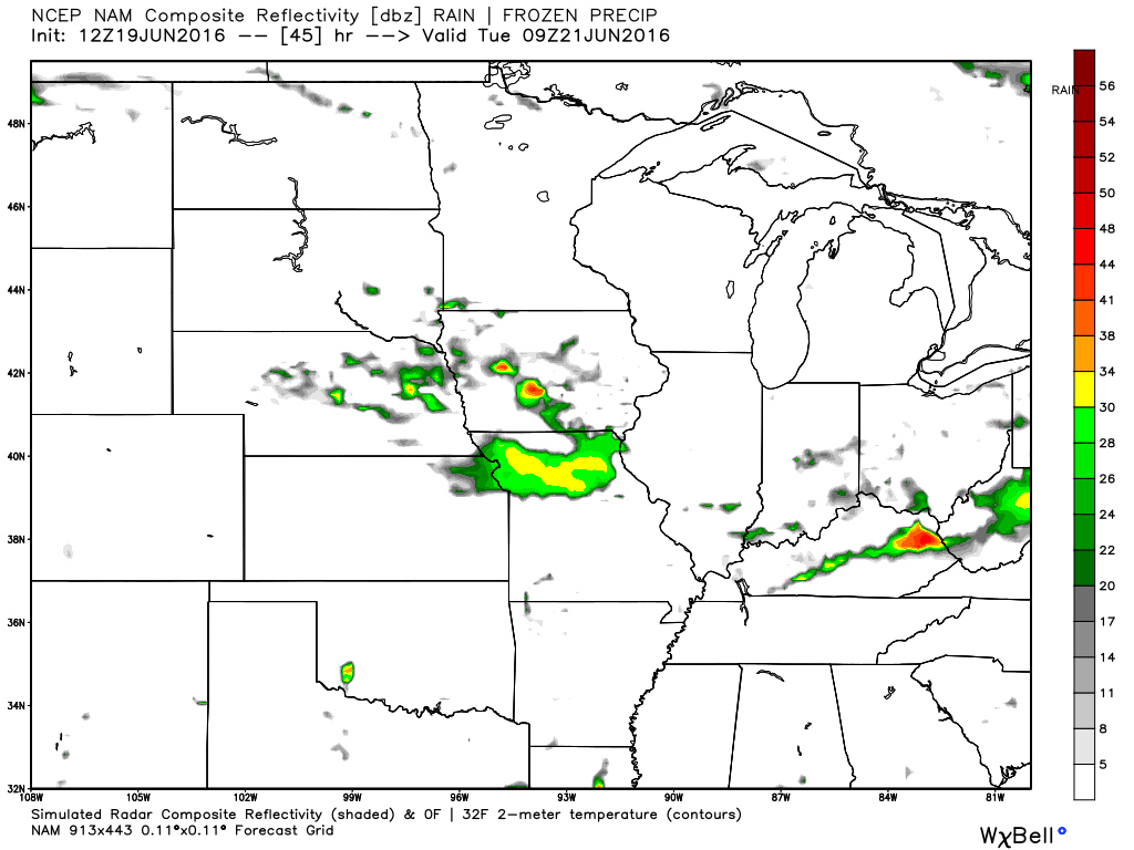
This next image is for Tuesday morning at 7 am. Showers and thunderstorms possible in our region. The colors represent rain and storms. The yellow, orange, and red colors represent heavier precipitation.
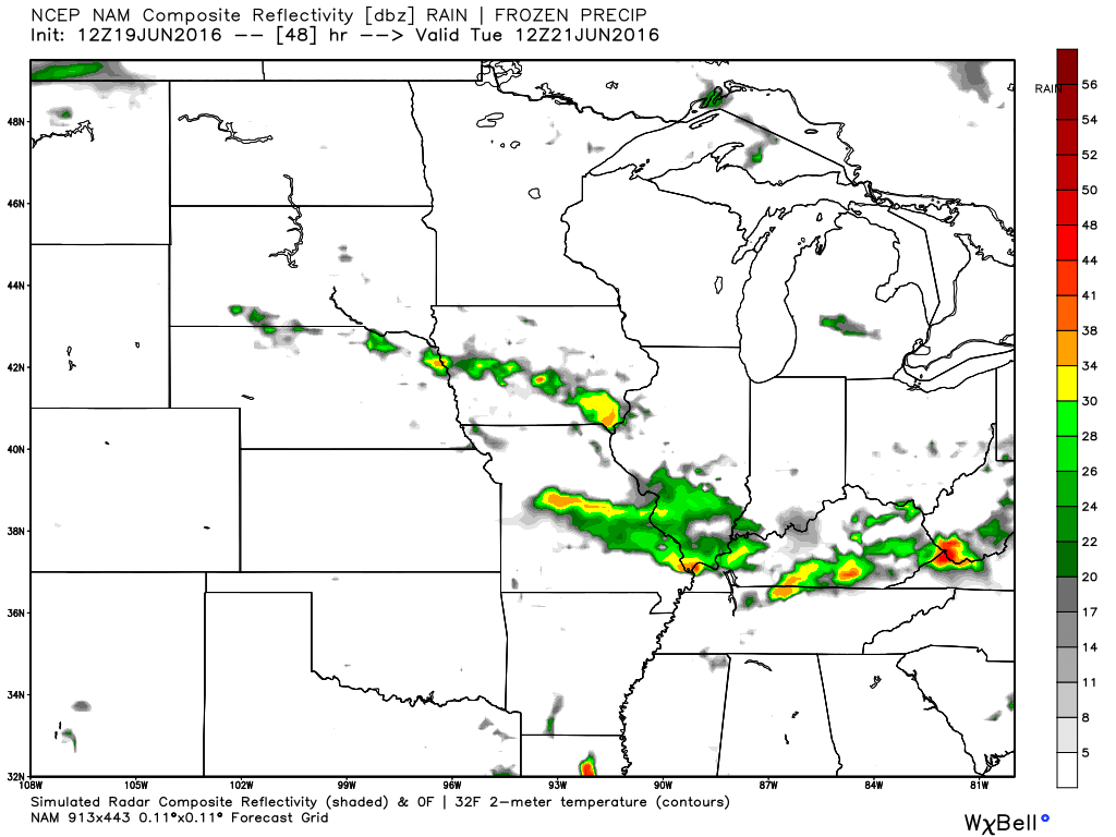
This next image is for Tuesday morning around 10 a.m.
This next image, below, is for Tuesday afternoon around 3 or 4 p.m.
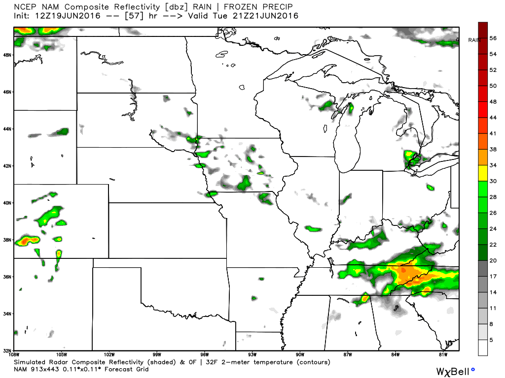
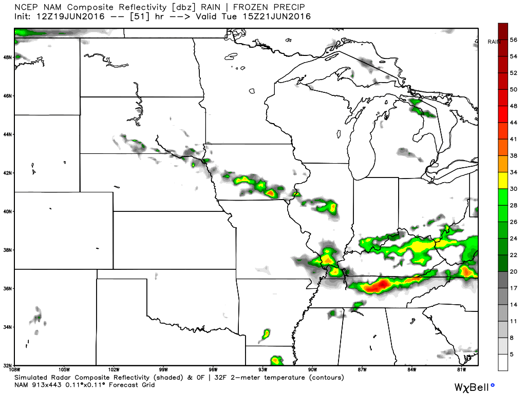
This next image is for Tuesday evening around 10 p.m.
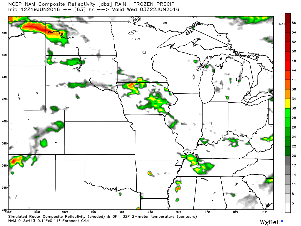
This image below is for Wednesday morning around 1 a.m.
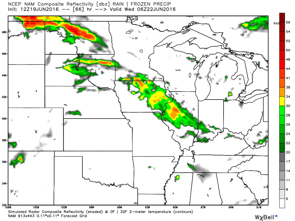
This next image is for Wednesday morning around 4 a.m. Notice how the main storm band has shifted north and east? This will need to be monitored. The front will stall out over our region on Tuesday night and Wednesday morning. Then, it should shift back north and east on Wednesday. That is the forecast, at least.
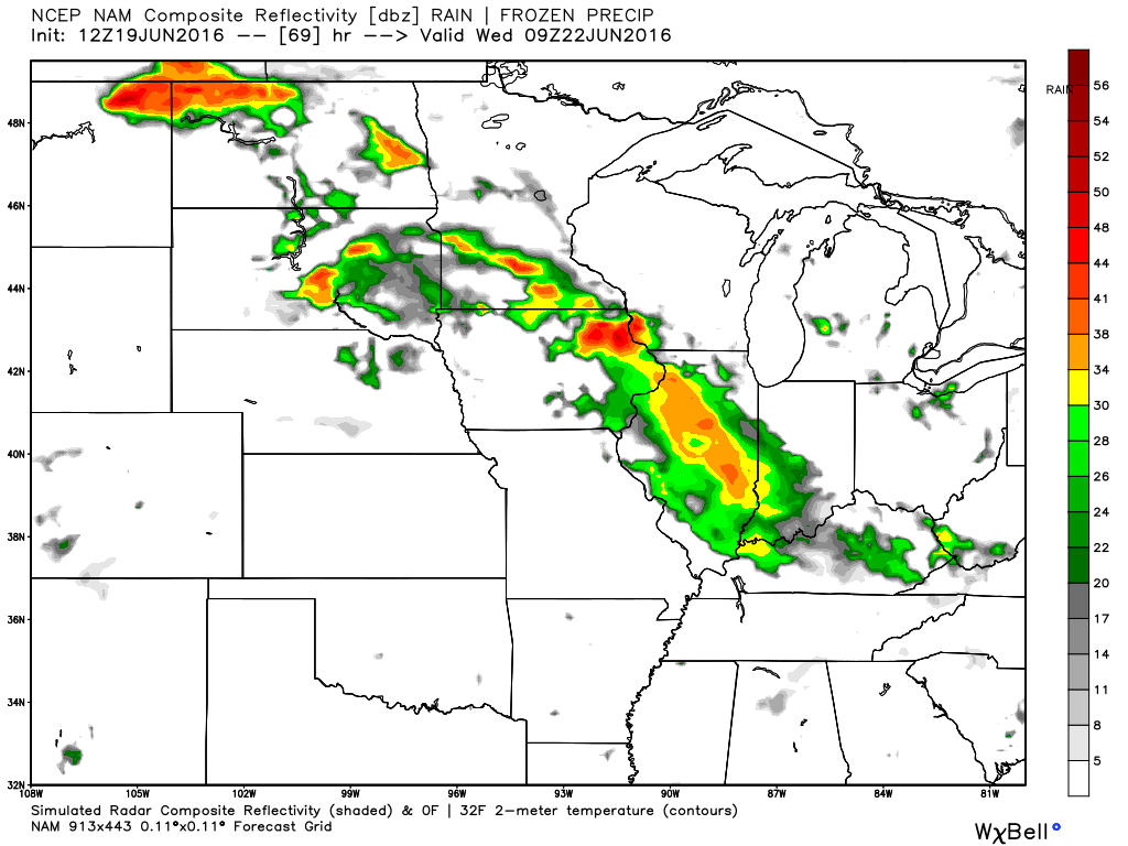
This next image is for Wednesday around 7 a.m.
This next image is for Wednesday afternoon around 1 p.m.
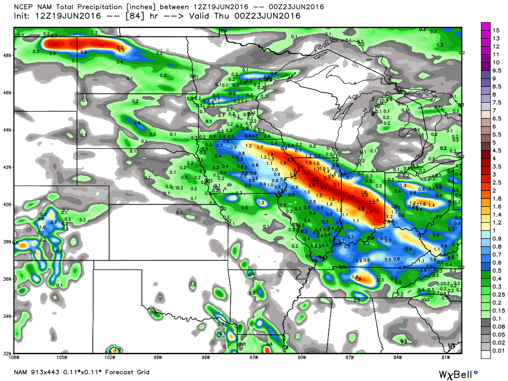
Here is the NAM rainfall total forecast. Notice that streak of red? Those are 1-3″+ rainfall totals. It is these bands that we will need to monitor this week. Again, the biggest totals may be to our north and east. But, questions remain on the eventual placement of the front boundary for Wednesday night into Friday. Placement is key to our weather.
These numbers are through Wednesday afternoon. Additional large thunderstorm complexes will form on Wednesday night into Friday. Perhaps to our north and east. This will need to be monitored. Placement of the front is key to our weather forecast.


We have regional radars and local city radars – if a radar does not seem to be updating then try another one. Occasional browsers need their cache cleared. You may also try restarting your browser. That usually fixes the problem. Occasionally we do have a radar go down. That is why I have duplicates. Thus, if one fails then try another one.
If you have any problems then please send me an email beaudodson@usawx.com
WEATHER RADAR PAGE – Click here —
We also have a new national interactive radar – you can view that radar by clicking here.
Local interactive city radars include St Louis, Mt Vernon, Evansville, Poplar Bluff, Cape Girardeau, Marion, Paducah, Hopkinsville, Memphis, Nashville, Dyersburg, and all of eastern Kentucky – these are interactive radars. Local city radars – click here

Live Lightning Data – zoom and pan: Click here
Live Lightning Data with sound (click the sound button on the left side of the page): Click here

Can we expect severe thunderstorms over the next 24 to 48 hours? Remember that a severe thunderstorm is defined as a thunderstorm that produces 58 mph winds or higher, quarter size hail or larger, and/or a tornado.
.
Sunday night: Small chance for a thunderstorm. A 10% risk at any given location.
Monday and Monday night: A couple of thunderstorms will be possible. Lightning is the main concern.
Then a level one risk for Tuesday and Wednesday. Monitor updates.
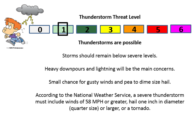
Tuesday into Wednesday: Thunderstorms possible. A few storms could produce strong winds, heavy rain, and frequent lightning. Dime size hail, as well.
Thursday into Friday: Low confidence. Monitor updates.
.

.
Updated temperatures, winds, and rain probabilities.
.

.
A couple of concerns over the coming days.
- The heat. Heat index values will creep back towards 100 degrees on Monday and Tuesday.
- Locally heavy thunderstorms will be in the forecast for at least Tuesday and Wednesday (small chances on Monday/Monday night, as well).
- Monitoring the heat ridge for later this week. If it nudges back into our region then temperatures will rise into the upper 90’s and lower 100’s.
.

.
You will want to drink plenty of fluids. Hot weather could cause problems for those working outside.
Make sure the outdoor pets have plenty of water.
I am monitoring increasing thunderstorm chances for Tuesday into the new work week.
.

How much precipitation should we expect over the next few days?

Here are the current river stage forecasts. You can click your state and then the dot for your location. It will bring up the full forecast and hydrograph.
..

Here is the official 6-10 day and 8-14 day temperature and precipitation outlook. Check the date stamp at the top of each image (so you understand the time frame).
The forecast maps below are issued by the Weather Prediction Center (NOAA).


The latest 8-14 day temperature and precipitation outlook. Note the dates are at the top of the image. These maps DO NOT tell you how high or low temperatures or precipitation will be. They simply give you the probability as to whether temperatures or precipitation will be above or below normal.


Who do you trust for your weather information and who holds them accountable?
I have studied weather in our region since the late 1970’s. I have 37 years of experience in observing our regions weather patterns. My degree is in Broadcast Meteorology from Mississippi State University and an Associate of Science (AS). I am currently working on my Bachelor’s Degree in Geoscience.
My resume includes:
Member of the American Meteorological Society.
NOAA Weather-Ready Nation Ambassador.
Meteorologist for McCracken County Emergency Management. I served from 2005 through 2015.
I own and operate the Southern Illinois Weather Observatory.
Recipient of the Mark Trail Award, WPSD Six Who Make A Difference Award, Kentucky Colonel, and the Caesar J. Fiamma” Award from the American Red Cross.
In 2009 I was presented with the Kentucky Office of Highway Safety Award.
Recognized by the Kentucky House of Representatives for my service to the State of Kentucky leading up to several winter storms and severe weather outbreaks.
I am also President of the Shadow Angel Foundation which serves portions of western Kentucky and southern Illinois.
There is a lot of noise on the internet. A lot of weather maps are posted without explanation. Over time you should learn who to trust for your weather information.
My forecast philosophy is simple and straight forward.
- Communicate in simple terms
- To be as accurate as possible within a reasonable time frame before an event
- Interact with you on Twitter, Facebook, and the blog
- Minimize the “hype” that you might see on television or through other weather sources
- Push you towards utilizing wall-to-wall LOCAL TV coverage during severe weather events
I am a recipient of the Mark Trail Award, WPSD Six Who Make A Difference Award, Kentucky Colonel, and the Caesar J. Fiamma” Award from the American Red Cross. In 2009 I was presented with the Kentucky Office of Highway Safety Award. I was recognized by the Kentucky House of Representatives for my service to the State of Kentucky leading up to several winter storms and severe weather outbreaks.
If you click on the image below you can read the Kentucky House of Representatives Resolution.

Many of my graphics are from www.weatherbell.com – a great resource for weather data, model data, and more


You can sign up for my AWARE email by clicking here I typically send out AWARE emails before severe weather, winter storms, or other active weather situations. I do not email watches or warnings. The emails are a basic “heads up” concerning incoming weather conditions.