We have some great sponsors for the Weather Talk Blog. Please let our sponsors know that you appreciate their support for the Weather Talk Blog.
Milner and Orr Funeral Home and Cremation Services located in Paducah, Kentucky and three other western Kentucky towns – at Milner and Orr they believe in families helping families. You can find Milner and Orr on Facebook, as well.
![]()
.

For all of your families eye care needs. Visit their web-site here. Or, you can also visit their Facebook page.
.

Best at Enabling Body Shop Profitability since 1996. Located In Paducah Kentucky and Evansville Indiana; serving all customers in between. They provide Customer Service, along with all the tools necessary for body shops to remain educated and competitive. Click the logo above for their main web-site. You can find McClintock Preferred Finishes on Facebook, as well

Expressway Carwash and Express Lube are a locally owned and operated full service Carwash and Lube established in 1987. They have been proudly serving the community for 29 years now at their Park Avenue location and 20 years at their Southside location. They have been lucky enough to partner with Sidecar Deli in 2015, which allows them to provide their customers with not only quality service, but quality food as well. . If you haven’t already, be sure to make Expressway your one stop shop, with their carwash, lube and deli. For hours of operation and pricing visit www.expresswashlube.com or Expressway Carwash on Facebook.

TORNADO SHELTERS! Endrizzi’s Storm Shelters – For more information click here. Endrizzi Contracting and Landscaping can be found on Facebook, as well – click here
I have launched the new weather texting service! I could use your help. Be sure and sign up and fully support all of the weather data you see each day.
This is a monthly subscription service. Supporting this helps support everything else. The cost is $3 a month for one phone, $5 a month for three phones, and $10 a month for seven phones.
For more information visit BeauDodsonWeather.com
Or directly sign up at Weathertalk.com


This forecast update covers far southern Illinois, far southeast Missouri, and far western Kentucky. See the coverage map on the right side of the blog.
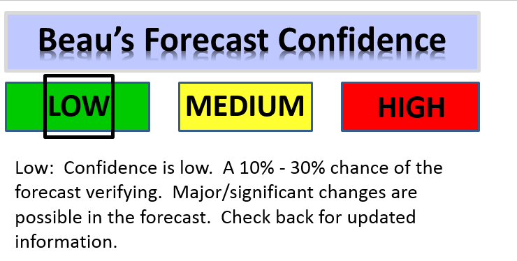
What do the confidence levels mean?


.
This forecast covers the counties in red.

This forecast covers the counties in red.
.
Tuesday Night – Partly cloudy. An isolated thunderstorm possible. Patchy fog possible.
What impact is expected? Maybe wet roadways and lightning.
Temperatures: Lows in the 74-76 degree range
Winds: Winds southwest at 4-8 mph with gusts to 12 mph.
What is the chance for precipitation at any given point? 20%-30%
Coverage of precipitation: Isolated to scattered.
Is severe weather expected? Unlikely. Small risk.
My confidence in this part of the forecast verifying: High
Should I cancel my outdoor plans? No, but monitor radars.
.
There is considerable debate about rain chances Wednesday-Sunday. This will need to be monitored. A series of disturbances will pass to our north. Low confidence on timing and placement of rain chances as we move through the week and weekend.
Another note: A low probability of rain does not mean it won’t rain. It means that the odds of rain at your location are X percent. At least that is how I am doing my probabilities. For example, a 30% chance for a thunderstorm actually means thunderstorms are likely to dot radar. But, the odds are that your location will remain dry.
Also, keep in mind that these are starting point numbers. They will likely need to be adjusted as we move forward and the details become clearer.
Wednesday – Partly sunny. Perhaps increasing clouds through the day. A few scattered morning storms possible. Then, a chance for locally heavy thunderstorms moving in from the west/northwest during the afternoon. Warm and muggy.
What impact is expected? Wet roadways and lightning. Heavy downpours in storms. Some storms could become severe with damaging winds.
Temperatures: High temperatures in the 85-90 degree range.
Winds: Southwest winds at 5-10 mph with gusts to 20 mph.
What is the chance for precipitation at any given point? 30% in the morning. Increasing to 60% during the afternoon.
Coverage of precipitation? Scattered to perhaps numerous
Is severe weather expected? Severe storms can’t be ruled out. Damaging winds being the primary concern.
My confidence in this part of the forecast verifying: Medium
Should I cancel my outdoor plans? No, but monitor updates and radars
Sunrise will be at 5:41 a.m. and sunset will be at 8:17 p.m.
UV index will be 7-9. Moderate to high.
Moonrise will be at 8:03 a.m. and moonset will be at 9:56 p.m. Waxing Crescent.
Wednesday Night – Partly cloudy. Warm. Humid. Scattered heavy thunderstorms are possible. Monitor updates in case storms develop and train over the same areas.
What impact is expected? Wet roadways and lightning. Heavy downpours in storms. If storms train then flash flooding could occur.
Temperatures: Lows in the 74-78 degree range
Winds: Winds southwest at 4-8 mph with gusts to 12 mph.
What is the chance for precipitation at any given point? 50%-60%
Coverage of precipitation: Scattered
Is severe weather expected? Monitor updates.
My confidence in this part of the forecast verifying: Medium
Should I cancel my outdoor plans? No, but monitor updates.
.
Thursday – Partly sunny. Scattered thunderstorms possible. Warm and humid.
What impact is expected? Wet roadways, lightning, and heavy downpours if storms form.
Temperatures: High temperatures in the 86-94 degree range.
Winds: Southwest winds at 5-10 mph with gusts to 20 mph.
What is the chance for precipitation at any given point? 30%
Coverage of precipitation? Perhaps scattered
Is severe weather expected? Unlikely, but monitor updates.
My confidence in this part of the forecast verifying: Low
Should I cancel my outdoor plans? No, but monitor radars
Sunrise will be at 5:42 a.m. and sunset will be at 8:17 p.m.
UV index will be 9-11. High.
Moonrise will be at 9:04 a.m. and moonset will be at 10:34 p.m. Waxing Crescent.
Thursday Night – Partly cloudy. Warm and humid.
What impact is expected? Isolated wet roadways and lightning.
Temperatures: Lows in the 74-78 degree range
Winds: Winds southwest at 4-8 mph.
What is the chance for precipitation at any given point? 20%
Coverage of precipitation: Perhaps isolated.
Is severe weather expected? Unlikely
My confidence in this part of the forecast verifying: Medium
Should I cancel my outdoor plans? No
.
Friday – Partly sunny. Warm and muggy. Scattered storms again possible.
What impact is expected? Wet roadways and lightning. Heavy downpours if storms form.
Temperatures: High temperatures in the 86-92 degree range. Isolated higher temperatures possible.
Winds: Southwest winds at 5-10 mph with gusts to 15 mph.
What is the chance for precipitation at any given point? 40%
Coverage of precipitation? Scattered
Is severe weather expected? Monitor updates
My confidence in this part of the forecast verifying: Low
Should I cancel my outdoor plans? No, but monitor radars
Sunrise will be at 5:42 a.m. and sunset will be at 8:16 p.m.
UV index will be 8-11. Moderate to high.
Moonrise will be at 10:04 a.m. and moonset will be at 11:08 p.m. Waxing Crescent.
Friday Night – Partly cloudy. Very warm. Humid. Thunderstorms possible.
What impact is expected? Wet roadways and lightning. Heavy downpours where storms form.
Temperatures: Lows in the 76-82 degree range
Winds: Winds west/southwest at 4-8 mph.
What is the chance for precipitation at any given point? 50%
Coverage of precipitation: Scattered to perhaps numerous
Is severe weather expected? Monitor updates
My confidence in this part of the forecast verifying: Low
Should I cancel my outdoor plans? No, but monitor radars
.
Saturday – Some clouds. Warm. Humid. Thunderstorms possible.
What impact is expected? Wet roadways and lightning if storms form. If storms form they could produce heavy rain.
Temperatures: High temperatures in the 84-88 degree range
Winds: West winds at 5-10 mph with gusts to 15 mph.
What is the chance for precipitation at any given point? 40%
Coverage of precipitation? Scattered to perhaps numerous. Monitoring a system moving in from the northwest.
Is severe weather expected? Monitor updates.
My confidence in this part of the forecast verifying: Low
Should I cancel my outdoor plans? Monitor updates
Sunrise will be at 5:43 a.m. and sunset will be at 8:16 p.m.
UV index will be 4-6. Moderate.
Moonrise will be at 11:04 a.m. and moonset will be at 11:41 p.m. Waxing Crescent.
Saturday Night – Partly cloudy. A thunderstorm possible.
What impact is expected? Likely none. If we can get thunderstorms out of here by Saturday then Saturday night should be dry. Low confidence.
Temperatures: Lows in the 66-72 degree range
Winds: Winds north and northwest at 4-8 mph.
What is the chance for precipitation at any given point? 30%
Coverage of precipitation:
Is severe weather expected?
My confidence in this part of the forecast verifying: Low
Should I cancel my outdoor plans?
.
Sunday – Partly sunny. A thunderstorm possible.
What impact is expected? Wet roadways and lightning. Heavy downpours if storms do form.
Temperatures: High temperatures in the 85-90 degree range
Winds: North winds at 5-10 mph with gusts to 15 mph.
What is the chance for precipitation at any given point? 30%
Coverage of precipitation?
Is severe weather expected?
My confidence in this part of the forecast verifying: Low
Should I cancel my outdoor plans?
Sunrise will be at 5:44 a.m. and sunset will be at 8:16 p.m.
UV index will be 8-10. Moderate to high.
Moonrise will be at –:– a.m. and moonset will be at 11:57 p.m. Waxing Crescent.
Sunday Night – Partly cloudy. A thunderstorm possible.
What impact is expected?
Temperatures: Lows in the 65-70 degree range
Winds: Winds north at 4-8 mph.
What is the chance for precipitation at any given point? 30%
Coverage of precipitation:
Is severe weather expected?
My confidence in this part of the forecast verifying: Low
Should I cancel my outdoor plans?
.
Monday – Partly sunny.
What impact is expected? Wet roadways and lightning. Heavy downpours if storms do form.
Temperatures: High temperatures in the 85-90 degree range
Winds: Variable winds at 5-10 mph with gusts to 15 mph.
What is the chance for precipitation at any given point? 30%
Coverage of precipitation?
Is severe weather expected?
My confidence in this part of the forecast verifying: Low
Should I cancel my outdoor plans?
Sunrise will be at 5:44 a.m. and sunset will be at 8:15 p.m.
UV index will be 8-10. Moderate to high.
Moonrise will be at 12:52 a.m. and moonset will be at 12:11 a.m. Waxing Crescent.
Monday Night – Partly cloudy. Warm and humid.
What impact is expected? Isolated wet roadways and lightning.
Temperatures: Lows in the 74-78 degree range
Winds: Winds variable at 4-8 mph.
What is the chance for precipitation at any given point? 20%
Coverage of precipitation:
Is severe weather expected?
My confidence in this part of the forecast verifying: Low
Should I cancel my outdoor plans?
.
Tuesday – Partly sunny.
What impact is expected?
Temperatures: High temperatures in the 85-90 degree range
Winds: Southeast winds at 5-10 mph with gusts to 15 mph.
What is the chance for precipitation?
Coverage of precipitation?
Is severe weather expected?
My confidence in this part of the forecast verifying: Low
Should I cancel my outdoor plans?
Sunrise will be at 5:45 a.m. and sunset will be at 8:15 p.m.
UV index will be 8-10. Moderate to high.
Moonrise will be at 1:47 p.m. and moonset will be at 12:42 a.m. Waxing Gibbons.
Tuesday Night – Partly cloudy.
What impact is expected?
Temperatures: Lows in the 70-74 degree range
Winds: Winds southwest at 4-8 mph.
What is the chance for precipitation? 20%
Coverage of precipitation:
Is severe weather expected?
My confidence in this part of the forecast verifying: Low
Should I cancel my outdoor plans?
More information on the UV index. Click here.
The weekend forecast is sponsored by Farmer and Company Real Estate.

Farmer & Company Real Estate is proud to represent buyers and sellers in both Southern Illinois and Western Kentucky. With 13 licensed brokers, we can provide years of experience to buyers & sellers of homes, land & farms and commercial & investment properties. We look forward to representing YOU! Follow us on Facebook, as well
The weekend forecast is sponsored by Farmer and Company Real Estate. Click here to visit their site.


Don’t forget to check out the Southern Illinois Weather Observatory web-site for weather maps, tower cams, scanner feeds, radars, and much more! Click here

An explanation of what is happening in the atmosphere over the coming days…
- Complicated forecast
- Possibility of addition heavy rainfall in the region
- Severe weather risk
The main concern over the coming days will be torrential rainfall totals. Thunderstorm complexes, known as MCS’s, will push into our region from the west and northwest over the coming days. Data indicates the possibility of several of these thunderstorm complexes impacting at least portions of our region.
What is a Mesoscale Convective System? Large thunderstorm complexes that form in the late spring and summer months. Here is a great educational lesson on this topic…click here
It is nearly to impossible to forecast the exact track of these type of events. During the summer months the upper level steering currents are weak. And, large thunderstorm complexes can actually develop their out steering mechanism.
Typically an MCS can be forecast about 12-18 hours in advance. Perhaps a bit further out for the general details. But, finer details are rarely known until the event develops. Thus, the overall forecast confidence for the coming week and weekend is rather low. Low meaning that changeable forecasts are likely. Stay tuned and monitor updates.
The confidence that we will have thunderstorms on radar is high.
My main concern for the coming week and weekend will be how much rain falls. PWAT values, a measure of moisture in the atmosphere, will once again top two inches. This is on the upper level extreme. If thunderstorms train over the same areas then anywhere from 1-3″ of rain could fall within an hour. And, pockets of greater than three inches is likely. The exact counties where this could occur will be determined by the track of each MCS. And, again, that isn’t known yet.
We have several upper level vort maxes to track. The upper level vort maxes are responsible for the development of thunderstorms.
Another concern will be the amount of energy in the atmosphere. July typically produces soupy air masses. Very unstable atmospheric conditions. I can’t rule out severe thunderstorms with damaging wind gusts. Monitor all watches and warnings over the coming days.
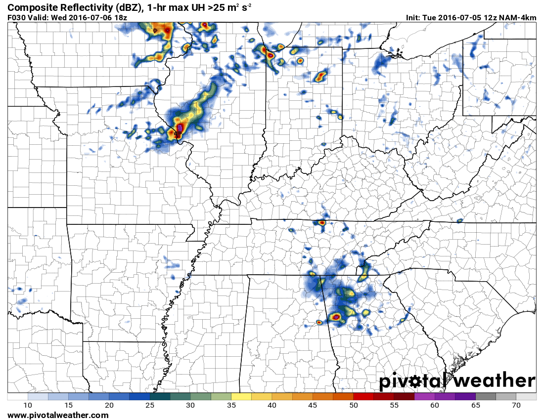
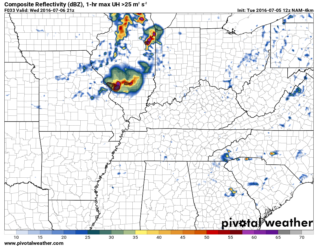
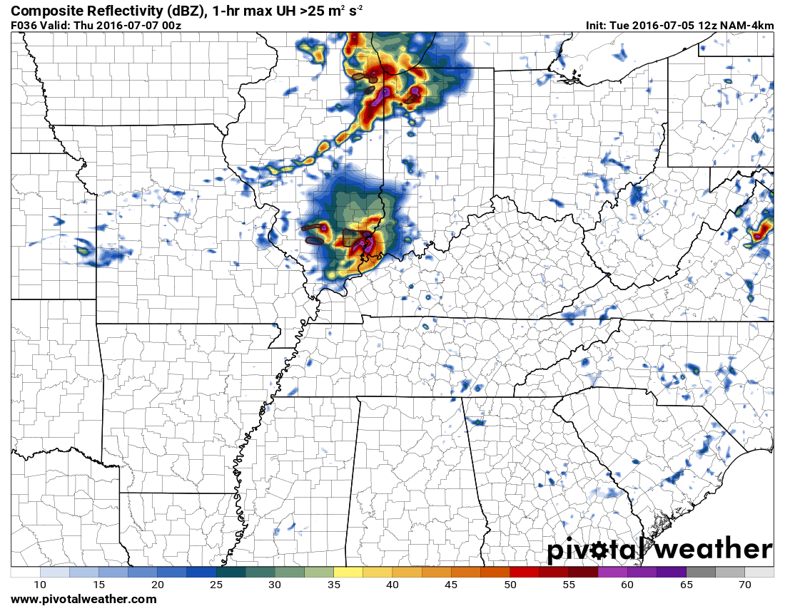
Some maps
These are future-cast radar maps. Now, this will NOT be exact. And, models have handled these features poorly over the last few days. So, I will show you these maps, but don’t get too caught up on the exact placement of the thunderstorms.
The placement of the upper level features will be key to exact track. So, don’t take this as gospel.
This first map is for Wednesday around 1 p.m. A line of strong to severe thunderstorms approaching St Louis, Missouri. This complex will move southeast. Whether it ends up northeast of this location is a question. Some models show it further into central Illinois.
The colors represent rain and storms. Red is heavy rain. Same as you would see on your live radar screens. This is just a future-cast radar screen. What radar might look like.
This next image is for 4 p.m. on Wednesday. The line is moving south and southeast. This line could produce damaging winds. Let’s keep an eye on it.
This next image is for 7 p.m. on Wednesday evening. The first line is moving through our region. Models show another storm complex well to the north. This will need to also be monitored.
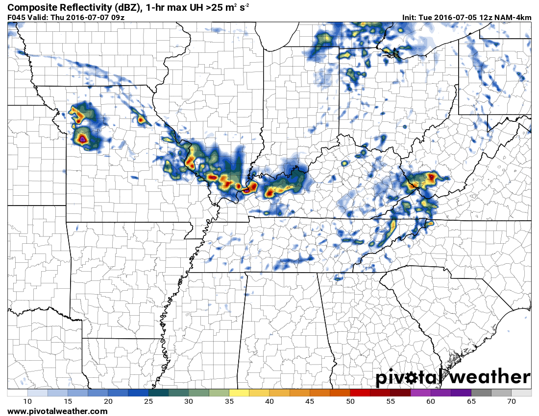
This next image is for Thursday morning at 1 a.m.
If this develops then flash flooding can’t be ruled out. Some of these storms could train over the same areas. Rainfall totals of 1-3″ per hour will be possible. Again, low confidence on this forecast. But, worth monitoring.
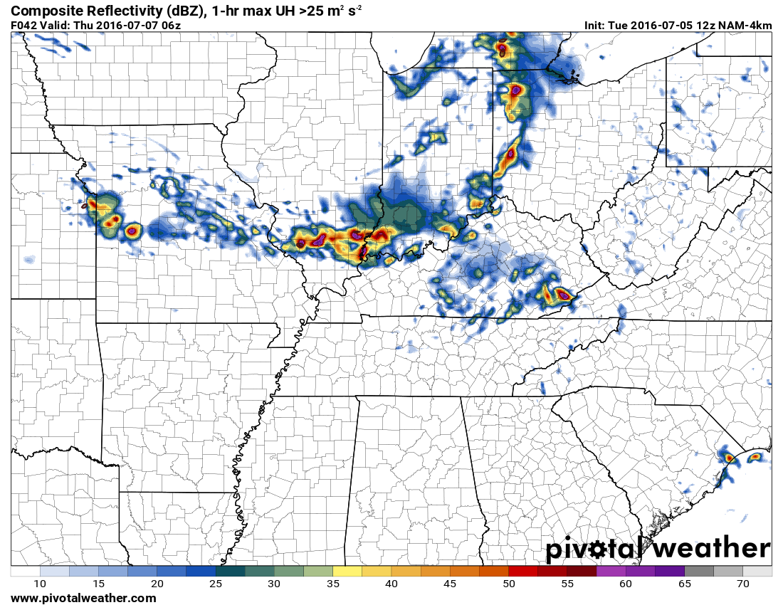
This next image is for 4 a.m. on Thursday morning. Heavy storms in the region if the NAM is correct. They are slow moving.
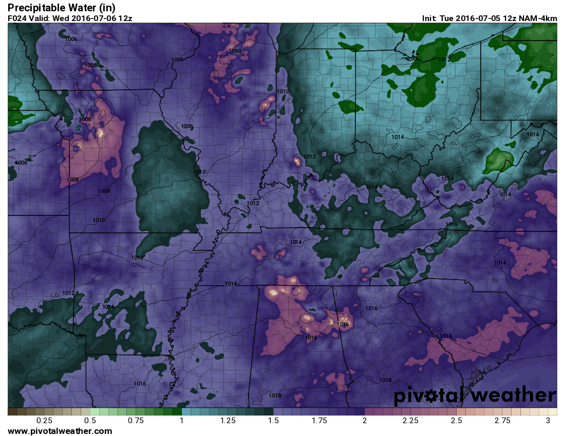
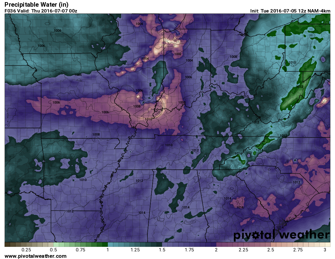
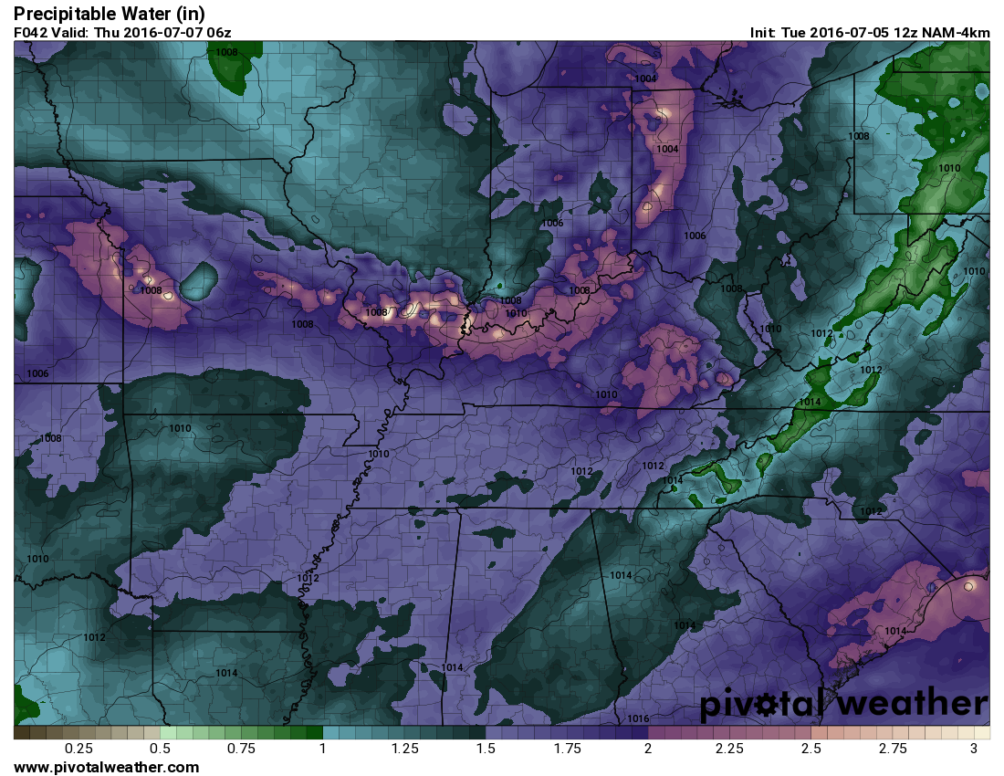
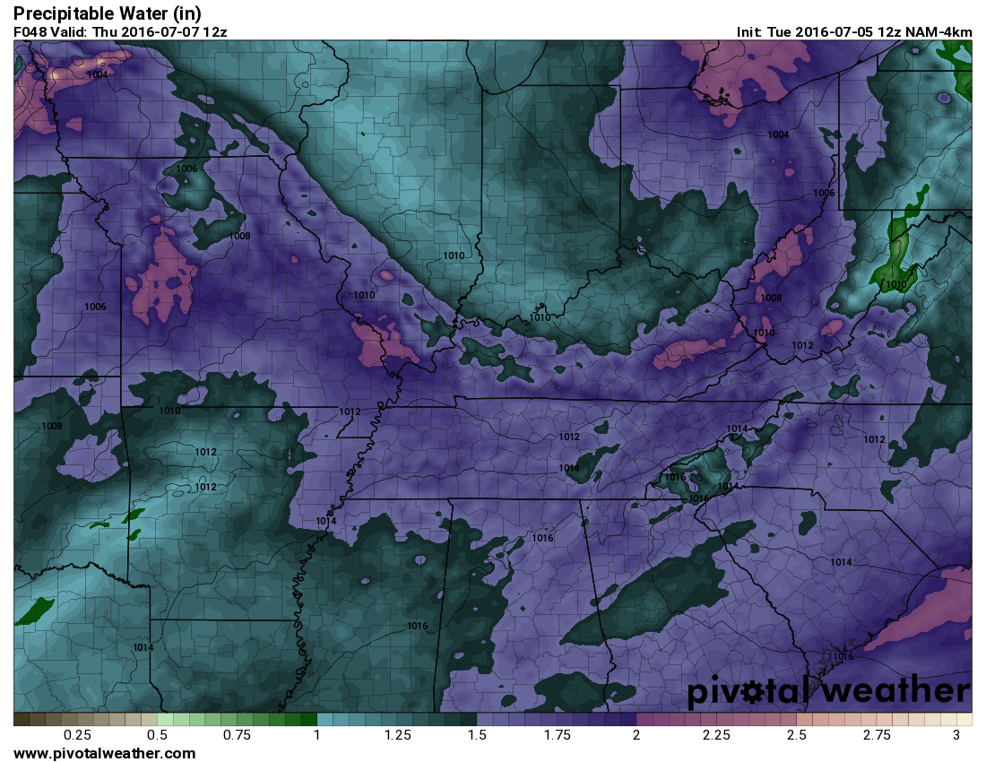
Here are PWAT values. PWAT is a great way to measure moisture in the atmosphere. The higher the numbers the better chance for heavy rain. PWAT values will top two inches over the coming week. Those are very big numbers. And, equal the potential for some big downpours.
What are PWAT values? Great question! I found this blog post that explains it quite well. Click here for more information on PWAT values.
This first graphic is the 7 am Wednesday morning numbers. Now, keep in mind, you have to have a trigger for storms. You can have high PWAT values, but without a trigger you won’t have heavy rain.
What to look for in PWAT value charts is a long duration of high PWAT’s. That is usually an indication that some heavy rain may occur.
This next map is for 1 pm on Wednesday. The purple and white colors are PWAT values topping 2.1″.
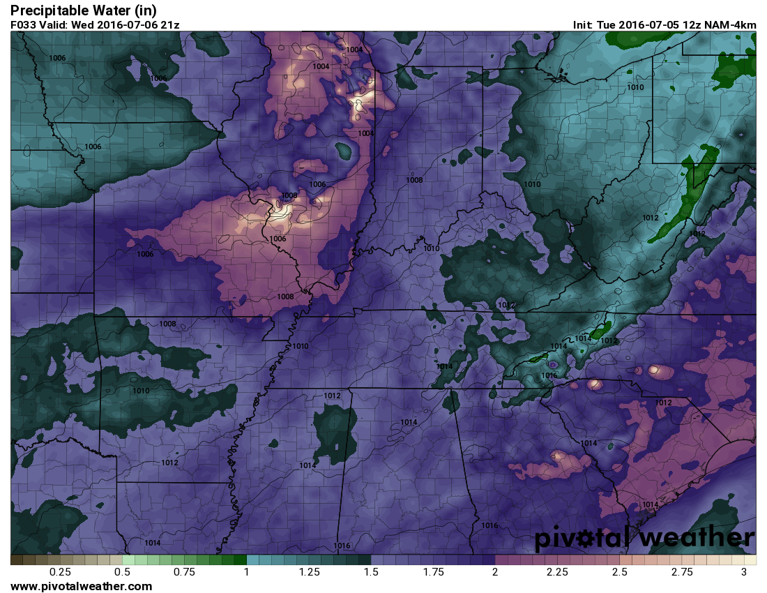
This next map is for 7 p.m. Wednesday evening. See how the colors are lined from west to east. That is something else I look for when considering heavy rain potential. If upper level winds are parallel with this map then training storms could occur and tap into the high PWAT values. And, the upper level winds are parallel.
Here is the map for 1 a.m. on Thursday morning. Still, big numbers in the region.
Thursday morning map at 7 a.m. Notice how the high PWAT values stick around.
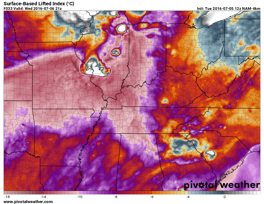
Here is the lifted index map. This map shows lifted index values of -9 to -14 in our region. Those are big numbers for any month. The LI index values are used in forecasting severe weather. One parameter. Anytime you go below 0 you have a chance for thunderstorms. A -9 to -14 range indicates a very unstable environment.
Storm Tracking Radar


We have regional radars and local city radars – if a radar does not seem to be updating then try another one. Occasional browsers need their cache cleared. You may also try restarting your browser. That usually fixes the problem. Occasionally we do have a radar go down. That is why I have duplicates. Thus, if one fails then try another one.
If you have any problems then please send me an email beaudodson@usawx.com
WEATHER RADAR PAGE – Click here —
We also have a new national interactive radar – you can view that radar by clicking here.
Local interactive city radars include St Louis, Mt Vernon, Evansville, Poplar Bluff, Cape Girardeau, Marion, Paducah, Hopkinsville, Memphis, Nashville, Dyersburg, and all of eastern Kentucky – these are interactive radars. Local city radars – click here

Live Lightning Data – zoom and pan: Click here
Live Lightning Data with sound (click the sound button on the left side of the page): Click here

Can we expect severe thunderstorms over the next 24 to 48 hours? Remember that a severe thunderstorm is defined as a thunderstorm that produces 58 mph winds or higher, quarter size hail or larger, and/or a tornado.
.
Tuesday night: A few scattered thunderstorms possible. Heavy rain and lightning will be the main concern.
Wednesday and Wednesday night: Some strong to severe thunderstorms are possible. Monitor updates. Storms would approach from the west/northwest. Damaging wind would be the main concern.
Thursday-Sunday: Several periods of strong thunderstorms are possible. Timing each system is tricky, at best. Monitor updates concerning the potential for heavy rain and other.
.

.
No huge swings in this update. Although, I continue to tweak rain probability numbers. Timing each of the upper level disturbances won’t be easy. And, placement of the key features is also difficult to predict more than twelve hours in advance.
.

.
The main concern over the coming days will be additional rain. Many of us do not need more rain. I realize some spots still need a little precipitation. But, much of the region is soaked.
Lightning will be a concern for outdoor events this week. I also can’t rule out severe thunderstorms. Damaging wind being the primary concern.
.

.
Avoid flooded roadways. Monitor watches and warnings over the coming days.
Lightning is a concern for outdoor activities. Perhaps monitor radars from time to time. And, monitor updates forecasts this week. Changeable weather is possible.
.

How much precipitation should we expect over the next few days?
.
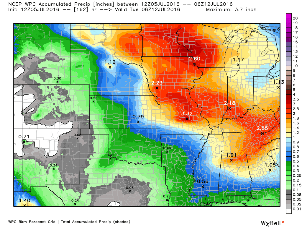
Thunderstorms over the coming days could produce locally heavy rain. It is July and there is no lack of moisture in the atmosphere. Where storms form they would produce heavy downpours. Rainfall totals will vary considerably.
If some of these disturbances come together as forecast then some spots could top two or three inches over the coming week. Monitor updates.
Here is the broad-brushed rainfall outlook. But, keep in mind, this will be way off where thunderstorms train over the same areas. Those areas could pick up a lot more rain.
.

Here are the current river stage forecasts. You can click your state and then the dot for your location. It will bring up the full forecast and hydrograph.
..

Here is the official 6-10 day and 8-14 day temperature and precipitation outlook. Check the date stamp at the top of each image (so you understand the time frame).
The forecast maps below are issued by the Weather Prediction Center (NOAA).


The latest 8-14 day temperature and precipitation outlook. Note the dates are at the top of the image. These maps DO NOT tell you how high or low temperatures or precipitation will be. They simply give you the probability as to whether temperatures or precipitation will be above or below normal.


Who do you trust for your weather information and who holds them accountable?
I have studied weather in our region since the late 1970’s. I have 37 years of experience in observing our regions weather patterns. My degree is in Broadcast Meteorology from Mississippi State University and an Associate of Science (AS). I am currently working on my Bachelor’s Degree in Geoscience.
My resume includes:
Member of the American Meteorological Society.
NOAA Weather-Ready Nation Ambassador.
Meteorologist for McCracken County Emergency Management. I served from 2005 through 2015.
I own and operate the Southern Illinois Weather Observatory.
Recipient of the Mark Trail Award, WPSD Six Who Make A Difference Award, Kentucky Colonel, and the Caesar J. Fiamma” Award from the American Red Cross.
In 2009 I was presented with the Kentucky Office of Highway Safety Award.
Recognized by the Kentucky House of Representatives for my service to the State of Kentucky leading up to several winter storms and severe weather outbreaks.
I am also President of the Shadow Angel Foundation which serves portions of western Kentucky and southern Illinois.
There is a lot of noise on the internet. A lot of weather maps are posted without explanation. Over time you should learn who to trust for your weather information.
My forecast philosophy is simple and straight forward.
- Communicate in simple terms
- To be as accurate as possible within a reasonable time frame before an event
- Interact with you on Twitter, Facebook, and the blog
- Minimize the “hype” that you might see on television or through other weather sources
- Push you towards utilizing wall-to-wall LOCAL TV coverage during severe weather events
I am a recipient of the Mark Trail Award, WPSD Six Who Make A Difference Award, Kentucky Colonel, and the Caesar J. Fiamma” Award from the American Red Cross. In 2009 I was presented with the Kentucky Office of Highway Safety Award. I was recognized by the Kentucky House of Representatives for my service to the State of Kentucky leading up to several winter storms and severe weather outbreaks.
If you click on the image below you can read the Kentucky House of Representatives Resolution.

Many of my graphics are from www.weatherbell.com – a great resource for weather data, model data, and more


You can sign up for my AWARE email by clicking here I typically send out AWARE emails before severe weather, winter storms, or other active weather situations. I do not email watches or warnings. The emails are a basic “heads up” concerning incoming weather conditions.