We have some great sponsors for the Weather Talk Blog. Please let our sponsors know that you appreciate their support for the Weather Talk Blog.
Milner and Orr Funeral Home and Cremation Services located in Paducah, Kentucky and three other western Kentucky towns – at Milner and Orr they believe in families helping families. You can find Milner and Orr on Facebook, as well.
![]()
Check out our sponsors! There are more on the right side bar of the page, as well. Be sure and let them know that you appreciate their sponsorship of the WeatherTalk daily weather bulletin.

Wortham Dental Care located in Paducah, Kentucky. The gentle dentist. Mercury free dentistry. They also do safe Mercury removal. You can find Wortham Dental Care on Facebook, as well
.

Trover’s Equipment and Lawn Care – Family owned and operated! They are a dealer for Snapper, Simplicity, Snapper Pro, Bad Boy Mowers, and Intimidator Utility Vehicles. They are a Stihl and Dolmar power products dealer. They also are a dealer for Briggs & Stratton, Kohler gas & diesel engines, and Kawasaki engines. They service and repair just about any brand. You can find them on Facebook, as well
.

Visit their web-site here. Or, you can also visit their Facebook page.

Endrizzi’s Storm Shelters – For more information click here. Endrizzi Contracting and Landscaping can be found on Facebook, as well – click here
Are you looking for a full service insurance agency that writes homes, businesses, and vehicles in Illinois, Kentucky, and Tennessee. Call Gary’s office at 270.442.8234 for rates and plans to protect what matters to you!

Gary Eckelkamp’s web-site click the above banner or click here

This forecast update covers far southern Illinois, far southeast Missouri, and far western Kentucky. See the coverage map on the right side of the blog.
Remember that weather evolves. Check back frequently for updates, especially during active weather.
The forecast numbers below may vary a bit across the region. These are the averages.
WEATHER RADAR PAGE – Click here —
Sunday night – Mostly clear. Nice. A couple of storms possible around the KY/TN border counties and the Missouri Bootheel.
Temperatures: Lows in the 60’s
Winds: South winds at 5 mph. Gusts of 5-10 mph on lakes.
My confidence in this part of the forecast verifying is high
Should I cancel my outdoor plans? No
Is severe weather expected? No
What is the chance for precipitation? 10% chance
What impact is expected? If storms occur then lightning and a heavy downpour possible.
Monday – Partly sunny. a couple of scattered thunderstorms possible. Heat index will be warm. It will be more humid. Heat index values will be in the 90’s.
Temperatures: Highs from 82 to 86 degrees
Winds: South and southwest winds at 5-10 mph with gusts to around 15 mph possible on area lakes.
My confidence in this part of the forecast verifying is high
Should I cancel my outdoor plans? No
What is the chance for precipitation? 20%-30% chance at any given location in the area
What impact is expected? If a storm forms then it could produce lightning, heavy rain, and gusty winds.
Monday night – Partly cloudy in the evening with a slight chance for a shower or thunderstorm. Partly cloudy late with a few thunderstorms possible. Especially over southeast Missouri and southern Illinois.
Temperatures: Lows in the 60’s to lower 70’s
Winds: South and southwest winds at 5-10 mph.
My confidence in this part of the forecast verifying is high
Should I cancel my outdoor plans? No
Is severe weather expected? No
What is the chance for precipitation? 20%-30% chance
What impact is expected? If storms occur then lightning and a heavy downpour possible.
Tuesday – Partly to mostly cloudy. A 40%-50% chance for showers and thunderstorms. Heavy rain possible where storms occur. Best chances on Tuesday might be over southeast Missouri and southern Illinois vs western Kentucky. This will depend on how far south and east the cold front swings. We will have to see how far south the fronts sags.
Temperatures: Highs from 80 to 85 degrees
Winds: West and southeast winds at 5-10 mph.
My confidence in this part of the forecast verifying is medium
Should I cancel my outdoor plans? I would monitor radars on Tuesday. Precipitation is possible.
What is the chance for precipitation? 40%-50% chance
What impact is expected? Storms could produce lightning, heavy rain, and gusty winds.
Tuesday night – Cloudy. Showers and thunderstorms possible over southeast Missouri and southern Illinois. Scattered storms possible over western Kentucky and northwest Tennessee.
Temperatures: Lows in the 60’s to lower 70’s.
Winds: South and southwest winds at 5-10 mph.
My confidence in this part of the forecast verifying is medium
Should I cancel my outdoor plans? I would have a back up plan.
Is severe weather expected? Minimal risk.
What is the chance for precipitation? 50%-70% chance over southeast MO and southern IL. 30%-40% elsewhere.
What impact is expected? Where storms occur then lightning and a heavy downpour possible. Gusty winds.
Wednesday – Partly sunny. Not as warm. A chance for thunderstorms. Where storms occur there could be locally heavy rainfall totals. Best chances on Wednesday might again be over southeast Missouri and southern Illinois vs Kentucky and Tennessee. This will depend on the placement of the cold front. Models are not in agreement as to how far south the front pushes.
Temperatures: Highs from 80 to 85 degrees
Winds: Variable winds in the area. South of the front we will have southwest winds. North of the front there will be east and southeast winds at 5-10 mph.
My confidence in this part of the forecast verifying is medium
Should I cancel my outdoor plans? Might have a backup plan in case it does rain.
What is the chance for precipitation? 40%-50% chance
What impact is expected? Storms could produce lightning, heavy rain, and gusty winds
![]()
Sunrise and Sunset Times – Click Here


Don’t forget to check out the Southern Illinois Weather Observatory web-site for weather maps, tower cams, scanner feeds, radars, and much more! Click here

An explanation of what is happening in the atmosphere over the coming days…
Highlights
1. A cold front is approaching for the new work week
2. More heavy rain possible (for some)?
3. River flooding continues…see the lake and river stages for more information on crest levels.
4. I have some advertiser or sponsorship spots available on the blog and on Facebook. Contact me for details at beaudodson@usawx.com
I hope you have had a nice holiday weekend? The rain held off for most counties in the region on Sunday. Yes, the Missouri Bootheel and a few counties along the Kentucky and Tennessee border had to deal with some storms, but for the most part it was okay.
Temperatures are Sunday were not bad. Do you realize we spend the last part of June and the first 5 days of July with below normal temperatures? Not bad…not bad! We deserved a break after the hot weather we experienced earlier in June.
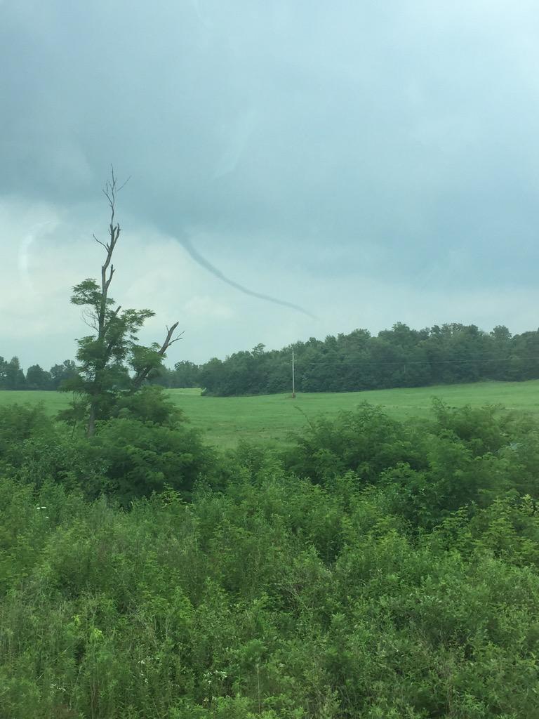
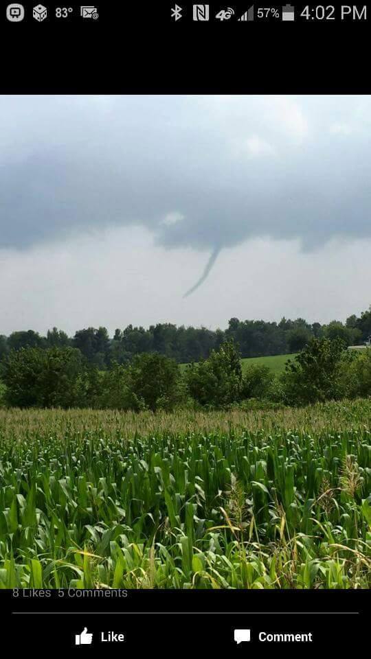
If you live in Webster or Hopkins County, Kentucky then you might have observed a tornado or funnel cloud today. Appears it was very close to the ground. This might be what meteorologists call a landspout.
I received several photographs of the tornado/landspout. Here they are
This one was taken by Isaac Henson
This one was taken by Darryl Clark
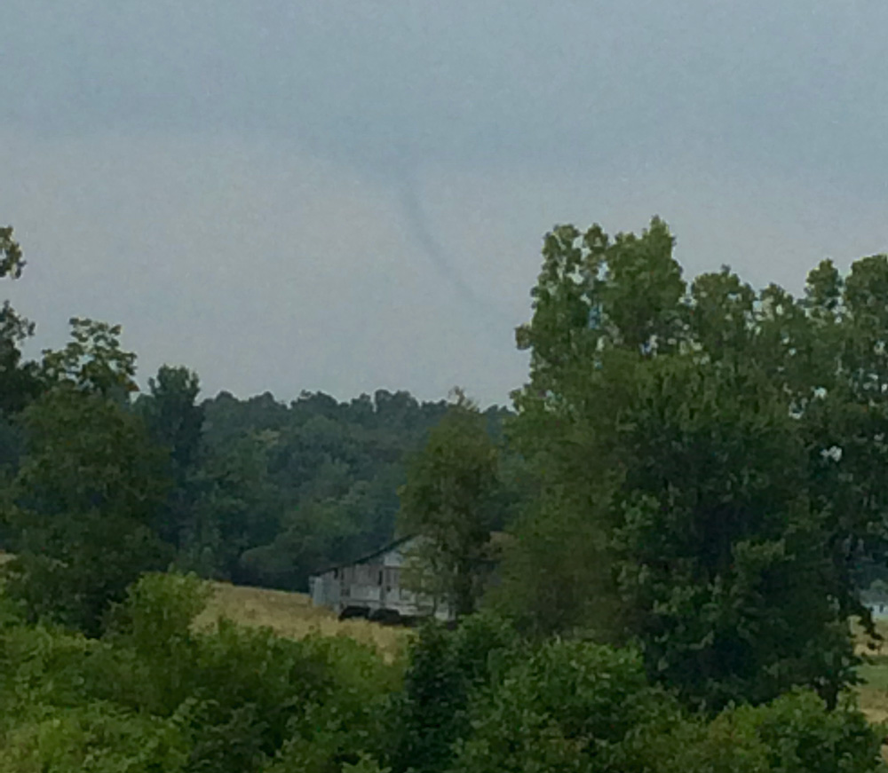
And this final photograph is unknown photographer
The image below is from social media. Unknown photographer. Taken from Wrightsburg Hill. Looking southwest of Beech Grove.
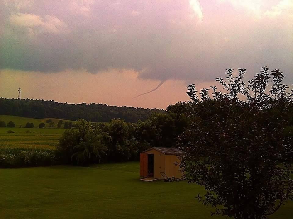
I have not heard of any damage. Radar indicated a very weak shower in the area. Quite strange. I believe this was a landspout
Here is the radar image
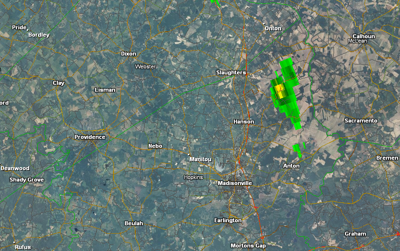
More information on land spouts can be read here
The new work week will bring yet another cold front into our region from the west and northwest. This front will once again be accompanied by widespread showers and thunderstorms. Is this July? Someone tell nature that this is July.
Not that we need more rain. Some of you still have standing water in the fields, creeks are high, rivers are high, and the ground is nearly saturated. But, more rain is on the way. Let’s break it down.
Monday into Wednesday:
Cold front approaches from the west and northwest on Monday night. The front will bump into warm and moist air over the region. The end result will be rapid development of a large area of showers and thunderstorms.
Although we may have a few scattered storms on Monday and Monday evening, the main activity is forecast to develop late Monday night and on Tuesday. Then lasting into at least Wednesday (for chance probabilities).
There are some uncertainties as to how far south and east the cold front will move towards the middle of the new work week. The further north and west the front is stationed…the better the chances for showers and storms over our northern and western counties.
If the front sags all the way into Kentucky then we will all have solid chances for some locally moderate to heavy rain.
Rainfall totals will once again vary considerably over the region. A widespread 0.50″-1.50″ event appears almost certain. 1″-3″ appears very possible in some counties (esp southeast MO and southern IL). And a few counties could end up with more than 3″ of rain. The highest probability of the bigger totals will be over portions of southeast Missouri into southern Illinois. Perhaps from around Poplar Bluff, MO towards Cape Girardeau, Missouri and then into the White County area of southern Illinois.
Again, the exact placement of the front is going to be key as to whether you end up with big rain totals or lower rain totals. Everyone, however, should experience rain from this event.
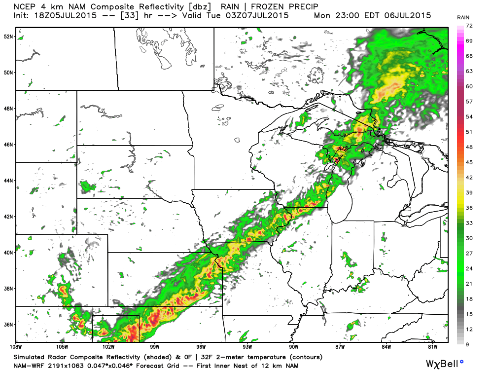
Let’s look at the WRF model. It brings the front into our region late late Monday night into Tuesday night. There remain some questions about the placement of the front. Keep that in mind. Lower confidence than normal.
Here is the 10 pm future-cast radar from weatherbell.com
You can see the storms lined up along the front
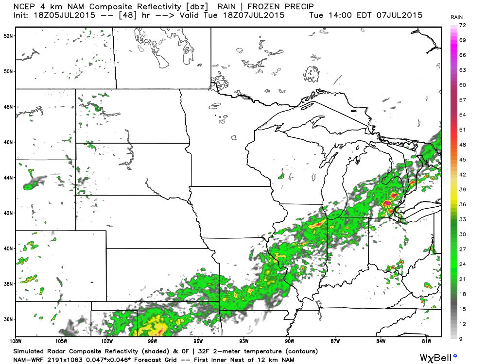
Now, moving ahead to Tuesday at 12 pm to 1 pm. This is what radar might look like. (below)
And then by Tuesday evening
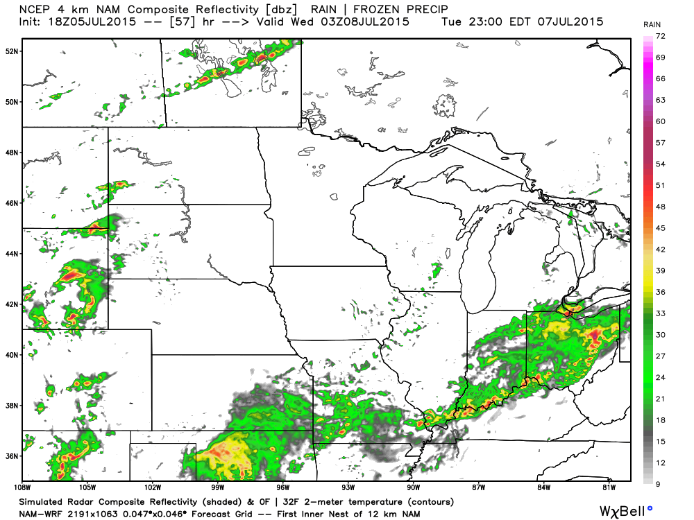
The front will likely stall out around Wednesday. It is possible that it will move back north as a warm front on Thursday and Friday, but there is no agreement in the data as to whether this happens.
When all is said and done, I think the biggest rainfall totals will end up over Missouri and Illinois. But, as always…we shall see.
Temperatures will start out the week near to above normal and then on Tuesday and Wednesday drop back down below normal.
IF the front moves north as a warm front late in the week then temperatures will become more seasonable. At least for a little while.
Severe weather?
Although I can’t completely rule out an isolated severe thunderstorm, overall it appears the risk is minimal. Bigger concern will be additional heavy rain.
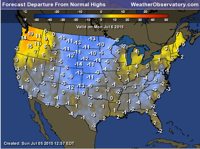
Let’s once again check out the temperature anomalies for Monday. Normal to slightly below normal? Will be close. These are high temperature departures. Look what is coming in from the northwest behind that next cold front. How far will the front push? That is the question.
These numbers represent how many degrees above or below normal temperatures will be

This section of the blog is speculative forecast information. Because it is past the range of what meteorologists can forecast accurately, it should be considered speculation. Anything past day 5 is considered a long range forecast.
Highlights
1. What about the third and fourth week of July?
2. River flooding concerns
I am having a difficult time resolving what the pattern will look like the third and fourth weeks of July. I am torn between what happens with the ridge of high pressure (that if it builds in will return us to hot weather) and the potential for another trough. There are multiple typhoons in the Pacific and their eventual track could very well determine the outcome of our weather for the last week or two of July.
We might play a bit of a tug of war between the ridge and troughs.
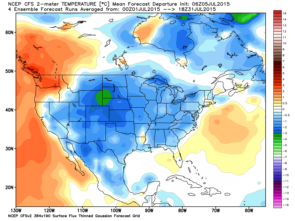
Check out on set of models idea for July. We already know the first week of July was below normal. But, is it possible that much of July will end up that way?
River flooding continues to be an issue in our region. Recent heavy rainfall isn’t helping our cause. More heavy rain could cause additional problems.
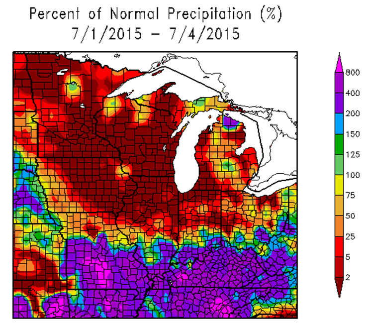
The forecast was for July to have above normal precipitation.
Here is the percent of normal rainfall for July 1st through July 4th.
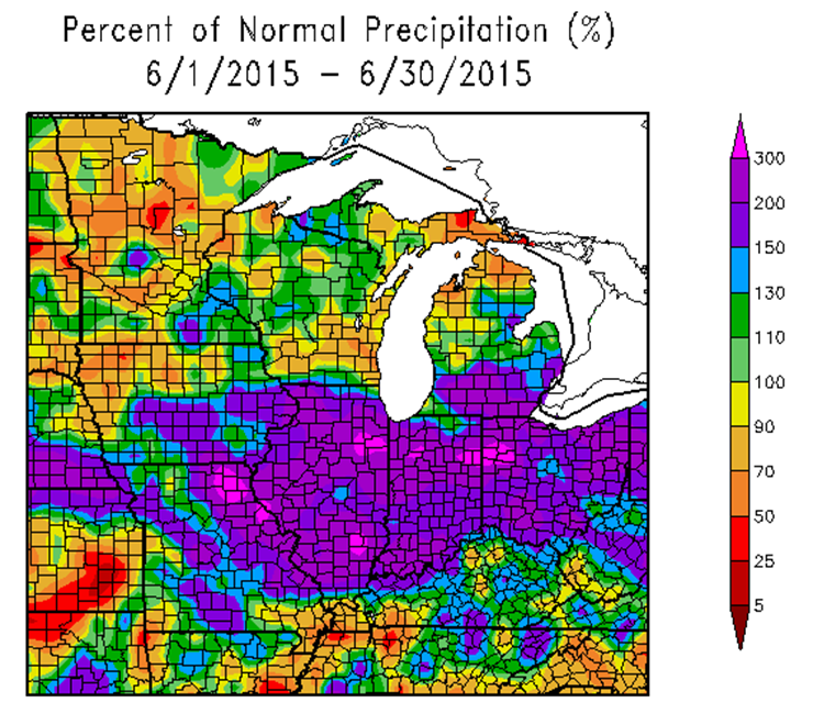
June was wet for much of our region, but not all. Here is the June map
Radars
WEATHER RADAR PAGE – Click here —

I also set up a storm tracking page with additional links (use during active weather for quick reference)
Storm Tracking Tool Page
Don’t forget to support our sponsors!

How much precipitation should we expect over the next few days?
As we enter the late spring and summer months, keep in mind that slow moving thunderstorms can always produce locally heavy rainfall totals. This is no secret to all of you who are farmers. Your neighbors could pick up 1″ of rain from a thunderstorm, meanwhile you are sitting on dry ground. Forecasting exact rainfall totals during this time of the year can be tricky, at best
Rainfall amounts for Monday will be spotty. If storms pop up then a quick 0.25″-0.50″ of rain is possible in a few spots. Most areas will remain dry.
Tuesday into Thursday will bring better rain chances with pockets of 1-3″+ again possible. Same as this past week.
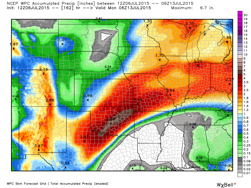
Here is the official rainfall forecast (broad-brushed) for the upcoming week. Most of this falls from TUE into THUR
There was a little shift northward for the heavier rain totals. This is because of the front stalling out before it reaches too far into Kentucky and Tennessee. Image is from weatherbell.com
Click the image to view a larger size.

Can we expect severe thunderstorms over the next 24 to 48 hours? Remember that a severe thunderstorm is defined as a thunderstorm that produces 58 mph winds or higher, quarter size hail or larger, and/or a tornado.
Thunderstorm threat level is a ONE on Monday and a TWO on Tuesday.
Monday Severe Weather Outlook – A scattered storm possible. Not forecasting severe storms.
Tuesday Severe Weather Outlook – Storms are likely, but most should remain below severe levels.
Wednesday Severe Weather Outlook – Storms are likely in the area. Severe weather risk is minimal.
Thursday Severe Weather Outlook – Severe weather is not anticipated


Rivers remain high.
Lightning, as always.

Here are the current river stage forecasts. You can click your state and then the dot for your location. It will bring up the full forecast and hydrograph.
Click Here For River Stage Forecasts…
Here are some current forecast hydrographs. These will be updated each day with new information.


Smithland Lock and Dam

Paducah, Kentucky Forecast Stage

Cairo, Illinois

Cape Girardeau, Missouri
Current Temperatures Around The Local Area


We have regional radars and local city radars – if a radar does not seem to be updating then try another one. Occasional browsers need their cache cleared. You may also try restarting your browser. That usually fixes the problem. Occasionally we do have a radar go down. That is why I have duplicates. Thus, if one fails then try another one.
If you have any problems then please send me an email beaudodson@usawx.com
WEATHER RADAR PAGE – Click here —
We also have a new national interactive radar – you can view that radar by clicking here.
Local interactive city radars include St Louis, Mt Vernon, Evansville, Poplar Bluff, Cape Girardeau, Marion, Paducah, Hopkinsville, Memphis, Nashville, Dyersburg, and all of eastern Kentucky – these are interactive radars. Local city radars – click here
NOTE: Occasionally you will see ground clutter on the radar (these are false echoes). Normally they show up close to the radar sites – including Paducah.

Regional Radar – Click on radar to take you our full radar page.


Regional Radar

Live Lightning Data – zoom and pan: Click here
Live Lightning Data with sound (click the sound button on the left side of the page): Click here
I also set up a storm tracking page with additional links (use during active weather for quick reference)
Storm Tracking Tool Page
![]()
Current WARNINGS (a warning means take action now). Click on your county to drill down to the latest warning information. Keep in mind that there can be a 2-3 minute delay in the updated warning information.
I strongly encourage you to use a NOAA Weather Radio or warning cell phone app for the most up to date warning information. Nothing is faster than a NOAA weather radio.


Color shaded counties are under some type of watch, warning, advisory, or special weather statement. Click your county to view the latest information.

Missouri Warnings

Illinois Warnings

Kentucky Warnings

Here is the official 6-10 day and 8-14 day temperature and precipitation outlook. Check the date stamp at the top of each image (so you understand the time frame).
The forecast maps below are issued by the Weather Prediction Center (NOAA).


The latest 8-14 day temperature and precipitation outlook. Note the dates are at the top of the image. These maps DO NOT tell you how high or low temperatures or precipitation will be. They simply give you the probability as to whether temperatures or precipitation will be above or below normal.


Who do you trust for your weather information and who holds them accountable?
I have studied weather in our region since the late 1970’s. I have 37 years of experience in observing our regions weather patterns. My degree is in Broadcast Meteorology from Mississippi State University and an Associate of Science (AS). I am currently working on my Bachelor’s Degree in Geoscience. Just need to finish two Spanish classes!
I am a member of the American Meteorological Society. I am a NOAA Weather-Ready Nation Ambassador. And, I am the Meteorologist for McCracken County Emergency Management.
I own and operate the Southern Illinois Weather Observatory.
There is a lot of noise on the internet. A lot of weather maps are posted without explanation. Over time you should learn who to trust for your weather information.
My forecast philosophy is simple and straight forward.
- Communicate in simple terms
- To be as accurate as possible within a reasonable time frame before an event
- Interact with you on Twitter, Facebook, and the blog
- Minimize the “hype” that you might see on television or through other weather sources
- Push you towards utilizing wall-to-wall LOCAL TV coverage during severe weather events
I am a recipient of the Mark Trail Award, WPSD Six Who Make A Difference Award, Kentucky Colonel, and the Caesar J. Fiamma” Award from the American Red Cross. In 2009 I was presented with the Kentucky Office of Highway Safety Award. I was recognized by the Kentucky House of Representatives for my service to the State of Kentucky leading up to several winter storms and severe weather outbreaks.
If you click on the image below you can read the Kentucky House of Representatives Resolution.

I am also President of the Shadow Angel Foundation which serves portions of western Kentucky and southern Illinois.
Many of my graphics are from www.weatherbell.com – a great resource for weather data, model data, and more


You can sign up for my AWARE email by clicking here I typically send out AWARE emails before severe weather, winter storms, or other active weather situations. I do not email watches or warnings. The emails are a basic “heads up” concerning incoming weather conditions.