We have some great sponsors for the Weather Talk Blog. Please let our sponsors know that you appreciate their support for the Weather Talk Blog.
Milner and Orr Funeral Home and Cremation Services located in Paducah, Kentucky and three other western Kentucky towns – at Milner and Orr they believe in families helping families. You can find Milner and Orr on Facebook, as well.
![]()
Check out our sponsors! There are more on the right side bar of the page, as well. Be sure and let them know that you appreciate their sponsorship of the WeatherTalk daily weather bulletin.

Wortham Dental Care located in Paducah, Kentucky. The gentle dentist. Mercury free dentistry. They also do safe Mercury removal. You can find Wortham Dental Care on Facebook, as well
.

Trover’s Equipment and Lawn Care – Family owned and operated! They are a dealer for Snapper, Simplicity, Snapper Pro, Bad Boy Mowers, and Intimidator Utility Vehicles. They are a Stihl and Dolmar power products dealer. They also are a dealer for Briggs & Stratton, Kohler gas & diesel engines, and Kawasaki engines. They service and repair just about any brand. You can find them on Facebook, as well
.

Visit their web-site here. Or, you can also visit their Facebook page.

Endrizzi’s Storm Shelters – For more information click here. Endrizzi Contracting and Landscaping can be found on Facebook, as well – click here
Are you looking for a full service insurance agency that writes homes, businesses, and vehicles in Illinois, Kentucky, and Tennessee. Call Gary’s office at 270.442.8234 for rates and plans to protect what matters to you!

Gary Eckelkamp’s web-site click the above banner or click here

This forecast update covers far southern Illinois, far southeast Missouri, and far western Kentucky. See the coverage map on the right side of the blog.
Remember that weather evolves. Check back frequently for updates, especially during active weather.
The forecast numbers below may vary a bit across the region. These are the averages.
WEATHER RADAR PAGE – Click here —
Friday night – A 50%-60% chance for evening showers and thunderstorms. Especially over far southeast Missouri into Kentucky/Tennessee.
Temperatures: Lows in the 60’s
Winds: Variable winds. Winds becoming west/northwest at 5 mph. If you happen to live in our extreme southern counties Kentucky or Tennessee then your wind might stay from the southwest a bit longer. North of the front will have the west and northwest winds. South of the front will experience southwest winds. Keep that in mind.
My confidence in this part of the forecast verifying is medium
Should I cancel my outdoor plans? Some evening storms are a good bet…esp over Kentucky and Tennessee/Missouri Bootheel.
Is severe weather expected? The risk for an isolated severe storm is minimal.
What is the chance for precipitation? 30%-40% chance
What impact is expected? If storms occur then lightning and a heavy downpour possible.
Saturday – Partly sunny. A 20%-30% chance for thunderstorms. Any storms that form could produce heavy rain and lightning. Mainly near the Kentucky and Tennessee border/Missouri Bootheel.
Temperatures: Highs from 80 to 85 degrees
Winds: Variable winds, at times. East/northeast winds over southern Illinois with east/southeast winds near the Kentucky and Tennessee border. Wind speeds at 5-10 mph.
My confidence in this part of the forecast verifying is medium
Should I cancel my outdoor plans? I can’t rule out some storms. But, many areas will remain dry. Don’t cancel plans, just have some towels and a jacket handy.
What is the chance for precipitation? 20%-30% chance
What impact is expected? Storms that do form could produce lightning, heavy rain, and gusty winds.
Saturday night – A 10%-20% chance for showers and thunderstorms, mainly near the Kentucky and Tennessee line. Otherwise, partly cloudy.
Temperatures: Lows in the 60’s
Winds: East winds at 0-5 mph.
My confidence in this part of the forecast verifying is medium
Should I cancel my outdoor plans? No
Is severe weather expected? No
What is the chance for precipitation? 10%-20% chance
What impact is expected? If storms occur then lightning and a heavy downpour possible.
Sunday – Partly sunny. A 20% chance for thunderstorms.
Temperatures: Highs from 80 to 85 degrees
Winds: East/southeast winds at 0-5 mph. A gust to 10 mph on lakes.
My confidence in this part of the forecast verifying is medium
Should I cancel my outdoor plans? No
What is the chance for precipitation? 20% chance
What impact is expected? Storms could produce lightning, heavy rain, and gusty winds.
Sunday night and Monday: A 20% chance for showers and thunderstorms.
Another good chance around Tuesday/Wednesday/Thursday. Heavy QPF (rainfall totals) possible.
![]()
Sunrise and Sunset Times – Click Here


Don’t forget to check out the Southern Illinois Weather Observatory web-site for weather maps, tower cams, scanner feeds, radars, and much more! Click here

An explanation of what is happening in the atmosphere over the coming days…
Highlights
1. Happy Fourth of July Weekend
2. Some small storm chances the next day. Good chance for something to be on radar from time to time on Friday night into Saturday evening. Small chance at your location to experience a storm.
3. Sunday should be mostly dry. Only a couple of storms might pop up.
4. River flooding continues. See the lake and river stage link further down in the blog.
5. I have some advertiser or sponsorship spots available on the blog and on Facebook. Contact me for details at beaudodson@usawx.com
A very wet pattern has set-up over our region. Up to 8 inches (even more in a few spots) of rain has fallen over the last couple of days. This has caused flooding of streams, rivers, fields, ditches, and roadways.
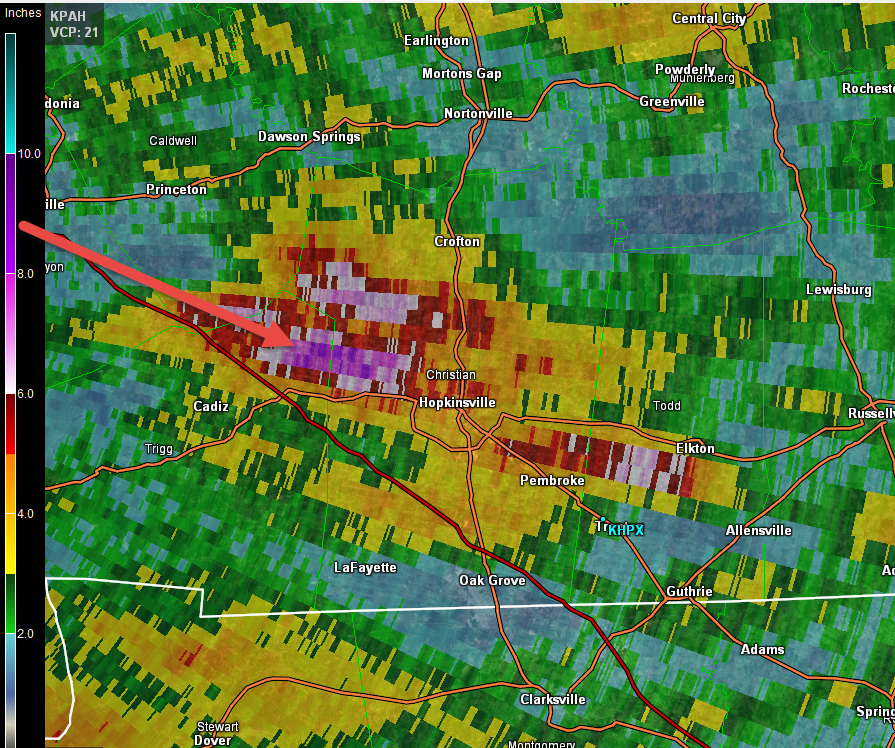
Here are some radar indicated rain maps. First, check out the Hopkinsville, KY region. Wow. Some very big totals. I have received some reports of more than 6.5″ of rain in rain gauges. Radar estimates even more than that in a few spots.
Scale is on the left. I zoomed into the Hopkinsville region of western Kentucky.
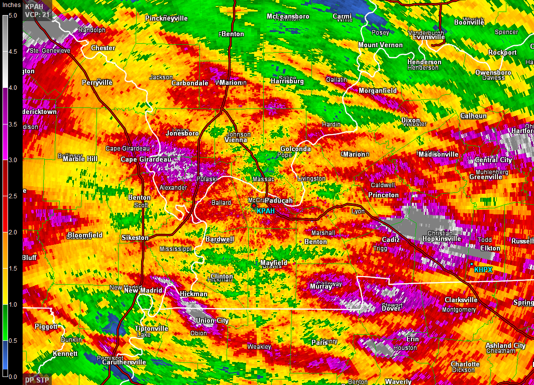
Pulling out to the regional view. The color scheme might hurt your eyes! That is a LOT of rain for our region. Obviously this is going to keep the rivers high. Additional rises are possible. See the lake and river stage forecast link further down in the blog.
Notice the patches of higher totals in red, pink, and white/gray. This is where training of storms occurred. Training of thunderstorms can cause very large rainfall totals in short periods of time. Thus, the flash flooding that has occurred in some of our counties.
Weekend Outlook:
For Friday night…showers and thunderstorms likely this evening over the region. Should diminish later tonight. Heavy rain a good bet for whoever ends up under a storm.
The good news is that the lower level winds and the front that has been over our region will weaken on Saturday and Sunday. This will leave a diffuse boundary near the Kentucky and Tennessee state line. A few showers and storms will undoubtedly pop up along this boundary. But, I am not expecting widespread thunderstorms like the last few days.
If you have outdoor plans then throw a rain jacket in to the car and an umbrella. A popup storm could move in and out of an area. But, it should not last long.
Where storms form there would be a chance for frequent lightning, heavy rain, and gusty winds. The severe weather risk for the weekend is tiny. More concerned about those heavy downpours.
Highs will be in the 80’s each day with lows mostly in the 68 to 72 degree range. Winds should remain fairly light.

If you have been reading the blog then you would have known this pattern was coming over a MONTH ago! That is a long range forecast. Using a blend of techniques, including the long range cycle theory…it is sometimes possible to nail a pattern several weeks into the future (even a month or more). It isn’t a perfect formula. For example…June was supposed to bring wetter than normal. That happened for many locations. But, temperatures ended up higher than I expected.
Temperatures will remain below normal. The first week of July will go down as below normal in the high temperature department. A bit harder at night to dip below normal, because of the wet ground conditions. But, needless to say…the pattern has been northwest flow for awhile now. That almost always means below normal temperatures and above normal precipitation (in the summer)
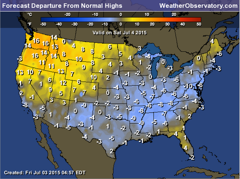
Here are the temperature anomalies for Saturday. How many degrees below normal will high temperatures be?

This section of the blog is speculative forecast information. Because it is past the range of what meteorologists can forecast accurately, it should be considered speculation. Anything past day 5 is considered a long range forecast.
Highlights
1. Another cold front arrives next week with more high QPF (heavy rain) events possible
2. River flooding concerns
Another cold front will sag back into our region next week. The timing of this front will be key to our next round of potentially heavy rain. Obviously we don’t need more heavy rain. This is a concern. Monitor updates as we move forward.
Right now, subject to changes…it appears the best chance for some heavy rain would be around Tuesday and Wednesday.
Monday should bring 20% chance for storms. Then increasing those chances by Tuesday night into Wednesday night/Thursday. Likely chances at that point. Heavy rain a good bet for some of our counties, once again.
Temperatures will remain mostly below normal next week. There are some signs we might be near normal on Monday. Once the front moves back into the region then temperatures will fall again to below normal (daytime highs). Overnight lows might be tougher to push below normal because of wet ground conditions.
The trough is winning. For now. That means less extreme heat.
River flooding continues to be an issue in our region. Recent heavy rainfall isn’t helping our cause. More heavy rain could cause additional problems.
Historically a pattern like this means multiple rounds of thunderstorms. Some storms could be heavy. I have concerns that the rivers are so high. This will need to be monitored.
Radars
WEATHER RADAR PAGE – Click here —

I also set up a storm tracking page with additional links (use during active weather for quick reference)
Storm Tracking Tool Page
Don’t forget to support our sponsors!

How much precipitation should we expect over the next few days?
As we enter the late spring and summer months, keep in mind that slow moving thunderstorms can always produce locally heavy rainfall totals. This is no secret to all of you who are farmers. Your neighbors could pick up 1″ of rain from a thunderstorm, meanwhile you are sitting on dry ground. Forecasting exact rainfall totals during this time of the year can be tricky, at best.
Saturday and Sunday rain chances will be more scattered than recent days. Rainfall totals will vary greatly over our region. Many areas will remain dry on Saturday and Sunday. a few spots will pick up a heavy downpour.
Another widespread rain event is likely next week.

Can we expect severe thunderstorms over the next 24 to 48 hours? Remember that a severe thunderstorm is defined as a thunderstorm that produces 58 mph winds or higher, quarter size hail or larger, and/or a tornado.
Thunderstorm threat level is a ONE/TWO for Friday night through Sunday.
.
Saturday Severe Weather Outlook – A few thunderstorms possible, but mostly below severe levels.
Sunday Severe Weather Outlook – A few thunderstorms possible, but mostly below severe levels.
Monday Severe Weather Outlook – A scattered storm possible. Not forecasting severe storms.
Tuesday Severe Weather Outlook – Monitor updates
Wednesday Severe Weather Outlook – Monitor updates
Thursday Severe Weather Outlook – Severe weather is not anticipated


Recent heavy rains will mean that rivers will remain high for some time to come. Fast moving water can quickly sweep people off their feet. Use care while camping. Especially children.
Avoid flooded roadways.
Lightning, as always.

Here are the current river stage forecasts. You can click your state and then the dot for your location. It will bring up the full forecast and hydrograph.
Click Here For River Stage Forecasts…
Here are some current forecast hydrographs. These will be updated each day with new information.


Smithland Lock and Dam

Paducah, Kentucky Forecast Stage

Cairo, Illinois

Cape Girardeau, Missouri
Current Temperatures Around The Local Area


We have regional radars and local city radars – if a radar does not seem to be updating then try another one. Occasional browsers need their cache cleared. You may also try restarting your browser. That usually fixes the problem. Occasionally we do have a radar go down. That is why I have duplicates. Thus, if one fails then try another one.
If you have any problems then please send me an email beaudodson@usawx.com
WEATHER RADAR PAGE – Click here —
We also have a new national interactive radar – you can view that radar by clicking here.
Local interactive city radars include St Louis, Mt Vernon, Evansville, Poplar Bluff, Cape Girardeau, Marion, Paducah, Hopkinsville, Memphis, Nashville, Dyersburg, and all of eastern Kentucky – these are interactive radars. Local city radars – click here
NOTE: Occasionally you will see ground clutter on the radar (these are false echoes). Normally they show up close to the radar sites – including Paducah.

Regional Radar – Click on radar to take you our full radar page.


Regional Radar

Live Lightning Data – zoom and pan: Click here
Live Lightning Data with sound (click the sound button on the left side of the page): Click here
I also set up a storm tracking page with additional links (use during active weather for quick reference)
Storm Tracking Tool Page
![]()
Current WARNINGS (a warning means take action now). Click on your county to drill down to the latest warning information. Keep in mind that there can be a 2-3 minute delay in the updated warning information.
I strongly encourage you to use a NOAA Weather Radio or warning cell phone app for the most up to date warning information. Nothing is faster than a NOAA weather radio.


Color shaded counties are under some type of watch, warning, advisory, or special weather statement. Click your county to view the latest information.

Missouri Warnings

Illinois Warnings

Kentucky Warnings

Here is the official 6-10 day and 8-14 day temperature and precipitation outlook. Check the date stamp at the top of each image (so you understand the time frame).
The forecast maps below are issued by the Weather Prediction Center (NOAA).


The latest 8-14 day temperature and precipitation outlook. Note the dates are at the top of the image. These maps DO NOT tell you how high or low temperatures or precipitation will be. They simply give you the probability as to whether temperatures or precipitation will be above or below normal.


Who do you trust for your weather information and who holds them accountable?
I have studied weather in our region since the late 1970’s. I have 37 years of experience in observing our regions weather patterns. My degree is in Broadcast Meteorology from Mississippi State University and an Associate of Science (AS). I am currently working on my Bachelor’s Degree in Geoscience. Just need to finish two Spanish classes!
I am a member of the American Meteorological Society. I am a NOAA Weather-Ready Nation Ambassador. And, I am the Meteorologist for McCracken County Emergency Management.
I own and operate the Southern Illinois Weather Observatory.
There is a lot of noise on the internet. A lot of weather maps are posted without explanation. Over time you should learn who to trust for your weather information.
My forecast philosophy is simple and straight forward.
- Communicate in simple terms
- To be as accurate as possible within a reasonable time frame before an event
- Interact with you on Twitter, Facebook, and the blog
- Minimize the “hype” that you might see on television or through other weather sources
- Push you towards utilizing wall-to-wall LOCAL TV coverage during severe weather events
I am a recipient of the Mark Trail Award, WPSD Six Who Make A Difference Award, Kentucky Colonel, and the Caesar J. Fiamma” Award from the American Red Cross. In 2009 I was presented with the Kentucky Office of Highway Safety Award. I was recognized by the Kentucky House of Representatives for my service to the State of Kentucky leading up to several winter storms and severe weather outbreaks.
If you click on the image below you can read the Kentucky House of Representatives Resolution.

I am also President of the Shadow Angel Foundation which serves portions of western Kentucky and southern Illinois.
Many of my graphics are from www.weatherbell.com – a great resource for weather data, model data, and more


You can sign up for my AWARE email by clicking here I typically send out AWARE emails before severe weather, winter storms, or other active weather situations. I do not email watches or warnings. The emails are a basic “heads up” concerning incoming weather conditions.