.
Click one of the links below to take you directly to that section
![]()
![]()
![]()
![]()
![]()
![]()
![]()
Do you have any suggestions or comments? Email me at beaudodson@usawx.com
.
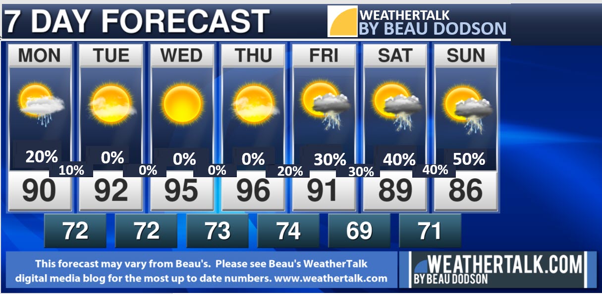
7-day forecast for southeast Missouri, southern Illinois, western Kentucky, and western Tennessee.
This is a BLEND for the region. See the detailed region by region forecast further down in this post.
THE FORECAST IS GOING TO VARY FROM LOCATON TO LOCATION.
SEE THE DAILY DETAILS (REGION BY REGION) FURTHER DOWN IN THIS BLOG UPDATE.
48-hour forecast


.

.
Monday to Monday
1. Is lightning in the forecast? Yes. A few lightning strikes today. Mainly along the MO/AR and KY/TN State line area. Chances Tuesday and Wednesday are very low. Chances increase again Friday into the weekend.
2. Are severe thunderstorms in the forecast? Monitor. I will monitor next weekend.
The NWS officially defines a severe thunderstorm as a storm with 58 mph wind or greater, 1″ hail or larger, and/or tornadoes
3. Is flash flooding in the forecast? Monitor. I am monitoring locally heavy rain chances this coming weekend with several clusters of thunderstorms.
Slow moving thunderstorms could produce one to two inches of rain in less than 30-minutes.
4. Will the heat index top 100 degrees? Yes. Each day through Friday. Heat index values of 100 to 105 are likely with pockets of 105 to 110 Tuesday and Wednesday.
5. Will the wind chill dip below 10 degrees above zero? No.
6. Will there be accumulating snow and ice in the forecast? No.
.

.
July 26, 2021
How confident am I that this days forecast will verify? High confidence
Monday Forecast: Partly cloudy. Hot and muggy. A chance of showers and thunderstorms.
What is the chance of precipitation? MO Bootheel ~ 50% / SE MO ~ 30% / I-64 Corridor South IL ~ 20% / South IL ~ 30% / West KY ~ 40% / NW KY (near Indiana border) ~ 40% / NW TN ~ 40%
Coverage of precipitation: Scattered
Timing of the rain: Any given point of time.
Temperature range: MO Bootheel 90° to 92° / SE MO 90° to 92° / South IL 90° to 92° / Northwest KY (near Indiana border) 90° to 92° / West KY 90° to 92° / NW TN 90° to 94°
Wind direction and speed: Northeast at 5 to 10 mph
Wind chill or heat index (feels like) temperature forecast: 96° to 102°
What impacts are anticipated from the weather? Wet roadways. Lightning. Locally heavy downpours where thunderstorms occur.
Should I cancel my outdoor plans? No. Check the radars.
UV Index: 10. Very high
Sunrise: 5:55 AM
Sunset: 8:08 PM
.
Monday night Forecast: Partly cloudy. A slight chance of a shower or thunderstorm. Warm and humid.
What is the chance of precipitation? MO Bootheel ~ 20% / SE MO ~ 10% / I-64 Corridor South IL ~ 10% / South IL ~ 10% / West KY ~ 10% / NW KY (near Indiana border) ~ 10% / NW TN ~ 20%
Coverage of precipitation: Isolated
Timing of the rain: Before midnight.
Temperature range: MO Bootheel 70° to 74° / SE MO 70° to 74° / South IL 70° to 74° / Northwest KY (near Indiana border) 70° to 74° / West KY 70° to 74° / NW TN 70° to 74°
Wind direction and speed: East at 5 mph
Wind chill or heat index (feels like) temperature forecast: 70° to 75°
What impacts are anticipated from the weather? Isolated wet roadways. Lightning.
Should I cancel my outdoor plans? No. Check the weather radars.
Moonrise: 10:17 PM
Moonset: 8:30 AM
The phase of the moon: Waning Gibbous
.
July 27, 2021
How confident am I that this days forecast will verify? High confidence
Tuesday Forecast: Mostly sunny. Hot and muggy. A slight chance of showers and thunderstorms over our southern counties.
What is the chance of precipitation? MO Bootheel ~ 20% / SE MO ~ 0% / I-64 Corridor South IL ~ 0% / South IL ~ 0% / West KY ~ 10% / NW KY (near Indiana border) ~ 0% / NW TN ~ 20%
Coverage of precipitation: None to isolated
Timing of the rain: Any given point of time
Temperature range: MO Bootheel 90° to 95° / SE MO 90° to 95° / South IL 90° to 95° / Northwest KY (near Indiana border) 90° to 95° / West KY 90° to 95° / NW TN 90° to 95°
Wind direction and speed: Northeast at 5 to 10 mph
Wind chill or heat index (feels like) temperature forecast: 100° to 105° locally higher depending on clouds
What impacts are anticipated from the weather? Oppressive heat and humidity/dew points. Isolated wet roadways and lightning.
Should I cancel my outdoor plans? No. Check the radars.
UV Index: 10. Very high
Sunrise: 5:56 AM
Sunset: 8:07 PM
.
Tuesday night Forecast: Mostly clear. Warm and humid.
What is the chance of precipitation? MO Bootheel ~ 0% / SE MO ~ 0% / I-64 Corridor South IL ~ 0% / South IL ~ 0% / West KY ~ 0% / NW KY (near Indiana border) ~ 0% / NW TN ~ 0%
Coverage of precipitation: None
Timing of the rain:
Temperature range: MO Bootheel 72° to 74° / SE MO 72° to 74° / South IL 72° to 74° / Northwest KY (near Indiana border) 72° to 74° / West KY 72° to 74° / NW TN 72° to 74°
Wind direction and speed: Light wind.
Wind chill or heat index (feels like) temperature forecast: 72° to 75°
What impacts are anticipated from the weather? None
Should I cancel my outdoor plans? No.
Moonrise: 10:45 PM
Moonset: 9:35 AM
The phase of the moon: Waning Gibbous
.
July 28, 2021
How confident am I that this days forecast will verify? High confidence
Wednesday Forecast: Mostly sunny. Hot and muggy.
What is the chance of precipitation? MO Bootheel ~ 0% / SE MO ~ 0% / I-64 Corridor South IL ~ 0% / South IL ~ 0% / West KY ~ 0% / NW KY (near Indiana border) ~ 0% / NW TN ~ 0%
Coverage of precipitation: None
Timing of the rain:
Temperature range: MO Bootheel 92° to 95° / SE MO 92° to 95° / South IL 92° to 95° / Northwest KY (near Indiana border) 92° to 95° / West KY 92° to 95° / NW TN 92° to 95°
Wind direction and speed: Southeast 4 to 8 mph
Wind chill or heat index (feels like) temperature forecast: 102° to 106° locally higher
What impacts are anticipated from the weather? High heat index values.
Should I cancel my outdoor plans? No.
UV Index: 10. Very high
Sunrise: 5:57 AM
Sunset: 8:06 PM
.
Wednesday night Forecast: Mostly clear warm and humid.
What is the chance of precipitation? MO Bootheel ~ 0% / SE MO ~ 0% / I-64 Corridor South IL ~ 0% / South IL ~ 0% / West KY ~ 0% / NW KY (near Indiana border) ~ 0% / NW TN ~ 0%
Coverage of precipitation: Widely scattered
Timing of the rain: Mostly before midnight.
Temperature range: MO Bootheel 72° to 74° / SE MO 72° to 74° / South IL 72° to 74° / Northwest KY (near Indiana border) 72° to 74° / West KY 72° to 74° / NW TN 72° to 74°
Wind direction and speed: South southeast 5 mph
Wind chill or heat index (feels like) temperature forecast: 72° to 75°
What impacts are anticipated from the weather? None
Should I cancel my outdoor plans? No.
Moonrise: 11:10 PM
Moonset: 10:38 AM
The phase of the moon: Waning Gibbous
.
July 29, 2021
How confident am I that this days forecast will verify? Medium confidence
Thursday Forecast: Mostly sunny. Hot and muggy. A slight chance of thunderstorms.
What is the chance of precipitation? MO Bootheel ~ 10% / SE MO ~ 10% / I-64 Corridor South IL ~ 10% / South IL ~ 10% / West KY ~ 10% / NW KY (near Indiana border) ~ 10% / NW TN ~ 10%
Coverage of precipitation: None to isolated
Timing of the rain: Mainly the PM hours
Temperature range: MO Bootheel 92° to 95° / SE MO 92° to 95° / South IL 92° to 95° / Northwest KY (near Indiana border) 92° to 95° / West KY 92° to 95° / NW TN 92° to 95°
Wind direction and speed: South southwest 6 to 12 mph
Wind chill or heat index (feels like) temperature forecast: 100° to 106° locally higher
What impacts are anticipated from the weather? Isolated wet roadways and lightning.
Should I cancel my outdoor plans? No. Monitor updates.
UV Index: 10. Very high
Sunrise: 5:58 AM
Sunset: 8:06 PM
.
Thursday night Forecast: Mostly clear. Warm and humid. A slight chance of showers and thunderstorms.
What is the chance of precipitation? MO Bootheel ~ 10% / SE MO ~ 10% / I-64 Corridor South IL ~ 10% / South IL ~ 10% / West KY ~ 10% / NW KY (near Indiana border) ~ 10% / NW TN ~ 10%
Coverage of precipitation: Isolated
Timing of the rain: Any given point of time
Temperature range: MO Bootheel 72° to 74° / SE MO 72° to 74° / South IL 72° to 74° / Northwest KY (near Indiana border) 72° to 74° / West KY 72° to 74° / NW TN 72° to 74°
Wind direction and speed: West southwest 5 to 10 mph
Wind chill or heat index (feels like) temperature forecast: 72° to 75°
What impacts are anticipated from the weather? Isolated wet roadways and lightning.
Should I cancel my outdoor plans? No. Monitor updates.
Moonrise: 11:35 PM
Moonset: 11:37 AM
The phase of the moon: Waning Gibbous
.
July 30, 2021
How confident am I that this days forecast will verify? Medium confidence
Friday Forecast: I will be monitoring a cold front to our northeast. It may move into our region Friday. If so, temperatures won’t be as hot as Monday through Thursday. Mostly sunny. A slight chance of thunderstorms.
What is the chance of precipitation? MO Bootheel ~ 10% / SE MO ~ 20% / I-64 Corridor South IL ~ 20% / South IL ~ 20% / West KY ~ 20% / NW KY (near Indiana border) ~ 20% / NW TN ~ 10%
Coverage of precipitation: Widely scattered
Timing of the rain: Mainly the PM hours
Temperature range: MO Bootheel 86° to 92° / SE MO 86° to 92° / South IL 86° to 92° / Northwest KY (near Indiana border) 86° to 92° / West KY 86° to 92° / NW TN 86° to 92°
Wind direction and speed: South southwest 6 to 12 mph
Wind chill or heat index (feels like) temperature forecast: 90° to 95°
What impacts are anticipated from the weather? Wet roadways and lightning.
Should I cancel my outdoor plans? No. Monitor updates.
UV Index: 10. Very high
Sunrise: 5:58 AM
Sunset: 8:06 PM
.
Friday night Forecast: Mostly clear. Warm and humid. A chance of showers and thunderstorms.
What is the chance of precipitation? MO Bootheel ~ 20% / SE MO ~ 20% / I-64 Corridor South IL ~ 20% / South IL ~ 20% / West KY ~ 20% / NW KY (near Indiana border) ~ 20% / NW TN ~ 20%
Coverage of precipitation: Widely scattered
Timing of the rain: Any given point of time
Temperature range: MO Bootheel 70° to 74° / SE MO 70° to 74° / South IL 70° to 74° / Northwest KY (near Indiana border) 70° to 74° / West KY 70° to 74° / NW TN 70° to 74°
Wind direction and speed: West southwest 5 to 10 mph
Wind chill or heat index (feels like) temperature forecast: 70° to 75°
What impacts are anticipated from the weather? Isolated wet roadways and lightning.
Should I cancel my outdoor plans? No. Monitor updates.
Moonrise:
Moonset: 12:36 PM
The phase of the moon: Waning Gibbous
.
July 31, 2021
How confident am I that this days forecast will verify? LOW confidence
Saturday Forecast: Partly sunny. Hot and humid. A chance of showers and thunderstorms.
What is the chance of precipitation? MO Bootheel ~ 30% to 40% / SE MO ~ 30% to 40% / I-64 Corridor South IL ~ 30% to 40% / South IL ~ 30% to 40% / West KY ~ 30% to 40% / NW KY (near Indiana border) ~ 30% to 40% / NW TN ~ 30% to 40%
Coverage of precipitation: Scattered
Timing of the rain:
Temperature range: MO Bootheel 86° to 92° / SE MO 86° to 92° / South IL 86° to 92° / Northwest KY (near Indiana border) 86° to 92° / West KY 86° to 92° / NW TN 86° to 92°
Wind direction and speed:
Wind chill or heat index (feels like) temperature forecast: 100° to 106° locally higher
What impacts are anticipated from the weather? Wet roadways and lightning.
Should I cancel my outdoor plans? No. Monitor updates.
UV Index: 10. Very high
Sunrise: 5:59 AM
Sunset: 8:04 PM
.
Saturday night Forecast: Partly cloudy. Warm and humid. A chance of showers and thunderstorms.
What is the chance of precipitation? MO Bootheel ~ 30% / SE MO ~ 30% / I-64 Corridor South IL ~ 30% / South IL ~ 30% / West KY ~ 30% / NW KY (near Indiana border) ~ 30% / NW TN ~ 30%
Coverage of precipitation: Scattered
Timing of the rain: Any given point of time
Temperature range: MO Bootheel 72° to 74° / SE MO 72° to 74° / South IL 72° to 74° / Northwest KY (near Indiana border) 72° to 74° / West KY 72° to 74° / NW TN 72° to 74°
Wind direction and speed: West southwest 5 to 10 mph
Wind chill or heat index (feels like) temperature forecast: 72° to 75°
What impacts are anticipated from the weather? Wet roadways and lightning.
Should I cancel my outdoor plans? No. Monitor updates.
Moonrise: 12:01 AM
Moonset: 1:34 PM
The phase of the moon: Last quarter
.
August 1st, 2021
How confident am I that this days forecast will verify? LOW confidence
Sunday Forecast: Partly sunny. Hot and humid. A chance of showers and thunderstorms.
What is the chance of precipitation? MO Bootheel ~ 40% to 50% / SE MO ~ 40% to 50% / I-64 Corridor South IL ~ 40% to 50% / South IL ~ 40% to 50% / West KY ~ 40% to 50% / NW KY (near Indiana border) ~ 40% to 50% / NW TN ~ 40% to 50%
Coverage of precipitation: Scattered to perhaps numerous
Timing of the rain: Any given point of time
Temperature range: MO Bootheel 86° to 92° / SE MO 86° to 92° / South IL 86° to 92° / Northwest KY (near Indiana border) 86° to 92° / West KY 86° to 92° / NW TN 86° to 92°
Wind direction and speed:
Wind chill or heat index (feels like) temperature forecast: 100° to 106° locally higher
What impacts are anticipated from the weather? Wet roadways and lightning.
Should I cancel my outdoor plans? No. Monitor updates.
UV Index: 8. Very high
Sunrise: 6:00 AM
Sunset: 8:03 PM
.
Sunday night Forecast: Partly cloudy. Warm and humid. A chance of showers and thunderstorms.
What is the chance of precipitation? MO Bootheel ~ 30% / SE MO ~ 30% / I-64 Corridor South IL ~ 30% / South IL ~ 30% / West KY ~ 30% / NW KY (near Indiana border) ~ 30% / NW TN ~ 30%
Coverage of precipitation: Scattered
Timing of the rain: Any given point of time
Temperature range: MO Bootheel 72° to 74° / SE MO 72° to 74° / South IL 72° to 74° / Northwest KY (near Indiana border) 72° to 74° / West KY 72° to 74° / NW TN 72° to 74°
Wind direction and speed: West southwest 5 to 10 mph
Wind chill or heat index (feels like) temperature forecast: 72° to 75°
What impacts are anticipated from the weather? Wet roadways and lightning.
Should I cancel my outdoor plans? No. Monitor updates.
Moonrise: 12:28 AM
Moonset: 2:33 PM
The phase of the moon: Waning Crescent
.
.

These graphics are changed out between 10:00 AM and 11:00 AM (Monday through Friday only)
Double click on the images to enlarge them.
Click the images to enlarge them.
These five graphics are from Friday. New graphics will be posted after 10:30 AM Monday.
![]()
![]()
Graphic-cast
Click here if you would like to return to the top of the page.
Illinois
Check my handwritten forecast towards the top of the page. These are auto-generated. My actual forecast may vary from these.

.
Kentucky
Check my handwritten forecast towards the top of the page. These are auto-generated. My actual forecast may vary from these.


.

.

.
.Tennessee
Check my handwritten forecast towards the top of the page. These are auto-generated. My actual forecast may vary from these.

.
.
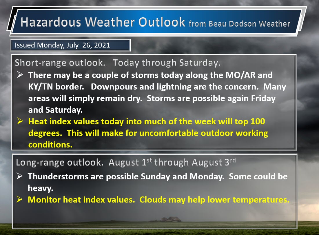
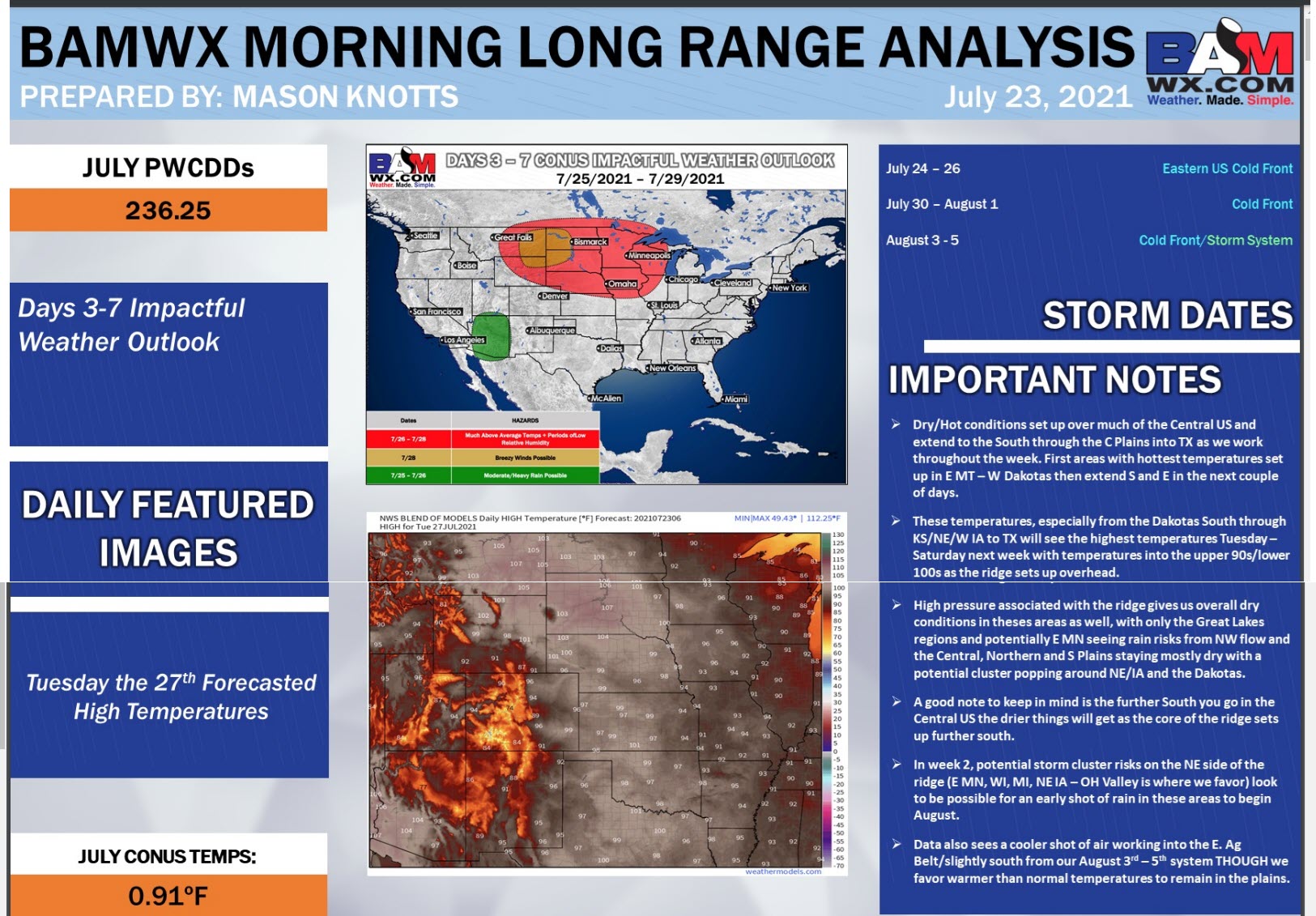
Today through July 30th: Widespread severe weather is not anticipated. A few intense storms are possible towards the end of the week.
I am watching next Saturday and Sunday. There are some indications that some stronger storms would be possible.

.
Today’s outlook (below).
Light green is where thunderstorms may occur but should be below severe levels.
Dark green is a level one risk. Yellow is a level two risk. Orange is a level three (enhanced) risk. Red is a level four (moderate) risk. Pink is a level five (high) risk.
One is the lowest risk. Five is the highest risk.
A severe storm is one that produces 58 mph wind or higher, quarter size hail, and/or a tornado.
The tan states are simply a region that SPC outlined on this particular map. Just ignore that.

The black outline is our local area.

.
Tomorrow’s severe weather outlook.

.

.
The images below are from the WPC. Their totals are a bit lower than our current forecast. I wanted to show you the comparison.
24-hour precipitation outlook.
.
 .
.
48-hour precipitation outlook.
.
.
72-hour precipitation outlook.
.
.
![]()
![]()

Weather Discussion
-
- A hot week ahead of us.
- A few thunderstorms.
.
Weather advice:
The primary weather concern over the coming days will be the heat and dew points. Oppressive, at times. Use care.
.
Weather Discussion
I have a radio talk show Monday morning. I am going to go ahead and update the blog today (Sunday). I will update a few of the graphics Monday morning, as well.
I will update the videos and the long-range portion of the blog late Monday morning.
A couple of weather stories over the coming days.
We have a cold front near the region today (Sunday). The front will help pop several showers and thunderstorms. Where thunderstorms develop, they could produce torrential downpours, frequent lightning, and gusty wind.
Some storms are possible Monday, as well. For now, it appears any thunderstorm activity Tuesday and Wednesday would be none to isolated.
The bigger weather story will be the heat and dew points. Highs each day will range from 90 to 95. Tuesday and Wednesday may end up being the hottest days with widespread middle 90s.
Dew points in the 70s will make it feel like air you wear. Heat index values of 100 to 105+ will not be uncommon over the coming days. The NWS may have to issue some heat advisory products. Either way, it will be hot.
Use care if you must work outside. Know the symptoms of heat stroke.
.
I am watching a cold front Thursday into the weekend. This boundary will approach from the north/northeast. Perhaps a backdoor cold front.
That could bring some relief to the region. It would mean more clouds and higher shower/thunderstorm chances. Perhaps some thunderstorm complexes (MCS’s).
There remain some questions about the placement of the cold front. I will monitor trends. Peak thunderstorm chances may be Saturday and Sunday if the GFS model is correct. The EC leans towards Sunday (August 1st) as the highest chance of thunderstorm activity. Something to monitor over the coming days.
Any thunderstorms that form could produce heavy rain. It is summer, after all.
.

Click here if you would like to return to the top of the page.
Again, as a reminder, these are models. They are never 100% accurate. Take the general idea from them.
What should I take from these?
- The general idea and not specifics. Models usually do well with the generalities.
- The time-stamp is located in the upper left corner.
- The EC European weather model is in Zulu time.
.
What am I looking at?
You are looking at different models. Meteorologists use many different models to forecast the weather. All models are wrong. Some are more wrong than others. Meteorologists have to make a forecast based on the guidance/models.
I show you these so you can see what the different models are showing as far as precipitation. If most of the models agree, then the confidence in the final weather forecast increases.
You can see my final forecast at the top of the page.
.
This animation is the Storm Prediction Center WRF model.
This animation shows you what radar might look like as the next system pulls through the region. It is a future-cast radar.
Time-stamp upper left. Click the animation to enlarge it.
.
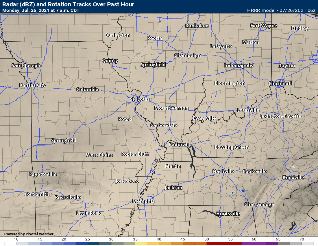
This animation is the Hrrr short-range model.
This animation shows you what radar might look like as the next system pulls through the region. It is a future-cast radar.
Time-stamp upper left. Click the animation to enlarge it.
.
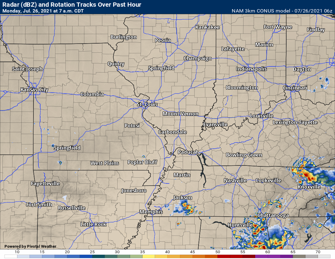
.This animation is the higher-resolution 3K NAM American Model.
This animation shows you what radar might look like as the next system pulls through the region. It is a future-cast radar.
Time-stamp upper left. Click the animation to enlarge it.
.
This next animation is the lower-resolution NAM American Model.
This animation shows you what radar might look like as the system pulls through the region. It is a future-cast radar.
Time-stamp upper left. Click the animation to enlarge it.
.
This next animation is the GFS American Model.
This animation shows you what radar might look like as the system pulls through the region. It is a future-cast radar.
Time-stamp upper left. Click the animation to enlarge it.
Longer range GFS
.
This next animation is the EC European Weather model.
This animation shows you what radar might look like as the system pulls through the region. It is a future-cast radar.
Time-stamp upper left. Click the animation to enlarge it.
Long range
.
.![]()
.

.
Click here if you would like to return to the top of the page.
.
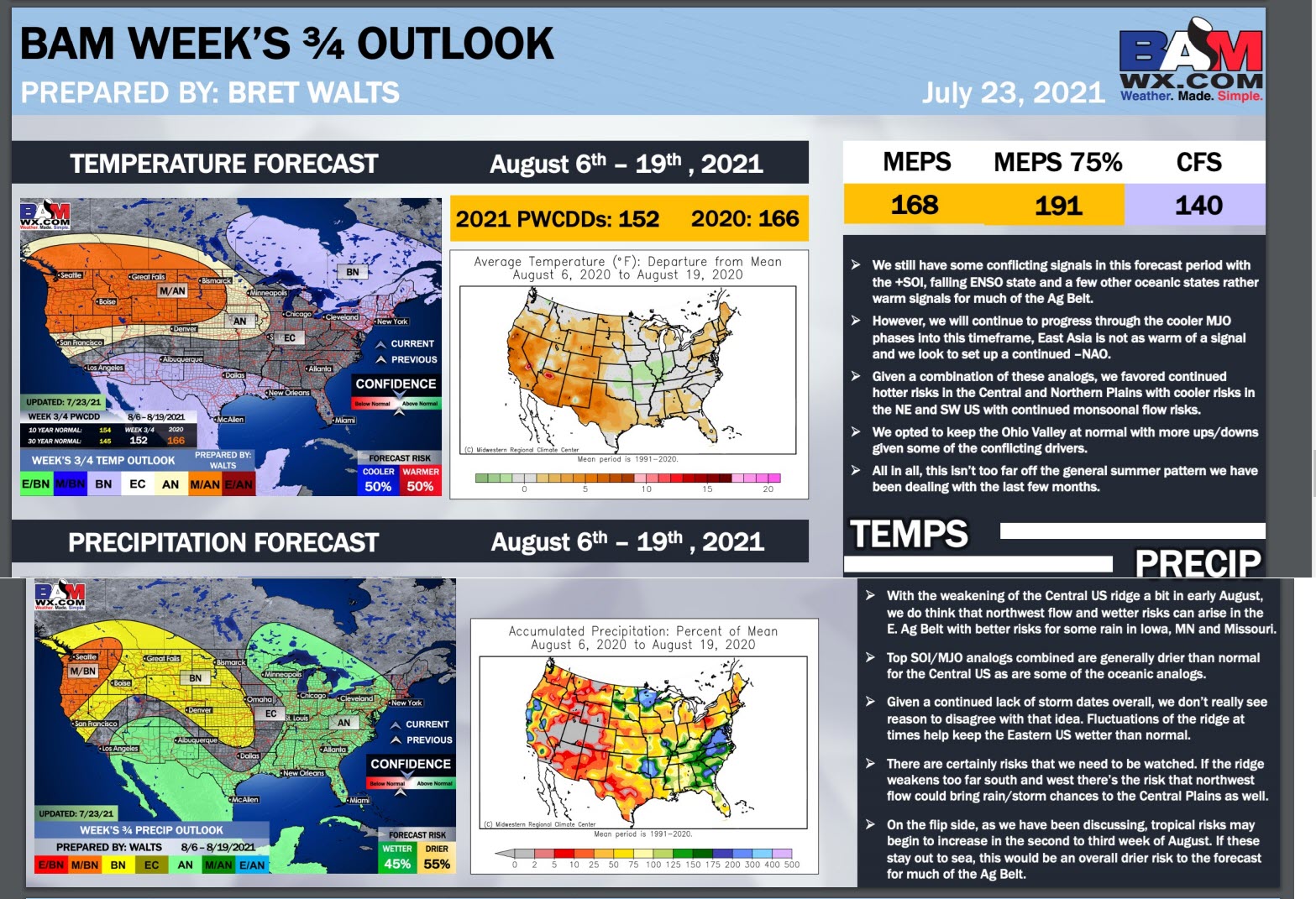
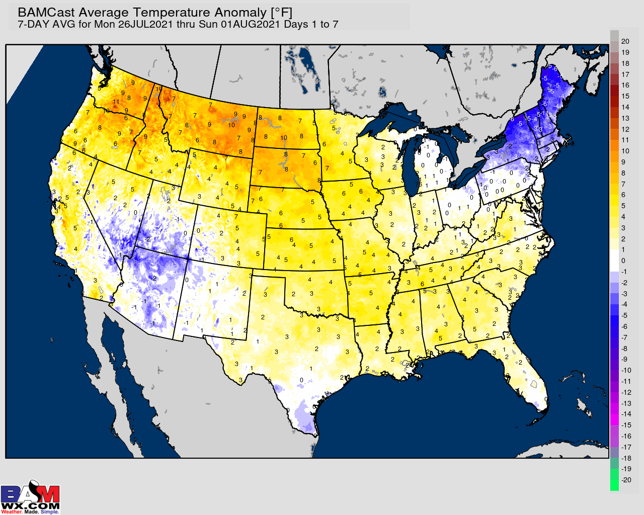
Average high temperatures for this time of the year are around 88 degrees.
Average low temperatures for this time of the year are around 68 degrees.
Average precipitation during this time period ranges from 1.00″ to 1.20″
Yellow and orange colors are above average temperatures. Red is much above average. Light blue and blue are below-average temperatures. Green to purple colors represents much below-average temperatures.
This outlook covers July 26th through August 1st
Click on the image to expand it.
.
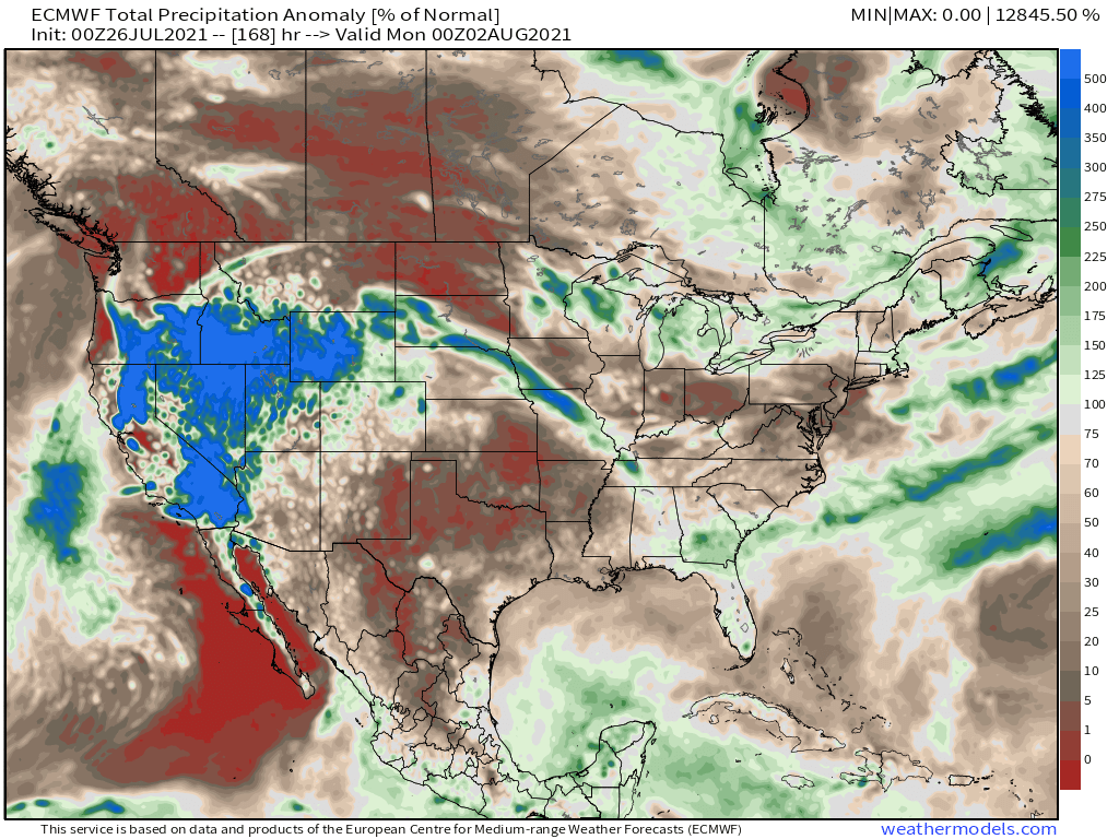
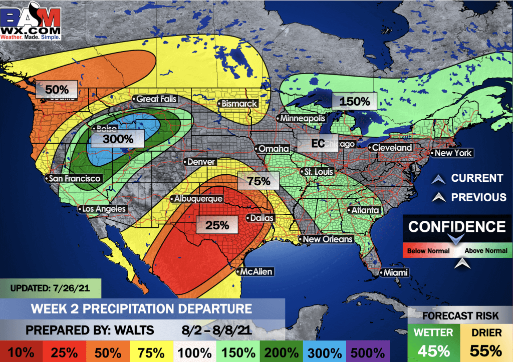
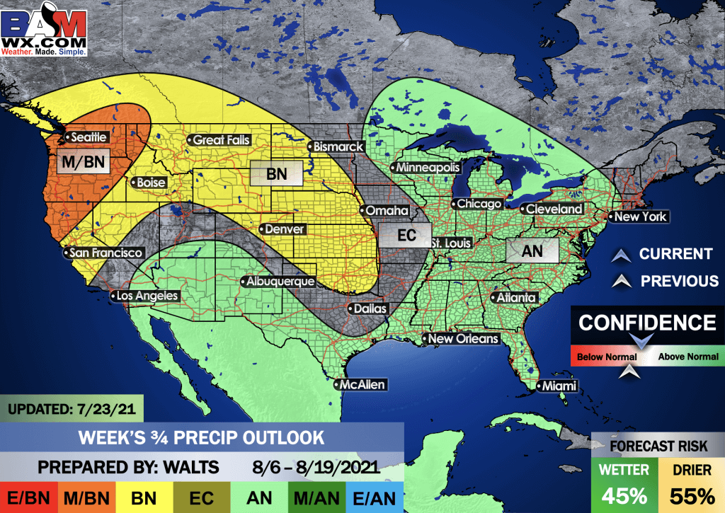
The precipitation forecast is PERCENT OF AVERAGE. Brown is below average. Green is above average. Blue is much above average.

Average low temperatures for this time of the year are around 68 degrees
Average precipitation during this time period ranges from 1.00″ to 1.30″
.
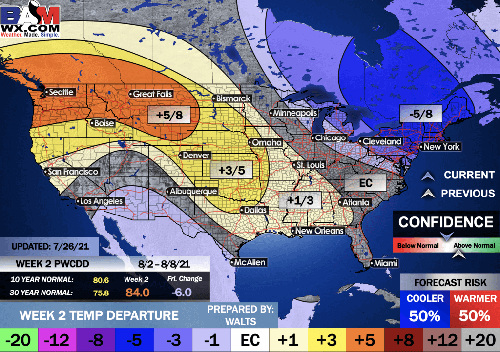
This outlook covers August 2nd through August 8th
Click on the image to expand it.
The precipitation forecast is PERCENT OF AVERAGE. Brown is below average. Green is above average. Blue is much above average.
.

EC = Equal chances of above or below average
BN= Below average
M/BN = Much below average
AN = Above average
M/AN = Much above average
E/AN = Extremely above average
Average low temperatures for this time of the year are around 68 degrees
Average precipitation during this time period ranges from 1.80″ to 2.10″
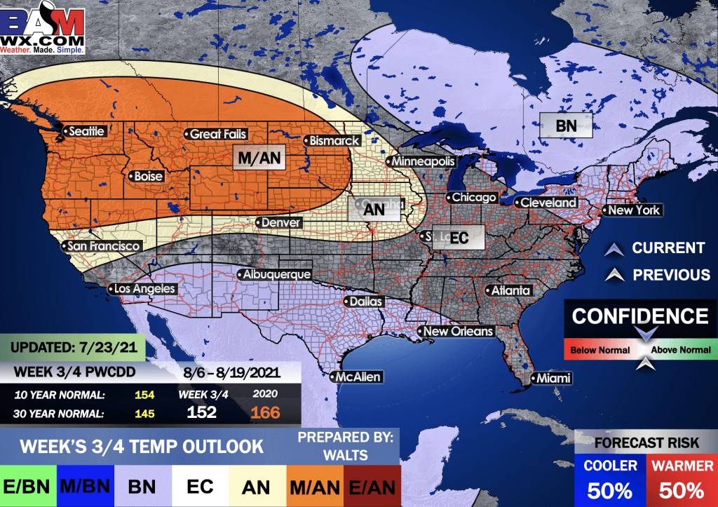
This outlook covers August 6th through August 19th
.
Precipitation outlook
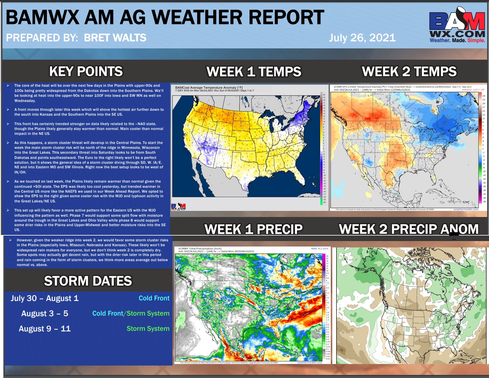
LONG RANGE DISCUSSION
Key Points: This was written by the BAMwx team. I don’t edit it.
Temperature departures
Preliminary outlooks
E/BN extremely below normal.
M/BN is much below normal
EC equal chances
AN above normal
M/AN much above normal
E/AN extremely above normal.
July Temperature Outlook
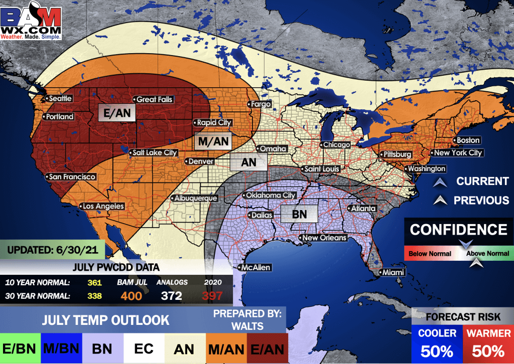
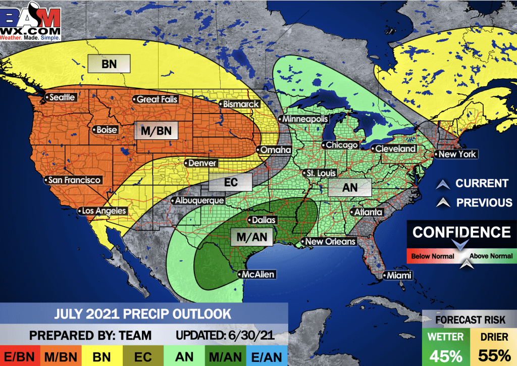
July precipitation outlook
.
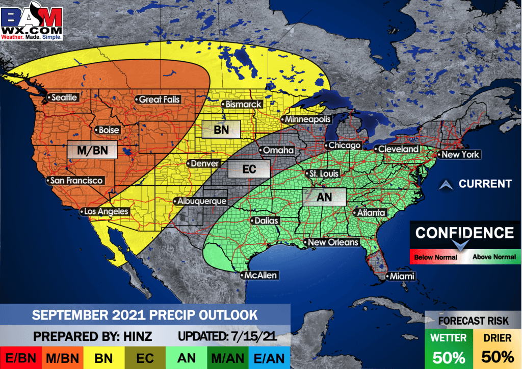
Preliminary outlooks
E/BN extremely below normal.
M/BN is much below normal
EC equal chances
AN above normal
M/AN much above normal
E/AN extremely above normal.
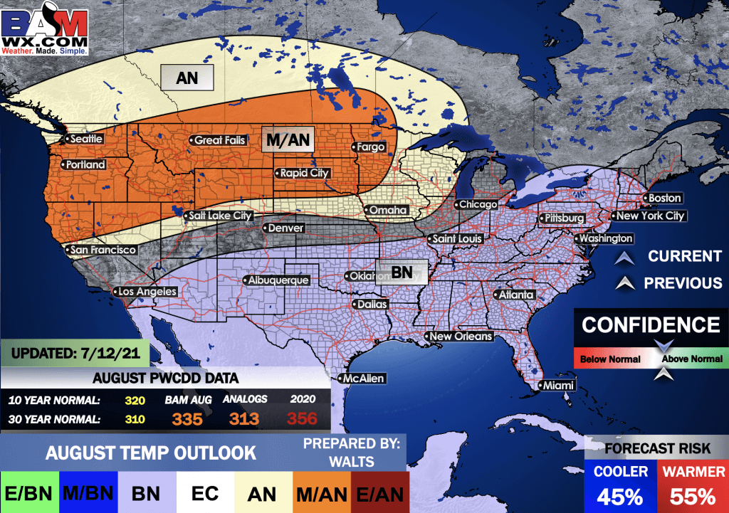
August Temperature Outlook
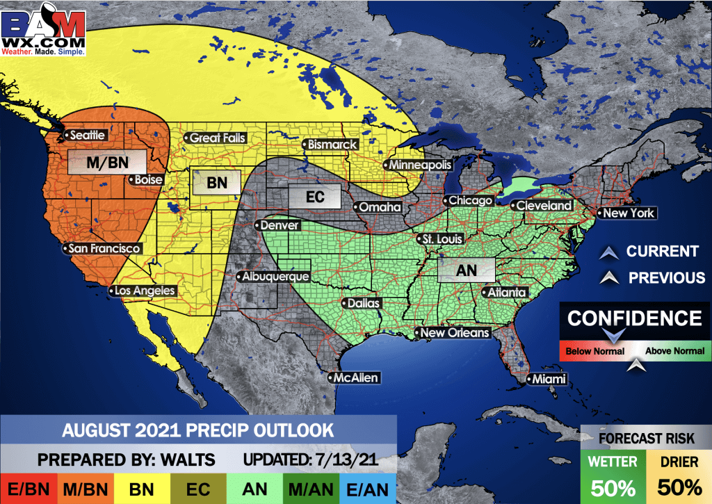
August precipitation outlook
.
Preliminary outlooks
E/BN extremely below normal.
M/BN is much below normal
EC equal chances
AN above normal
M/AN much above normal
E/AN extremely above normal.
September Temperature Outlook
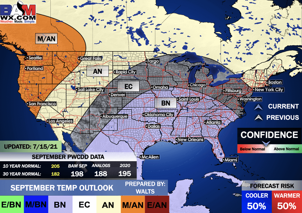
September precipitation outlook
.
Summer Outlook
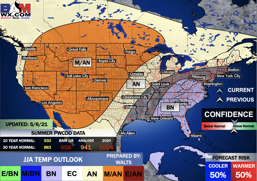
E/BN extremely below normal.
M/BN is much below normal
EC equal chances
AN above normal
M/AN much above normal
E/AN extremely above normal.
June, July, and August Temperature Outlook
.
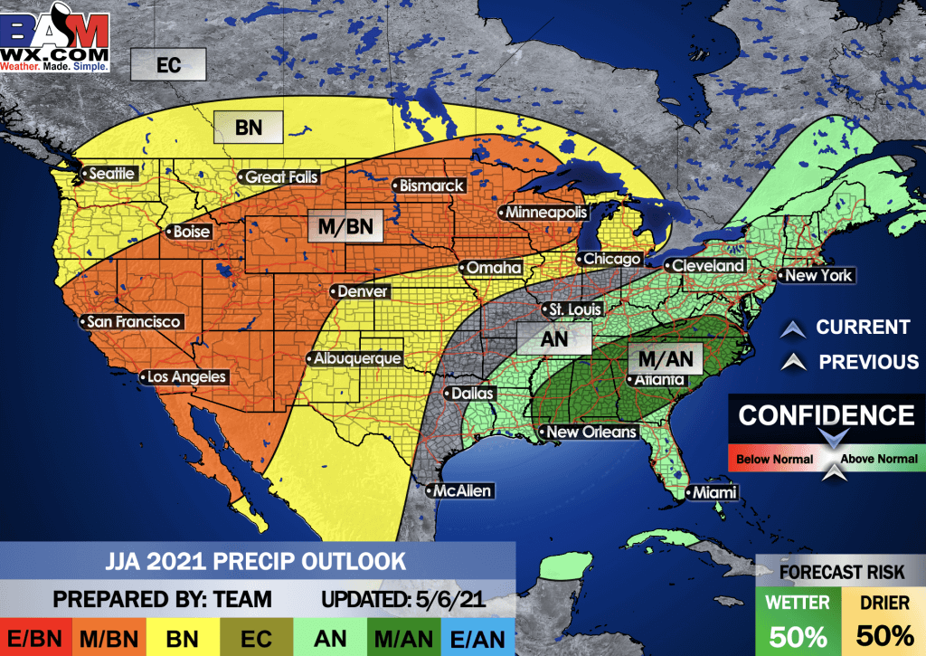
E/BN extremely below normal.
M/BN is much below normal
EC equal chances
AN above normal
M/AN much above normal
E/AN extremely above normal.
June, July, and August Precipitation Outlook
.
![]()

Great news! The videos are now found in your Weathertalk app and on the WeatherTalk website.
These are bonus videos for subscribers.
The app is for subscribers. Subscribe at www.weathertalk.com/welcome then go to your app store and search for WeatherTalk
Subscribers, PLEASE USE THE APP. ATT and Verizon are not reliable during severe weather. They are delaying text messages.
The app is under WeatherTalk in the app store.

Apple users click here

Android users click here
.

Radars and Lightning Data
Interactive-city-view radars. Clickable watches and warnings.
https://wtalk.co/B3XHASFZ
If the radar is not updating then try another one. If a radar does not appear to be refreshing then hit Ctrl F5. You may also try restarting your browser.
Backup radar site in case the above one is not working.
https://weathertalk.com/morani
Regional Radar
https://imagery.weathertalk.com/prx/RadarLoop.mp4
** NEW ** Zoom radar with chaser tracking abilities!
ZoomRadar
Lightning Data (zoom in and out of your local area)
https://wtalk.co/WJ3SN5UZ
Not working? Email me at beaudodson@usawx.com
National map of weather watches and warnings. Click here.
Storm Prediction Center. Click here.
Weather Prediction Center. Click here.
.

Live lightning data: Click here.
Real time lightning data (another one) https://map.blitzortung.org/#5.02/37.95/-86.99
Our new Zoom radar with storm chases
.
.

Interactive GOES R satellite. Track clouds. Click here.
GOES 16 slider tool. Click here.
College of Dupage satellites. Click here
.

Here are the latest local river stage forecast numbers Click Here.
Here are the latest lake stage forecast numbers for Kentucky Lake and Lake Barkley Click Here.
.
.
Find Beau on Facebook! Click the banner.


 .
.