Updates:
4 PM – the next update will be the full Weather Talk Daily update. Hope to have it finished in about an hour or so.
See other updates below.
Monday: Update 3.
3 PM Update: The CAP is holding nicely across our region. Which, is no surprise. The question continues to be what happens over the coming hours.
Time for a forecast…
A shortwave is moving into our region from Missouri. In order for a CAP to break you need a few things. Cooler air aloft moving into the region (heights falling). You need a disturbance with enough oomfff to help lift the air. When the air is lifted it can break the CAP. You need a focus point. A front or a shortwave.
We do have some of that moving in from the north. A front and a shortwave. But, the CAP is strong.
This is what I think is going to happen. This is my forecast.
Two areas of storms are forming over northern Missouri and northern Illinois. These are separate events.
The northern Illinois storms are going to start developing more rapidly over the coming 3 hours. They will blossom and start to become a line of storms. The line will then mesh together and form a squall line. Possible a bow echo event with numerous wind damage reports.
As the evening wears on we will watch radar light up over northern Illinois and eventually into part of northern Indiana.
This line will sweep southward tonight. Could be very late before it arrives in the area. It would first approach somewhere along a line from Effingham, Illinois towards Indianapolis. Then it will continue south and east. This would probably be somewhere around 7 pm and 9 pm.
Damaging winds, isolated hail reports, and a few tornadoes will be possible with this line. Frequent cloud to ground lightning. Torrential rainfall of 1-2″+ per hour under the heaviest cells.
Then the question will be whether it starts to track more southeast into Indiana or will it back build enough to cover parts of southeast Illinois (our local counties). This will need to be monitored. Could be after 8-10 pm before it would reach our northern counties in southeast Illinois. Say from Mt Vernon towards Wayne, Edward, and Wabash Counties.
Second area of concern…
Then, another area of thunderstorms will continue to develop over northern and northeast Missouri. These will start to track towards the St Louis area. I have less confidence about this storm complex and its intensity. However, the atmosphere is very unstable. If the storms can hold together over the next few hours then they would be severe.
Large hail would be more likely with those storms. Also damaging winds and possible a tornado. Frequent cloud to ground lightning is likely tonight with any storms that develop.
It might be a very late night for some of the area when it comes to storms. It is even possible that storms, some possibly severe, could be going after 1 or 2 am.
Keep the weather radios on. Tornado and/or severe thunderstorm watches will likely need to be issued for some of our counties over the coming hours. Warnings are a good bet if storms move in.
The storms will arrive last in areas like Cape Girardeau, Missouri towards Paducah, Kentucky towards Lyon County, Kentucky. North of there the storms would arrive first.
The storms will be coming in from the northwest, north, and northeast.
Tough forecast. Lot of questions remain. Confidence is low. But, the above is my forecast.
Area in red is greatest concern.


11 AM update:
Monday: Update 2. 11 AM update: I will have several updates today since parts of the region are in a risk for some strong storms.
Tough forecast with continued questions. The morning data offers no help whatsoever. Most of the morning data has to be thrown out because it didn’t capture the current squall line over Indiana. In particular the morning NAM/WRF model. It was a complete failure and shows no line at all.
A line of storms is currently tracking through Indiana (see radars). This intense line of storms will push south and southeast over the coming hours. A new severe thunderstorm watch will be issued for parts of Indiana and Kentucky. Mainly or perhaps all of it to the east of my forecast counties.
The line is moving pretty far east. Again, the models have handled this poorly. Which, for our region, is good news (at least for that particular line of storms).
This is not a ONE storm event. There could be several rounds of storms in or near our region today. The line coming through Indiana is just part of this system. Keep that in mind.
Confidence in what happens later today and tonight is very low. Warm air aloft is capping off storms. Whether a large chunk of our region will see that CAP break is questionable. See previous discussion below in my morning update.
The CAP could prevent storms from forming. Keep this in mind. Thus the low confidence forecast.
One thing of interest this morning is that some high resolution data develops a line of storms near the St Louis area after 7 pm tonight. It then moves this line southward into southeast Missouri, southern Illinois, and western Kentucky.
It is a wait and see approach that we will take today. The atmosphere is very unstable. If storms form then they could produce damaging winds, large hail, and even a few tornadoes. But, again…confidence is low on whether this happens.
10 AM Update:
Lot of questions remain today. The atmosphere will be extremely unstable. If the front can overcome the CAP (warm air aloft) then we could have some severe storms. The SPC has cut the moderate risk in half. We will see what they do with it in their new updates.
Looking at the data it appears perhaps our best chances for storms might actually arrive tonight. Stay tuned for updates.
Here is the new SPC update. Note on the left the first outlook. See how large the moderate risk was? Now, look at the right side. That is the new update. They did reduce the risk for parts of the Ohio Valley. But, kept the moderate in our region. The moderate is the highest risk zone of the colors (red)

We have some great sponsors for the Weather Talk Blog. Please let our sponsors know that you appreciate their support for the Weather Talk Blog.
Milner and Orr Funeral Home and Cremation Services located in Paducah, Kentucky and three other western Kentucky towns – at Milner and Orr they believe in families helping families. You can find Milner and Orr on Facebook, as well.
![]()
.
Check out our sponsors! There are more on the right side bar of the page, as well. Be sure and let them know that you appreciate their sponsorship of the WeatherTalk daily weather bulletin.

Wortham Dental Care located in Paducah, Kentucky. The gentle dentist. Mercury free dentistry. They also do safe Mercury removal. You can find Wortham Dental Care on Facebook, as well
.

Trover’s Equipment and Lawn Care – Family owned and operated! They are a dealer for Snapper, Simplicity, Snapper Pro, Bad Boy Mowers, and Intimidator Utility Vehicles. They are a Stihl and Dolmar power products dealer. They also are a dealer for Briggs & Stratton, Kohler gas & diesel engines, and Kawasaki engines. They service and repair just about any brand. You can find them on Facebook, as well
.

Visit their web-site here. Or, you can also visit their Facebook page.
.

Endrizzi’s Storm Shelters – For more information click here. Endrizzi Contracting and Landscaping can be found on Facebook, as well – click here
.
Are you looking for a full service insurance agency that writes homes, businesses, and vehicles in Illinois, Kentucky, and Tennessee. Call Gary’s office at 270.442.8234 for rates and plans to protect what matters to you!

Gary Eckelkamp’s web-site click the above banner or click here
.

This forecast update covers far southern Illinois, far southeast Missouri, and far western Kentucky. See the coverage map on the right side of the blog.
Remember that weather evolves. Check back frequently for updates, especially during active weather.
The forecast numbers below may vary a bit across the region. These are the averages.
WEATHER RADAR PAGE – Click here —
Weather Talk will be updated throughout Monday into Monday night. I will keep a close eye on what is happening to our north and east. Check this page and Facebook for updates.
Monday – Low confidence on today’s forecast. Partly cloudy. Some increase in clouds. A chance for some thunderstorms this afternoon. Monitor the potential for some heavy weather in or NEAR the region today. Uncertainties abound about how far south and west placement will be. Most of us might end up capped off from storms.
Temperatures: Highs from 88 to 95 degrees. Heat index values 100 to 108 degrees.
Winds: South and southwest at 10 mph. Gusts to 15-20 mph at times.
My confidence in this part of the forecast verifying is low
Should I cancel my outdoor plans? No, but monitor updates as some storms are possible in the region. Severe weather can’t be ruled out.
Is severe weather expected? There is a risk for severe weather near our region. Monitor updates.
What is the chance for precipitation? 20%-30% chance over our western counties and 40% over our northeast and eastern counties. See details in the discussion further down in the blow update.
What impact is expected? Any storms that form could create lightning, heavy downpours, gusty winds, and even hail. A couple of severe storms can’t be ruled out. But, perhaps the greater severe risk will be more to our north and east. Monitor updates.
Monday night – Thunderstorms are possible. A few storms could be intense. Storms could last well into the night and early morning hours. Warm and humid.
Temperatures: Lows in the middle 70’s
Winds: West and southwest winds at 5-10 mph. Gusts to 15 mph.
My confidence in this part of the forecast verifying is low to medium
Should I cancel my outdoor plans? No, but monitor updates.
Is severe weather expected? Severe storms can’t be ruled out.
What is the chance for precipitation? 40%-60%
What impact is expected? If storms form then heavy rain and gusty winds are possible. Frequent lightning. I can’t rule out severe weather reports, as well. Damaging winds, hail, and even isolated tornadoes.
Tuesday – Partly cloudy and hot. A chance for morning thunderstorms. Some storms could be intense early in the morning. Then partly sunny with a chance for a few afternoon storms. If storms form in the afternoon then they could be intense.
Temperatures: Highs from 88 to 94 degrees. Heat index values above 100 likely.
Winds: West and southwest at 10-15 mph
My confidence in this part of the forecast verifying is medium
Should I cancel my outdoor plans? No, but monitor updates.
Is severe weather expected? Isolated severe thunderstorm risk.
What is the chance for precipitation? 40%-60% during the morning and then a 30% chance during the afternoon.
What impact is expected? Storms that do form could produce lightning, heavy rain, and gusty winds.
![]()
Sunrise and Sunset Times – Click Here


Don’t forget to check out the Southern Illinois Weather Observatory web-site for weather maps, tower cams, scanner feeds, radars, and much more! Click here

An explanation of what is happening in the atmosphere over the coming days…
Highlights
1. A stormy Monday possible for portions of the region
2. Warm week ahead with some thunderstorm chances from time to time
The main concern for today’s update is the risk for severe storms over parts of the Ohio Valley on Monday and Monday night. And, we may have additional concerns over the coming week.
But, for this update…let’s focus on Monday.
Right off the bat…there are no promises today that the heaviest storms will be in our area. Greatest risk zone appears to be a tad further north and east of my forecast counties. But, very very close. Close enough to warrant watching.
Uncertainties abound about how far south and west placement will be. Most of us might end up capped off from storms.
A strong and dynamic July system is going to move into the Ohio Valley from the northwest. The atmosphere is forecast to become very unstable to our north and east on Monday.
The atmosphere will likely be CAPPED off over much of our region. That means the risk for storms is fairly low for southeast Missouri, most of southern Illinois, and far western Kentucky. Small, but not a zero chance. IF the CAP breaks then there would be problems. Let’s all monitor updates on Monday.
You ask what a CAP is? Well, here you go 🙂 http://www.theweatherprediction.com/habyhints2/375/
Wind fields aloft will be unusually strong for July.
Here is the 850 mb winds for Monday evening. Strong winds aloft diving in from the northwest.

500 mb winds. 18,000′ aloft

Where thunderstorms fire up will be key to our local weather forecast.
Let’s look at one high resolution model from weatherbell.com
You can see the bulk of the activity on Monday night passes to our north and east. Mostly (not completely). Close monitoring will be needed.

You can see much of it breaks apart as it enters my forecast counties.

There are definitely no guarantees on placement of precipitation on Monday into Monday night. A couple of lines of storms may form over Illinois and Indiana. They would then slide south and east. But, not convinced the concern will be over our immediate local counties (far southern IL, far southeast MO, and far western KY).
The brunt of the severe weather might spread from parts of central Illinois into central and southern Indiana and then parts of Kentucky. But, maybe it will be more to our north and east. That is the forecast, at least. I suspect some of our counties will have watches and warnings tomorrow.
The least area of concern for Monday into Monday night is southeast Missouri. Small risk for severe weather in southeast Missouri.
The greatest concern would be from Mt Vernon, Illinois into southwest Indiana, and northern Kentucky. Then east and south from there.
That leaves a big question mark for Carbondale, Marion, Paducah, Mayfield, Murray, Princeton, Cadiz, and Hopkinsville. Believe the highest risk will be north and east of those cities.
BUT, with the threat being so so close to our local counties we need to monitor. The timing of the heaviest storms would be afternoon and Monday night.
Most of southern Illinois and western Kentucky is included in at least a slight risk to enhanced risk for severe weather on Monday and Monday evening. Pay attention to updates.
Here is the Storm Prediction Center’s Graphic
The red is the highest zone of concern. Orange is next. Then yellow. Least area of concern is the green.

Here is the probability map. Purple is highest risk zone

The conditions will be favorable for damaging winds, large hail, and tornadoes in or near our region on Monday/Monday evening. A tornado watch will likely be issued for parts of Illinois, Indiana, and Kentucky on Monday and Monday night. Perhaps several watches, for that matter.
CAPE values on Monday will be extremely high over parts of Illinois and Indiana. CAPE is energy. But, the question is whether or not we will be capped. When there is a warm layer aloft it can cap off storms from forming.

Here is the CAP on Monday

EHI values are high (esp for July). I look at EHI for tornado risk. These are big numbers for parts of the Ohio Valley. Mainly to our north and east.


Let’s keep an eye on it.
Additional showers and storm chances will be with us on Tuesday and Tuesday night.
Wednesday might end up dry over the area. Perhaps 20% storm chances.
Severe weather?
Monday and Monday night…Severe storms are likely in the Ohio Valley. Monitor updates on this event. A significant weather event is possible over parts of Illinois, Indiana, and Kentucky. Perhaps a little outside of my forecast counties, but close enough that we should pay attention.
Watches and warnings could be issued for portions of the area.

This section of the blog is speculative forecast information. Because it is past the range of what meteorologists can forecast accurately, it should be considered speculation. Anything past day 5 is considered a long range forecast.
Highlights
1. The rest of July appears to be shaping up with on and off storm chances. Heavy rain potential near our region.
2. Possible heat towards first week of August (not that it isn’t occasionally hot now)
The long range update looks unsettled. A number of shortwaves and cold fronts will move through the Ohio Valley. Each will bring storm chances. Heavy rain continues to be a concern in this patter.
Spent a lot of time on the Monday event. Will look deeper into the long range tomorrow.
The focus of the heaviest rains over the coming seven days should be just to our north and east. More from northern and central Illinois into Indiana.
Radars
WEATHER RADAR PAGE – Click here —

I also set up a storm tracking page with additional links (use during active weather for quick reference)
Storm Tracking Tool Page
Don’t forget to support our sponsors!

How much precipitation should we expect over the next few days?
7 Day Rainfall Forecast (subject to some shifting around as I figure out where the heaviest storms will track)
WPC map


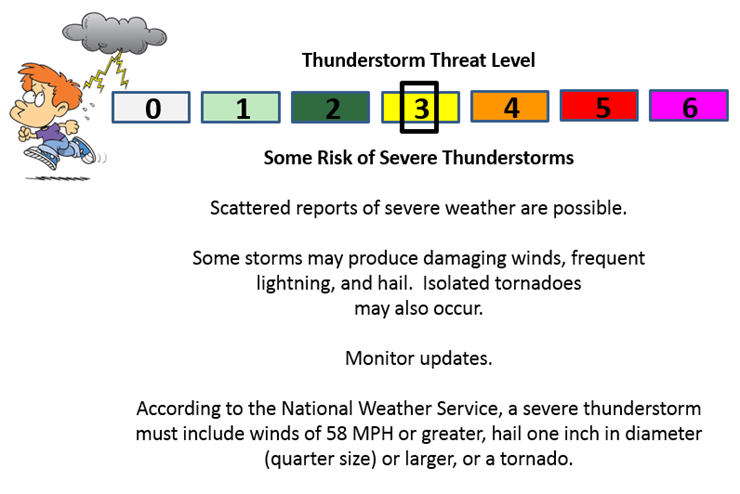
Can we expect severe thunderstorms over the next 24 to 48 hours? Remember that a severe thunderstorm is defined as a thunderstorm that produces 58 mph winds or higher, quarter size hail or larger, and/or a tornado.
Thunderstorm threat level is a ONE for Sunday night. A THREE for Monday and Monday night.
Sunday Night – Severe storms are not anticipated. Isolated strong storm possible.
Monday and Monday night – Severe storms are possible in and near our region. An outbreak of severe thunderstorms is forecast for parts of Illinois into Kentucky. Again, perhaps our northern and eastern counties. Much of our region will likely miss out on this event. But, as always monitor updates.

Hot temperatures. Heat index values above 100.
Severe weather potential on Monday and Monday night in and near our region. Monitor updates.

Here are the current river stage forecasts. You can click your state and then the dot for your location. It will bring up the full forecast and hydrograph.
Click Here For River Stage Forecasts…
Here are some current forecast hydrographs. These will be updated each day with new information.


Smithland Lock and Dam

Paducah, Kentucky Forecast Stage

Cairo, Illinois

Cape Girardeau, Missouri
Current Temperatures Around The Local Area


We have regional radars and local city radars – if a radar does not seem to be updating then try another one. Occasional browsers need their cache cleared. You may also try restarting your browser. That usually fixes the problem. Occasionally we do have a radar go down. That is why I have duplicates. Thus, if one fails then try another one.
If you have any problems then please send me an email beaudodson@usawx.com
WEATHER RADAR PAGE – Click here —
We also have a new national interactive radar – you can view that radar by clicking here.
Local interactive city radars include St Louis, Mt Vernon, Evansville, Poplar Bluff, Cape Girardeau, Marion, Paducah, Hopkinsville, Memphis, Nashville, Dyersburg, and all of eastern Kentucky – these are interactive radars. Local city radars – click here
NOTE: Occasionally you will see ground clutter on the radar (these are false echoes). Normally they show up close to the radar sites – including Paducah.

Regional Radar – Click on radar to take you our full radar page.


Regional Radar

Live Lightning Data – zoom and pan: Click here
Live Lightning Data with sound (click the sound button on the left side of the page): Click here
I also set up a storm tracking page with additional links (use during active weather for quick reference)
Storm Tracking Tool Page
![]()
Current WARNINGS (a warning means take action now). Click on your county to drill down to the latest warning information. Keep in mind that there can be a 2-3 minute delay in the updated warning information.
I strongly encourage you to use a NOAA Weather Radio or warning cell phone app for the most up to date warning information. Nothing is faster than a NOAA weather radio.


Color shaded counties are under some type of watch, warning, advisory, or special weather statement. Click your county to view the latest information.

Missouri Warnings

Illinois Warnings

Kentucky Warnings

Here is the official 6-10 day and 8-14 day temperature and precipitation outlook. Check the date stamp at the top of each image (so you understand the time frame).
The forecast maps below are issued by the Weather Prediction Center (NOAA).


The latest 8-14 day temperature and precipitation outlook. Note the dates are at the top of the image. These maps DO NOT tell you how high or low temperatures or precipitation will be. They simply give you the probability as to whether temperatures or precipitation will be above or below normal.


Who do you trust for your weather information and who holds them accountable?
I have studied weather in our region since the late 1970’s. I have 37 years of experience in observing our regions weather patterns. My degree is in Broadcast Meteorology from Mississippi State University and an Associate of Science (AS). I am currently working on my Bachelor’s Degree in Geoscience. Just need to finish two Spanish classes!
I am a member of the American Meteorological Society. I am a NOAA Weather-Ready Nation Ambassador. And, I am the Meteorologist for McCracken County Emergency Management.
I own and operate the Southern Illinois Weather Observatory.
There is a lot of noise on the internet. A lot of weather maps are posted without explanation. Over time you should learn who to trust for your weather information.
My forecast philosophy is simple and straight forward.
- Communicate in simple terms
- To be as accurate as possible within a reasonable time frame before an event
- Interact with you on Twitter, Facebook, and the blog
- Minimize the “hype” that you might see on television or through other weather sources
- Push you towards utilizing wall-to-wall LOCAL TV coverage during severe weather events
I am a recipient of the Mark Trail Award, WPSD Six Who Make A Difference Award, Kentucky Colonel, and the Caesar J. Fiamma” Award from the American Red Cross. In 2009 I was presented with the Kentucky Office of Highway Safety Award. I was recognized by the Kentucky House of Representatives for my service to the State of Kentucky leading up to several winter storms and severe weather outbreaks.
If you click on the image below you can read the Kentucky House of Representatives Resolution.

I am also President of the Shadow Angel Foundation which serves portions of western Kentucky and southern Illinois.
Many of my graphics are from www.weatherbell.com – a great resource for weather data, model data, and more


You can sign up for my AWARE email by clicking here I typically send out AWARE emails before severe weather, winter storms, or other active weather situations. I do not email watches or warnings. The emails are a basic “heads up” concerning incoming weather conditions.