
.
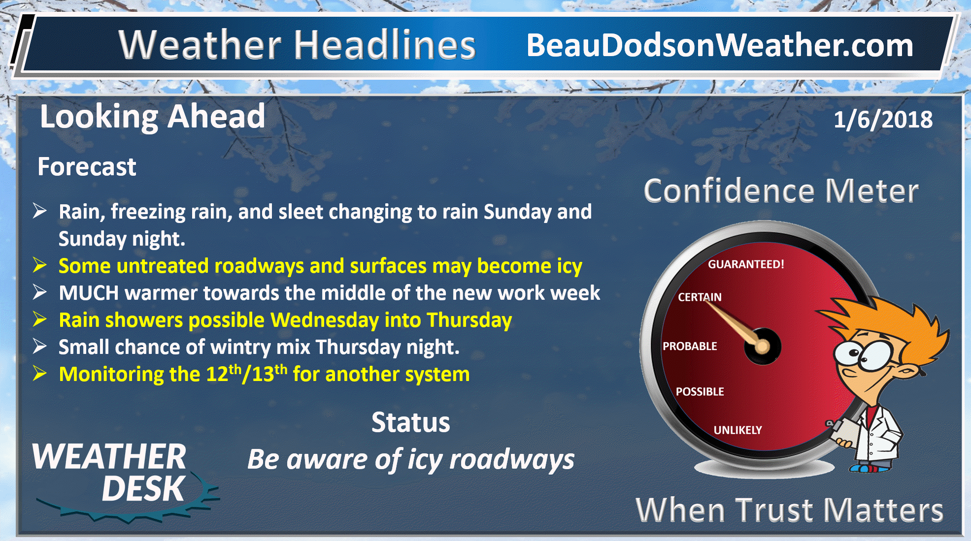
Updated Sunday at 12 PM
January 6, 2018
Saturday Night Forecast Details:
Forecast: Increasing clouds. Precipitation should hold off until Sunday. Increasing clouds overnight. A slight chance of freezing rain or sleet over southeast Missouri. Cold.
Temperatures: MO ~ 16 to 24 IL ~ 15 to 20 KY ~ 16 to 22
What is the chance of precipitation? MO ~ 20% (late) IL ~ 20% (late) KY ~ 10% TN ~ 10%
Coverage of precipitation: Most likely none. Small chance after 3 AM over southeast Missouri.
Wind chill values: 15 to 20
Accumulating snow or ice: Most likely none. The precip should hold off until Sunday.
Winds: Southeast at 5 to 10 mph
What impacts are anticipated from the weather? Icy roads if sleet or freezing rain develops. Low chance.
My confidence in the forecast verifying: High
Is severe weather expected? No
The NWS defines severe weather as 58 mph wind or great, 1″ hail or larger, and/or tornadoes
Should I cancel my outdoor plans: No
.
January 7, 2018
Sunday Forecast Details
Forecast: Cloudy. Rain developing. A period of freezing rain possible over our northern counties and perhaps far eastern counties. For the most part, this is a rain event.
Temperatures: MO ~ 33 to 42 IL ~ 34 to 42 KY ~ 36 to 44
What is the chance of precipitation? MO ~ 80% IL ~ 80% KY ~ 80% TN ~ 80%
Coverage of precipitation: Widespread
Wind chill values: 28 to 38
Accumulating snow or ice: A few icy spots are possible where surfaces remain cold.
Winds: South wind 7 to 14 mph with gusts to 25 mph
What impacts are anticipated from the weather? Wet roadways. Some icy roads are possible over our northern counties. Icy porches and sidewalks possible.
My confidence in the forecast verifying: High
Is severe weather expected? No
The NWS defines severe weather as 58 mph wind or great, 1″ hail or larger, and/or tornadoes
Should I cancel my outdoor plans? Have a plan B during the afternoon hours.
.
January 7, 2018
Sunday Night Forecast Details
Forecast: Cloudy. Breezy. Steady or slowly rising temperatures. Rain likely. Any freezing rain should change to rain. I will monitor our far eastern counties where it might be a few degrees colder.
Temperatures: MO ~ 34 to 44 IL ~ 34 to 44 KY ~ 34 to 44
What is the chance of precipitation? MO ~ 80% IL ~ 80% KY ~ 80% TN ~ 80%
Coverage of precipitation: Widespread
Wind chill values: 30 to 40
Accumulating snow or ice: Most of the precipitation should be rain.
Winds: South and southeast wind 10 to 20 mph with gusts to 30 mph
What impacts are anticipated from the weather? Wet roadways.
My confidence in the forecast verifying: Medium
Is severe weather expected? No
The NWS defines severe weather as 58 mph wind or great, 1″ hail or larger, and/or tornadoes
Should I cancel my outdoor plans? Have a plan B
.
January 8, 2018
Monday Forecast Details
Forecast: Cloudy. Some remaining showers. Showers ending.
Temperatures: MO ~ 40 to 45 IL ~ 40 to 45 KY ~ 40 to 45
What is the chance of precipitation? MO ~ 30% IL ~ 40% KY ~ 50% TN ~ 50%
Coverage of precipitation: Scattered
Wind chill values: 35 to 40
Accumulating snow or ice: No
Winds: North and northwest at 5 to 10 mph
What impacts are anticipated from the weather? Wet roadways..
My confidence in the forecast verifying: High
Is severe weather expected? No
The NWS defines severe weather as 58 mph wind or great, 1″ hail or larger, and/or tornadoes
Should I cancel my outdoor plans? Have a plan B during the morning hours
.
Monday Night Forecast Details:
Forecast: Cloudy. Chilly. Patchy fog and drizzle possible. I will monitor the potential of freezing drizzle.
Temperatures: MO ~ 26 to 34 IL ~ 25 to 32 KY ~ 30 to 35
What is the chance of precipitation? MO ~ 20% IL ~ 20% KY ~ 20% TN ~ 20%
Coverage of precipitation: Isolated
Wind chill values: 15 to 25
Accumulating snow or ice: Monitor updates on drizzle
Winds: Variable wind at 5 to 10 mph
What impacts are anticipated from the weather? Fog may reduce visibility. I will monitor the freezing drizzle potential.
My confidence in the forecast verifying: High
Is severe weather expected? No
The NWS defines severe weather as 58 mph wind or great, 1″ hail or larger, and/or tornadoes
Should I cancel my outdoor plans: No
.
January 9, 2018
Tuesday Forecast Details
Forecast: A mix of sun and clouds. Isolated shower possible.
Temperatures: MO ~ 42 to 46 IL ~ 42 to 46 KY ~ 45 to 50
What is the chance of precipitation? MO ~ 10% IL ~ 10% KY ~ 10% TN ~ 10%
Coverage of precipitation: Isolated
Wind chill values: N/A
Accumulating snow or ice: No
Winds: East wind 5 to 10 mph
What impacts are anticipated from the weather? None to isolated wet roadways.
My confidence in the forecast verifying: High
Is severe weather expected? No
The NWS defines severe weather as 58 mph wind or great, 1″ hail or larger, and/or tornadoes
Should I cancel my outdoor plans? No
.
Tuesday Night Forecast Details:
Forecast: Partly to mostly cloudy. Isolated showers possible.
Temperatures: MO ~ 38 to 44 IL ~ 36 to 42 KY ~ 38 to 44
What is the chance of precipitation? MO ~ 20% IL ~ 20% KY ~ 20% TN ~ 20%
Coverage of precipitation: None to isolated
Wind chill values: 30 to 40
Accumulating snow or ice: No
Winds: Southeast wind at 5 to 10 mph
What impacts are anticipated from the weather? Perhaps wet roadways
My confidence in the forecast verifying: Medium
Is severe weather expected? No
The NWS defines severe weather as 58 mph wind or great, 1″ hail or larger, and/or tornadoes
Should I cancel my outdoor plans: No
.
January 10, 2018
Wednesday Forecast Details
Forecast: Mostly cloudy. Isolated showers possible.
Temperatures: MO ~ 55 to 60 IL ~ 55 to 60 KY ~ 55 to 60
What is the chance of precipitation? MO ~ 30% IL ~ 20% KY ~ 20% TN ~ 20%
Coverage of precipitation: Isolated
Wind chill values: N/A
Accumulating snow or ice: No
Winds: Variable wind 5 to 10 mph
What impacts are anticipated from the weather? A few wet roadways possible
My confidence in the forecast verifying: Medium
Is severe weather expected? No
The NWS defines severe weather as 58 mph wind or great, 1″ hail or larger, and/or tornadoes
Should I cancel my outdoor plans? No
.
Wednesday Night Forecast Details:
Forecast: Increasing clouds. Showers possible.
Temperatures: MO ~ 48 to 54 IL ~ 48 to 54 KY ~ 48 to 54
What is the chance of precipitation? MO ~ 40% IL ~ 40% KY ~ 40% TN ~ 40%
Coverage of precipitation: Scattered
Wind chill values: N/A
Accumulating snow or ice: No
Winds: South winds at 8 to 16 mph
What impacts are anticipated from the weather? Wet roadways
My confidence in the forecast verifying: Medium
Is severe weather expected? No
The NWS defines severe weather as 58 mph wind or great, 1″ hail or larger, and/or tornadoes
Should I cancel my outdoor plans: No
.
January 11, 2018
Thursday Forecast Details
Forecast: Mostly cloudy. Rain showers likely. Milder. Windy.
Temperatures: MO ~ 55 to 60 IL ~ 55 to 60 KY ~ 55 to 60
What is the chance of precipitation? MO ~ 50% IL ~ 50% KY ~ 50% TN ~ 50%
Coverage of precipitation: Scattered
Wind chill values: N/A
Accumulating snow or ice: No
Winds: South at 10 to 20 mph
What impacts are anticipated from the weather? Wet roadways
My confidence in the forecast verifying: Medium
Is severe weather expected? No
The NWS defines severe weather as 58 mph wind or great, 1″ hail or larger, and/or tornadoes
Should I cancel my outdoor plans? Have a plan B
.
Thursday Night Forecast Details:
Forecast: Cloudy. Rain. Rain may change to a wintry mix. Low confidence on that subject. Turning colder.
Temperatures: MO ~ 28 to 34 IL ~ 28 to 34 KY ~ 30 to 34
What is the chance of precipitation? MO ~ 60% IL ~ 60% KY ~ 60% TN ~ 60%
Coverage of precipitation: Perhaps widespread
Wind chill values: 25 to 35
Accumulating snow or ice: Monitor updates
Winds: Becoming west and northwest at 8 to 16 mph and gusty
What impacts are anticipated from the weather? Wet roadways. Monitor updates concerning wintry mix potential. Low confidence.
My confidence in the forecast verifying: LOW
Is severe weather expected? No
The NWS defines severe weather as 58 mph wind or great, 1″ hail or larger, and/or tornadoes
Should I cancel my outdoor plans: Have a plan B
.

.
Sunday afternoon through Monday: A brief window of opportunity for freezing rain over portions of the area. For the most part, this is a rain event.
Northern portions of southeast Missouri, northern portions of southern Illinois, the Kentucky/Indiana border counties, and perhaps our far eastern counties might have to deal with patchy freezing rain changing to plain rain. Use care on surfaces that are cold. There might be some ice.
January 12th and 13th: Monitor updates. Another precipitation event is possible.
.

.
The National Weather Service definition of a severe thunderstorm is one that produces quarter size hail or larger, 58 mph winds or greater, and/or a tornado.
Now through next Friday: Severe storms are not anticipated.
.

Interactive Weather Radar Page. Choose the city nearest your location: Click this link
Forecast
Interactive Weather Radar Page. Choose the city nearest your location: Click this link
The main topic of discussion will be Sunday’s precipitation event.
A widespread rain event will push into the region Sunday afternoon and night. Some of the rain might be freezing rain (for portions of the region).
Here is my rainfall totals forecast. This is the probability of X amount of rain falling.
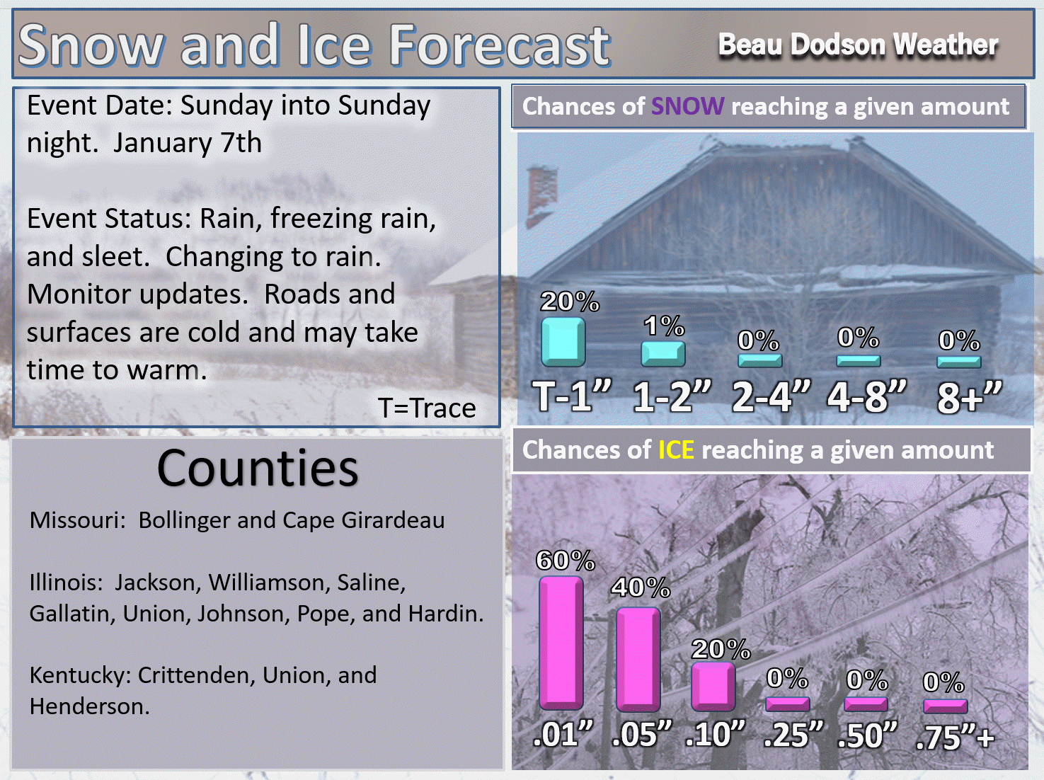
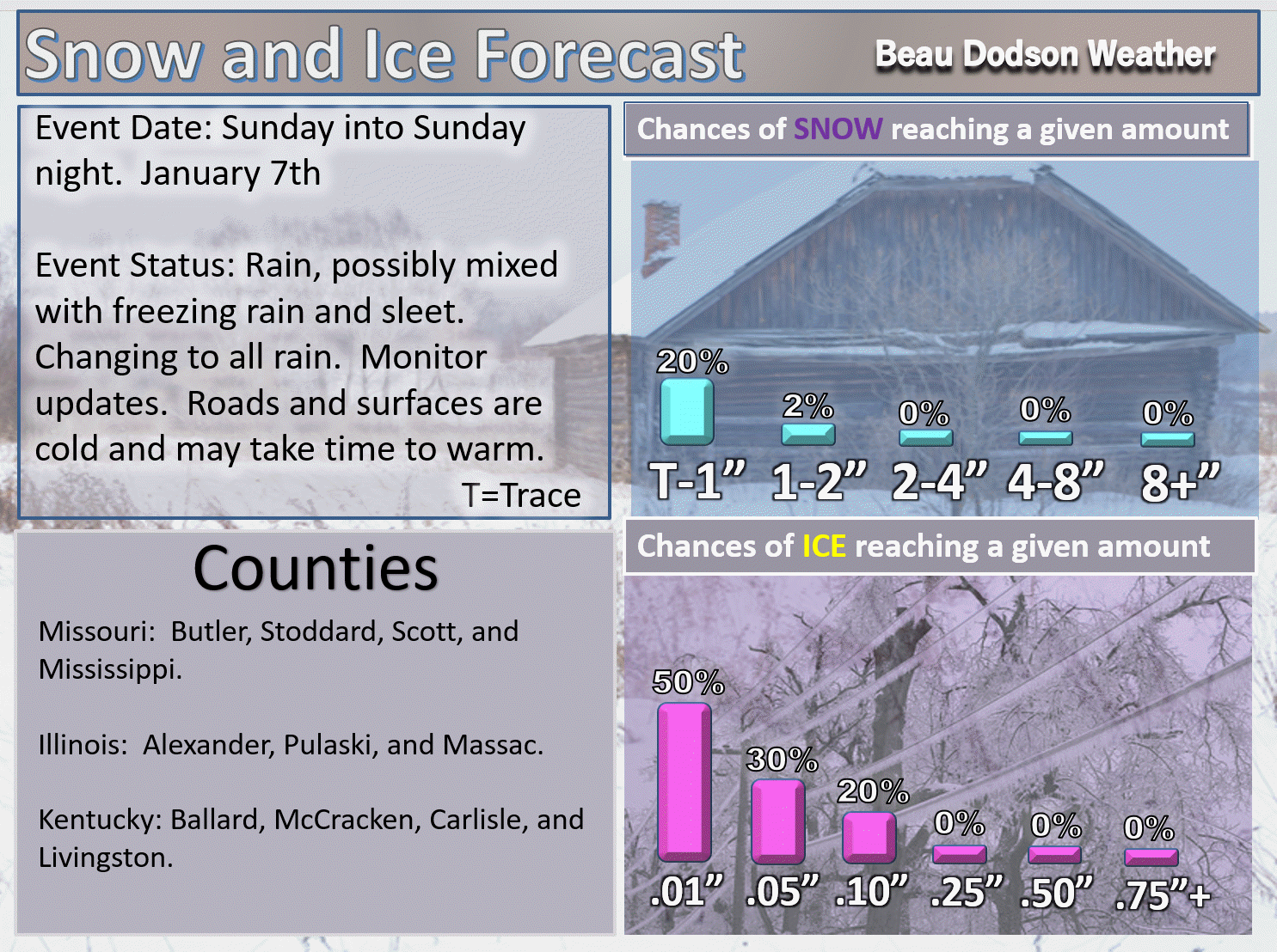
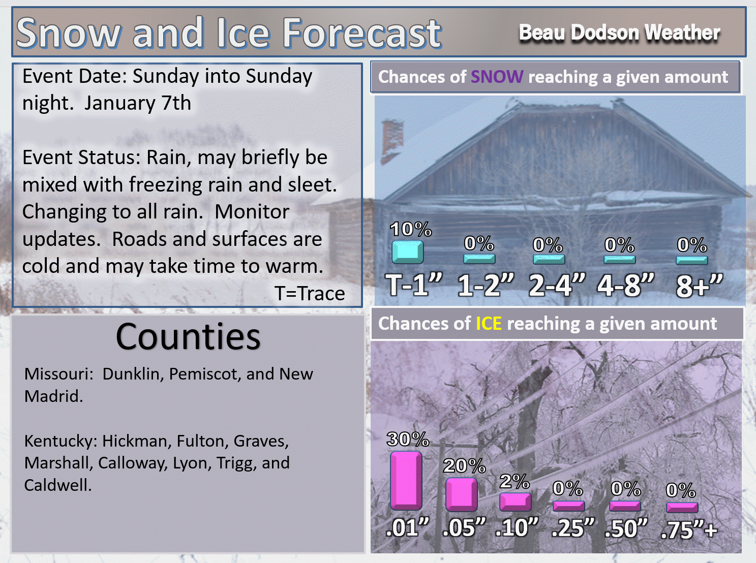
Southeast MO and southern IL
.

.
And below is the west Kentucky and northwest Tennessee map
.

.
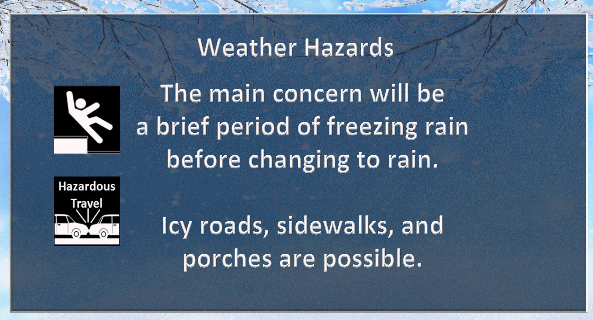
Rain, freezing rain, and some sleet will be possible at the onset of precipitation. Everything should change to rain as we move later into Sunday afternoon and night.
We will need to monitor the Missouri Ozarks, our far northern and eastern counties. Temperatures may remain colder there for a longer period of time.
Here are my latest probability maps.
KEEP IN MIND, the issue is not so much amounts as it is impacts. It will only take a hint of freezing rain to cause untreated roadways to become icy. Thus, the main concern is not how much freezing rain falls, but rather to end result of that freezing rain. Meaning: Icy roads. Icy sidewalks. Icy porches.
The further south you travel in the region, the lesser the concern will be.
Frozen precipitation will change to all rain area-wide Sunday afternoon and night. Our far eastern counties will need to be monitored a bit more closely Sunday night (over towards Webster County, KY towards Christian County)
.
.
.
.
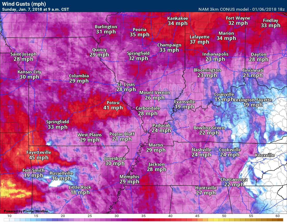
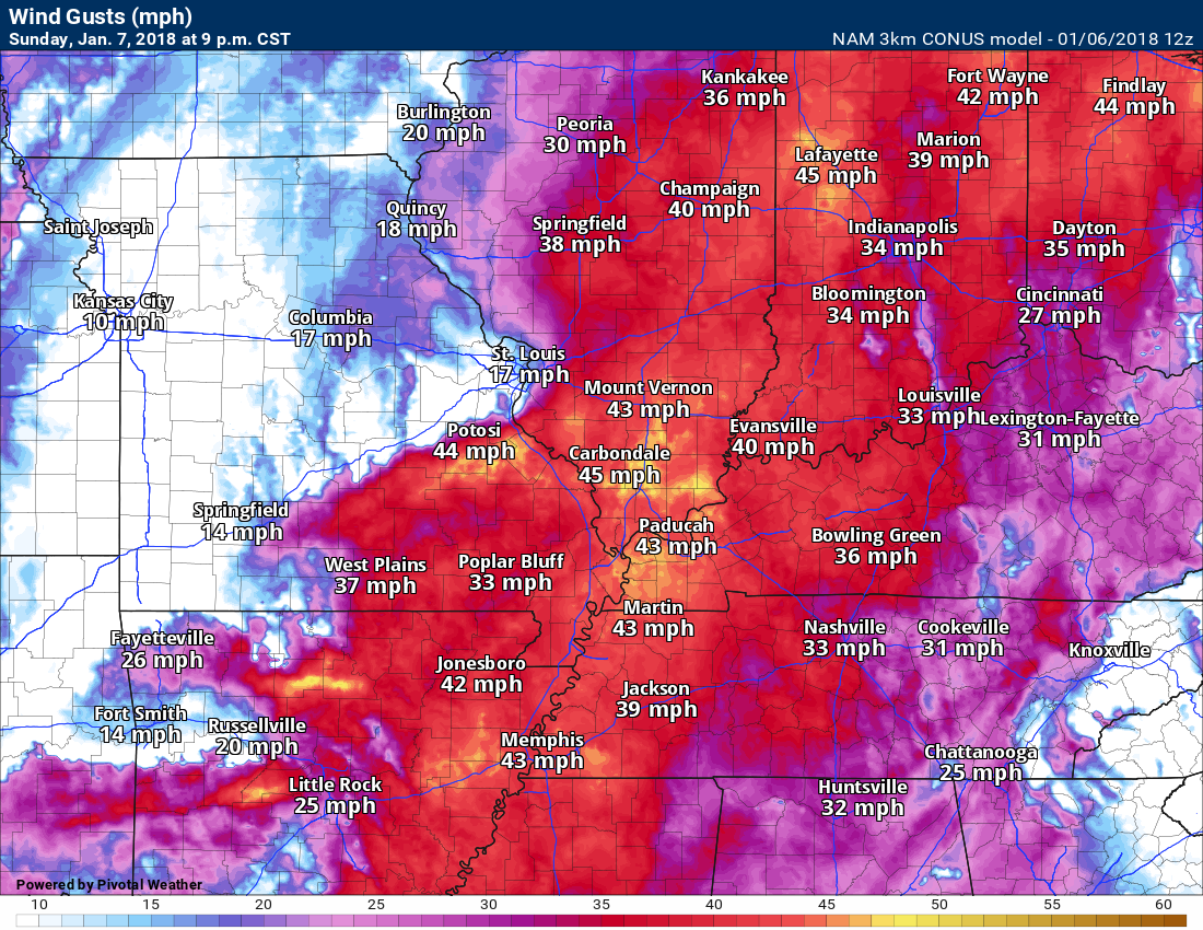
We may have some gusty winds Sunday and Sunday night. Here is the NAM guidance winds. It might be a bit too high, but you get the general idea.
Sunday 9 AM
.
Sunday night
.
.
County by county probabilities
.

2
3
4
5

.
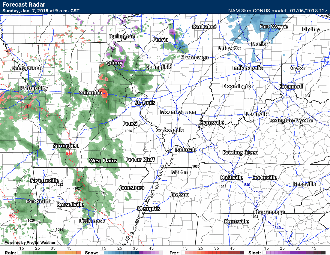
Widespread precipitation will develop across northern Arkansas and Missouri late Saturday night into Sunday. This precipitation will spread eastward during the late morning hours into the afternoon hours.
Here is the NAM future-cast radar.
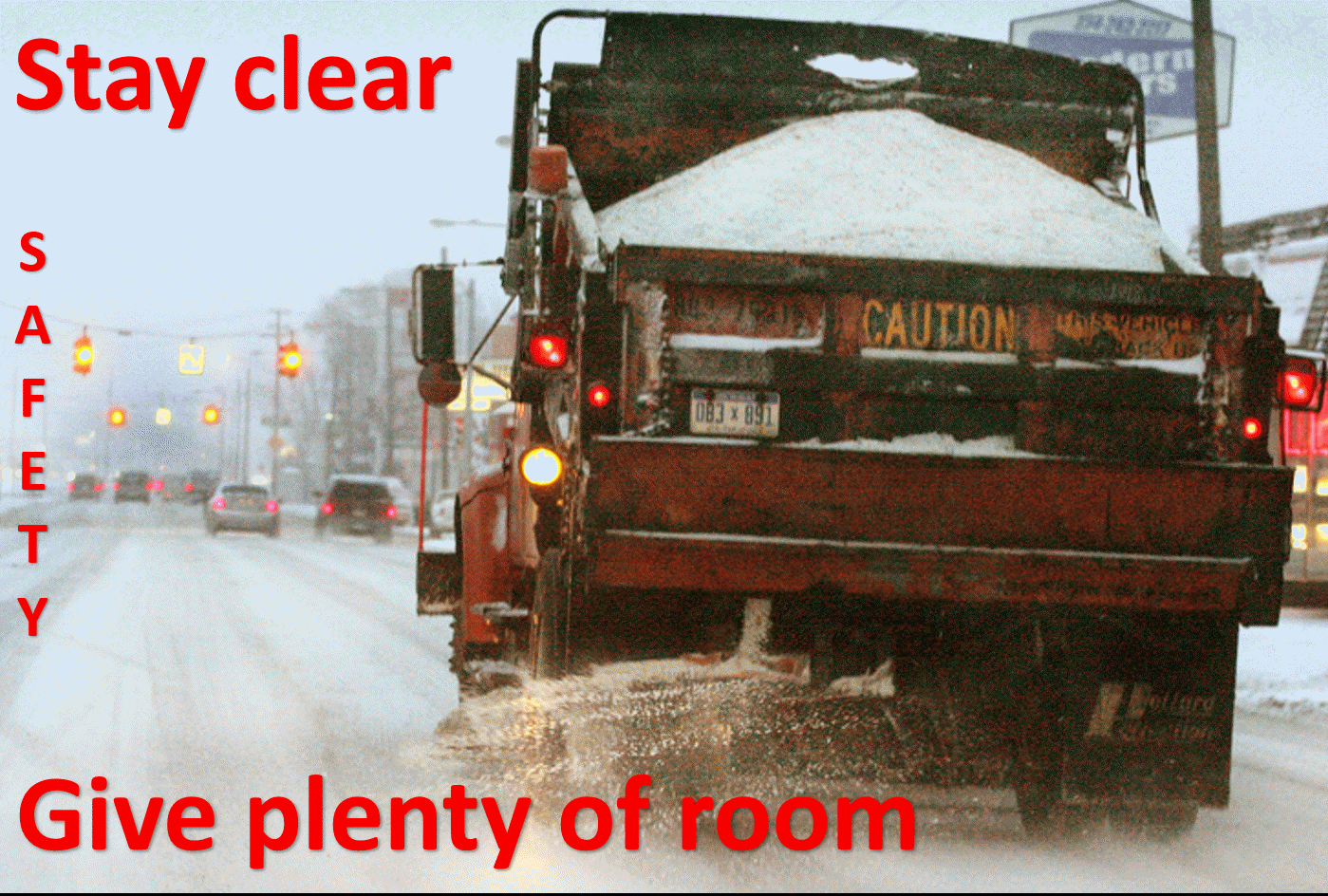
You need to keep in mind that ground and road temperatures are very cold. Even if the surface temperatures are above 32 degrees, we could have icy roads develop. It will take time for road temperatures to rise. That goes the same for sidewalks and porches. Use care. What may look wet could be ice.
Don’t focus on exactly where the NAM is showing rain vs snow/ice. We may have at least a short period of freezing rain and sleet. The northern half of the area is where that will linger longer. I am also monitoring our far eastern counties. It may be colder there for a period of time Sunday afternoon and night.
Green is rain. Blue is snow. Pink/Red is a wintry mix of sleet and freezing rain. Again, this won’t be exact.
.
.
The NAM guidance shows you where it expects freezing rain. Areas not included could also see a period of freezing, but not as much as other areas.
This is the NAM guidance and it is that models opinion. It won’t be exact.
The Missouri Ozarks is one area of concern. Again, just because there isn’t red or pink in your county does not mean there won’t be some icing. Roads and surfaces are very cold. Models don’t handle cold air all that well.
Notice to our east. There is a second area of concern over our far eastern counties. That will need to be monitored. Temperatures may remain colder there. If you have travel plans from or to central Kentucky, then monitor advisories.
.

.
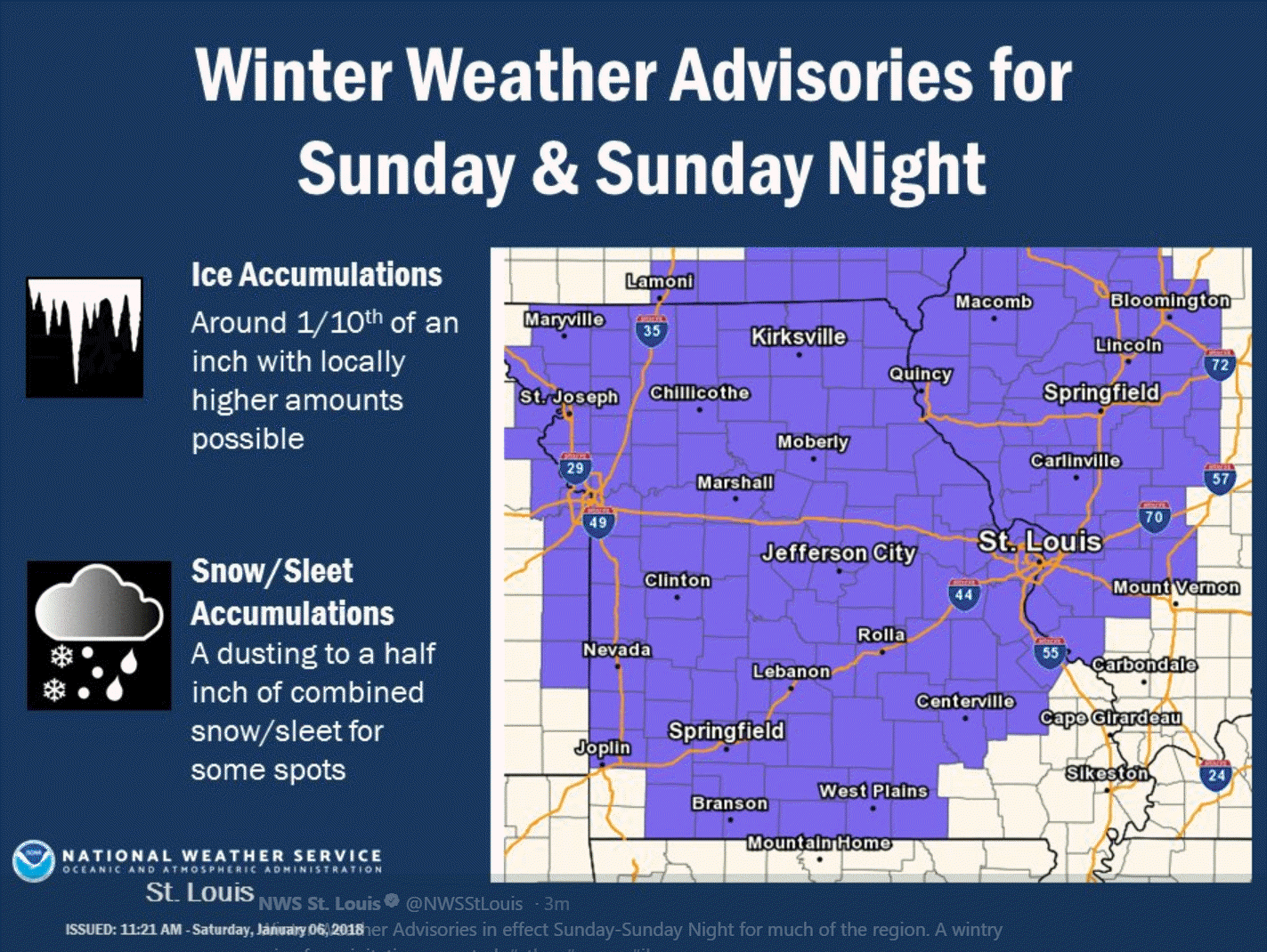
Freezing rain winter weather advisories will be issued for some of our local counties. The main concern will be non-treated roadways becoming icy. This is esp true for southeast Missouri and southern Illinois into northwest Kentucky. A second area of concern will be our far eastern counties from Webster County, KY down towards Christian County, Kentucky. There is a chance the colder temps may linger longer in those areas.
The St Louis, Missouri NWS Office has already issued a winter weather advisory for some of their counties. Additional counties may need to be added to this map.
This map was posted at 11 AM. Make sure you see the latest NWS watches, warnings, and advisories.
.
.
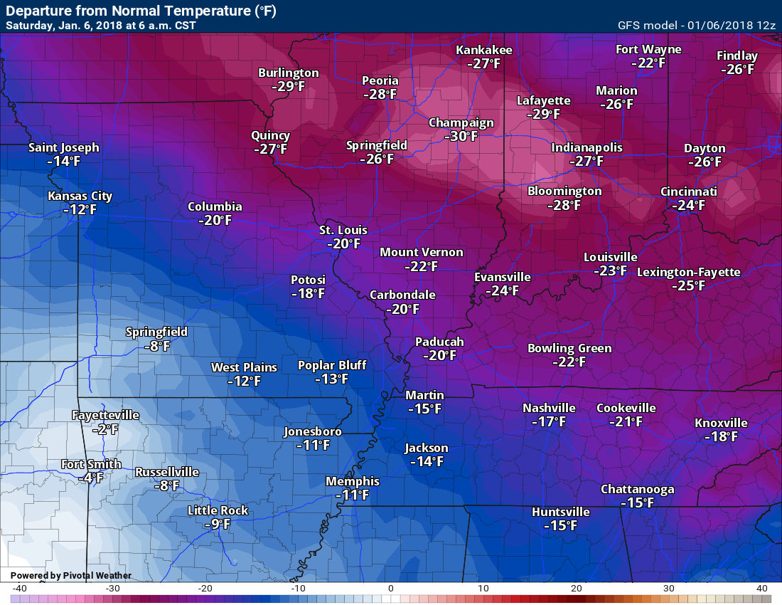
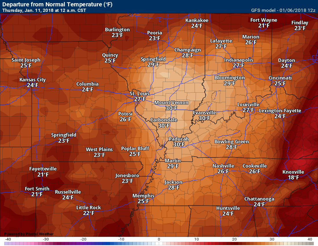
Check out the temperature anomaly map for today compared to this coming Thursday. What a change!
These maps show you how many degrees above or below normal temperatures will be.
Today
.
.
Thursday
.
I am monitoring the 12th and 13th for another system. Some of the guidance is indicating frozen precipitation.


We offer regional radars and local city radars – if a radar does not update then try another one. Occasional browsers need their cache cleared. You may also try restarting your browser. This will usually fix any problems.
During the winter you can track snow and ice by clicking the winterize button on the local city view interactive radars.
You may email me at beaudodson@usawx.com
Interactive Weather Radar Page. Choose the city nearest your location: Click this link
National interactive radar: Click this link.