
.
January 5, 2018
Friday Night Forecast Details:
Forecast: A few clouds. Clearing. Cold.
Temperatures: MO ~ 6 to 12 IL ~ -2 to 6 above KY ~ 6 to 12
What is the chance of precipitation? MO ~ 0% IL ~ 0% KY ~ 0% TN ~ 0%
Coverage of precipitation: Most likely none
Wind chill values: -5 to 10
Accumulating snow or ice: No
Winds: North and northeast winds 6 to 12 mph
What impacts are anticipated from the weather? Cold wind chills
My confidence in the forecast verifying: High
Is severe weather expected? No
The NWS defines severe weather as 58 mph wind or great, 1″ hail or larger, and/or tornadoes
Should I cancel my outdoor plans: It will be quite cold
.
January 6, 2018
Saturday Forecast Details
Forecast: Mostly sunny.
Temperatures: MO ~ 26 to 32 IL ~ 25 to 30 KY ~ 25 to 30
What is the chance of precipitation? MO ~ 0% IL ~ 0% KY ~ 0% TN ~ 0%
Coverage of precipitation: None
Wind chill values: 20 to 30
Accumulating snow or ice: No
Winds: East 4 to 8 mph
What impacts are anticipated from the weather? None
My confidence in the forecast verifying: High
Is severe weather expected? No
The NWS defines severe weather as 58 mph wind or great, 1″ hail or larger, and/or tornadoes
Should I cancel my outdoor plans? No
.
Saturday Night Forecast Details:
Forecast: Increasing clouds. Precipitation should hold off until Sunday. Increasing clouds overnight. A slight chance of freezing rain or sleet over southeast Missouri.
Temperatures: MO ~ 16 to 24 IL ~ 15 to 20 KY ~ 16 to 22
What is the chance of precipitation? MO ~ 20% (late) IL ~ 20% (late) KY ~ 10% TN ~ 10%
Coverage of precipitation: Most likely none. Small chance after 3 AM over southeast Missouri.
Wind chill values: 15 to 20
Accumulating snow or ice: Most likely none. The precip should hold off until Sunday.
Winds: Southeast at 5 to 10 mph
What impacts are anticipated from the weather? Icy roads if sleet or freezing rain develops. Low chance.
My confidence in the forecast verifying: High
Is severe weather expected? No
The NWS defines severe weather as 58 mph wind or great, 1″ hail or larger, and/or tornadoes
Should I cancel my outdoor plans: No
.
January 7, 2018
Sunday Forecast Details
Winter weather advisory for portions of the region.
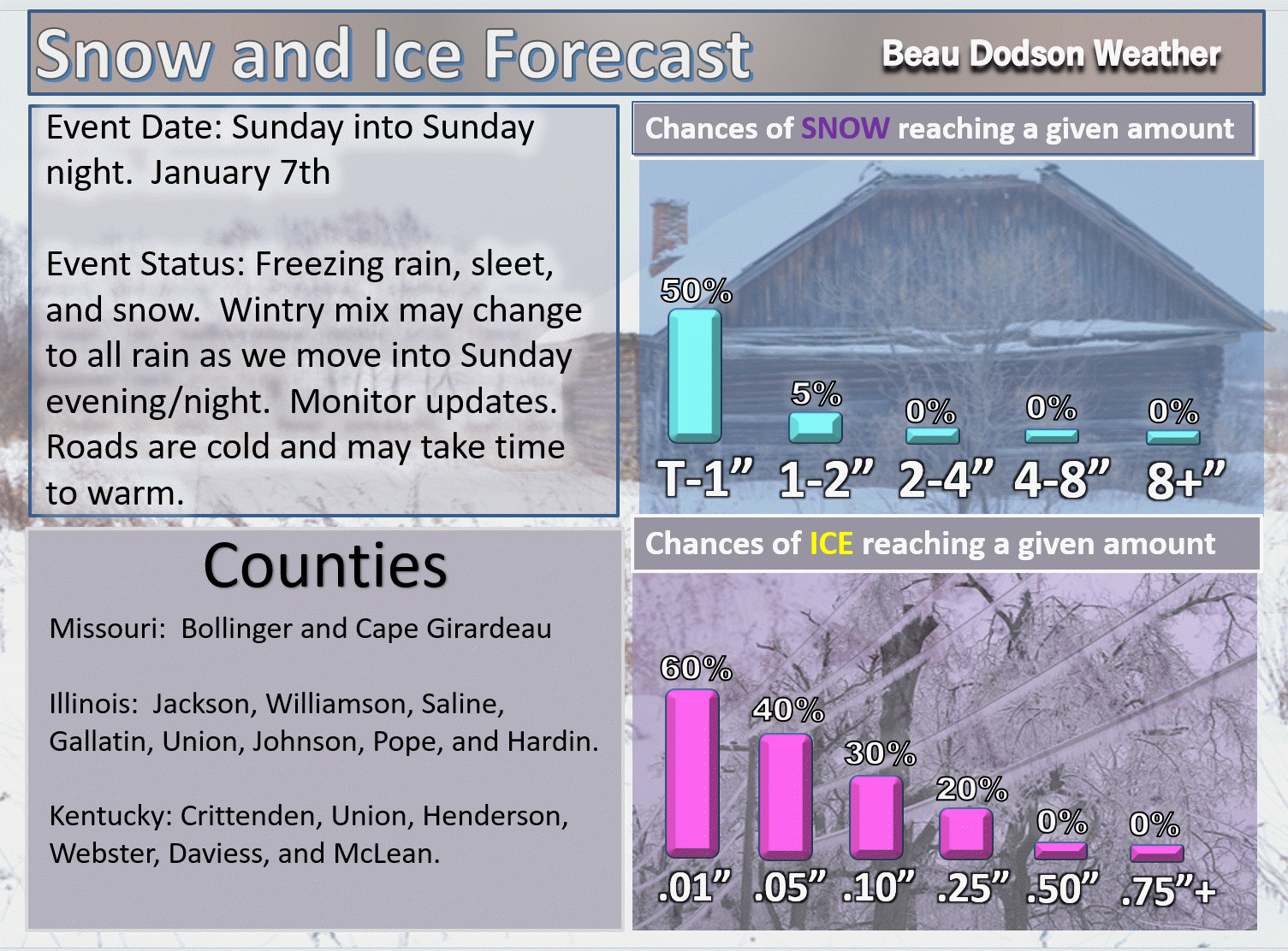
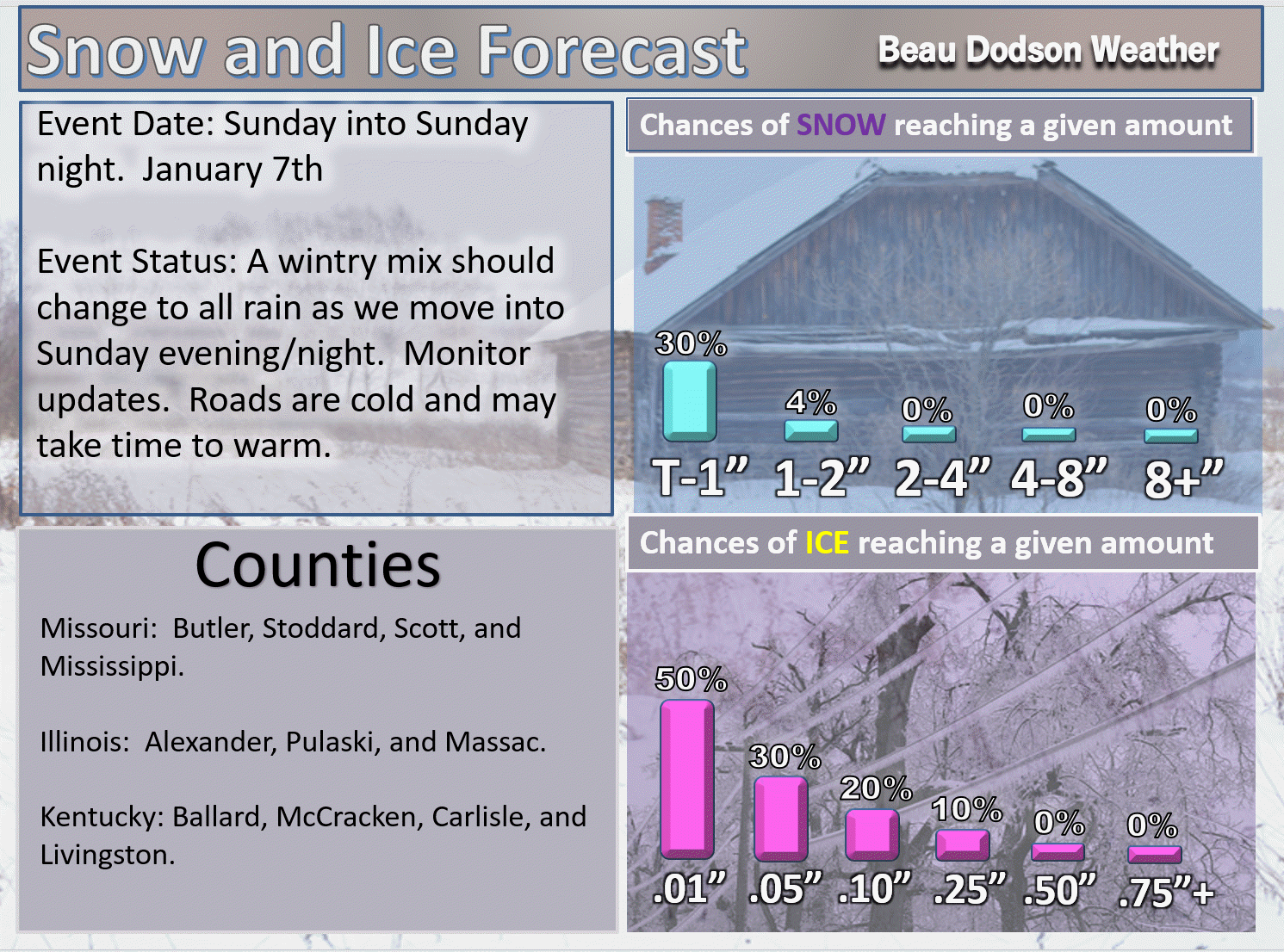
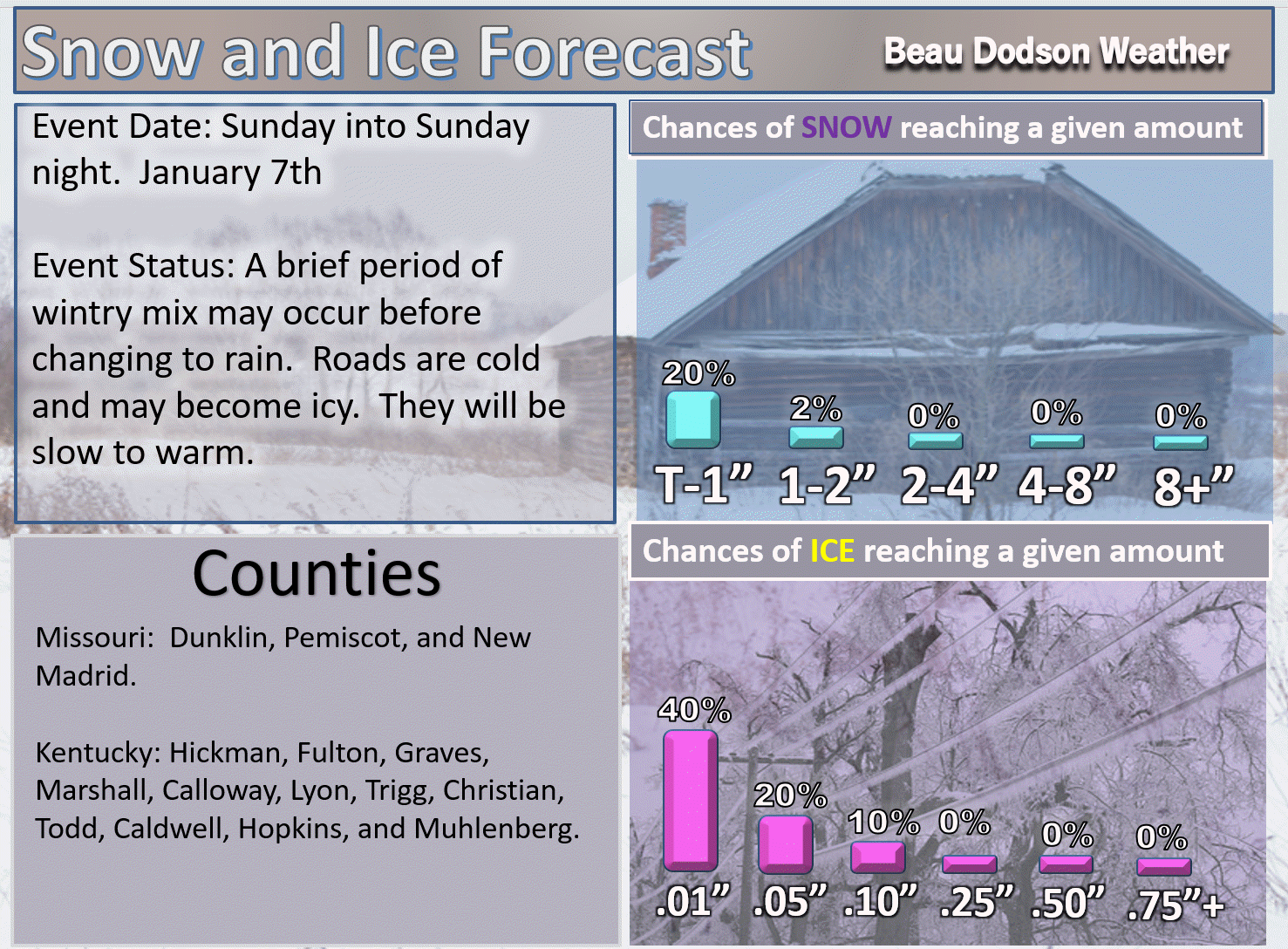
Forecast: Cloudy. Patchy rain, freezing rain, sleet, and snow developing mainly during the afternoon hours. Precipitation will move into the region from the west. Patchy precipitation may arrive before the main band of precipitation. Keep that in mind. The main band should arrive in southeast Missouri between 10 am and 2 pm. It should arrive in southern Illinois between 12 pm and 3 pm. It should arrive in western Kentucky between 12 pm and 4 pm. It should arrive in northwest Tennessee between 12 pm and 4 pm. That means the Pennyrile area of western Kentucky will be last in receiving precipitation. Precipitation may change to all rain from south to north as temperatures will be on the rise. Remember, surfaces are cold. Rain may freeze on surfaces even after temps rise above the freezing mark. A period of icy roads will be possible (non-treated roads). Sidewalks and porches may also have ice on them. See the county breakdown maps further down in this blog update.
Temperatures: MO ~ 31 to 38 IL ~ 32 to 36 KY ~ 34 to 38
What is the chance of precipitation? MO ~ 30% before noon and then 70% afternoon IL ~ 30% before noon and then 70% afternoon KY ~ 20% before 11 am and then increasing to 60% TN ~ 20% before noon and then increasing to 60%
Coverage of precipitation: Scattered with increasing coverage through the afternoon hours.
Wind chill values: 25 to 35
Accumulating snow or ice: Some light ice accumulation is possible. It would only take a little bit to cause icy roads, bridges, sidewalks, and porches.
Winds: South wind 5 to 10 mph with gusts to 20 mph
What impacts are anticipated from the weather? Icy roads are possible. Icy porches and sidewalks possible.
My confidence in the forecast verifying: High
Is severe weather expected? No
The NWS defines severe weather as 58 mph wind or great, 1″ hail or larger, and/or tornadoes
Should I cancel my outdoor plans? Have a plan B during the afternoon hours.
.
January 7, 2018
Sunday Night Forecast Details
Forecast: Cloudy. Rain likely. Rain may be mixed with freezing rain over northern portions of southeast MO and northern portions of southern IL. Elsewhere, any wintry mix should change to rain. I will be monitoring our eastern counties. That would include Webster County, KY southward to Christian County, KY. There is a chance temperatures may remain lower in those areas. Monitor updates.
Temperatures: MO ~ 32 to 36 IL ~ 32 to 36 KY ~ 32 to 36
What is the chance of precipitation? MO ~ 70% IL ~ 70% KY ~ 70% TN ~ 70%
Coverage of precipitation: Widespread
Wind chill values: 25 to 35
Accumulating snow or ice: Monitor updates.
Winds: South wind 5 to 10 mph with gusts to 15 mph
What impacts are anticipated from the weather? Icy roads can’t be ruled out.
My confidence in the forecast verifying: Medium
Is severe weather expected? No
The NWS defines severe weather as 58 mph wind or great, 1″ hail or larger, and/or tornadoes
Should I cancel my outdoor plans? Have a plan B
.
January 8, 2018
Monday Forecast Details
Forecast: Cloudy. Rain showers likely. Chilly. I will be monitoring our far eastern counties from Webster down to Christian County. There is a risk that freezing rain could linger in that area and then east of there in central Kentucky.
Temperatures: MO ~ 38 to 42 IL ~ 36 to 42 KY ~ 38 to 44
What is the chance of precipitation? MO ~ 60% IL ~ 70% KY ~ 70% TN ~ 70%
Coverage of precipitation: Widespread.
Wind chill values: 30 to 40
Accumulating snow or ice: Most likely no. Monitor updates.
Winds: Southwest and west wind 5 to 10 mph
What impacts are anticipated from the weather? Wet roadways..
My confidence in the forecast verifying: Medium
Is severe weather expected? No
The NWS defines severe weather as 58 mph wind or great, 1″ hail or larger, and/or tornadoes
Should I cancel my outdoor plans? Have a plan B during the morning hours
.
Monday Night Forecast Details:
Forecast: Cloudy. Chilly. Patchy fog and drizzle possible. I will monitor the potential of freezing drizzle.
Temperatures: MO ~ 26 to 32 IL ~ 26 to 32 KY ~ 28 to 34
What is the chance of precipitation? MO ~ 20% IL ~ 20% KY ~ 20% TN ~ 20%
Coverage of precipitation: Spotty
Wind chill values: 15 to 25
Accumulating snow or ice: Most likely no
Winds: North wind at 5 to 10 mph
What impacts are anticipated from the weather? Fog may reduce visibility. I will monitor the freezing drizzle potential.
My confidence in the forecast verifying: High
Is severe weather expected? No
The NWS defines severe weather as 58 mph wind or great, 1″ hail or larger, and/or tornadoes
Should I cancel my outdoor plans: No
.
January 9, 2018
Tuesday Forecast Details
Forecast: A mix of sun and clouds. Cool.
Temperatures: MO ~ 45 to 50 IL ~ 45 to 50 KY ~ 45 to 50
What is the chance of precipitation? MO ~ 0% IL ~ 0% KY ~ 0% TN ~ 0%
Coverage of precipitation: None
Wind chill values: 30 to 40
Accumulating snow or ice: No
Winds: North wind 5 to 10 mph
What impacts are anticipated from the weather? None
My confidence in the forecast verifying: High
Is severe weather expected? No
The NWS defines severe weather as 58 mph wind or great, 1″ hail or larger, and/or tornadoes
Should I cancel my outdoor plans? No
.
Tuesday Night Forecast Details:
Forecast: Partly to mostly cloudy. Isolated showers possible.
Temperatures: MO ~ 38 to 44 IL ~ 36 to 42 KY ~ 38 to 44
What is the chance of precipitation? MO ~ 20% IL ~ 20% KY ~ 20% TN ~ 20%
Coverage of precipitation: None to isolated
Wind chill values: 35 to 40
Accumulating snow or ice: No
Winds: North wind at 5 to 10 mph
What impacts are anticipated from the weather? Perhaps wet roadways
My confidence in the forecast verifying: Medium
Is severe weather expected? No
The NWS defines severe weather as 58 mph wind or great, 1″ hail or larger, and/or tornadoes
Should I cancel my outdoor plans: No
.
January 10, 2018
Wednesday Forecast Details
Forecast: Some increase in clouds. Isolated showers possible, mainly early.
Temperatures: MO ~ 54 to 58 IL ~ 54 to 58 KY ~ 54 to 58
What is the chance of precipitation? MO ~ 20% IL ~ 20% KY ~ 20% TN ~ 20%
Coverage of precipitation: Isolated
Wind chill values: N/A
Accumulating snow or ice: No
Winds: Variable wind 5 to 10 mph
What impacts are anticipated from the weather? A few wet roadways possible
My confidence in the forecast verifying: Medium
Is severe weather expected? No
The NWS defines severe weather as 58 mph wind or great, 1″ hail or larger, and/or tornadoes
Should I cancel my outdoor plans? No
.
Wednesday Night Forecast Details:
Forecast: Increasing clouds. A chance of late night showers.
Temperatures: MO ~ 46 to 52 IL ~ 46 to 54 KY ~ 48 to 54
What is the chance of precipitation? MO ~ 30% IL ~ 30% KY ~ 30% TN ~ 30%
Coverage of precipitation: Scattered
Wind chill values: N/A
Accumulating snow or ice: No
Winds: South winds at 8 to 16 mph
What impacts are anticipated from the weather? Wet roadways
My confidence in the forecast verifying: Medium
Is severe weather expected? No
The NWS defines severe weather as 58 mph wind or great, 1″ hail or larger, and/or tornadoes
Should I cancel my outdoor plans: No
.
January 11, 2018
Thursday Forecast Details
Forecast: Mostly cloudy. Rain showers likely. Milder.
Temperatures: MO ~ 55 to 60 IL ~ 55 to 60 KY ~ 55 to 60
What is the chance of precipitation? MO ~ 50% IL ~ 50% KY ~ 50% TN ~ 50%
Coverage of precipitation: Scattered
Wind chill values: N/A
Accumulating snow or ice: No
Winds: South at 10 to 20 mph
What impacts are anticipated from the weather? Wet roadways
My confidence in the forecast verifying: Medium
Is severe weather expected? No
The NWS defines severe weather as 58 mph wind or great, 1″ hail or larger, and/or tornadoes
Should I cancel my outdoor plans? Have a plan B
.
Thursday Night Forecast Details:
Forecast: Cloudy. Rain showers possible. Rain may end as a brief period of wintry mix. Low confidence on that subject. Turning colder.
Temperatures: MO ~ 30 to 34 IL ~ 30 to 34 KY ~ 30 to 34
What is the chance of precipitation? MO ~ 60% IL ~ 60% KY ~ 60% TN ~ 60%
Coverage of precipitation: Scattered to perhaps widespread
Wind chill values: 25 to 35
Accumulating snow or ice: Monitor updates
Winds: Becoming west and northwest at 6 to 12 mph
What impacts are anticipated from the weather? Wet roadways. Monitor updates concerning wintry mix potential. Low confidence.
My confidence in the forecast verifying: LOW
Is severe weather expected? No
The NWS defines severe weather as 58 mph wind or great, 1″ hail or larger, and/or tornadoes
Should I cancel my outdoor plans: Have a plan B
.

.
Now through Saturday: Any remaining snow flurries or snow showers will come to an end this morning.
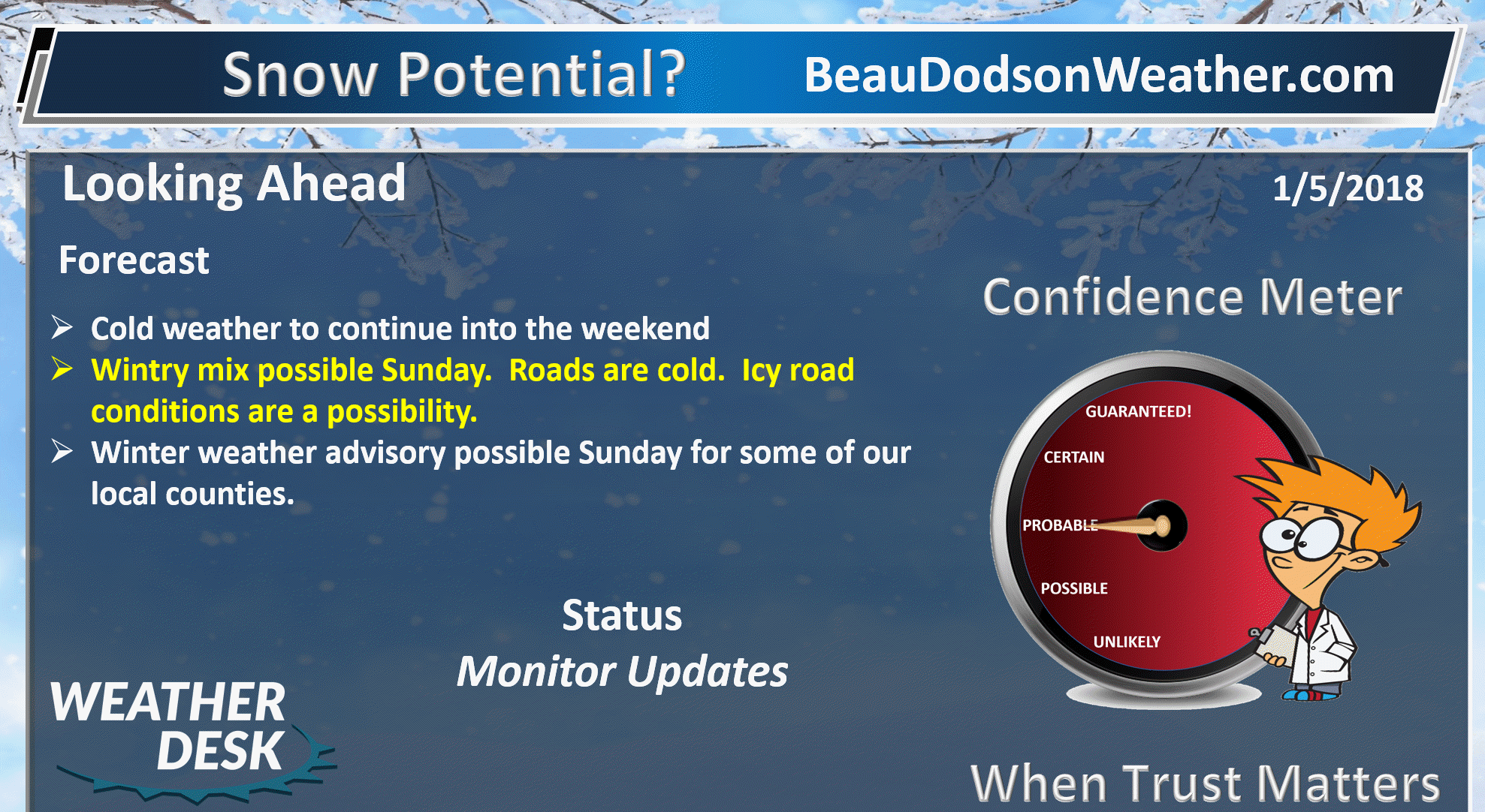
Saturday night through Monday: I continue to monitor the chance of a wintry mix on Sunday and Sunday night. There remain questions about temperatures. Temperatures are forecast to rise above freezing on Sunday. The question is when. Freezing rain, sleet, and snow will be possible across the area.
It only takes a small amount of freezing rain to cause icy roads. Roads are very cold.
.

.
The National Weather Service definition of a severe thunderstorm is one that produces quarter size hail or larger, 58 mph winds or greater, and/or a tornado.
Now through next Thursday: Severe storms are not anticipated.
.

Interactive Weather Radar Page. Choose the city nearest your location: Click this link
Forecast
Interactive Weather Radar Page. Choose the city nearest your location: Click this link
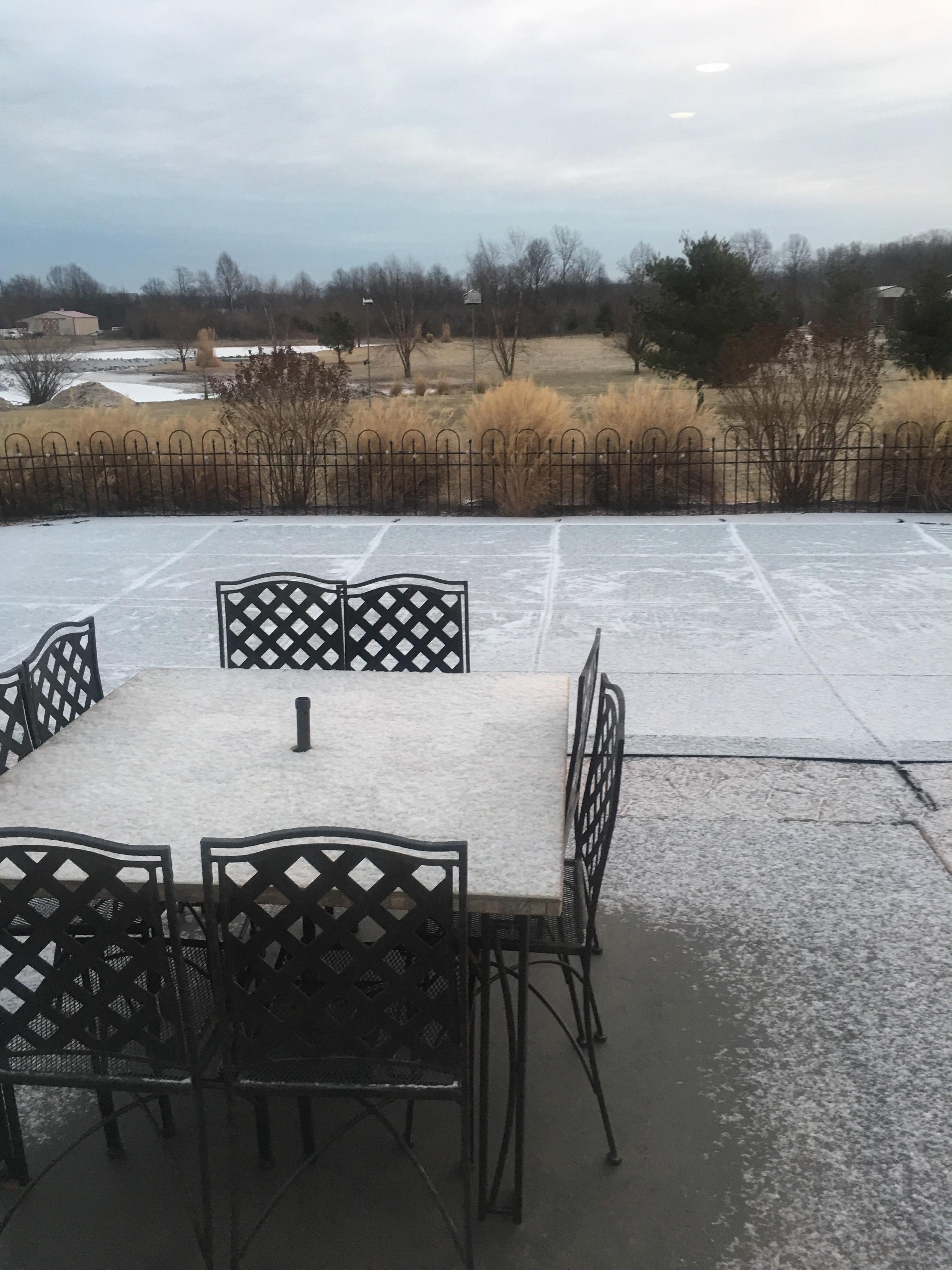
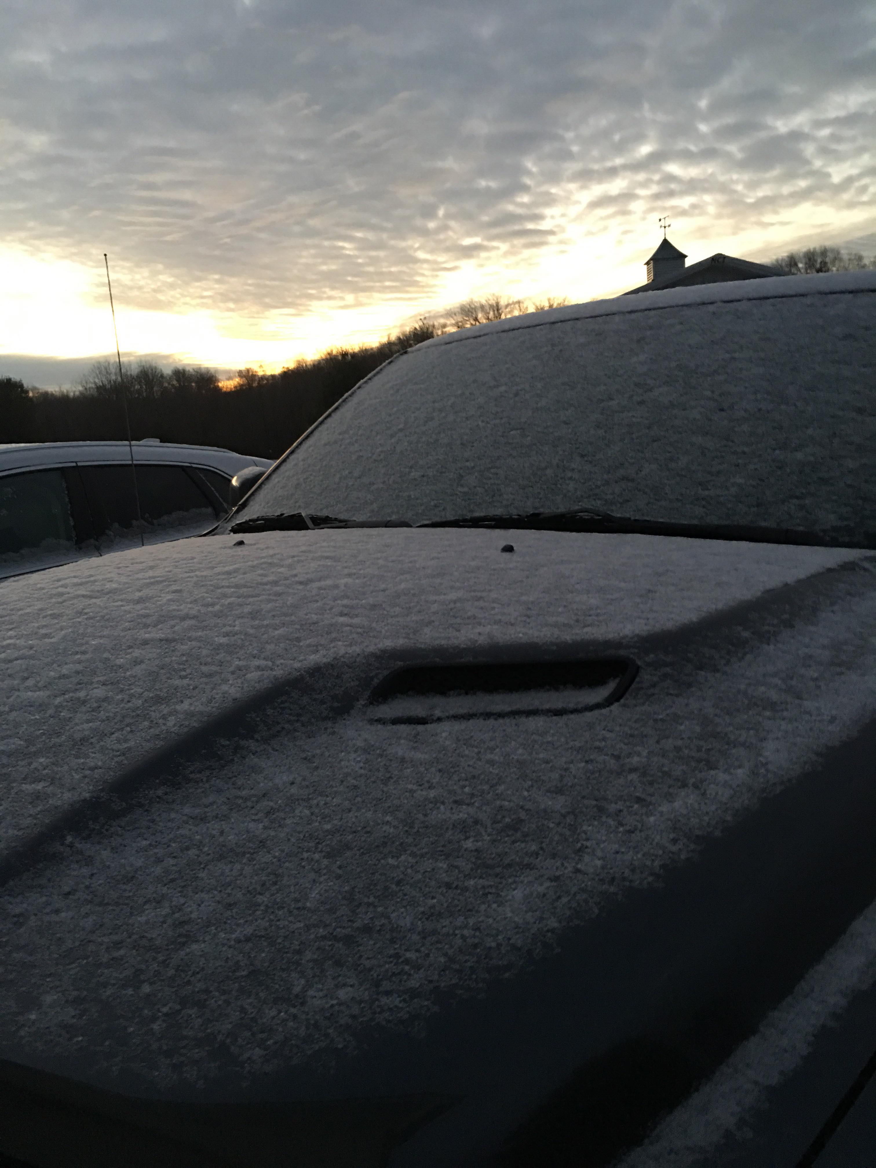
We’ve had some flurries and snow showers over the past 12 hours. A few locations even picked up a dusting of snow.
Cody Simmerman took these photographs. Marion, Illinois.
.
.
.
The snow flurries and snow showers are on the way out. Some clouds will remain today. We should have some clearing as we move into the afternoon.
It will remain cold today with highs in the twenties. Wind chills will be in the upper teens to middle twenties. Cold.
Dry weather is anticipated tonight into Saturday afternoon. Chilly temperatures.
A disturbance will push into the region late Saturday night and especially Sunday and Sunday night. There remain some questions on the timing of the precipitations arrival. It is possible that the region will remain dry through Sunday morning.
For now, I do have slight chances of freezing rain and sleet late Saturday night over southeast Missouri. Chances then ramp up as we move into Sunday and Sunday night.
Confidence on the type of precipitation is rather low. Temperature profiles may end up resulting in all types of precipitation. Freezing rain, sleet, snow, and rain.
The trends in guidance have been for colder temperature profiles. With that said, I am not overly confident on how this plays out.
Plan on the possibility of icy roads late Saturday night and especially Sunday and Sunday night.
Do not focus on amounts. Focus on impacts. Impacts will be a chance of icy roads for at least portions of the region.
Road and ground temperatures are very cold. Any light rain or freezing rain would quickly cause icy roadways. It will take time for road surfaces and other surfaces to warm. Even if temperatures rise above freezing that does not mean rain won’t freeze upon contact with the cold surfaces.
Bottom line: Pay attention to updated forecasts. Winter weather advisories may need to be issued for portions of the region on Sunday and Sunday night.
The precipitation should turn to all rain Sunday night.
Monitor updates concerning Sunday’s weather and plan on the potential of icy roadways.
Temperatures should slowly warm on Sunday night and Monday. Temperatures should rise above freezing across the region by Monday morning.
A moderating trend will occur next week. The bitterly cold air will be replaced with somewhat milder air. Don’t plan on warm weather. It just won’t be as cold. Daytime highs in the 40’s and overnights lows in the 20’s and 30’s. Not too bad considering what we just went through.
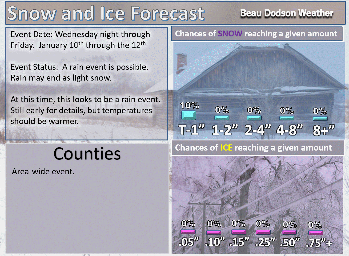
I do have rain in the forecast by Wednesday night and Thursday. That rain may end as a brief period of frozen precipitation on Thursday night. At this time, the chances appear low for accumulating snow or ice. This is in the long range. Monitor updates.
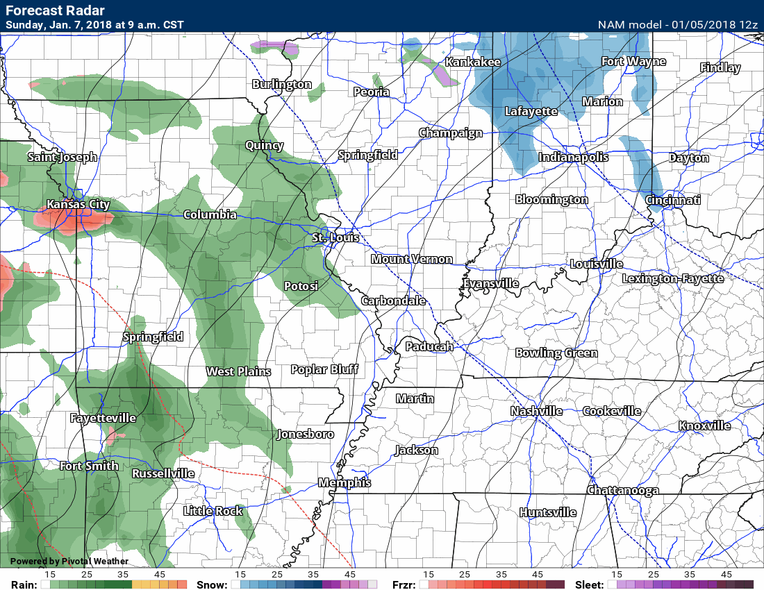
Here is the future-cast radar from the NAM model guidance. This is for Sunday and Sunday night. Green would be rain. Blue is snow. Other colors are sleet and freezing rain. You can see a mixture in our local area.
Don’t focus too much on exactly where the green, blue, and other colors are. Even in the rain areas we could have icy roads. Roads are very cold. Temperatures may rise above freezing but road surfaces will take longer to warm. This raises concerns about icy roadways.
Monitor updates.
Time stamp upper left.
.
.
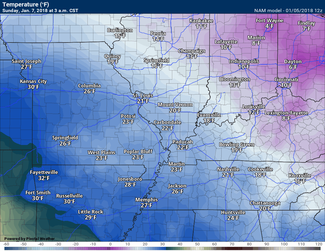
Here is the NAM temperature forecast for Sunday. The GFS model is warmer. NAM is colder.
.
.
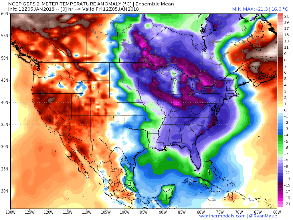
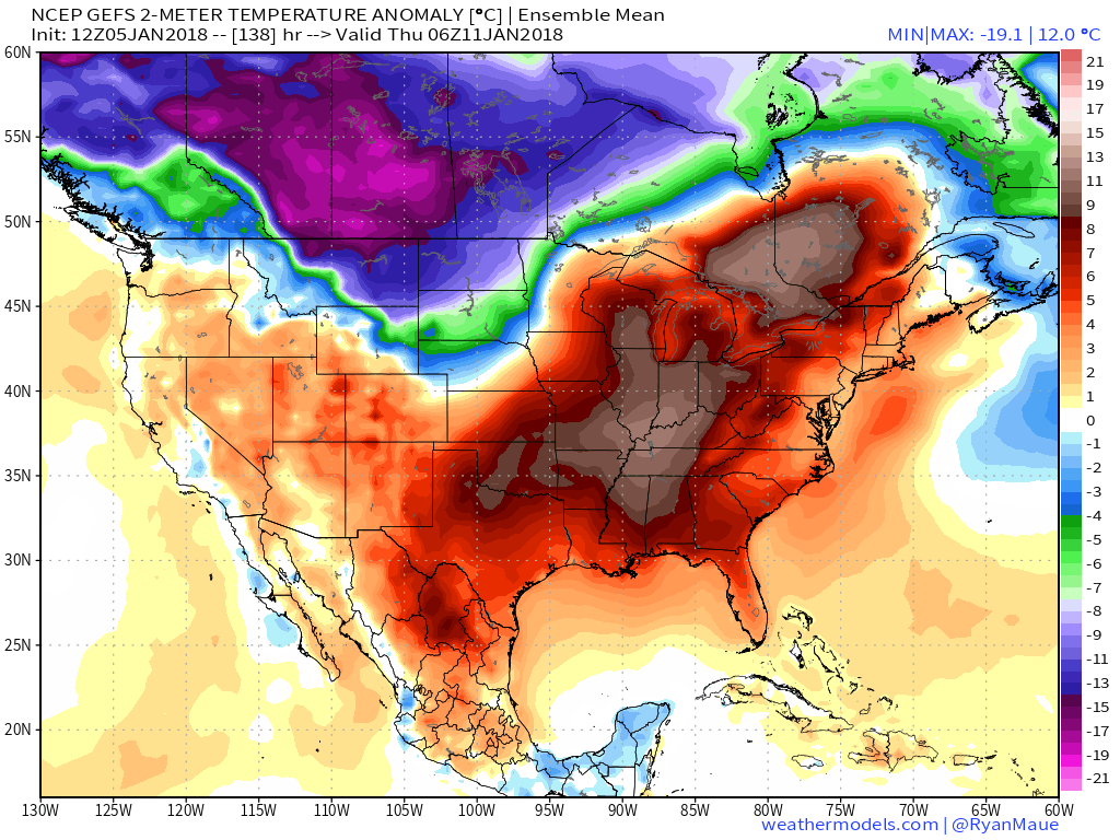
Beau’s Winter Weather Outlook
Temperature departure map for today. Cold! Look at the second map. That is for next Wednesday. We might hit 50 degrees.
.
.
.
.
It is important to remember that this pattern is fluid. There is always going to be lower than normal confidence, during the winter months, for the forecast past day three or four.
.
.
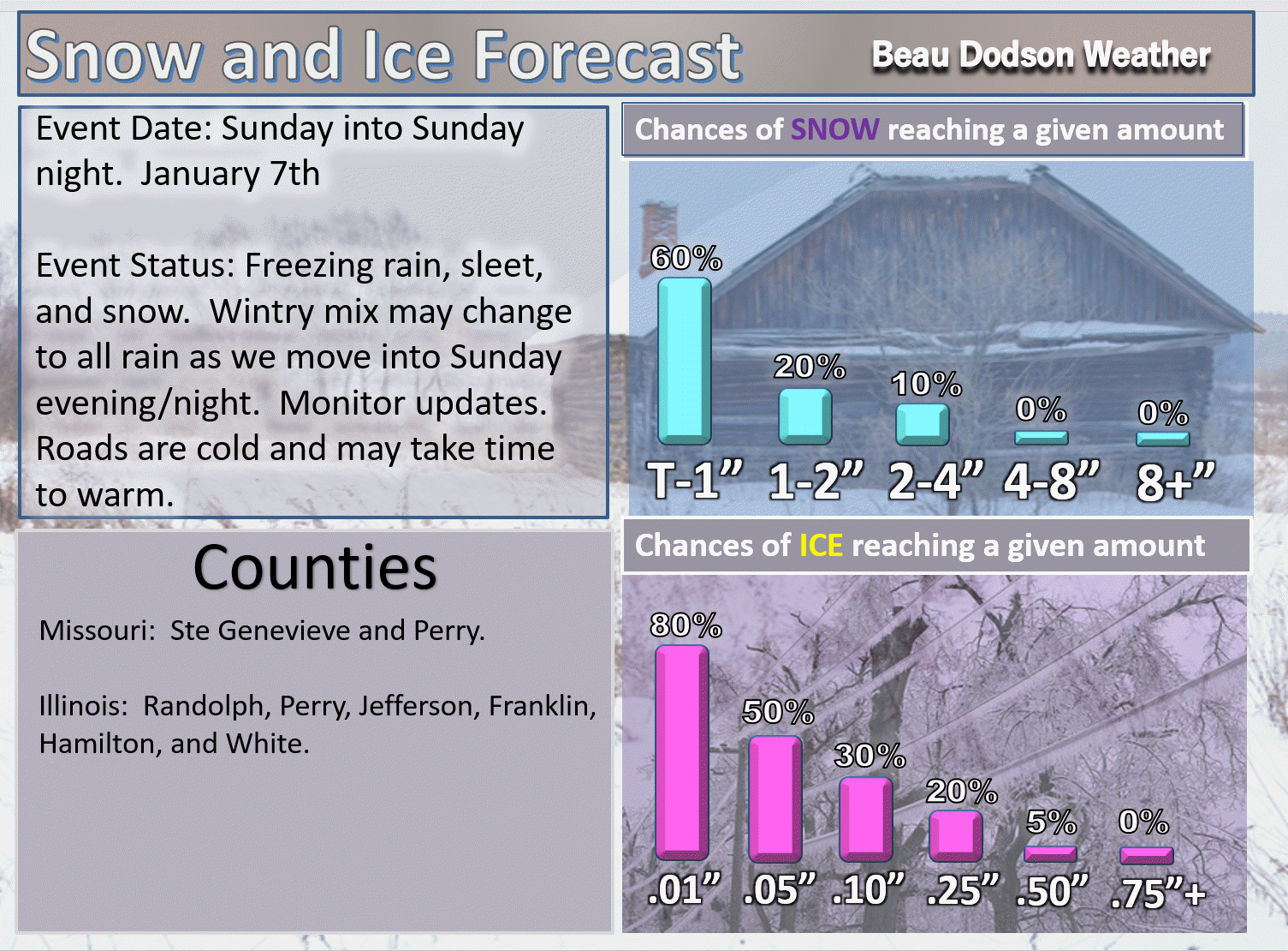
Here is my latest snow probability map for the week ahead.
The larger system arrives on Sunday. A mixture of freezing rain, sleet, and snow is likely to develop Sunday morning and afternoon. Icy roads are possible. The frozen precipitation could turn to rain, although this remains uncertain. Monitor updates.
Remember, it does not take much freezing rain to cause problems. A trace can cause icy roads.
Don’t focus on amounts. Focus on impacts.
T-1″ means a trace to one inch.
.
.
The next event arrives towards the middle/end of next week. Most likely a rain event. Rain may end as wintry mix or snow.
.
.


We offer regional radars and local city radars – if a radar does not update then try another one. Occasional browsers need their cache cleared. You may also try restarting your browser. This will usually fix any problems.
During the winter you can track snow and ice by clicking the winterize button on the local city view interactive radars.
You may email me at beaudodson@usawx.com
Interactive Weather Radar Page. Choose the city nearest your location: Click this link
National interactive radar: Click this link.