.
Click one of the links below to take you directly to that section.
Do you have any suggestions or comments? Email me at beaudodson@usawx.com
A quick glance at the next seven days.

How much rain is anticipated over the next 48 hours? Click to enlarge.


.
The wind forecast

.
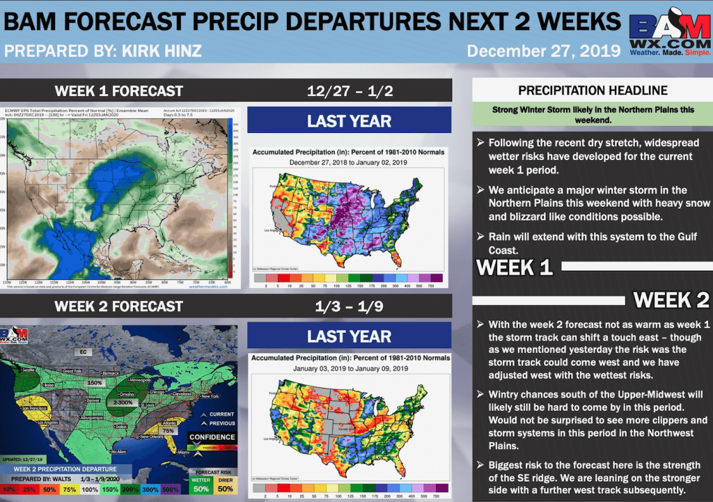
Saturday through Saturday
- Is lightning in the forecast? Yes. The highest chance of lightning will arrive on Saturday afternoon into Saturday night. Lightning is also possible on Sunday.
- Are severe thunderstorms in the forecast? Monitor. I am closely watching Saturday night into Sunday evening. A few thunderstorms could produce strong wind gusts. There is a low-end tornado risk. Overall, this is not a perfect set-up for severe weather. Monitor updates. It only takes one severe thunderstorm to cause problems.
* The NWS officially defines a severe thunderstorm as a storm with 58 mph wind or greater, 1″ hail or larger, and/or tornadoes - Is flash flooding in the forecast? Monitor. Locally heavy rain is likely Saturday night into Sunday evening. Pockets of flooding could occur. The highest chance of that would be over Kentucky and Tennessee.
- Is ACCUMULATING snow or ice in the forecast? No.
- Will wind chill values drop below 10 degrees? No
.
..
.
What changes might occur in the forecast? Important forecast notes.
Rain chances on Thursday will need to be monitored.
.
December 28, 2019
How confident am I that this days forecast will verify? High confidence.
Saturday’s Forecast: Mostly cloudy. Breezy. A chance of an AM shower. Shower and thunderstorm chances ramp up as we move deeper into the afternoon and evening hours.
What is the chance of precipitation? MO ~ 70% IL ~ 60% KY ~ 60% TN ~ 70%
Temperature range: MO Bootheel 63° to 66° SE MO 62° to 65° South IL 62° to 65° Northwest KY (near Indiana border) 62° to 65° West KY 64° to 66° NW TN 64° to 66°
Wind direction and speed: South and southeast at 8 to 16 mph with gusts to 25 mph.
Wind chill or heat index (feels like) temperature forecast: 58° to 64°
Coverage of precipitation: Scattered AM. Becoming more numerous during the afternoon and evening.
What impacts are anticipated from the weather? Wet roadways. Lightning,
Should I cancel my outdoor plans? Have a plan B and monitor updates
UV Index: 1 Low
Sunrise: 7:09 AM
Sunset: 4:45 PM
.
Saturday night Forecast: Gusty winds. Showers and thunderstorms. Locally heavy rain. A few storms could produce gusty wind.
What is the chance of precipitation? MO ~ 100% IL ~ 100% KY ~ 100% TN ~ 100%
Temperature range: MO Bootheel 58° to 62° SE MO 56° to 60° South IL 58° to 62° Northwest KY (near Indiana border) 58° to 62° West KY 58° to 62° NW TN 58° to 62°
Wind direction and speed: South and southeast at 15 to 30 mph. Gusty winds.
Wind chill or heat index (feels like) temperature forecast: 42° to 45°
Coverage of precipitation: Widespread
What impacts are anticipated from the weather? Wet roadways. Lightning. Locally heavy rain. A few strong thunderstorms with gusty wind.
Should I cancel my outdoor plans? Have a plan B
Moonrise: 9:12 AM
Moonset: 7:14 PM
The phase of the moon: Waxing Crescent
.
December 29, 2019
How confident am I that this days forecast will verify? High confidence.
Sunday’s Forecast: Showers and thunderstorms. Locally moderate to heavy rain.
What is the chance of precipitation? MO ~ 70% IL ~ 90% KY ~ 100% TN ~ 100%
Temperature range: MO Bootheel 63° to 66° SE MO 62° to 65° South IL 62° to 65° Northwest KY (near Indiana border) 62° to 65° West KY 64° to 66° NW TN 64° to 66°
Wind direction and speed: South and southwest at 10 to 25 mph and gusty.
Wind chill or heat index (feels like) temperature forecast: 55° to 60°
Coverage of precipitation: Widespread
What impacts are anticipated from the weather? Wet roadways. Lightning. Locally heavy rain. A few thunderstorms could produce strong wind gusts.
Should I cancel my outdoor plans? Have a plan B.
UV Index: 1 Low
Sunrise: 7:09 AM
Sunset: 4:46 PM
.
Sunday night Forecast: Cloudy and turning colder. Rain likely. Breezy. Rain tapering off west to east.
What is the chance of precipitation? MO ~ 50% IL ~ 70% KY ~ 80% TN ~ 80%
Temperature range: MO Bootheel 34° to 38° SE MO 33° to 36° South IL 33° to 36° Northwest KY (near Indiana border) 34° to 36° West KY 34° to 36° NW TN 34° to 38°
Wind direction and speed: Southwest to west at 10 to 20 mph and gusty.
1Wind chill or heat index (feels like) temperature forecast: 25° to 30°
Coverage of precipitation: Widespread before midnight. Ending west to east overnight.
What impacts are anticipated from the weather? Wet roadways. Some locally heavy downpours. Lightning is possible early in the night.
Should I cancel my outdoor plans? Yes. Have a plan B.
Moonrise: 9:50 am
Moonset: 8:13 pm
The phase of the moon: Waxing Crescent
.
December 30, 2019
How confident am I that this days forecast will verify? Medium confidence.
Monday’s Forecast: A mix of sun and clouds. Cooler.
What is the chance of precipitation? MO ~ 0% IL ~ 0% KY ~ 0% TN ~ 0%
Temperature range: MO Bootheel 45° to 50° SE MO 44° to 46° South IL 44° to 46° Northwest KY (near Indiana border) 44° to 46° West KY 44° to 46° NW TN 46° to 48°
Wind direction and speed: West and southwest at 10 to 20 mph.
Wind chill or heat index (feels like) temperature forecast: 38° to 45°
Coverage of precipitation: None
What impacts are anticipated from the weather? None
Should I cancel my outdoor plans? No
UV Index: 2 Low
Sunrise: 7:09 AM
Sunset: 4:46 PM
.
Monday night Forecast: Mostly clear. Chilly.
What is the chance of precipitation? MO ~ 0% IL ~ 0% KY ~ 0% TN ~ 0%
Temperature range: MO Bootheel 28° to 32° SE MO 28° to 30° South IL 28° to 28° Northwest KY (near Indiana border) 28° to 30° West KY 28° to 30° NW TN 28° to 32°
Wind direction and speed: West and northwest at 7 to 14 mph with gusts to 20 mph.
1Wind chill or heat index (feels like) temperature forecast: 20° to 30°
Coverage of precipitation: None
What impacts are anticipated from the weather? None
Should I cancel my outdoor plans? No
Moonrise: 10:24 am
Moonset: 9:12 pm
The phase of the moon: Waxing Crescent
.
December 31, 2019
How confident am I that this days forecast will verify? Medium confidence.
Tuesday’s Forecast: Partly to mostly sunny.
What is the chance of precipitation? MO ~ 0% IL ~ 0% KY ~ 0% TN ~ 0%
Temperature range: MO Bootheel 44° to 48° SE MO 44° to 48° South IL 44° to 48° Northwest KY (near Indiana border) 44° to 48° West KY 44° to 48° NW TN 46° to 50°
Wind direction and speed: West and northwest at 7 to 14 mph with gusts to 20 mph
Wind chill or heat index (feels like) temperature forecast: 40° to 45°
Coverage of precipitation: None
What impacts are anticipated from the weather? None.
Should I cancel my outdoor plans? No
UV Index: 2 Low
Sunrise: 7:09 AM
Sunset: 4:47 PM
.
Tuesday night Forecast: Mostly clear. Chilly.
What is the chance of precipitation? MO ~ 0% IL ~ 0% KY ~ 0% TN ~ 0%
Temperature range: MO Bootheel 26° to 28° SE MO 25° to 28° South IL 25° to 28° Northwest KY (near Indiana border) 26° to 28° West KY 26° to 30° NW TN 28° to 32°
Wind direction and speed: West at 5 to 10 mph.
1Wind chill or heat index (feels like) temperature forecast: 24° to 30°
Coverage of precipitation: None
What impacts are anticipated from the weather? None
Should I cancel my outdoor plans? No
Moonrise: 10:55 AM
Moonset: 10:09 PM
The phase of the moon: Waxing Crescent
.
January 1, 2019
How confident am I that this days forecast will verify? Medium confidence.
Wednesday’s Forecast: Increasing clouds from the southwest.
What is the chance of precipitation? MO ~ 10% IL ~ 10% KY ~ 10% TN ~ 10%
Temperature range: MO Bootheel 48° to 52° SE MO 46° to 48° South IL 46° to 48° Northwest KY (near Indiana border) 46° to 48° West KY 46° to 50° NW TN 48° to 52°
Wind direction and speed: Southwest at 5 to 10 mph
Wind chill or heat index (feels like) temperature forecast: 45° to 50°
Coverage of precipitation: None
What impacts are anticipated from the weather? None.
Should I cancel my outdoor plans? No
UV Index: 2 Low
Sunrise: 7:10 AM
Sunset: 4:48 PM
.
Wednesday night Forecast: Becoming cloudy. A chance of a shower.
What is the chance of precipitation? MO ~ 30% IL ~ 30% KY ~ 30% TN ~ 30%
Temperature range: MO Bootheel 38° to 42° SE MO 36° to 40° South IL 36° to 40° Northwest KY (near Indiana border) 36° to 40° West KY 36° to 40° NW TN 38° to 42°
Wind direction and speed: Southwest at 5 to 10 mph
1Wind chill or heat index (feels like) temperature forecast: 35° to 40°
Coverage of precipitation: Widely scattered
What impacts are anticipated from the weather? Wet roadways.
Should I cancel my outdoor plans? No. Monitor updates.
Moonrise: 11:22 AM
Moonset: 11:05 PM
The phase of the moon: Waxing Crescent
.
January 2, 2019
How confident am I that this days forecast will verify? Low confidence.
Thursday’s Forecast: Cloudy with rain showers.
What is the chance of precipitation? MO ~ 60% IL ~ 60% KY ~ 60% TN ~ 60%
Temperature range: MO Bootheel 48° to 52° SE MO 46° to 50° South IL 46° to 50° Northwest KY (near Indiana border) 46° to 50° West KY 46° to 52° NW TN 48° to 52°
Wind direction and speed: South at 7 to 14 mph
Wind chill or heat index (feels like) temperature forecast: 48° to 52°
Coverage of precipitation: Scattered to perhaps numerous
What impacts are anticipated from the weather? Wet roadways.
Should I cancel my outdoor plans? Have a plan B and monitor updates.
UV Index: 2 Low
Sunrise: 7:10 AM
Sunset: 4:48 PM
.
Thursday night Forecast: Cloudy. A chance of rain showers.
What is the chance of precipitation? MO ~ 40% IL ~ 40% KY ~ 40% TN ~ 40%
Temperature range: MO Bootheel 38° to 42° SE MO 36° to 40° South IL 36° to 40° Northwest KY (near Indiana border) 36° to 40° West KY 36° to 40° NW TN 38° to 42°
Wind direction and speed: West at 5 to 10 mph
1Wind chill or heat index (feels like) temperature forecast: 35° to 40°
Coverage of precipitation: Widely scattered
What impacts are anticipated from the weather? Wet roadways.
Should I cancel my outdoor plans? Have a plan B and monitor updates.
Moonrise: 11:49 AM
Moonset: 12:01 PM
The phase of the moon: Waxing Crescent
.
January 3, 2019
How confident am I that this days forecast will verify? Medium confidence.
Friday’s Forecast: Quite a few clouds. A chance of a shower.
What is the chance of precipitation? MO ~ 30% IL ~ 30% KY ~ 30% TN ~ 30%
Temperature range: MO Bootheel 53° to 56° SE MO 52° to 54° South IL 52° to 54° Northwest KY (near Indiana border) 52° to 54° West KY 52° to 54° NW TN 52° to 54°
Wind direction and speed: West at 6 to 12 mph
Wind chill or heat index (feels like) temperature forecast: 48° to 54°
Coverage of precipitation: Widely scattered
What impacts are anticipated from the weather? Wet roadways.
Should I cancel my outdoor plans? No
UV Index: 2 Low
Sunrise: 7:10 AM
Sunset: 4:49 PM
.
Friday night Forecast: Decreasing clouds. Cooler.
What is the chance of precipitation? MO ~ 0% IL ~ 0% KY ~ 0% TN ~ 0%
Temperature range: MO Bootheel 30° to 34° SE MO 28° to 32° South IL 28° to 32° Northwest KY (near Indiana border) 28° to 34° West KY 28° to 32° NW TN 30° to 34°
Wind direction and speed: Northwest at 5 to 10 mph
1Wind chill or heat index (feels like) temperature forecast: 26° to 32°
Coverage of precipitation: None
What impacts are anticipated from the weather? None
Should I cancel my outdoor plans? No
Moonrise: 12:14 PM
Moonset: 12:01 AM
The phase of the moon: First Quarter
.

.
- Damp conditions Friday night into Saturday night/Sunday morning.
- Locally heavy rain Saturday night.
.
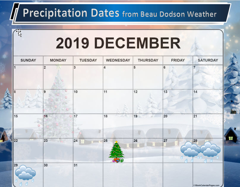
These are dates that may have precipitation. Monitor the trends in the forecast.
Anything past day seven is low confidence.
The icon can mean rain or snow.
Click to enlarge these graphics.

![]()
![]()
Graphic-cast
Click here if you would like to return to the top of the page.
Illinois
During active weather check my handwritten forecast towards the top of the page.

.
Kentucky
During active weather check my handwritten forecast towards the top of the page.


.
Tennessee
During active weather check my handwritten forecast towards the top of the page.


.
Today through January 3rd: A few of the thunderstorms Saturday afternoon and night could produce 50+ mph wind gusts. Lightning. There is a low-end risk of a few storms becoming severe with damaging wind gusts. The tornado risk is low, but not zero.
A few of the thunderstorms on Sunday between 11 AM and 8 PM could produce strong and gusty winds, as well. The chance on Sunday will shift further east. A low-end tornado risk, as well.
Overall, this is not a perfect set-up for severe thunderstorms. With that said, it only takes one severe thunderstorm to ruin the day. Monitor my app updates.
.
Today’s outlook (below).
Light green is where thunderstorms may occur but should be below severe levels.
Dark green is a level one risk. Yellow is a level two risk. Orange is a level three (enhanced) risk. Red is a level four (moderate) risk. Pink is a level five (high) risk.
One is the lowest risk. Five is the highest risk.
A severe storm is one that produces 58 mph wind or higher, quarter size hail, and/or a tornado.

The black outline is our local area.

.
Tomorrow’s severe weather outlook.


.

.
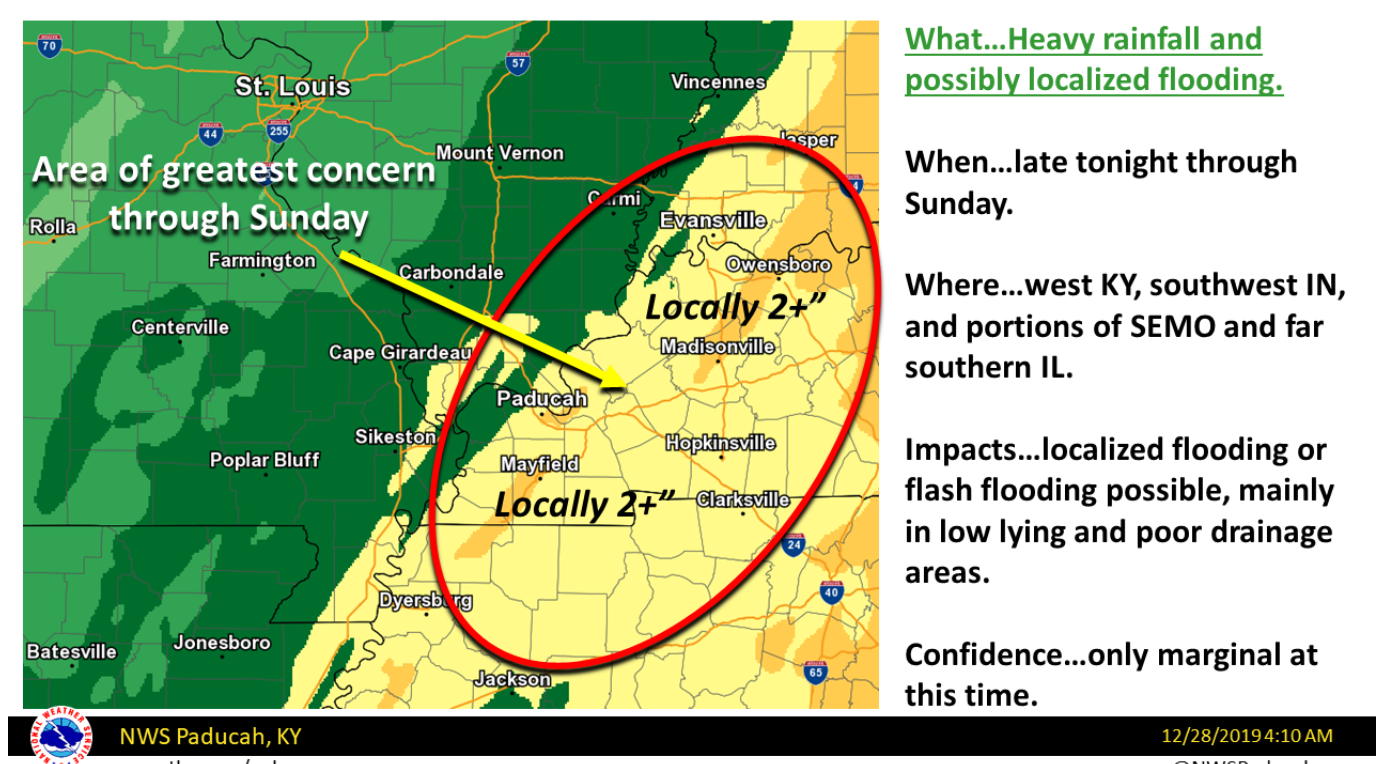
Here is the going forecast for our local area (for rain totals). Click image to enlarge.
.
The images below are from the WPC. Their totals are a bit lower than our current forecast. I wanted to show you the comparison.
24-hour precipitation outlook.
.

.
48-hour precipitation outlook.
.
.
Days one through seven added together. Seven-day rainfall totals.


.
- The main weather story will be the wind and rain this weekend.
- Dry Monday, Tuesday, and Wednesday.
- Another rain-maker on Thursday.
.
![]()
..
Advice:
Monitor updates concerning locally heavy rain, thunderstorms, and strong and gusty winds on Saturday afternoon, night, and into Sunday.
.
Weather Forecast Analysis
The main weather story is the ongoing rain event.
We already have showers on the radar as of Saturday morning. The rain coverage will dramatically increase tonight into Sunday.
See our local interactive radars for the most up to date location of the rain showers/storms.
There will be two waves of rain.
Wave one will be today into Sunday morning. The second wave of precipitation will move north/northeast out of Arkansas and Tennessee on Sunday afternoon and evening. See the future-cast radars below.
Locally heavy rain will occur with this event. A widespread one to two inches of rain is anticipated. Pockets of two to three+ inches of rain are likely across western Tennessee into Kentucky.
There could be some ponding of water on roadways. Some low-land flooding is also likely. You can expect sharp rises on area streams and rivers.
Here is a general idea of what you can expect as far as rain totals. It will vary, of course. Thunderstorms can always enhance rain totals.
There is a small risk that a few storms could become severe. A lot of severe weather ingredients are missing from this event. With that said, a few of the thunderstorms could produce strong and gusty winds.
The tornado risk is low. It isn’t a zero risk. It is, however, low. There is not much CAPE to tap into. CAPE is basically energy that thunderstorms feed on.
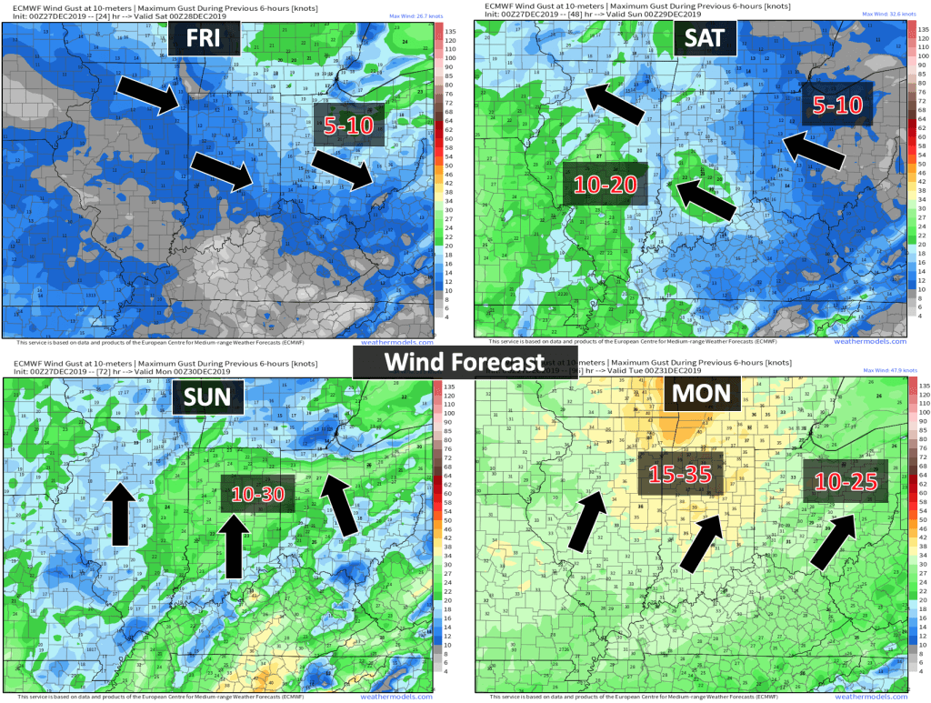
Outside of thunderstorms, we will also have strong and gusty winds because of the tight barometric pressure gradient. The center of the low pressure will pass well to our north. It will be a tight low. A deep low. That means strong winds.
As you know, we have low and high pressure in the atmosphere. The difference between the two creates wind.
This is a strong winter storm (blizzard) well to our north. A rain-maker for our region.
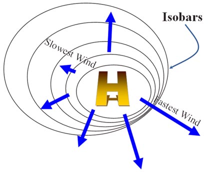
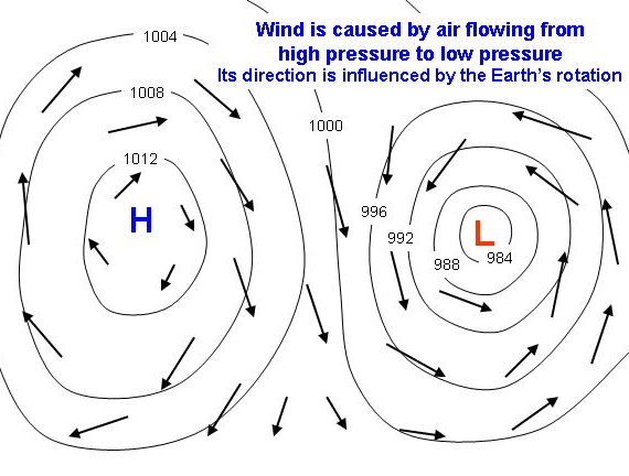
I drew red lines over some of the isobars. See how tightly packed they are? That will mean gusty wind in our region. Many areas of the central United States will experience the same.

.
Non-thunderstorm gradient wind gusts this weekend should exceed 35 mph.
Here is the wind gust forecast animation. Time-stamp upper left. Click the images on the blog page to enlarge them.
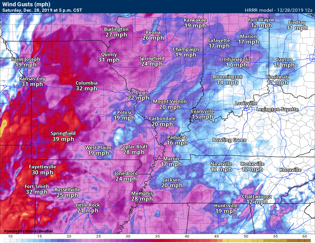
Any thunderstorms that develop could also produce strong and gusty winds.
.
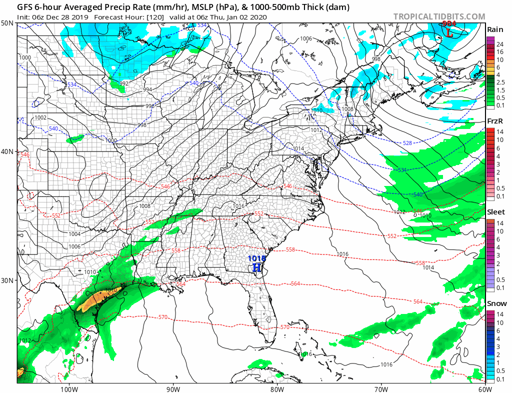
I am watching Thursday and Friday as another system attempts to bring rain back to the region. The track of this one is still in question.
The GFS takes it fairly far south. Other models are further north.
.
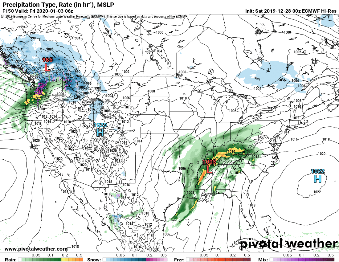
Here is the EC model. It is further north and west with the center of low pressure. It brings more rain to our region.
I suspect the GFS will trend north and west, as well.
.
Christmas was certainly mild. How mild was it?
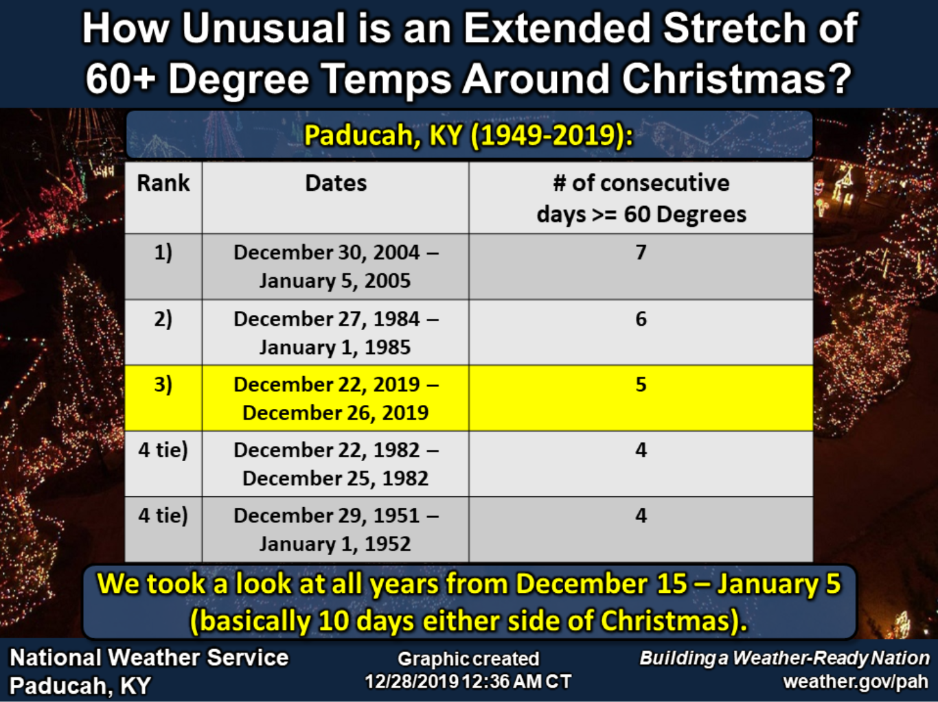
.
SHORT and LONG RANGE SNOW OUTLOOK:
I am currently not tracking any winter storms for our local area.
.
 .
.
Click here if you would like to return to the top of the page.
Again, as a reminder, these are models. They are never 100% accurate. Take the general idea from them.
What should I take from these?
- The general idea and not specifics. Models usually do well with the generalities.
- The time-stamp is located in the upper left corner.
.
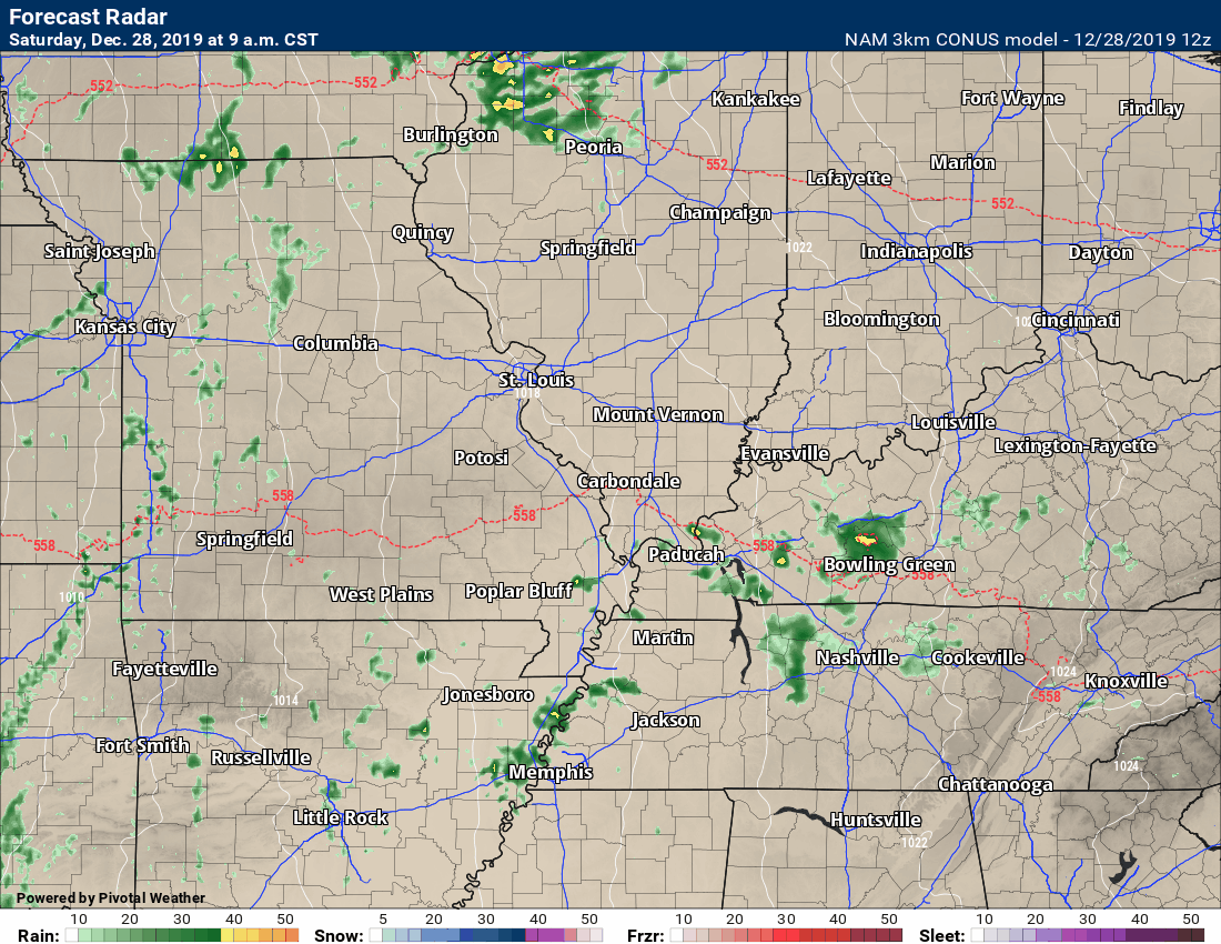
Here is the NAM 3K model guidance future-cast radar.
Time-stamp upper left. You can see the timing of the showers and locally heavy thunderstorms.
The heaviest rain will occur Saturday night into Sunday afternoon.
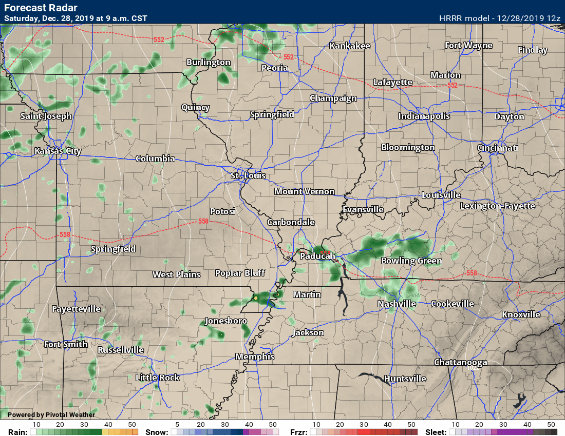
Here is the Hrrr future-cast radar. Different model. Each model can have some differences.
The brighter colors represent heavier showers and thunderstorms.
The heaviest rain will occur Saturday night into Sunday afternoon.
.

.
Click here if you would like to return to the top of the page.
.
Average high temperatures for this time of the year are around 45 degrees.
Average low temperatures for this time of the year are around 29 degrees.
Average precipitation during this time period ranges from 0.90″ to 1.10″
Yellow and orange colors are above average temperatures. Red is much above average. Light blue and blue are below-average temperatures. Green to purple colors represents much below-average temperatures.
This outlook covers December 27th through January 3rd
Click on the image to expand it.
.
The precipitation forecast is PERCENT OF AVERAGE. Brown is below average. Green is above average. Blue is much above average.
.

Average low temperatures for this time of the year are around 26 degrees
Average precipitation during this time period ranges from 1.00″ to 1.10″
.
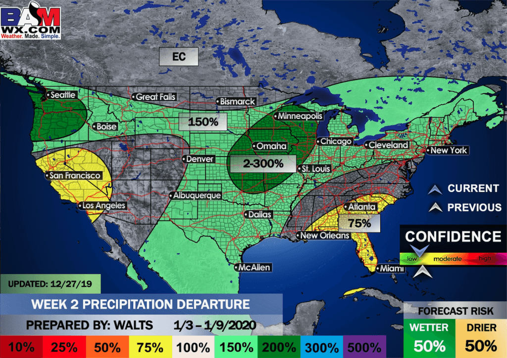
This outlook covers January 3rd through the 9th
Click on the image to expand it.

.
The precipitation forecast is PERCENT OF AVERAGE. For example, if your average rainfall is 1.00″ and the graphic shows 25%, then that would mean 0.25″ of rain is anticipated.
.
.

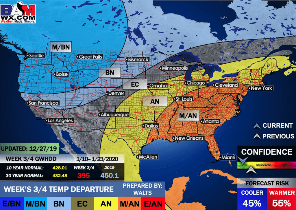
EC = Equal chances of above or below average
BN= Below average
M/BN = Much below average
AN = Above average
M/AN = Much above average
E/AN = Extremely above average
Average low temperatures for this time of the year are around 25 degrees
Average precipitation during this time period ranges from 1.90″ to 2.20″
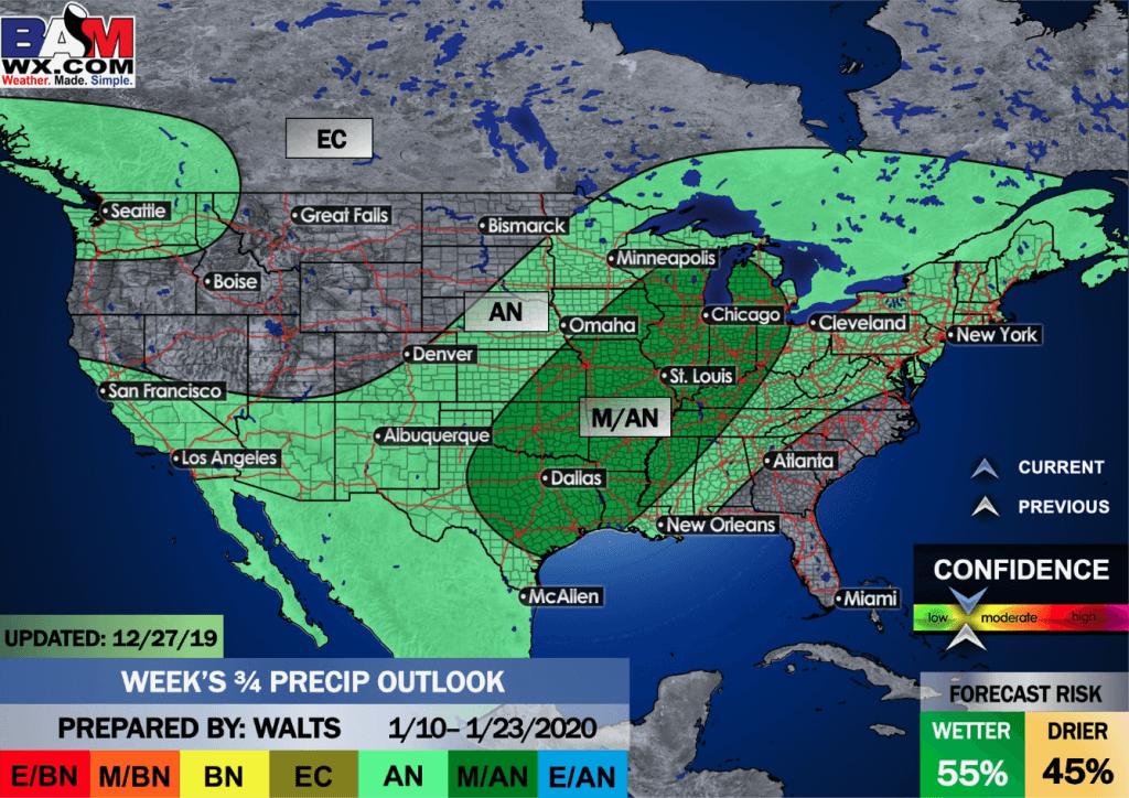
This outlook covers January 10th through the 23rd
Click on the image to expand it.
.
.
Precipitation outlook
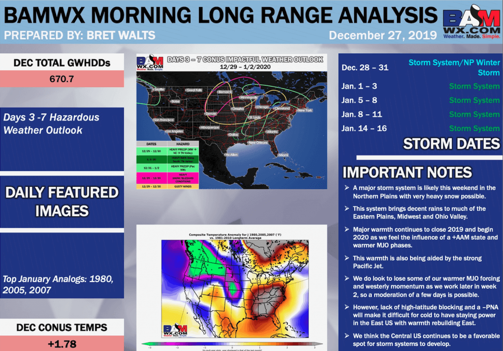
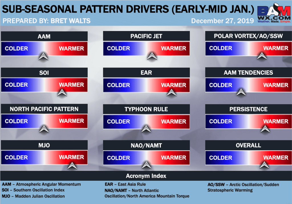
LONG RANGE DISCUSSION
Key Points: This was written by the BAMwx team. I don’t edit it.
Click to enlarge all of the images below
These graphics are updated Monday through Friday between 8:30 AM and 9:30 AM.
NOTE: These may not be updated on Saturday and Sunday.
.


![]()

Great news! The videos are now found in your Weathertalk app and on the WeatherTalk website.
These are bonus videos for subscribers.
The app is for subscribers. Subscribe at www.weathertalk.com/welcome then go to your app store and search for WeatherTalk
Subscribers, PLEASE USE THE APP. ATT and Verizon are not reliable during severe weather. They are delaying text messages.
The app is under WeatherTalk in the app store.

Apple users click here

Android users click here
.

Radar Link: Interactive local city-view radars & regional radars.
You will find clickable warning and advisory buttons on the local city-view radars.
If the radar is not updating then try another one. If a radar does not appear to be refreshing then hit Ctrl F5. You may also try restarting your browser.
Not working? Email me at beaudodson@usawx.com
National map of weather watches and warnings. Click here.
Storm Prediction Center. Click here.
Weather Prediction Center. Click here.
.

Live lightning data: Click here.
.

Interactive GOES R satellite. Track clouds. Click here.
GOES 16 slider tool. Click here.
College of Dupage satellites. Click here
.

Here are the latest local river stage forecast numbers Click Here.
Here are the latest lake stage forecast numbers for Kentucky Lake and Lake Barkley Click Here.
.
.
Find Beau on Facebook! Click the banner.

.
Find Beau on Twitter! Share your weather photos! @beaudodson


Click here if you would like to return to the top of the page.
Did you know that a portion of your monthly subscription helps support local charity projects? Not a subscriber? Becoming one at www.weathertalk.com
You can learn more about those projects by visiting the Shadow Angel Foundation website and the Beau Dodson News website.
