January 21, 2018
Updated at 1 PM

.

We offer regional radars and local city radars – if a radar does not update then try another one. Occasional browsers need their cache cleared. You may also try restarting your browser. This will usually fix any problems.
During the winter you can track snow and ice by clicking the winterize button on the local city view interactive radars.
You may email me at beaudodson@usawx.com
Interactive Weather Radar Page. Choose the city nearest your location: Click this link
National interactive radar: Click this link.
.
January 21, 2018
Sunday Forecast Details
Forecast: Cloudy. Patchy light showers possible. Mild.
Temperatures: MO ~ 55 to 60 IL ~ 54 to 58 KY ~ 54 to 58
What is the chance of precipitation? MO ~ 20% IL ~ 20% KY ~ 20% TN ~ 20%
Coverage of precipitation: Patchy light showers possible.
Wind chill values: N/A
Accumulating snow or ice: No
Winds: South at 8 to 16 mph and gusty
What impacts are anticipated from the weather? Wet roadways.
My confidence in the forecast verifying: High
Is severe weather expected? No
The NWS defines severe weather as 58 mph wind or great, 1″ hail or larger, and/or tornadoes
Should I cancel my outdoor plans? No, but check radars.
.
Sunday Night Forecast Details:
Forecast: Cloudy. Temperatures holding steady. Increasing rain chances overnight (mostly late). A thunderstorm possible. Gusty winds.
Temperatures: MO ~ 54 to 58 IL ~ 54 to 58 KY ~ 54 to 58
What is the chance of precipitation? MO ~ 100% (mostly after 11 PM) IL ~ 90% (mostly after 2 AM) KY ~ 90% (mostly after 3 AM) TN ~ 100% (mostly late)
Coverage of precipitation: Becoming widespread.
Wind chill values: N/A
Accumulating snow or ice: No
Winds: South wind at 10 to 20 mph with gusts to 35 mph.
What impacts are anticipated from the weather? Wet roadways. Lightning possible.
My confidence in the forecast verifying: High
Is severe weather expected? Small risk of damaging winds across southeast Missouri.
The NWS defines severe weather as 58 mph wind or great, 1″ hail or larger, and/or tornadoes
Should I cancel my outdoor plans: Have a plan B
.
January 22, 2018
Monday Forecast Details
From 11 AM onward
Forecast: Breezy and mild. A 30% of additional showers and thunderstorms. A mix of sun and clouds. Clearing from west to east.
Temperatures: MO ~ 58 to 63 and temps may fall late in the day IL ~ 58 to 62 during the morning and then falling late in the day KY ~ 60 to 65
What is the chance of precipitation? MO ~ 30% IL ~ 30% KY ~ 30% TN ~ 30%
Coverage of precipitation: Isolated during the afternoon.
Wind chill values: N/A
Accumulating snow or ice: No
Winds: South and southwest at 15 to 35 mph with higher gusts likely.
What impacts are anticipated from the weather? Wet roadways. Lightning possible. Strong winds.
My confidence in the forecast verifying: High
Is severe weather expected? Small chance of high winds with any storms that form.
The NWS defines severe weather as 58 mph wind or great, 1″ hail or larger, and/or tornadoes
Should I cancel my outdoor plans? No, but check radars
.
Monday Night Forecast Details:
Forecast: Becoming cloudy. Windy. Colder. Patchy light rain or snow flurries possible overnight. No accumulation.
Temperatures: MO ~ 32 to 36 IL ~ 30 to 35 KY ~ 33 to 36
What is the chance of precipitation? MO ~ 20% IL ~ 20% KY ~ 20% TN ~ 20%
Coverage of precipitation: None to isolated
Wind chill values: 20 to 30
Accumulating snow or ice: No
Winds: West and southwest at 15 to 25 mph and gusty
What impacts are anticipated from the weather? Wet roads.
My confidence in the forecast verifying: High
Is severe weather expected? No
The NWS defines severe weather as 58 mph wind or great, 1″ hail or larger, and/or tornadoes
Should I cancel my outdoor plans: No, but check radars.
.
January 23, 2018
Tuesday Forecast Details
Forecast: A mix of sun and clouds. Cooler. A slight chance of a snow flurry or sprinkle.
Temperatures: MO ~ 38 to 44 IL ~ 38 to 44 KY ~ 40 to 45
What is the chance of precipitation? MO ~ 10% IL ~ 10% KY ~ 10% TN ~ 10%
Coverage of precipitation: Most likely none
Wind chill values: 28 to 38
Accumulating snow or ice: No
Winds: West wind 7 to 14 mph with gusts to 16 mph
What impacts are anticipated from the weather? None
My confidence in the forecast verifying: High
Is severe weather expected? No
The NWS defines severe weather as 58 mph wind or great, 1″ hail or larger, and/or tornadoes
Should I cancel my outdoor plans? No
.
Tuesday Night Forecast Details:
Forecast: A few evening clouds, otherwise becoming mostly clear. Colder.
Temperatures: MO ~ 25 to 30 IL ~ 25 to 30 KY ~ 25 to 30
What is the chance of precipitation? MO ~ 0% IL ~ 0% KY ~ 0% TN ~ 0%
Coverage of precipitation: Most likely none
Wind chill values: 20 to 30
Accumulating snow or ice: No
Winds: West at 7 to 14 mph
What impacts are anticipated from the weather? None
My confidence in the forecast verifying: High
Is severe weather expected? No
The NWS defines severe weather as 58 mph wind or great, 1″ hail or larger, and/or tornadoes
Should I cancel my outdoor plans: No
.
January 24, 2018
Wednesday Forecast Details
Forecast: Mostly sunny
Temperatures: MO ~ 45 to 50 IL ~ 45 to 50 KY ~ 45 to 50
What is the chance of precipitation? MO ~ 0% IL ~ 0% KY ~ 0% TN ~ 0%
Coverage of precipitation: None
Wind chill values: N/A
Accumulating snow or ice: N0
Winds: West winds at 5 to 10 mph
What impacts are anticipated from the weather? None
My confidence in the forecast verifying: High
Is severe weather expected? No
The NWS defines severe weather as 58 mph wind or great, 1″ hail or larger, and/or tornadoes
Should I cancel my outdoor plans? No
.
Wednesday Night Forecast Details:
Forecast: Mostly clear.
Temperatures: MO ~ 25 to 30 IL ~ 25 to 30 KY ~ 25 to 30
What is the chance of precipitation? MO ~ 0% IL ~ 0% KY ~ 0% TN ~ 0%
Coverage of precipitation: None
Wind chill values: N/A
Accumulating snow or ice: No
Winds: South and southwest winds at 5 to 10 mph
What impacts are anticipated from the weather? None
My confidence in the forecast verifying: High
Is severe weather expected? No
The NWS defines severe weather as 58 mph wind or great, 1″ hail or larger, and/or tornadoes
Should I cancel my outdoor plans: No
.
January 25, 2018
Thursday Forecast Details
Forecast: Mostly sunny.
Temperatures: MO ~ 50 to 55 IL ~ 50 to 55 KY ~ 50 to 55
What is the chance of precipitation? MO ~ 0% IL ~ 0% KY ~ 0% TN ~ 0%
Coverage of precipitation: None
Wind chill values: N/A
Accumulating snow or ice: No
Winds: South and southwest at 7 to 14 mph
What impacts are anticipated from the weather? None
My confidence in the forecast verifying: High
Is severe weather expected? No
The NWS defines severe weather as 58 mph wind or great, 1″ hail or larger, and/or tornadoes
Should I cancel my outdoor plans? No
.
Thursday Night Forecast Details:
Forecast: Clear.
Temperatures: MO ~ 34 to 38 IL ~ 34 to 38 KY ~ 34 to 38
What is the chance of precipitation? MO ~ 0% IL ~ 0% KY ~ 0% TN ~ 0%
Coverage of precipitation: None
Wind chill values: N/A
Accumulating snow or ice: No
Winds: Southwest and west at 6 to 12 mph
What impacts are anticipated from the weather? None
My confidence in the forecast verifying: High
Is severe weather expected? No
The NWS defines severe weather as 58 mph wind or great, 1″ hail or larger, and/or tornadoes
Should I cancel my outdoor plans: No
.
January 26, 2018
Friday Forecast Details
Forecast: Partly to mostly sunny. Increasing clouds late in the day. Mild.
Temperatures: MO ~ 54 to 56 IL ~ 54 to 56 KY ~ 54 to 56
What is the chance of precipitation? MO ~ 10% IL ~ 10% KY ~ 10% TN ~ 10%
Coverage of precipitation: None
Wind chill values: N/A
Accumulating snow or ice: No
Winds: South and southwest at 7 to 14 mph
What impacts are anticipated from the weather? None
My confidence in the forecast verifying: Medium
Is severe weather expected? No
The NWS defines severe weather as 58 mph wind or great, 1″ hail or larger, and/or tornadoes
Should I cancel my outdoor plans? No
.
Friday Night Forecast Details:
Forecast: Cloudy. Showers possible.
Temperatures: MO ~ 44 to 48 IL ~ 44 to 48 KY ~ 44 to 48
What is the chance of precipitation? MO ~ 40% IL ~ 40% KY ~ 40% TN ~ 40%
Coverage of precipitation: Scattered
Wind chill values: N/A
Accumulating snow or ice: No
Winds: Southwest at 6 to 12 mph
What impacts are anticipated from the weather? Wet roadways
My confidence in the forecast verifying: Medium
Is severe weather expected? No
The NWS defines severe weather as 58 mph wind or great, 1″ hail or larger, and/or tornadoes
Should I cancel my outdoor plans: Monitor updates
.
January 27, 2018
Saturday Forecast Details
Forecast: Mostly cloudy. Showers possible.
Temperatures: MO ~ 52 to 56 IL ~ 52 to 56 KY ~ 52 to 56
What is the chance of precipitation? MO ~ 40% IL ~ 40% KY ~ 40% TN ~ 40%
Coverage of precipitation: Scattered
Wind chill values: N/A
Accumulating snow or ice: No
Winds: South and southwest at 7 to 14 mph
What impacts are anticipated from the weather? Wet roadways.
My confidence in the forecast verifying: Medium
Is severe weather expected? No
The NWS defines severe weather as 58 mph wind or great, 1″ hail or larger, and/or tornadoes
Should I cancel my outdoor plans? Monitor updates
.
Saturday Night Forecast Details:
Forecast: Partly to mostly cloudy.
Temperatures: MO ~ 30 to 35 IL ~ 30 to 35 KY ~ 30 to 35
What is the chance of precipitation? MO ~ 40% IL ~ 40% KY ~ 40% TN ~ 40%
Coverage of precipitation: Scattered
Wind chill values: N/A
Accumulating snow or ice: No
Winds: West at 6 to 12 mph
What impacts are anticipated from the weather? Wet roadways
My confidence in the forecast verifying: Medium
Is severe weather expected? No
The NWS defines severe weather as 58 mph wind or great, 1″ hail or larger, and/or tornadoes
Should I cancel my outdoor plans: Monitor updates
.
January 28, 2018
Sunday Forecast Details
Forecast: Mostly sunny. Cooler.
Temperatures: MO ~ 40 to 45 IL ~ 40 to 45 KY ~ 40 to 45
What is the chance of precipitation? MO ~ 0% IL ~ 0% KY ~ 0% TN ~ 0%
Coverage of precipitation: None
Wind chill values: N/A
Accumulating snow or ice: No
Winds: West at 5 to 10 mph
What impacts are anticipated from the weather? None
My confidence in the forecast verifying: Medium
Is severe weather expected? No
The NWS defines severe weather as 58 mph wind or great, 1″ hail or larger, and/or tornadoes
Should I cancel my outdoor plans? No
.
Sunday Night Forecast Details:
Forecast: Mostly clear and chilly.
Temperatures: MO ~ 30 to 35 IL ~ 30 to 35 KY ~ 30 to 35
What is the chance of precipitation? MO ~ 0% IL ~ 0% KY ~ 0% TN ~ 0%
Coverage of precipitation: None
Wind chill values: N/A
Accumulating snow or ice: No
Winds: West at 5 to 10 mph
What impacts are anticipated from the weather? None
My confidence in the forecast verifying: Medium
Is severe weather expected? No
The NWS defines severe weather as 58 mph wind or great, 1″ hail or larger, and/or tornadoes
Should I cancel my outdoor plans: No
.

.
Tonight through next Tuesday: I can’t rule out some reports of snow showers or flurries Monday night and Tuesday. No accumulation.
.

.
The National Weather Service definition of a severe thunderstorm is one that produces quarter size hail or larger, 58 mph winds or greater, and/or a tornado.
Sunday night and Monday: Thunderstorms will be possible. Lightning would be the main concern. A few storms could produce high winds. There is a small risk of severe weather over mainly southeast Missouri. Monitor updates.
.

.
The daily outlook can be found at the bottom of this post.
Forecast
Interactive Weather Radar Page. Choose the city nearest your location: Click this link.
.
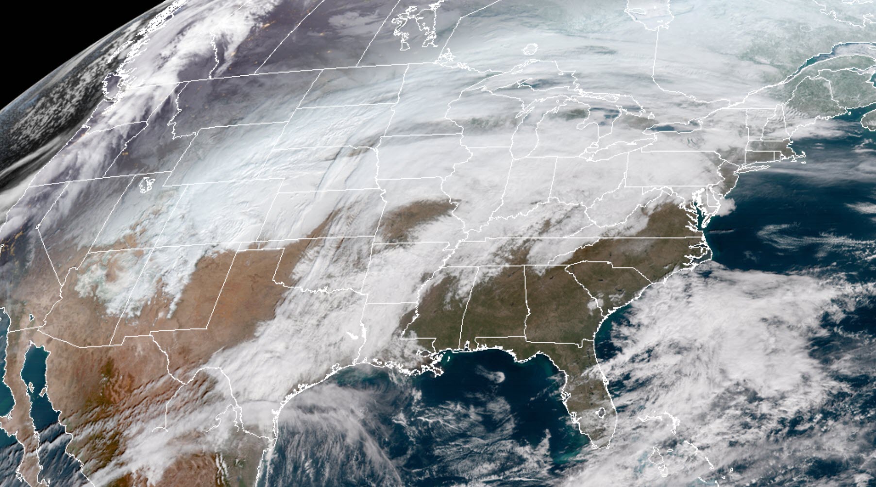
Our rain maker is developing and will move into our region tonight (Sunday night/Monday morning).
You can see it here on the GOES 16 satellite image. Moisture is being pulled in from the Pacific Ocean and the Gulf of Mexico. Typical for this time of the year.
.
.
I made some small adjustments in the going forecast.
I adjusted high temperatures on Tuesday. Lowering them a bit. I also mentioned snow flurries are a possibility at the end of this system. It does not appear to be anything to worry about. That would mainly be Monday night and Tuesday. Again, not concerned about accumulation (if they occur at all).
I also slightly increased wind speeds on Monday.
The main rain band will enter southeast Missouri between 12 am and 3 am. There will be showers ahead of the main line. The main rain shield should be a solid band of precipitation.
Gusty winds are likely on Monday into Monday night. Wind gusts above 35 mph will likely occur (esp on Monday during the day).
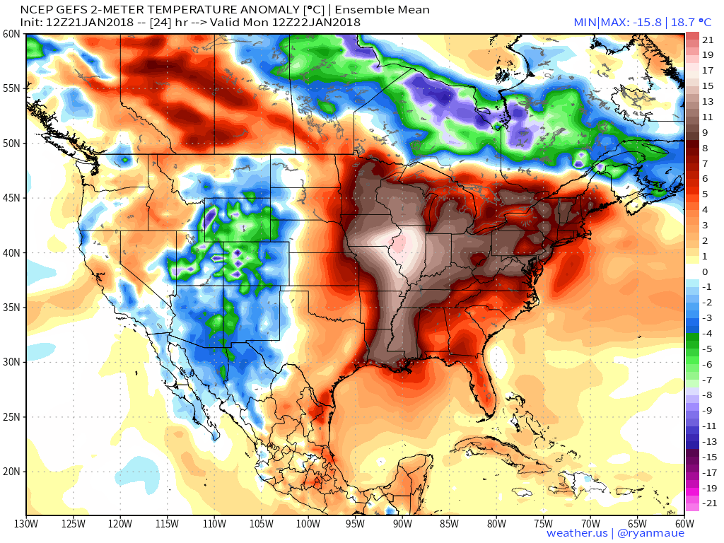
Temperatures will be well above normal today through Monday morning. Warm air pulling northward ahead of our cold front.
Temperature may remain in the 50’s for overnight lows (tonight/Monday morning). Upper 40’s to middle 50’s.
You can see how much above normal temperatures will be on this map. Temperature anomaly map.
.
.
.
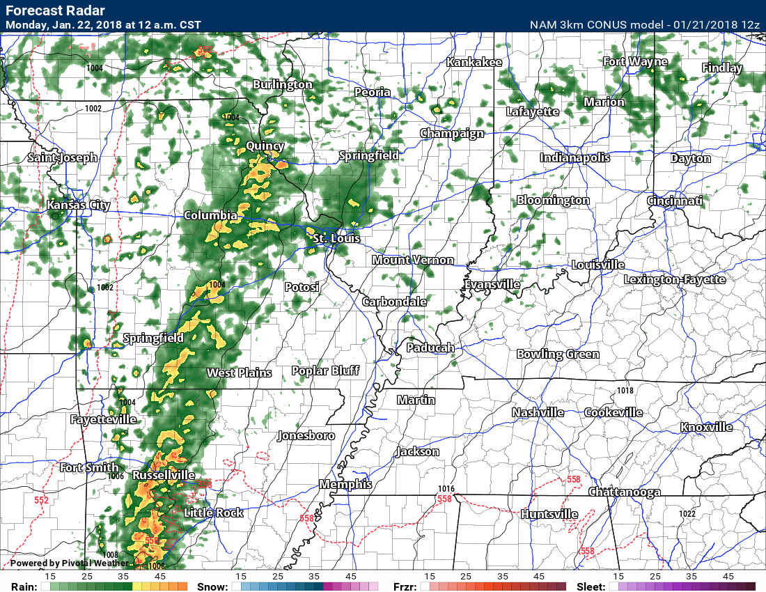
Here is the NAM model guidance future-cast radar for 12 AM Monday.
.
.
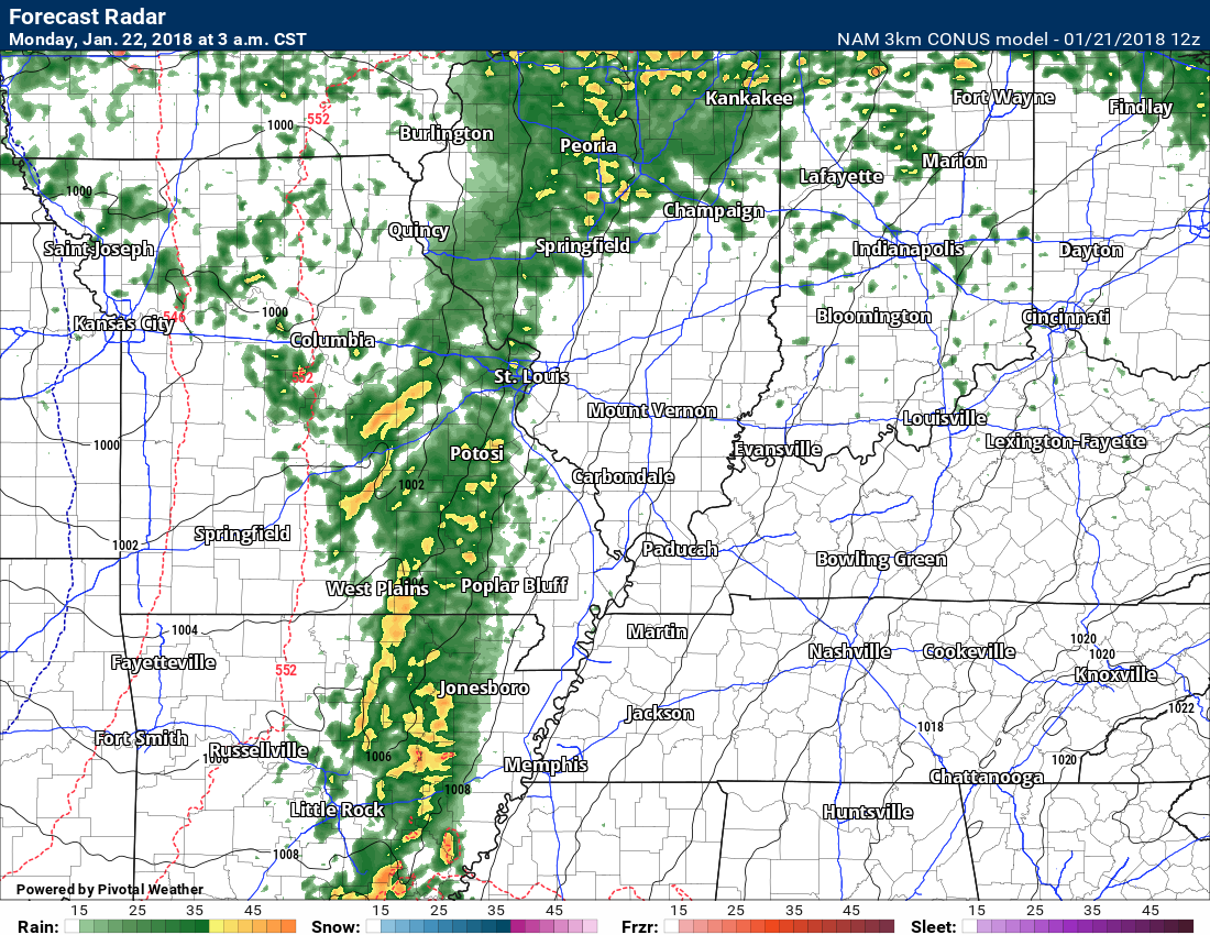
This next image is 3 AM Monday
.
.
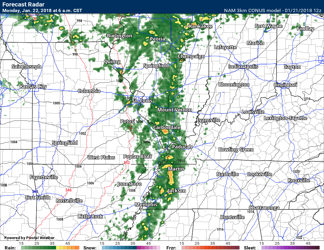
This next image is 6 AM Monday
.
.
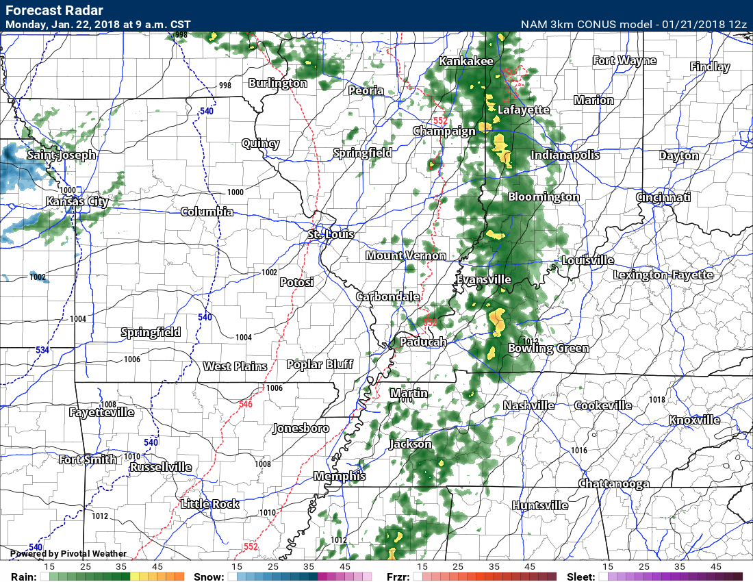
This next image is 9 AM Monday
.
.
You can see the bulk of the rain comes through all at once.
We could have some wrap around showers or flurries Monday afternoon into Tuesday morning. Nothing of significance.
We should remain dry Tuesday night into Friday afternoon.
Another rain maker is possible Friday night into the weekend. That event should be similar our current one.
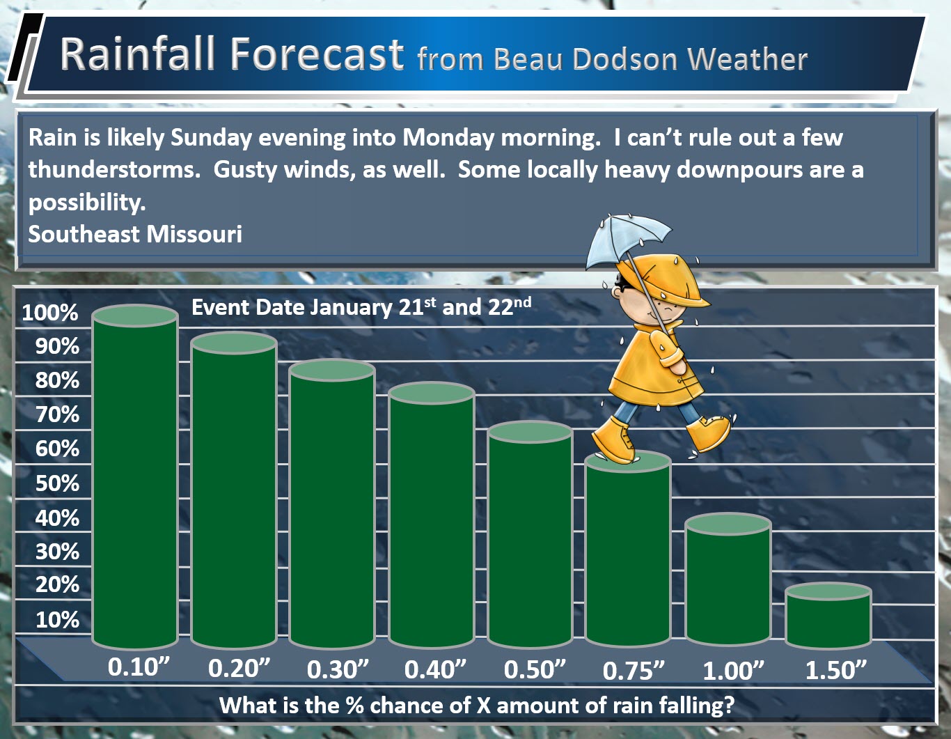
Here are my rainfall total forecasts. What is the % chance of X amount of rain falling.
Southeast Missouri
Totals across southeast Missouri may end up a bit heavier than the rest of the area.
.
.
.
Southern Illinois, western Kentucky, and northwest Tennessee
.

.
With the recent heavy snow pack we could have some water issues in a few locations. Let’s keep an eye on it. This does not appear to be a large flash flood event. Just some pockets of problems could occur.
The snow will likely have melted by the time the line of showers and thunderstorms arrive.
.


We offer regional radars and local city radars – if a radar does not update then try another one. Occasional browsers need their cache cleared. You may also try restarting your browser. This will usually fix any problems.
During the winter you can track snow and ice by clicking the winterize button on the local city view interactive radars.
You may email me at beaudodson@usawx.com
Interactive Weather Radar Page. Choose the city nearest your location: Click this link
National interactive radar: Click this link.