January 19, 2018

.
Weather Talk subscribers you can view today’s long range and videos on the www.weathertalk.com website under the Winter Weather Outlook tab. If you are not a subscriber, then you can subscribe at www.beaudodsonweather.com
January 19, 2018
Friday Night Forecast Details:
Forecast: Mostly clear early. Increasing clouds overnight. Patchy fog possible.
Temperatures: MO ~ 28 to 34 IL ~ 28 to 32 KY ~ 28 to 32
What is the chance of precipitation? MO ~ 5% IL ~ 5% KY ~ 5% TN ~ 5%
Coverage of precipitation: Most likely none.
Wind chill values: 30 to 35
Accumulating snow or ice: Unlikely
Winds: South and southwest at 7 to 14 mph and gusty
What impacts are anticipated from the weather? Patchy fog, otherwise no impacts.
My confidence in the forecast verifying: High
Is severe weather expected? No
The NWS defines severe weather as 58 mph wind or great, 1″ hail or larger, and/or tornadoes
Should I cancel my outdoor plans: No
.
January 20, 2018
Saturday Forecast Details
Forecast: Fog possible. Cloudy. Patchy drizzle possible. Warmer.
Temperatures: MO ~ 45 to 50 IL ~ 44 top 48 over the snow pack. 46 to 52 outside the snow pack area. KY ~ 44 to 48 over the snow pack area.
What is the chance of precipitation? MO ~ 20% IL ~ 20% KY ~ 20% TN ~ 20%
Coverage of precipitation: Patchy drizzle possible
Wind chill values: N/A
Accumulating snow or ice: No
Winds: South and southwest at 6 to 12 mph with gusts to 20 mph
What impacts are anticipated from the weather? Perhaps wet roadways. Lower visibility in fog.
My confidence in the forecast verifying: High
Is severe weather expected? No
The NWS defines severe weather as 58 mph wind or great, 1″ hail or larger, and/or tornadoes
Should I cancel my outdoor plans? No, but check radar and fog conditions.
.
Saturday Night Forecast Details:
Forecast: Cloudy. Fog possible. Patchy drizzle.
Temperatures: MO ~ 38 to 44 IL ~ 38 to 44 KY ~ 38 to 44
What is the chance of precipitation? MO ~ 20% IL ~ 20% KY ~ 20% TN ~ 20%
Coverage of precipitation: Isolated or patchy
Wind chill values: 40 to 45
Accumulating snow or ice: No
Winds: South and southwest at 7 to 14 mph with gusts to 20 mph
What impacts are anticipated from the weather? Wet roadways. Patchy fog.
My confidence in the forecast verifying: Medium
Is severe weather expected? No
The NWS defines severe weather as 58 mph wind or great, 1″ hail or larger, and/or tornadoes
Should I cancel my outdoor plans: Have a plan B
.
January 21, 2018
Sunday Forecast Details
Forecast: Cloudy. Patchy fog. A few spotty showers are possible. Cool.
Temperatures: MO ~ 52 to 58 IL ~ 52 to 56 KY ~ 52 to 56
What is the chance of precipitation? MO ~ 20% IL ~ 20% KY ~ 20% TN ~ 20%
Coverage of precipitation: Isolated
Wind chill values: N/A
Accumulating snow or ice: No
Winds: South at 8 to 16 mph and gusty
What impacts are anticipated from the weather? Wet roadways. If fog develops, then lower visibility possible
My confidence in the forecast verifying: Medium
Is severe weather expected? No
The NWS defines severe weather as 58 mph wind or great, 1″ hail or larger, and/or tornadoes
Should I cancel my outdoor plans? No, but check radars.
.
Sunday Night Forecast Details:
Forecast: Cloudy. Temperatures holding steady. Increasing rain chances overnight. A thunderstorm possible, especially over the southern half of the region (Bootheel into west KY/TN). Gusty winds.
Temperatures: MO ~ 45 to 50 IL ~ 45 to 50 KY ~ 45 to 50
What is the chance of precipitation? MO ~ 100% (mostly late) IL ~ 90% (mostly late) KY ~ 90% (mostly late) TN ~ 100% (mostly late)
Coverage of precipitation: Becoming widespread.
Wind chill values: 36 to 44
Accumulating snow or ice: No
Winds: South wind at 10 to 20 mph with gusts to 35 mph. Winds becoming southwest.
What impacts are anticipated from the weather? Wet roadways. Lightning possible.
My confidence in the forecast verifying: High
Is severe weather expected? Most likely no, but monitor updated forecasts.
The NWS defines severe weather as 58 mph wind or great, 1″ hail or larger, and/or tornadoes
Should I cancel my outdoor plans: Have a plan B
.
January 22, 2018
Monday Forecast Details
Forecast: Mostly cloudy the first half of the day and then some clearing possible. Breezy. Showers possible before 2 PM. Rain should be ending west to east.
Temperatures: MO ~ 50 to 55 IL ~ 50 to 55 KY ~ 48 to 54
What is the chance of precipitation? MO ~ 40% before 10 am IL ~ 50% before 10 am KY ~ 60% first half of the day TN ~ 60% first part of the day
Coverage of precipitation: Scattered to perhaps widespread early in the morning. Ending west to east.
Wind chill values: N/A
Accumulating snow or ice: No
Winds: Winds becoming west and southwest at 14 to 25 mph and gusty.
What impacts are anticipated from the weather? Perhaps wet roadways. Perhaps lightning early in the morning.
My confidence in the forecast verifying: High
Is severe weather expected? Unlikely
The NWS defines severe weather as 58 mph wind or great, 1″ hail or larger, and/or tornadoes
Should I cancel my outdoor plans? No
.
Monday Night Forecast Details:
Forecast: Clearing. Patchy fog possible.
Temperatures: MO ~ 30 to 35 IL ~ 30 to 35 KY ~ 30 to 35
What is the chance of precipitation? MO ~ 0% IL ~ 0% KY ~ 5% TN ~ 5%
Coverage of precipitation: None
Wind chill values: 25 to 32
Accumulating snow or ice: No
Winds: West and southwest at 8 to 16 mph and gusty
What impacts are anticipated from the weather? None.
My confidence in the forecast verifying: High
Is severe weather expected? No
The NWS defines severe weather as 58 mph wind or great, 1″ hail or larger, and/or tornadoes
Should I cancel my outdoor plans: No
.
January 23, 2018
Tuesday Forecast Details
Forecast: Mostly sunny.
Temperatures: MO ~ 44 to 48 IL ~ 44 to 48 KY ~ 44 to 48
What is the chance of precipitation? MO ~ 0% IL ~ 0% KY ~ 0% TN ~ 0%
Coverage of precipitation: None
Wind chill values: N/A
Accumulating snow or ice: No
Winds: West wind 7 to 14 mph
What impacts are anticipated from the weather? None
My confidence in the forecast verifying: Medium
Is severe weather expected? No
The NWS defines severe weather as 58 mph wind or great, 1″ hail or larger, and/or tornadoes
Should I cancel my outdoor plans? No
.
Tuesday Night Forecast Details:
Forecast: A few clouds, otherwise mostly clear. Patchy fog possible.
Temperatures: MO ~ 26 to 32 IL ~ 26 to 32 KY ~ 26 to 32
What is the chance of precipitation? MO ~ 0% IL ~ 0% KY ~ 0% TN ~ 0%
Coverage of precipitation: Most likely none
Wind chill values: 25 to 35
Accumulating snow or ice: No
Winds: West at 7 to 14 mph
What impacts are anticipated from the weather? Lower visibility if fog forms.
My confidence in the forecast verifying: Medium
Is severe weather expected? No
The NWS defines severe weather as 58 mph wind or great, 1″ hail or larger, and/or tornadoes
Should I cancel my outdoor plans: No
.
January 24, 2018
Wednesday Forecast Details
Forecast: Mostly sunny morning. Perhaps some afternoon clouds.
Temperatures: MO ~ 45 to 50 IL ~ 45 to 50 KY ~ 45 to 50
What is the chance of precipitation? MO ~ 0% IL ~ 0% KY ~ 0% TN ~ 0%
Coverage of precipitation: Most likely none
Wind chill values: N/A
Accumulating snow or ice: N0
Winds: Variable winds at 5 to 10 mph
What impacts are anticipated from the weather? None
My confidence in the forecast verifying: Medium
Is severe weather expected? No
The NWS defines severe weather as 58 mph wind or great, 1″ hail or larger, and/or tornadoes
Should I cancel my outdoor plans? No
.
Wednesday Night Forecast Details:
Forecast: Partly cloudy.
Temperatures: MO ~ 30 to 35 IL ~ 30 to 35 KY ~ 30 to 35
What is the chance of precipitation? MO ~ 10% IL ~ 10% KY ~ 10% TN ~ 10%
Coverage of precipitation: Most likely none
Wind chill values: N/A
Accumulating snow or ice: No
Winds: Southeast winds at 5 to 10 mph
What impacts are anticipated from the weather?
My confidence in the forecast verifying: LOW
Is severe weather expected? No
The NWS defines severe weather as 58 mph wind or great, 1″ hail or larger, and/or tornadoes
Should I cancel my outdoor plans: Monitor updates
.
January 25, 2018
Thursday Forecast Details
Forecast: Partly cloudy. A shower possible.
Temperatures: MO ~ 45 to 50 IL ~ 45 to 50 KY ~ 45 to 50
What is the chance of precipitation? MO ~ 20% IL ~ 20% KY ~ 20% TN ~ 20%
Coverage of precipitation:
Wind chill values: N/A
Accumulating snow or ice: No
Winds: South and southwest at 7 to 14 mph
What impacts are anticipated from the weather?
My confidence in the forecast verifying: LOW
Is severe weather expected? No
The NWS defines severe weather as 58 mph wind or great, 1″ hail or larger, and/or tornadoes
Should I cancel my outdoor plans? Monitor updates
.
Thursday Night Forecast Details:
Forecast: Mostly cloudy. A chance of showers.
Temperatures: MO ~ 35 to 40 IL ~ 35 to 40 KY ~ 35 to 40
What is the chance of precipitation? MO ~ 20% IL ~ 20% KY ~ 20% TN ~ 20%
Coverage of precipitation:
Wind chill values:
Accumulating snow or ice: No
Winds: Southwest and west at 6 to 12 mph
What impacts are anticipated from the weather?
My confidence in the forecast verifying: LOW
Is severe weather expected? No
The NWS defines severe weather as 58 mph wind or great, 1″ hail or larger, and/or tornadoes
Should I cancel my outdoor plans: Monitor updates
.

.
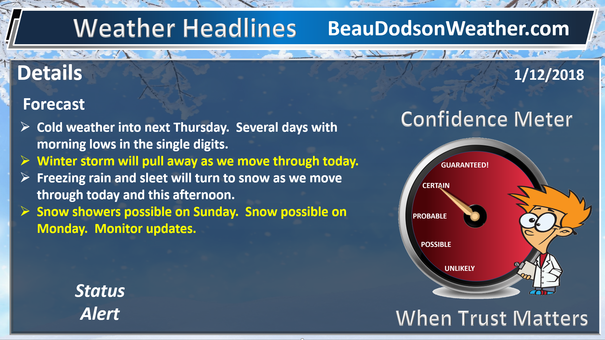
Tonight through next Tuesday: Winter precipitation is not anticipated.
.

.
The National Weather Service definition of a severe thunderstorm is one that produces quarter size hail or larger, 58 mph winds or greater, and/or a tornado.
Sunday and Sunday night: Thunderstorms will be possible. Lightning would be the main concern. Perhaps some gusty winds. Severe weather is not anticipated.
.

.
The daily outlook can be found at the bottom of this post.
Forecast
Interactive Weather Radar Page. Choose the city nearest your location: Click this link.
Short term outlook through Saturday night:
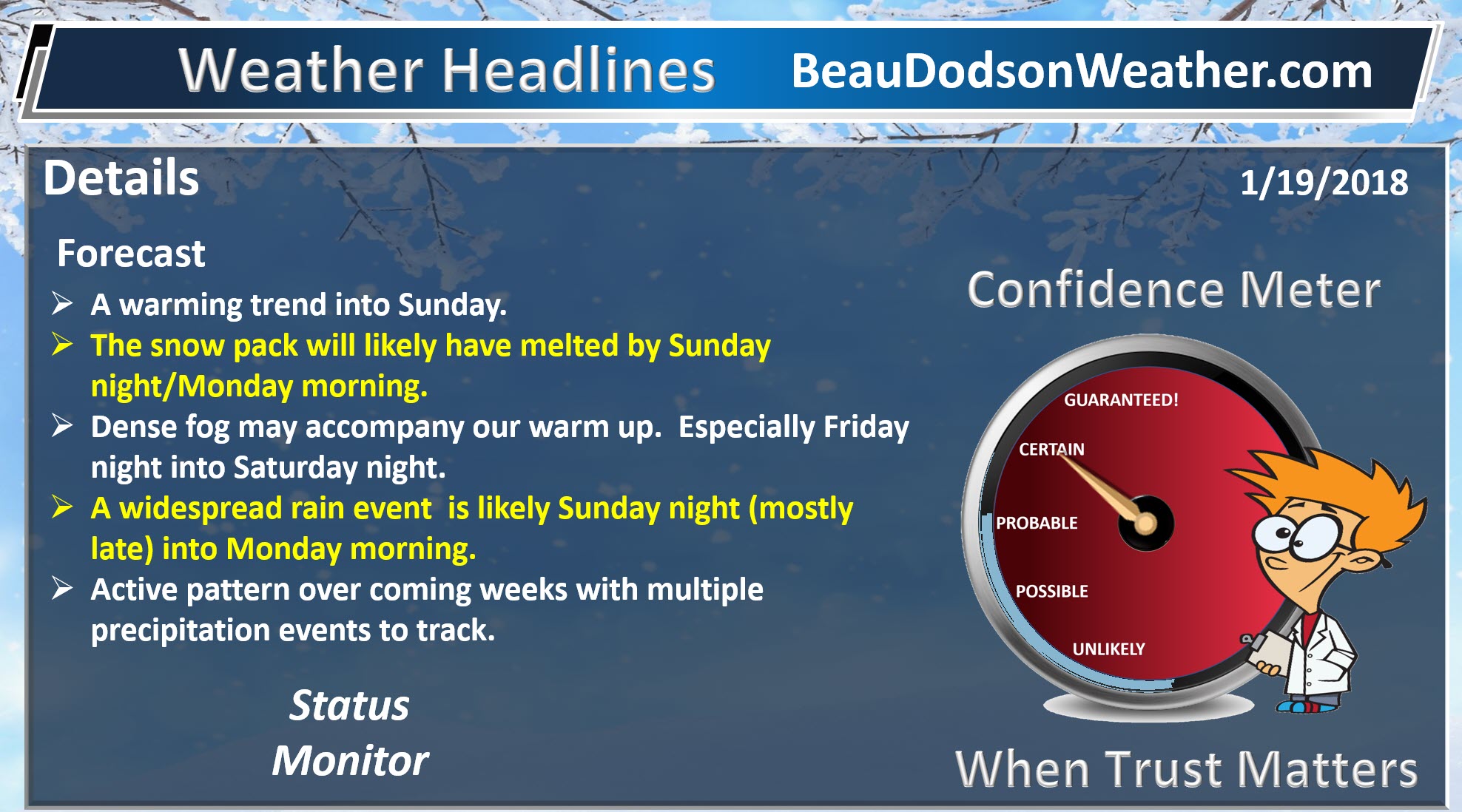
The big weather story continues to be the warming temperatures that will dramatically improve road conditions. Many side roads remain icy and hazardous.
As a matter of fact, by Sunday night and Monday it appears our snow pack will be but a memory.
Temperatures today will rise into the 35 to 42 degree range. Cooler over the snow pack vs elsewhere. We should have plenty of sunshine. That will help melt the ice.
Tonight will be clear the first half of the night with increasing clouds overnight. Patchy fog is also possible. Temperatures won’t be quite as cold. Lows mostly in the 28 to 34 degree range.
Saturday will deliver more clouds, perhaps patchy drizzle, and some fog. It will be milder with temperatures climbing into the middle 40’s across the area. The cold ground and snow may help produce fog. This will need to be monitored.
Saturday night will deliver mostly cloudy sky conditions. Fog is again possible and perhaps patchy drizzle, as well. For the first night in awhile we will actually have temperatures remaining above freezing through the night. Again, this could help produce fog.
A cold front will be situated well to our west on Saturday.
This map is for Saturday 7 PM. The green represents some patchy drizzle of showers.
You can see the area of low pressure in Colorado. That will track northeast Saturday night into Monday.
.

.
Sunday will be even warmer ahead of a cold front. Temperatures should climb into the 50’s! Gusty winds will develop, as well.
Check out these temperature maps for Sunday afternoon into Sunday night.
Notice how temperatures spike immediately ahead of the cold front. Warmer air being pulled northward with the area of low pressure to our north. Remember, low pressure rotates counter-clockwise. That means our winds will be from the south as the low is well north of us.
Low pressure to our north places us in the warm sector of the system. Warm sector meaning the warmer air and rain.
The exact timing of the warmer air may vary a bit. I am still fine tuning the timing of frontal passage. Either way, you get the general idea. Milder ahead of the cold front.
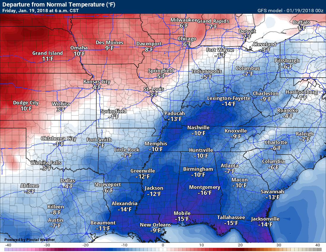
Let me show you the temperature anomaly map. How many degrees above or below normal will we be?
Normal high temperatures are around 43 degrees and normal low temperatures are around 26 degrees.
This first map is for 6 AM Friday. Well below normal.
.
.
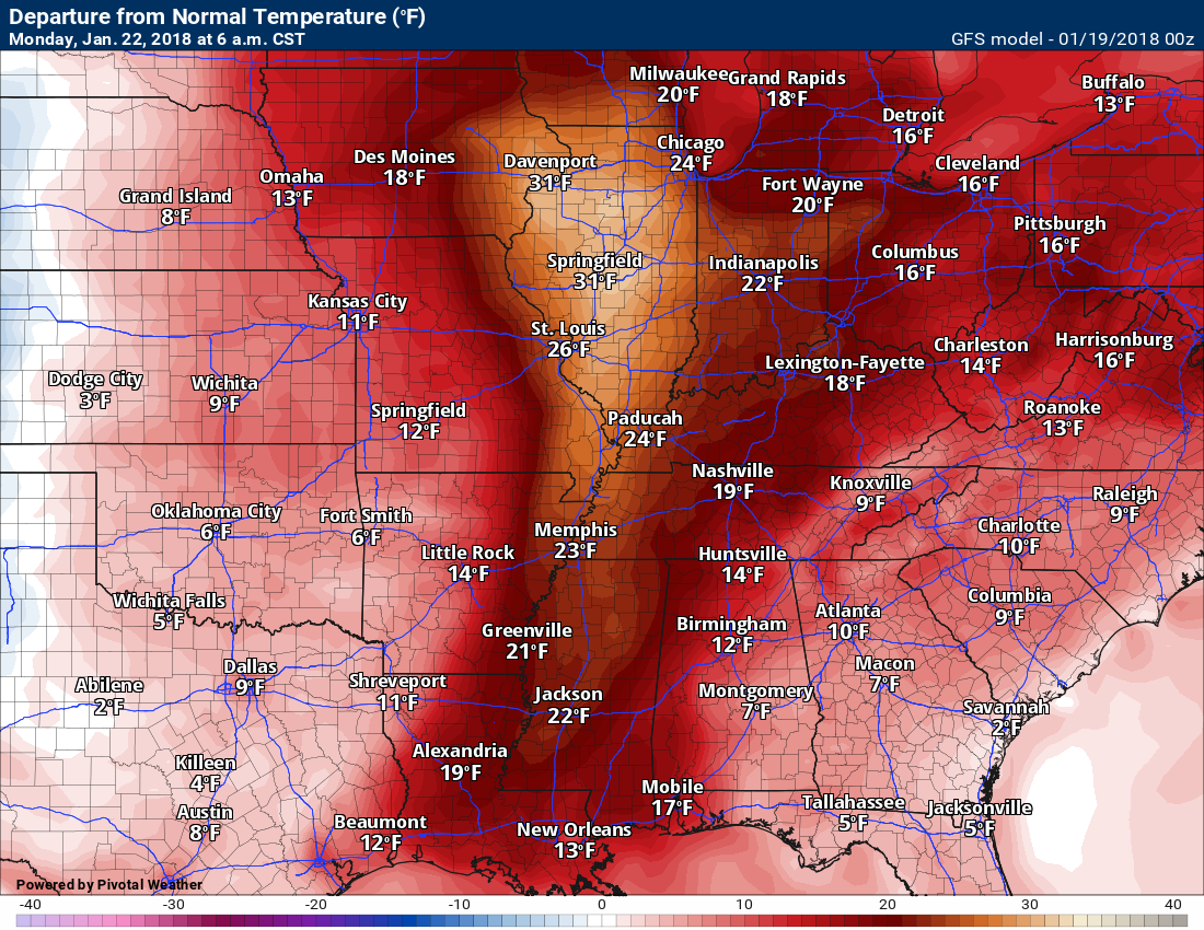
Look what happens ahead of the cold front. Much above normal temperatures.
.
.
Sunday 6 PM temperatures
Notice that warmer air to our west ahead of the cold front.
.

Monday 6 AM
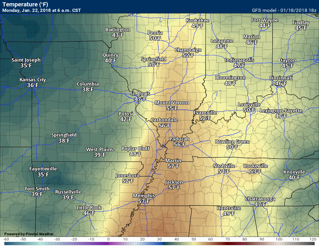
Monday 12 PM (this will really depend on the timing of the cold front).

.
The cold front will push into the region Sunday night and Monday morning. The best chance of rain will be late Sunday night into the early morning hours of Monday. I can’t rule out a thunderstorm.
Rain will be most likely near the front. With that said, some patchy drizzle or showers are possible as early as Saturday as the warm air advects into our local area.
Typically, this would be a severe weather setup. Just not sure we have enough instability for severe thunderstorms. For now, I will continue to monitor the risk.
Gusty winds will be possible Sunday night and Monday morning. Winds should gust above 30 mph.
Rain ends from west to east Monday afternoon. Temperatures behind the front will be somewhat cooler, but not like recent arctic fronts.
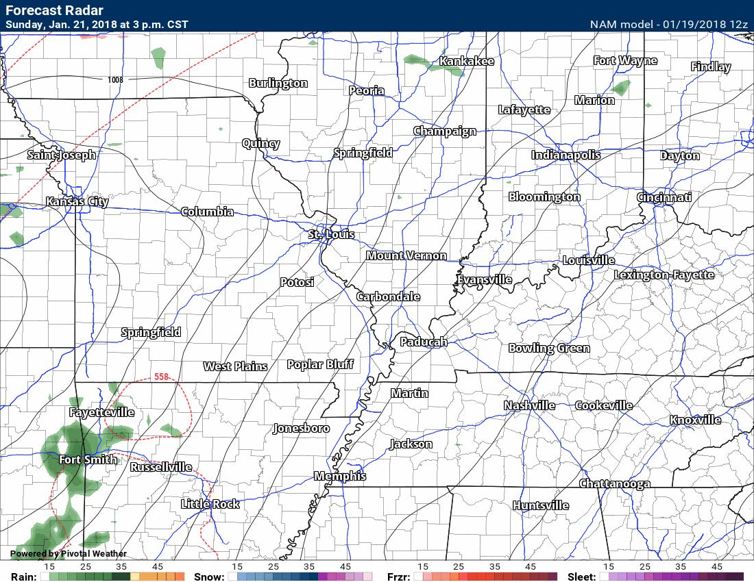
Here is the latest NAM model guidance future-cast radar. Most of the rain arrives Sunday night and Monday morning. Drizzle or light showers are possible Saturday into Sunday.
This is what radar might look like. The timing could be off a bit. It is just a model.
.
.
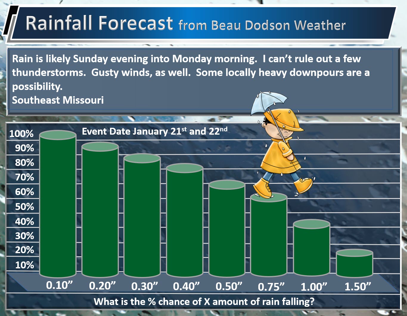
Rainfall totals of 0.30″ to 0.60″ are anticipated. Locally higher totals are likely. This is especially true if thunderstorms form and across southeast Missouri.
Here are my rainfall probability numbers. What is the % chance of X amount of rain falling.
Southeast Missouri
Totals across southeast Missouri may end up a bit heavier than the rest of the area.
.
.
Southern Illinois, western Kentucky, and northwest Tennessee
.

.
With the recent heavy snow pack we could have some water issues in a few locations. Let’s keep an eye on it. This does not appear to be a large flash flood event. Just some pockets of problems could occur.
The snow will likely have melted by the time the line of showers and thunderstorms arrive.
I am watching one or two systems for the middle and end of next week. Right now projections are for rain. It is a bit early for certainties. Monitor updates.
Beau’s Winter Weather Outlook
.
.
I am watching a system towards the middle and end of next week. For now, it looks like rain. I would note that some data sets are colder. I will monitor.
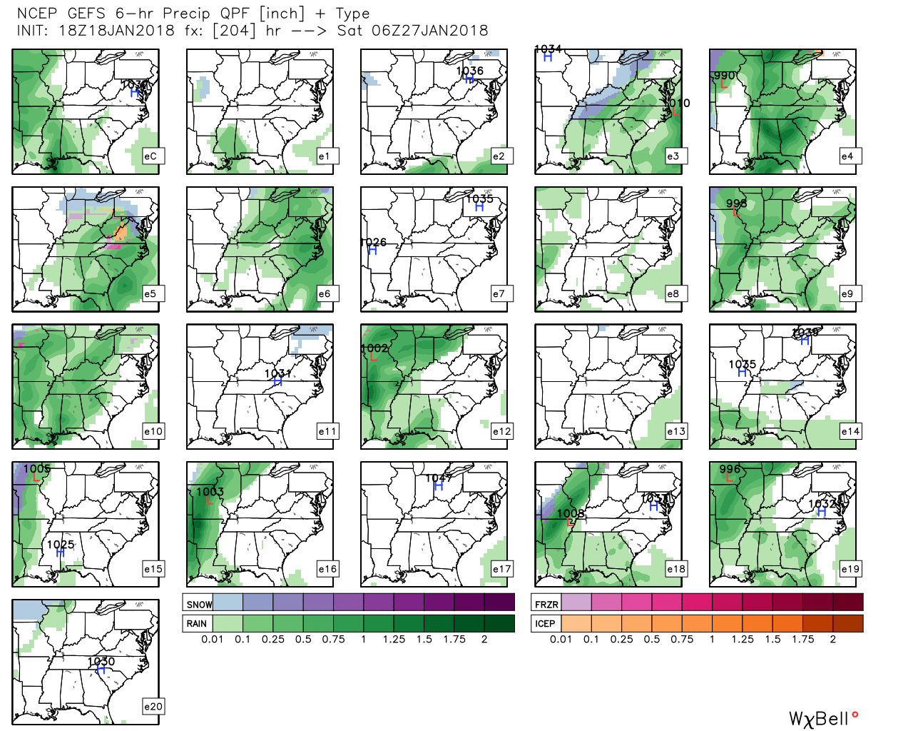
The GFS ensembles mostly show rain.
.
What are ensembles?
.
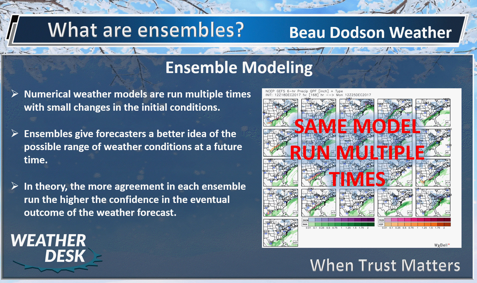
.
Each of these squares is one run of the GFS ensemble.
.
.


We offer regional radars and local city radars – if a radar does not update then try another one. Occasional browsers need their cache cleared. You may also try restarting your browser. This will usually fix any problems.
During the winter you can track snow and ice by clicking the winterize button on the local city view interactive radars.
You may email me at beaudodson@usawx.com
Interactive Weather Radar Page. Choose the city nearest your location: Click this link
National interactive radar: Click this link.