We have our first sponsor for the blog. Milner and Orr Funeral Home and Cremation Services located in Paducah, Kentucky and three other western Kentucky towns – at Milner and Orr they believe in families helping families.
![]()

This forecast update covers far southern Illinois, far southeast Missouri, and far western Kentucky. See the coverage map on the right side of the blog. Remember that weather evolves. Check back frequently for updates.
Saturday – A mix of sun and clouds. Windy. Milder. Winds will make it feel a bit cooler. High temperatures well into the 50’s South/southwest winds at 10-25 mph with gusts above 30 mph in the afternoon.
Saturday night – Increasing clouds as a cold front approaches. Light shower possible. Low temperatures in the 30’s. Winds becoming west/northwest at 10-15 mph.
Sunday – Partly cloudy and mild. Not bad for January. High temperatures will be in the 50’s. West winds becoming southwest at 5-10 mph.
Sunday night – Mostly clear. Cool. Not bad for January. Low temperatures in the 30’s. Southwest winds at 5-10 mph.
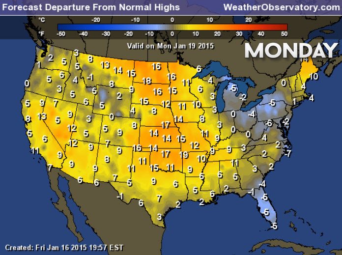
Monday – Martin Luther King Day – Partly sunny and mild. High temperatures should be well into the 50’s. Southwest winds during the morning becoming southerly in the afternoon. Wind speeds of 5-10 mph.

Current Temperatures Around The Local Area


An explanation of what is happening in the atmosphere over the coming days…
A calm weather day is on tap for the region. Is this our long awaited January thaw? Appears it might have to be. Although it will likely be a short thaw. Appears we may see 50’s for the next few days!

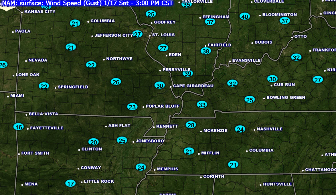
You will have to deal with gusty winds today (warmer air arriving in the winter = gusty winds). This will make it feel a bit cooler, unfortunately. Winds will gust in the 20-35 mph range from time to time today.
Here are the wind gusts that are being forecast by the NAM model.
This is an unusual weather pattern across the United States. Very calm. It has been this way for most of the Month of January. The lack of winter storms has been amazing. Much of the nation could use some precipitation. It is not very often you will see a January this calm.
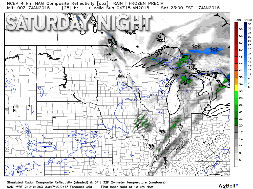
A weak cold front arrives tonight and will move through the region on Sunday morning. Clouds and perhaps a light sprinkle or shower will accompany the front. Winds will also shift out of the west/northwest briefly then turn back around to the southwest by Sunday afternoon or night.
Future-cast radar does show some very light drizzle, light rain, light showers along the front. This is for late Saturday night. Little drizzle symbol there and the rain shower symbol in Indiana. weatherbell.com image
Temperatures on Sunday should be a little cooler than today. But, this is not a sharp cold front and will not usher in another blast of cold air. Just slightly cooler air.
Temperatures on Monday, Martin Luther King Day, won’t be too bad for the Month of January. The January thaw will continue! Highs will be in the 50’s.
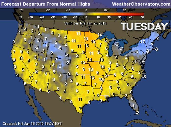
A second cold front arrives on Tuesday. Moisture is limited with this front, as well. Maybe some light showers or showers. But, nothing significant is anticipated. Listen to the calm….
No significant rain is in the short range forecast (or snow for that matter).
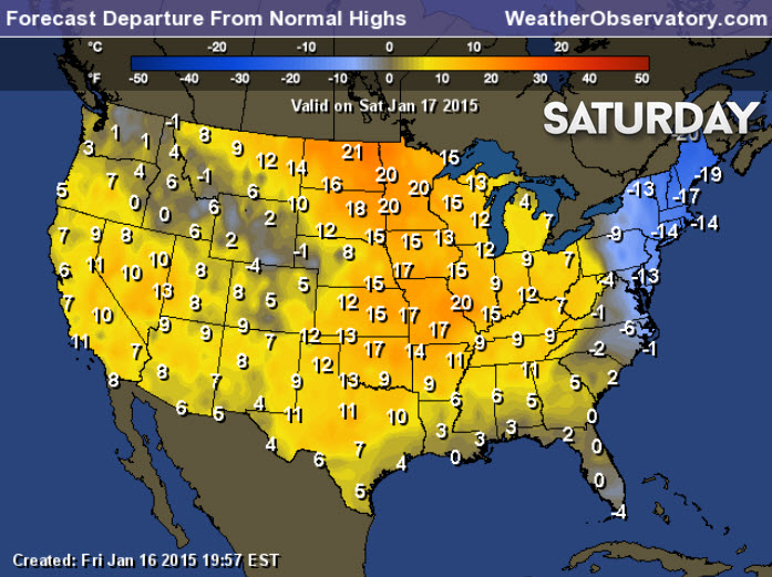
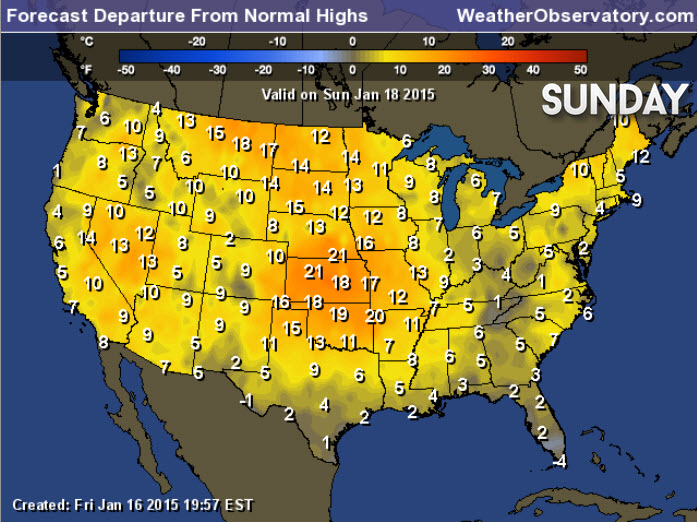
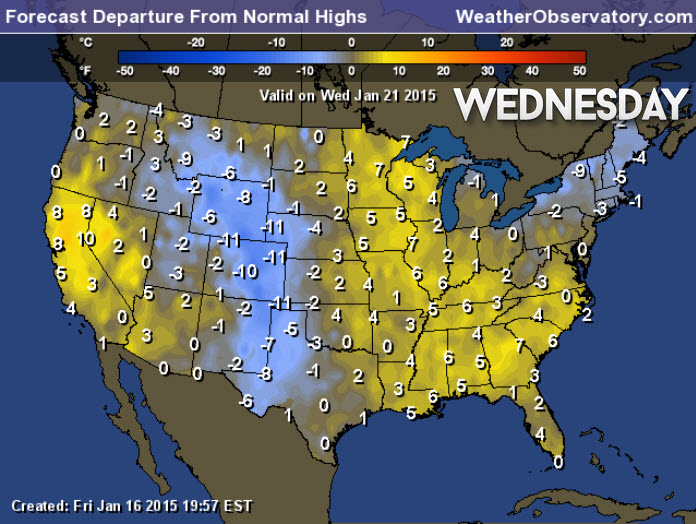
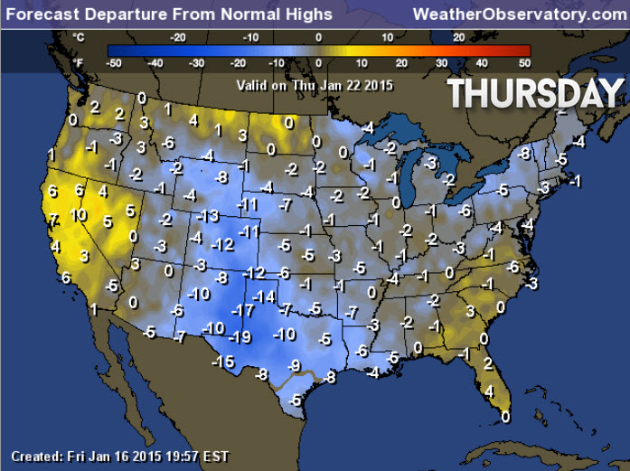
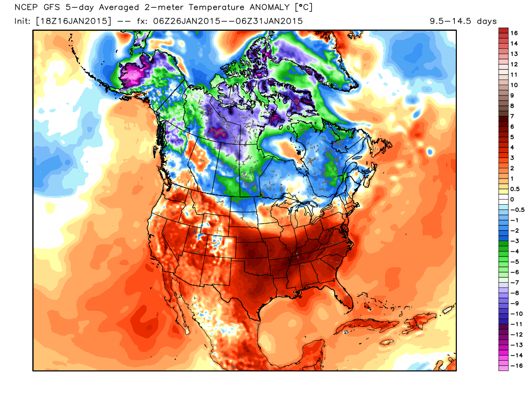
Let’s walk you through the coming days and the temperature anomalies. These maps show you how many degrees above or below normal temperatures will be over the coming days (high temperatures). I will step you through the week. Note towards the end of the period that temperatures start to cool down.
Normal highs for this time of the year are 41 degrees
Normal lows for this time of the year are 26 degrees
Check out the extended discussion concerning the next potential cold blast.
Did you know that the Weather Observatory is funded by people like you? I rely on ad’s on this blog and individual donations. PayPal also allows you to set up a monthly donation. I have had several people give $5, $10, and $20 a month. A recurring donation helps keep the weather information flowing. If you enjoy this blog, the Twitter account, the Facebook interaction, the weather radars, and all of the other information then consider making a donation or setting up a recurring donation (if you don’t use PayPal then contact me through email about how you can mail your donation) beaudodson@usawx.com Thank you!

No major changes.

No major concerns in this forecast!
Gusty winds today – gusts may exceed 30 mph from time to time.
Check out our newest sponsors $5 meal! The DQ Grill and Chill (located across from Noble Park in Paducah, Kentucky) is the newest WeatherTalk Blog sponsor! A local business helping to sponsor the weather information that you have come to love so much.
They also have a Facebook Page and I encourage you to check it out. DQ Grill and Chill on Facebook


The wild card tells you where the uncertainties are in the forecast
Wild card in this forecast – The wild card will be high temperatures today and tomorrow. How much into the 50’s will temperature rise 🙂

Can we expect severe thunderstorms over the next 24 to 48 hours? Remember that a severe thunderstorm is defined as a thunderstorm that produces 58 mph winds or higher, quarter size hail or larger, and/or a tornado.
Thunderstorm threat level is ZERO


Will I need to take action?
No significant weather anticipated. Gusty winds today.

How much precipitation should we expect over the next few days?
No significant rainfall through the weekend. Small chance for a light rain shower with a front on Saturday night/Sunday morning.
We have a new sponsor! G&C Multi-Services out of Paducah, Kentucky. G & C Multi-Services is a service provider in Western Kentucky that provides industrial and commercial equipment fabrication, machine troubleshooting, repair and maintenance, and installation. They can custom fabricate steel, stainless, and aluminum products per customer specifications.
Visit their web-site here. Or click the ad below! They have a Facebook page and it can be viewed here.


Not able to find any winter weather over the coming days. Our much anticipated January semi-thaw is underway. It isn’t going to be warm by any means. But, at least it will be above freezing.

This section of the blog is speculative forecast information. Because it is past the range of what meteorologists can forecast accurately, it should be considered speculation. Anything past day 5 is considered a long range forecast.
The big deal in the long range might be the next arctic blast of cold air. A lot of the data is showing this occurring towards the end of next week into the following week.
We also have a few weather disturbances to monitor. Remember I have been tracking one system towards the middle/end of next week. The models continue to take this system pretty far south. So far south that it has little impact on our regions weather. I will continue to monitor.
Some of the long range data (quite a bit of it) shows a cold blast turns the end of next week into the following. The GFS model, however, is showing that the January thaw is going to continue for awhile.
Guess we will wait and see what the trends are over the coming days.
GFS temperature anomalies for January 26th through January 31st. WELL above normal in our region. I suspect, based on teleconnections, that this is incorrect. More data lends itself to it becoming cold again than staying mild. Image from www.weatherbell.com

There are a lot of challenges when forecasting winter storms in our region. Typically we are on the rain/snow line. That means that some of our counties will receive snow. Some of our counties will receive sleet. Some of our counties will receive freezing rain. And, some of our counties will end up rain! Trying to figure out what counties will receive what precipitation is usually problematic.
I want to encourage you to check back frequently for forecast updates leading up to and during a winter storm. The forecast will change. Rarely does a forecast 24-48 hours in advance of the winter storm stay the same. The forecast will evolve. One hopes the forecast becomes more accurate as the event draws nearer. But, with that said, it is not unusual for the forecast to be updated while a storm is underway.
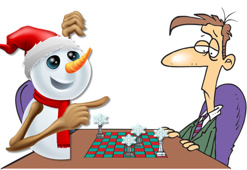
Think of a winter storm as a game of chess. The storm moves…forecasters reevaluate and then make a forecast. The storm makes its next move. Forecasters reevaluate and update the forecast. With each move of the winter storm it becomes more and more clear what direction the forecast should move towards. A great forecaster will stay one step ahead of the winter storm. But, there are always surprises. Checkmate? Sometimes.
Most winter storm will over-perform in a few counties. Most winter storms will under-perform in a few counties. During a rainstorm not everybody ends up with the exact same amount of precipitation. The same applies to winter storms. Nobody cares if they receive 0.30″ vs 0.60″ of rain during the summer months. Most people would not even realize the difference. But, again – when that ends up being snow you are looking at the difference between a 3″ snowstorm and a 6″ snowstorm!
Doesn’t changing the forecast, during a winter storm, mean the meteorologist has no clue as to what they are doing?
No. This is an expectation misconception. Sometimes the public sets their expectations too high. I would ask that you remember that a forecast is a prediction and not a promise. A forecast is predicting something that is going to happen in the future. Even the best forecaster will update and tweak their forecast once a winter storm is underway (sometimes more than once).
The atmosphere is a fluid. And thus, it is fluid! If a storm shifts 30 or 40 miles then that will change the forecast. Thirty or forty miles, in our large expansive atmosphere, is a grain of sand.
If a snowstorm is forecast for Wednesday and you read the forecast on Monday and then you don’t check later updates…well, you are not going to receive an accurate forecast. You might have a general idea of what to expect, but it likely won’t be very accurate.
Most of you want to know what will happen in your backyard. We call this IMBY (in my backyard). What you should remember is that forecasting snow is not the same as forecasting rain.
During the summer months if I forecast 0.10″ of rain, most of you really don’t care. That is not enough rain to disrupt your ballgame or outdoor events. But, did you know that 0.10″ of rain equals about 1″ of snow? In our region, one inch of snow, on cold roadways, can cause widespread hazardous driving conditions. Unfortunately, these light snow events usually cause widespread problems. People perceive the threat as minimal (it wasn’t an 8″ snowstorm so it must not be that bad). The reality is that the threat can be higher during a minimal snow event than a bigger event. Historically that has been the case in our region.
There is a lot of pressure on forecasters to accurately forecast the impacts of a winter weather event. Normally the forecast will change several times before the storm occurs. Normally the forecast changes while a storm is underway. Forecasting impact is not an exact science.
Impacts can depend on
- Road temperatures
- Time of the event (morning rush hour or afternoon)
- Day of the week (weekend system vs a Monday morning “back to work event”
- Ground/surface temperatures
- Wind speed (blowing snow or drifting snow)
- Time of year. Is this the first winter storm of the season?
- All snow event or did it rain before it snowed? Wintry mix or plain snow?
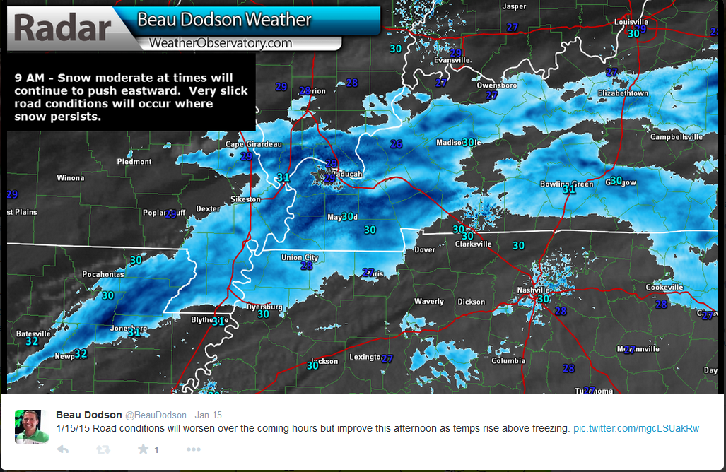
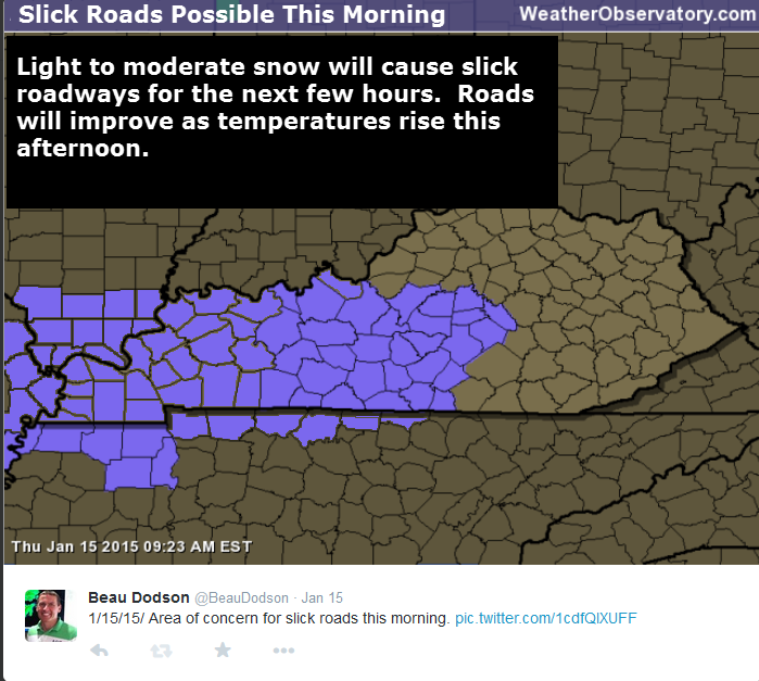
The best advice when following a winter storm forecast is to check back frequently for updates. The winter storm this past Thursday produced a dusting in some of our counties. Many counties ended up with 1/2″-2″ of snow. This caused icy roadways. Forecasters were not sure where the heaviest band would develop until it developed. Some of the high resolution models picked up on the potential for banding as early as late Wednesday night. But, again – the exact placement of banding was questionable.
What is banding? Snow banding is a concentration of falling snow over a three to six hour period in a 20 to 50 mile area. Banding can cause enhanced snowfall totals. Where banding occurs can be extremely difficult to pinpoint even hours in advance…let alone a day in advance.
Banding can mean the difference between a dusting of snow and a few inches of snow. Banding can wreck an otherwise great forecast. Banding is what causes forecasters to bang their heads on the forecast desk.
Mesoscale banding of snowfall is a complicated process that is very difficult to forecast for. It is usually a process that is misunderstood by the general public and can lead to some thinking that meteorologist have no clue what the storm is going to do. The best way to approach the forecasting of such environments is to try to explain the threat and the impact of such processes.
I knew banding would occur on Thursday morning. The question was where would it occur. It ended up occurring over portions of western Kentucky. Where banding occurred there were several reports of 2″ of snow (and some places a bit more).
This was covered in the now-cast thread on my Facebook page and Twitter account. A now-cast is a forecast update as an event unfolds. Again, this is why you should check back for updated forecasts.
Here was a post I made the night before the snow event (Facebook post)
I show you this so that you understand the data flows…continuously. One forecast isn’t going to give you the entire picture. Checking back is the best advice.
Also don’t forget to utilize Twitter. The Paducah, KY National Weather Service has an account…local media meteorologists have accounts. These are two tweets that I sent out during the event.
Click images for larger view
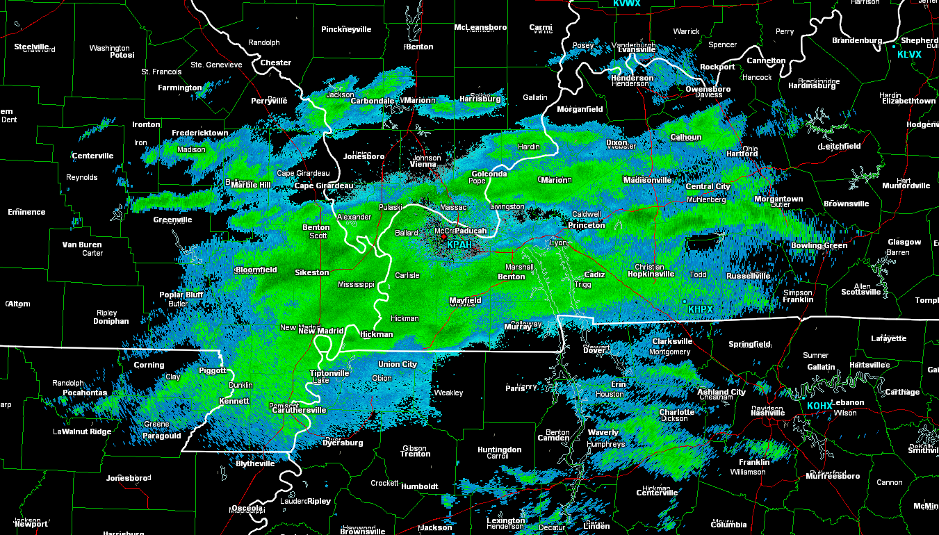
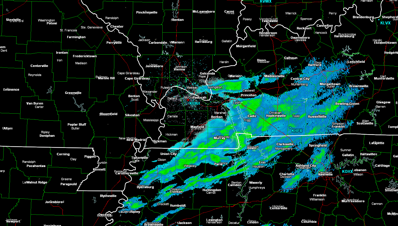
Let’s take a look at radar from this snow event…
I am going to show you were bands of enhanced snowfall occurred.
These images represent a time frame of 3-4 hours.
I circled the area where a heavier snow band formed.
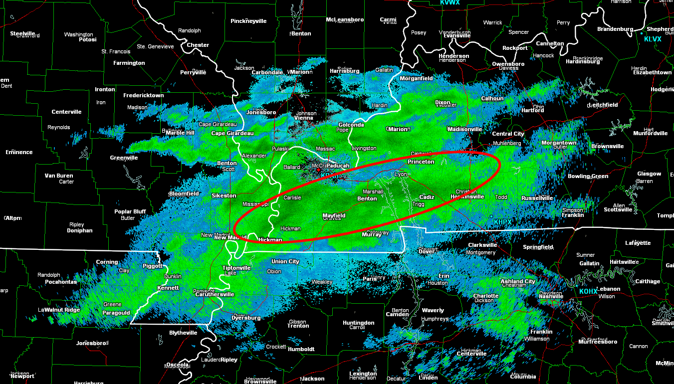
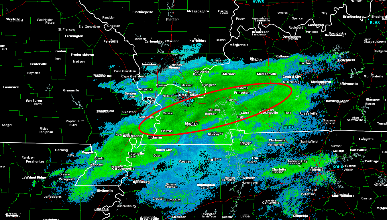
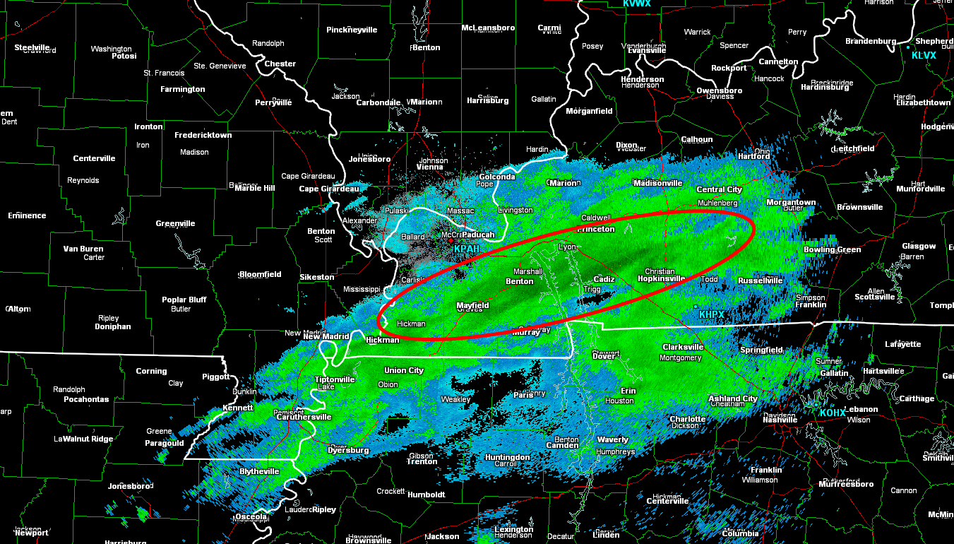
Note this area of moderate snow over parts of the Owensboro, Kentucky area (image below). Numerous wrecks were reported in Daviess County, Kentucky. Some with injuries. At least one fatality was reported.
These small bands of moderate snow made it complicated for the National Weather Service. There were questions as to whether they should issue a winter weather advisory or cover it with a special weather statement. Not an easy decision because the problem areas were spotty. In the end, the problem areas were covered with special weather statements, instead of advisories.
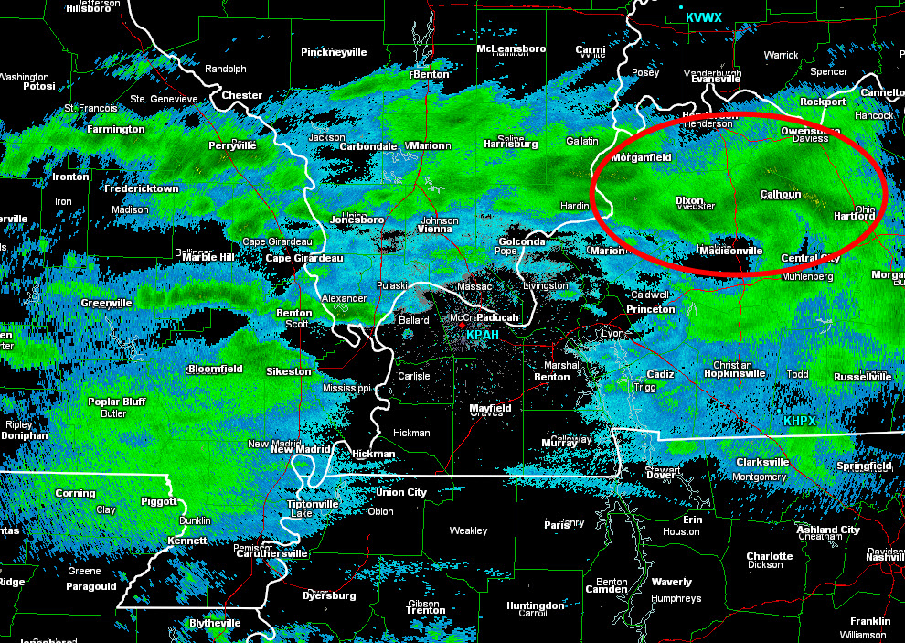
Radar animation…
Here is the radar animation from the Paducah, Kentucky National Weather Service. Note the heavier snow that formed near Owensboro, KY. This is one area that reported numerous wrecks. Daviess County, KY.
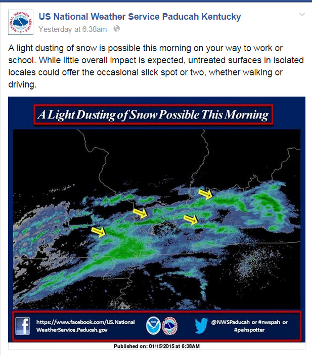
Let’s take a look at the Paducah Kentucky, NWS Facebook page. These are some of the posts leading up to the event…
You can see how the forecast “evolves” over time. As the event was underway they had to update the forecast with now-casts and special weather statements. If you only read the forecast from Wednesday afternoon then you would not have known that snow was also going to impact parts of western Kentucky. This is why you need to keep checking back (even hours before an event or during an event).
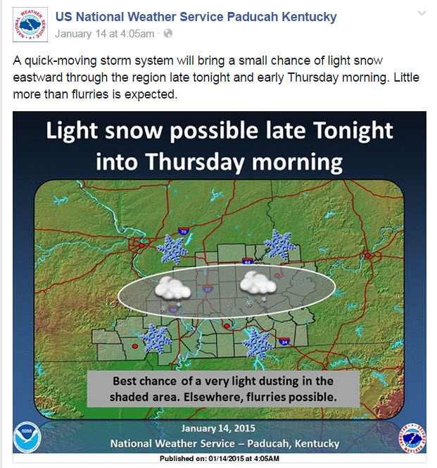
This update was issued at 4:30 AM on Wednesday morning. During this update only flurries (or a light dusting) were forecast. The forecast would later be updated with new information. The new forecast would increase snowfall amounts.
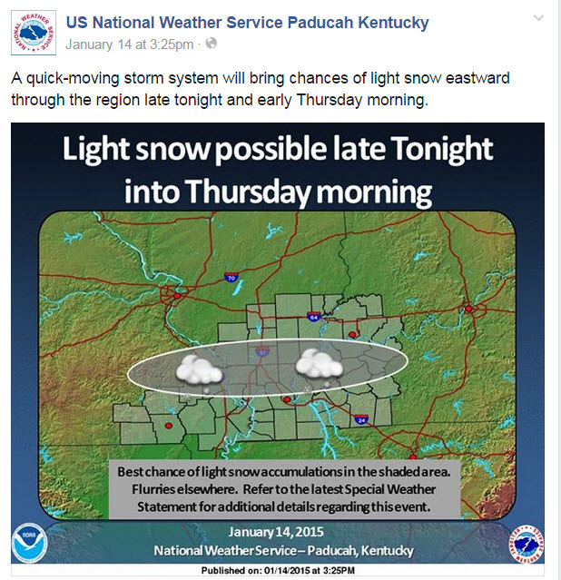
This next update was issued at 3:25 pm on Wednesday afternoon. At this point the NWS was talking about light snow and centered the concern from southeast Missouri into southern Illinois. The models were showing this to be the area of most concern.
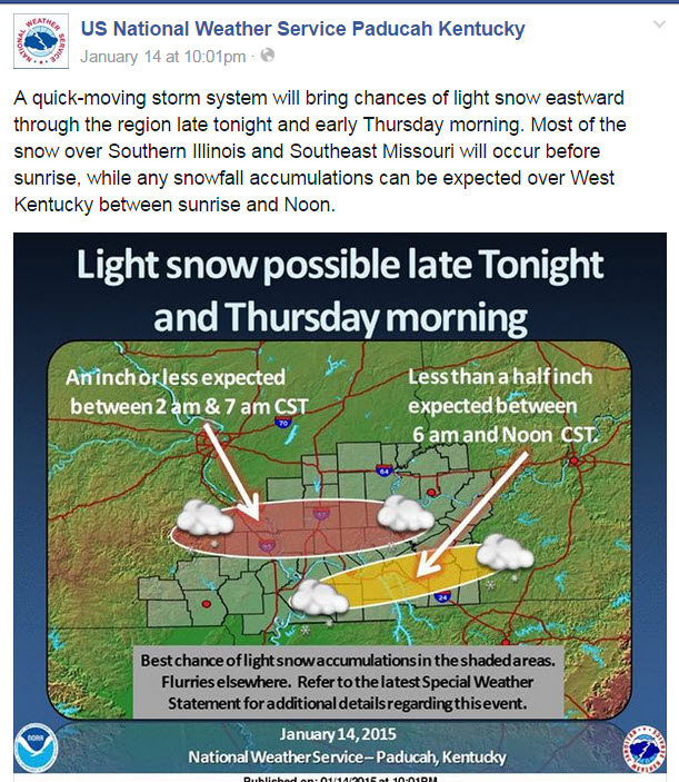
This next update was issued at 10 PM on Wednesday night. The event was only hours away. Snow had already developed over southern Missouri and was spreading eastward into southeast Missouri. At this point it was becoming a now-cast event (now-cast means the event is immediate and the forecast is being issued as the event is underway).
By this point the high resolution models were showing that snow would also develop over western Kentucky. You can see the NWS started to include western Kentucky in their snow forecast (not just MO/IL).
This next update was issued at 6:38 AM. The snow event was underway. Over the coming hours the snow would intensify over parts of southeast Missouri, far southern Illinois, and western Kentucky.
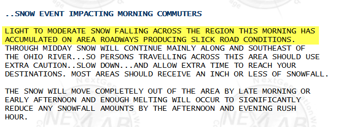
Here is one of the special weather statements that the Paducah, Kentucky National Weather Service issued:
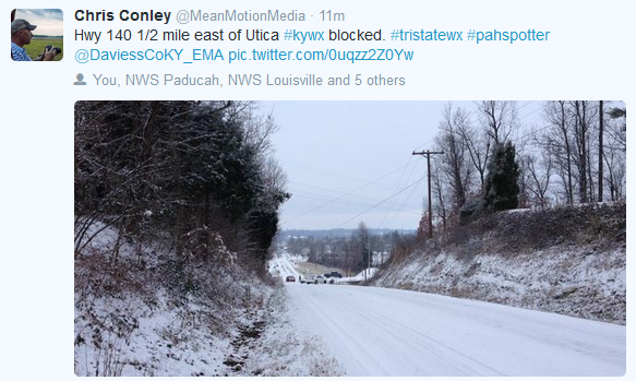
Numerous photographs indicated that many roadways became snow covered or partly snow covered. Under the snow was a thin layer of ice. Numerous accidents occurred across the area because of the icy roads.
The difficult part of this forecast was anticipating what the impact of the light snow event would be on area roadways. Or the extent of the problems.
It is important to remember that light snow and ice events can cause a lot of travel disruption in our region. People become overconfident when they see just a hint of snow on the ground. “It isn’t that bad because there isn’t that much snow” – this is how many people think. This leads to careless driving. Of course most accidents during winter storms can be contributed to careless driving. Whether there is 8″ of snow on the ground or a dusting of snow on the ground.
Would it surprise you if I told you accidents on icy roads kill at least twice the number of people annually than all other severe weather hazards COMBINED (tornadoes, hurricanes, lightning, floods, high winds). Annual injuries number well into the thousands, with many millions in property damage (icyroadsafety.com).
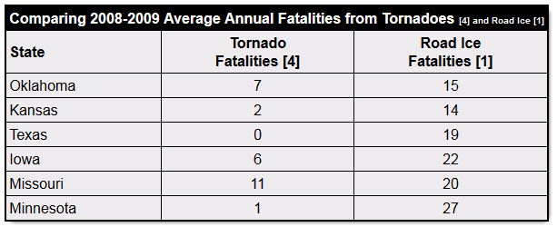
Imagine these statistics for a tornado outbreak in our region. Yet, these are not tornado deaths…these are winter storm deaths.
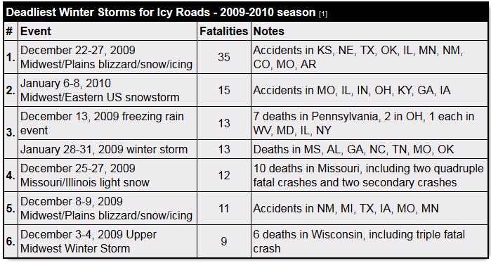
More people die in winter weather events than tornadoes. Yet, the attention is nowhere near the same.
These are topics that need to be considered and explored by forecasters and media. Are we spending enough time educating the public on these light winter precipitation events? Can we do a better job of informing the public of the threat to life and property?
As always, the public has a responsibility to use common sense during a weather event. But, that is true during severe weather season, as well. One can’t simply dismiss a hundred car accidents by blaming bad drivers. The same could be said about people who drive through flood waters, video tape tornadoes, stand out on a golf course during a lightning storm, or refuse to leave the coastline before a hurricane strikes.
The public has a responsibility and forecasters have a responsibility in dealing with these events.
Trusted weather sources…
It is also important to remember that you should use trusted weather sources for your weather information. There are a lot of Facebook and Twitter pages/accounts that post crazy snowfall maps days in advance of a winter storm. I do not support this behavior. It causes a lot of problems for those of us in the meteorological community. My policy is to issue a snowfall forecast map 24 hours before an event. Occasionally I might start posting maps 48 hours in advance. It depends on the storm.
We have a lot of great forecasters in our region. Our local media stations have great weather talent. We also have some great radio meteorologists. We have the National Weather Service Office located in Paducah, Kentucky. Utilize these resources.
I am going to post a video for you (all of you die-hard weather fans will enjoy it). The challenges of forecasting winter weather events.
Thanks Kelly Heidbreder for the partial definition of banding.

Who do you trust for your weather information and who holds them accountable?
I have studied weather in our region since the late 1970’s. I have 37 years of experience in observing our regions weather patterns. My degree is in Broadcast Meteorology from Mississippi State University and an Associate of Science (AS). I am currently working on my Bachelor’s Degree in Geoscience. Just need to finish two Spanish classes!
I am the Meteorologist for McCracken County Emergency Management.
There is a lot of noise on the internet. A lot of weather maps are posted without explanation. Over time you should learn who to trust for your weather information.
My forecast philosophy is simple and straight forward.
- Communicate in simple terms
- To be as accurate as possible within a reasonable time frame before an event
- Interact with you on Twitter, Facebook, and the blog
- Minimize the “hype” that you might see on television or through other weather sources
- Push you towards utilizing wall-to-wall LOCAL TV coverage during severe weather events
I am a recipient of the Mark Trail Award, WPSD Six Who Make A Difference Award, Kentucky Colonel, and the Caesar J. Fiamma” Award from the American Red Cross. In 2009 I was presented with the Kentucky Office of Highway Safety Award. I was recognized by the Kentucky House of Representatives for my service to the State of Kentucky leading up to several winter storms and severe weather outbreaks.
If you click on the image below you can read the Kentucky House of Representatives Resolution.

I am also President of the Shadow Angel Foundation which serves portions of western Kentucky and southern Illinois.

We have regional radars and local city radars – if a radar does not seem to be updating then try another one. Occasional browsers need their cache cleared. You may also try restarting your browser. That usually fixes the problem. Occasionally we do have a radar go down. That is why I have duplicates. Thus, if one fails then try another one.
If you have any problems then please send me an email beaudodson@usawx.com
WEATHER RADAR PAGE – Click here —
We also have a new national interactive radar – you can view that radar by clicking here.
Local interactive city radars include St Louis, Mt Vernon, Evansville, Poplar Bluff, Cape Girardeau, Marion, Paducah, Hopkinsville, Memphis, Nashville, Dyersburg, and all of eastern Kentucky – these are interactive radars. Local city radars – click here
NOTE: Occasionally you will see ground clutter on the radar (these are false echoes). Normally they show up close to the radar sites – including Paducah.

Regional Radar – Click on radar to take you our full radar page.


Regional Radar

Please visit your local National Weather Service Office by clicking here. The National Weather Service Office, for our region, is located in Paducah, Kentucky. They have a lot of maps and information on their site. Local people…local forecasters who care about our region.


Here is the official 6-10 day and 8-14 day temperature and precipitation outlook. Check the date stamp at the top of each image (so you understand the time frame).
The forecast maps below are issued by the Weather Prediction Center (NOAA).


The latest 8-14 day temperature and precipitation outlook. Note the dates are at the top of the image. These maps DO NOT tell you how high or low temperatures or precipitation will be. They simply give you the probability as to whether temperatures or precipitation will be above or below normal.


Many of my graphics are from www.weatherbell.com – a great resource for weather data, model data, and more


This blog was inspired by ABC 33/40’s Alabama Weather Blog – view their blog
Current tower cam view from the Weather Observatory- Click here for all cameras.

Southern Illinois Weather Observatory

The Weather Observatory

Southern Illinois Weather Observatory
WSIL TV 3 has a number of tower cameras. Click here for their tower camera page & Illinois Road Conditions

Marion, Illinois
WPSD TV 6 has a number of tower cameras. Click here for their tower camera page & Kentucky Road Conditions & Kentucky Highway and Interstate Cameras

Downtown Paducah, Kentucky
Benton, Kentucky Tower Camera – Click here for full view

Benton, Kentucky

I24 Paducah, Kentucky

I24 Mile Point 9 – Paducah, KY

I24 – Mile Point 3 Paducah, Kentucky

You can sign up for my AWARE email by clicking here I typically send out AWARE emails before severe weather, winter storms, or other active weather situations. I do not email watches or warnings. The emails are a basic “heads up” concerning incoming weather conditions.