
We have our first sponsor for the blog. Milner and Orr Funeral Home and Cremation Services located in Paducah, Kentucky and three other western Kentucky towns – at Milner and Orr they believe in families helping families.
![]()

This forecast update covers far southern Illinois, far southeast Missouri, and far western Kentucky. See the coverage map on the right side of the blog. Remember that weather evolves. Check back frequently for updates.
Friday – Morning fog possible – possibly some freezing fog. Watch bridges and overpasses if fog does develop. Some morning clouds giving way to sunshine. Milder temperatures than recent weeks. Highs will be in the upper 40’s and lower 50’s. Southwest winds at 5-10 mph becoming more southerly.
Morning School Bus Stop Weather – Some morning clouds and patchy fog. Not as cold as recent days. Temperatures will be in the
Afternoon School Bus Stop Weather – Quite a bit of sunshine. Milder than recent days. Temperatures will be in the 48-52 degree range.
Friday night – Partly cloudy in the early evening then becoming mostly cloudy late. Low temperatures in the upper 20’s and lower 30’s. Southerly winds at 5-10 mph.
Saturday – A mix of sun and clouds. Windy. Perhaps more clouds in the morning than the afternoon hours. Milder than recent weeks. High temperatures will be in the upper 40’s to lower 50’s Some data shows middle 50’s…but either way it will feel great. Southerly winds increasing to 10-20 mph during the afternoon hours. Winds may gust above 30 mph at times.
Saturday night – Increasing clouds. Turning cooler. Low temperatures will be in the lower 30’s. Winds becoming more west/northwest at 5-10 mph.
Sunday – Morning clouds will give way to afternoon sun. Temperatures will hold steady or slowly fall. Colder. Highs in the 40’s. Westerly winds at 5-10 mph.

Current Temperatures Around The Local Area


An explanation of what is happening in the atmosphere over the coming days…
We may have some fog this morning. If fog does develop then there could be some icing on area bridges, overpasses, and roadways. This is because the moisture from the fog causes water droplets to form on surfaces. When temperatures are below freezing this can cause problems.
The rest of today will be calm. We will see temperatures start to rise into the 40’s today and tomorrow! We should see some 50’s tomorrow, as well. Not sure if we can reach middle 50’s. We shall see. Either way it will feel better than it has in a long time. January has been quite cold.
A cold front arrives on Sunday. This front will bring clouds to the region on Saturday night and Sunday morning. Right now it appears the front will move through without precipitation.
Temperatures on Sunday won’t be as mild as Saturday. Expect mainly 40’s with perhaps falling temperatures during the afternoon hours.
Monday and Tuesday will be dry and calm. Temperatures in the 40’s.
How about our snow maker on Thursday…
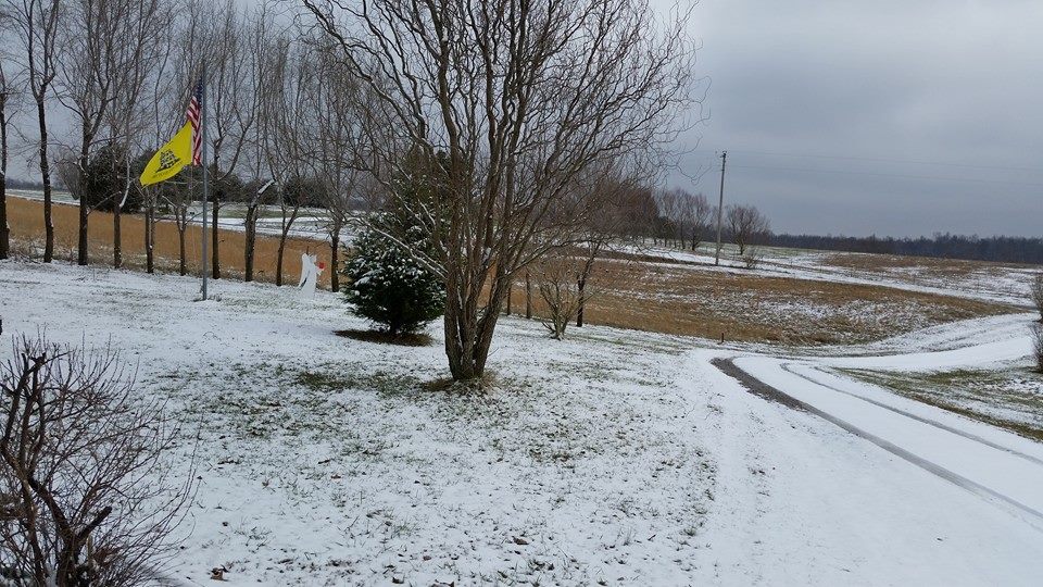
Terry Konemann (Pope County, IL) posted this photograph on her Facebook page
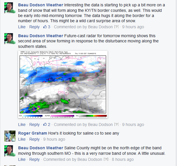
Well, our little snow maker what was like the little engine that could. It used up all the moisture it could muster. The overall forecast worked out quite well. There were changes that had to be made late Wednesday night, but that is why I tell you to check back frequently for updates during winter weather events. I was also posting updates on Facebook and Twitter as everything unfolded.
This was a post I made Wednesday night – this was one indication that the data was changing
I show you this so that you understand that during winter weather events you have to check back often for updates. Rarely does a winter weather event perform as expected. Normally these events are tricky to forecast from county to county. Also there are typically changes even while an event is underway. I have to figure out where banding might occur, where precipitation is ending or redeveloping faster than expected, and so on.
Bottom line…during winter weather events don’t just check the forecast once. Check my Facebook page, Twitter, and here on the blog (or other local weather sources) Almost without exception a winter forecast will change as the event moves into our region.
And if you missed the play by play updates on Facebook – here they are
The models picked up on the western Kentucky snowfall nicely (see above). They also had the Missouri/Illinois snow. Overall not too bad.
Unfortunately many roads were not treated. This led to a lot of accidents.
I always preach that our highest vehicle accident rates, injury rates, and fatalities are associated with small winter precipitation events. If you read my information enough then you will know that I am a big advocate that these events should get more attention than they do.
This was a morning rush hour event – red flag
This was an event where the roads were cold – red flag
This was an event where the models showed that snow would fall and accumulate – red flag
These events deserve more attention as they end up being the higher impact events of our winter season.
Our local National Weather Service and some other NWS offices continue to look into this subject and are trying to find better ways to communicate risk from small/light precipitation events. It is a work in progress. There were special weather statements out, but no advisories.
There is a movement towards “impact based advisories” vs advisories that are only issued for X amounts of snow. That means that even though a snow event may not reach the official criteria for an advisory or warning, the NWS can go ahead and issue an advisory. Officially the NWS issues a winter weather advisory or winter storm warning for a certain amount of measurable snowfall. But, again – those rules are changing and moving more towards impact based advisories/warnings.
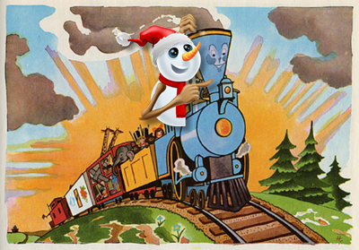
The Little Engine That Could
Here are some photographs from Twitter of some of the problems on area roadways
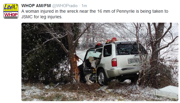
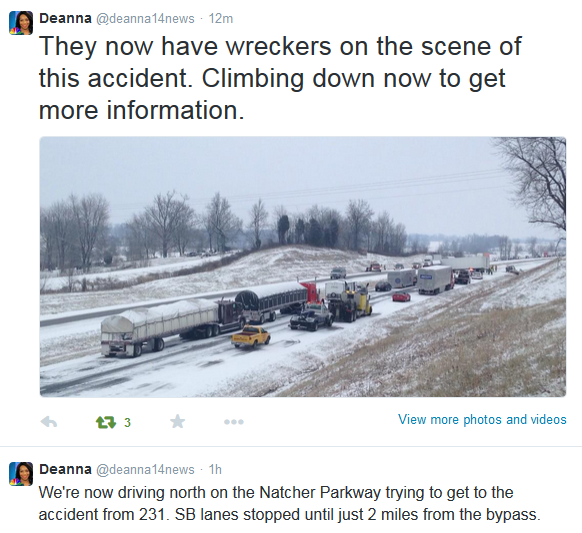
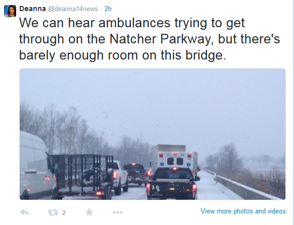
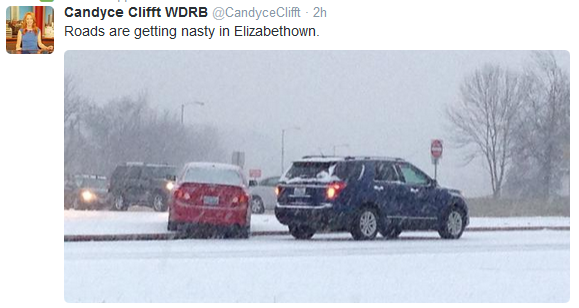
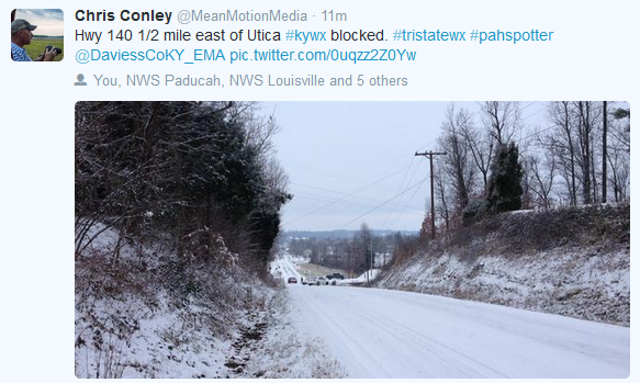
Lot of wrecks, lot of injuries, and some fatalities (unfortunately).
———————————————————————————————————————-
———————————————————————————————————————-
Did you know that the Weather Observatory is funded by people like you? I rely on ad’s on this blog and individual donations. PayPal also allows you to set up a monthly donation. I have had several people give $5, $10, and $20 a month. A recurring donation helps keep the weather information flowing. If you enjoy this blog, the Twitter account, the Facebook interaction, the weather radars, and all of the other information then consider making a donation or setting up a recurring donation (if you don’t use PayPal then contact me through email about how you can mail your donation) beaudodson@usawx.com Thank you!

Added the potential for freezing fog into the forecast for Friday morning. Use care on bridges and overpasses.

Freezing fog on Friday morning is my main concern. Fog can produce water droplets on bridges and overpasses. This can lead to patchy ice. If this develops then use care.
If there is any moisture left over from the snow that fell on Thursday then it could also refreeze.
Check out our newest sponsors $5 meal deal! The DQ Grill and Chill (located across from Noble Park in Paducah, Kentucky) is the newest WeatherTalk Blog sponsor! A local business helping to sponsor the weather information that you have come to love so much.
They also have a Facebook Page and I encourage you to check it out. DQ Grill and Chill on Facebook


The wild card tells you where the uncertainties are in the forecast
Wild card in this forecast – wild card in this forecast is whether or not there is some freezing fog on Friday morning.
Second wild card will be whether or not we can reach into the middle 50’s on Saturday. Crossing fingers!

Can we expect severe thunderstorms over the next 24 to 48 hours? Remember that a severe thunderstorm is defined as a thunderstorm that produces 58 mph winds or higher, quarter size hail or larger, and/or a tornado.
Thunderstorm threat level is ZERO


Will I need to take action?
Just watch the roads this morning in case there is some patchy ice from snow that fell yesterday or from morning fog.

How much precipitation should we expect over the next few days?
No significant precipitation is forecast through Sunday night.
We have a new sponsor! G&C Multi-Services out of Paducah, Kentucky. G & C Multi-Services is a service provider in Western Kentucky that provides industrial and commercial equipment fabrication, machine troubleshooting, repair and maintenance, and installation. They can custom fabricate steel, stainless, and aluminum products per customer specifications.
Visit their web-site here. Or click the ad below! They have a Facebook page and it can be viewed here.


No winter weather in the forecast through Sunday night.

This section of the blog is speculative forecast information. Because it is past the range of what meteorologists can forecast accurately, it should be considered speculation. Anything past day 5 is considered a long range forecast.
The long range continues to point towards above normal temperatures into next week. There continue to be signs that we will see colder than normal weather as we move towards the end of next week into the following. Perhaps a couple of sharp cold snaps are in the cards. Again, this is long range and subject to change.
Some hints of light rain on Tuesday or so. Iffy on that right now. We have a few disturbances to monitor next week. Each one will need to be tracked and monitored to see if it might produce some precipitation in our region. The overall pattern will be active next week over the eastern United States. The question is whether or not it will be active in our region. A lot of the data keeps precipitation around us but not over us.
I continue to watch the mid to late week system on the models. The data continues to paint a storm to move through the southern United States. Still questions on whether or not it will bring precipitation into our region. Still too far out.
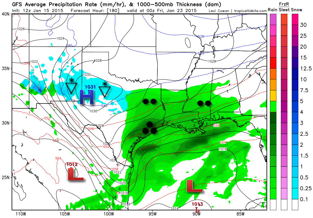
Here is the latest GFS model showing that particular storm. I have been showing you these maps for the past few days…tracking the changes. This map is from tropicaltidbits.com
You can see that today’s model runs take that system too far south to bring precipitation to our local counties. So, once again – we keep watching it.
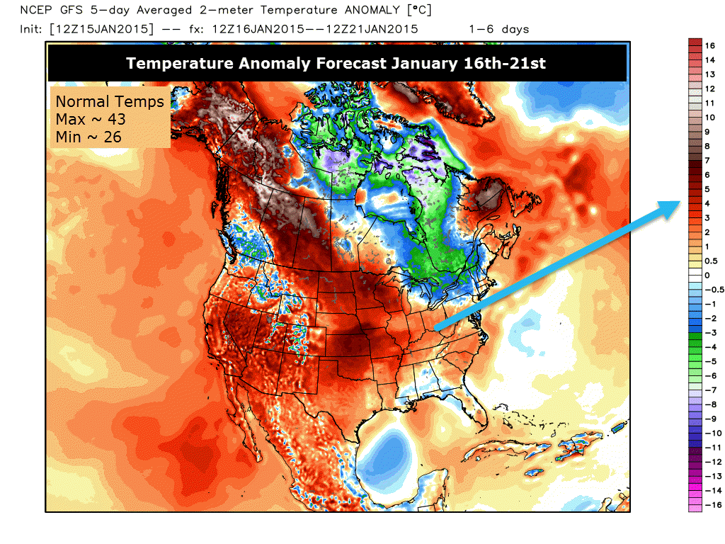
Let’s check out the temperature anomaly maps for this coming week. These maps tell you how many degrees above normal temperatures are forecast to average (over 5 day periods). Maps are from www.weatherbell.com
This map is for January 16th through the 21st. The five day averages indicate above normal temperatures for a large portion of the United States.
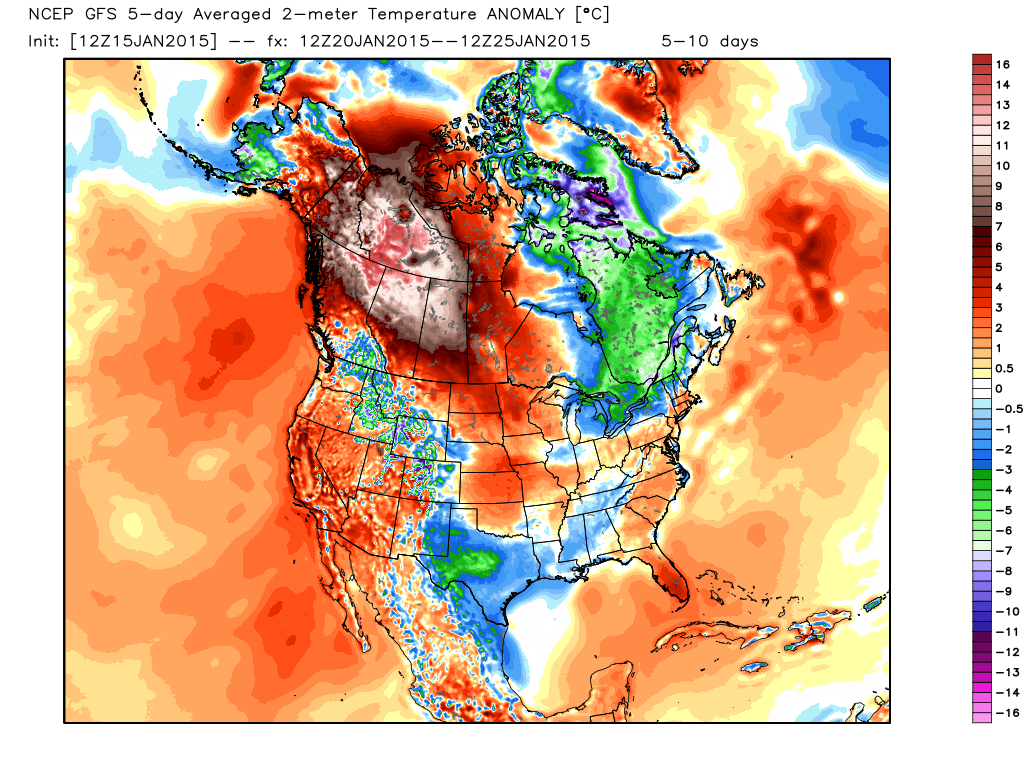
Here is the map for the following 5 day period. This map is for January 20th through January 25th. Still indicating above normal temperatures, but it appears to be breaking down the stronger signals for warmth.
Now you can see towards the end of the month the data is trending colder and colder. Now we are looking at below normal temperatures returning. Cold for the end of January into February?
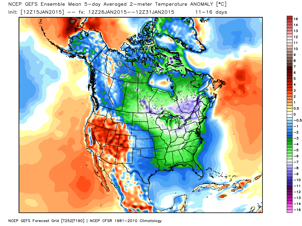
All signs are pointing to some pretty cold air as we move towards the end of next week into the following 8-10 day period.

Who do you trust for your weather information and who holds them accountable?
I have studied weather in our region since the late 1970’s. I have 37 years of experience in observing our regions weather patterns. My degree is in Broadcast Meteorology from Mississippi State University and an Associate of Science (AS). I am currently working on my Bachelor’s Degree in Geoscience. Just need to finish two Spanish classes!
I am the Meteorologist for McCracken County Emergency Management.
There is a lot of noise on the internet. A lot of weather maps are posted without explanation. Over time you should learn who to trust for your weather information. Whether they are television meteorologists, radio meteorologists, or private meteorologists like myself.
My forecast philosophy is simple and straight forward.
- Communicate in simple terms
- To be as accurate as possible within a reasonable time frame before an event
- Interact with you on Twitter, Facebook, and the blog
- Minimize the “hype” that you might see on television or through other weather sources
- Push you towards utilizing wall-to-wall LOCAL TV coverage during severe weather events
I am a recipient of the Mark Trail Award, WPSD Six Who Make A Difference Award, Kentucky Colonel, and the Caesar J. Fiamma” Award from the American Red Cross. In 2009 I was presented with the Kentucky Office of Highway Safety Award. I was recognized by the Kentucky House of Representatives for my service to the State of Kentucky leading up to several winter storms and severe weather outbreaks.
If you click on the image below you can read the Kentucky House of Representatives Resolution.

I am also President of the Shadow Angel Foundation which serves portions of western Kentucky and southern Illinois.

We have regional radars and local city radars – if a radar does not seem to be updating then try another one. Occasional browsers need their cache cleared. You may also try restarting your browser. That usually fixes the problem. Occasionally we do have a radar go down. That is why I have duplicates. Thus, if one fails then try another one.
If you have any problems then please send me an email beaudodson@usawx.com
WEATHER RADAR PAGE – Click here —
We also have a new national interactive radar – you can view that radar by clicking here.
Local interactive city radars include St Louis, Mt Vernon, Evansville, Poplar Bluff, Cape Girardeau, Marion, Paducah, Hopkinsville, Memphis, Nashville, Dyersburg, and all of eastern Kentucky – these are interactive radars. Local city radars – click here
NOTE: Occasionally you will see ground clutter on the radar (these are false echoes). Normally they show up close to the radar sites – including Paducah.

Regional Radar – Click on radar to take you our full radar page.


Regional Radar

Please visit your local National Weather Service Office by clicking here. The National Weather Service Office, for our region, is located in Paducah, Kentucky. They have a lot of maps and information on their site. Local people…local forecasters who care about our region.
Many of my graphics are from www.weatherbell.com – a great resource for weather data, model data, and more


This blog was inspired by ABC 33/40’s Alabama Weather Blog – view their blog
Current tower cam view from the Weather Observatory- Click here for all cameras.

Southern Illinois Weather Observatory

The Weather Observatory

Southern Illinois Weather Observatory
WSIL TV 3 has a number of tower cameras. Click here for their tower camera page & Illinois Road Conditions

Marion, Illinois
WPSD TV 6 has a number of tower cameras. Click here for their tower camera page & Kentucky Road Conditions & Kentucky Highway and Interstate Cameras

Downtown Paducah, Kentucky
Benton, Kentucky Tower Camera – Click here for full view

Benton, Kentucky

I24 Paducah, Kentucky

I24 Mile Point 9 – Paducah, KY

I24 – Mile Point 3 Paducah, Kentucky

You can sign up for my AWARE email by clicking here I typically send out AWARE emails before severe weather, winter storms, or other active weather situations. I do not email watches or warnings. The emails are a basic “heads up” concerning incoming weather conditions.