
.

This forecast update covers far southern Illinois, far southeast Missouri, and far western Kentucky. See the coverage map on the right side of the blog.
May 26, 2017
Friday Night Forecast Details:
Forecast: Drizzle possible. Partly to mostly cloudy. Warm and humid. Breezy, at times. A chance for showers and thunderstorms. Highest chance over southeast Missouri and northwest Tennessee. Perhaps extreme western Kentucky, as well. Some storms could produce hail and strong winds. Frequent lightning. Greatest risk is between 2 am and 9 am.
Temperatures: MO ~ 66 to 72 IL ~ 66 to 72 KY ~ 68 to 72 TN ~ 68 to 72
Winds: Southwest at 10 mph with gusts to 20 mph.
My confidence in the forecast verifying: Medium. Some adjustments are possible.
What impacts are anticipated from the weather? Locally heavy downpours and lightning. I will be monitoring the risk for a few intense thunderstorms with hail and high winds (northern counties).
Is severe weather expected? Monitor updates. I can’t rule out a few strong thunderstorms. Monitor updates.
The NWS defines severe weather as 58 mph winds or great, 1″ hail or larger, and/or tornadoes
What is the chance of precipitation? MO ~ 60% (mainly the southern portions of southeast Missouri) IL ~ 40% KY ~ 50% (mainly extreme western KY) TN ~ 60% (these numbers may need adjusting)
Coverage of precipitation: Perhaps scattered.
Should I cancel my outdoor plans? No, but I would monitor updated forecasts.
.
May 27, 2017
Saturday Forecast Details
Severe thunderstorms likely in the region late Saturday afternoon or night. Monitor updates.
Forecast: As always, severe weather is difficult to predict. Some guidance shows nothing happening and some show a damaging bow echo thunderstorm event. Monitor updates.
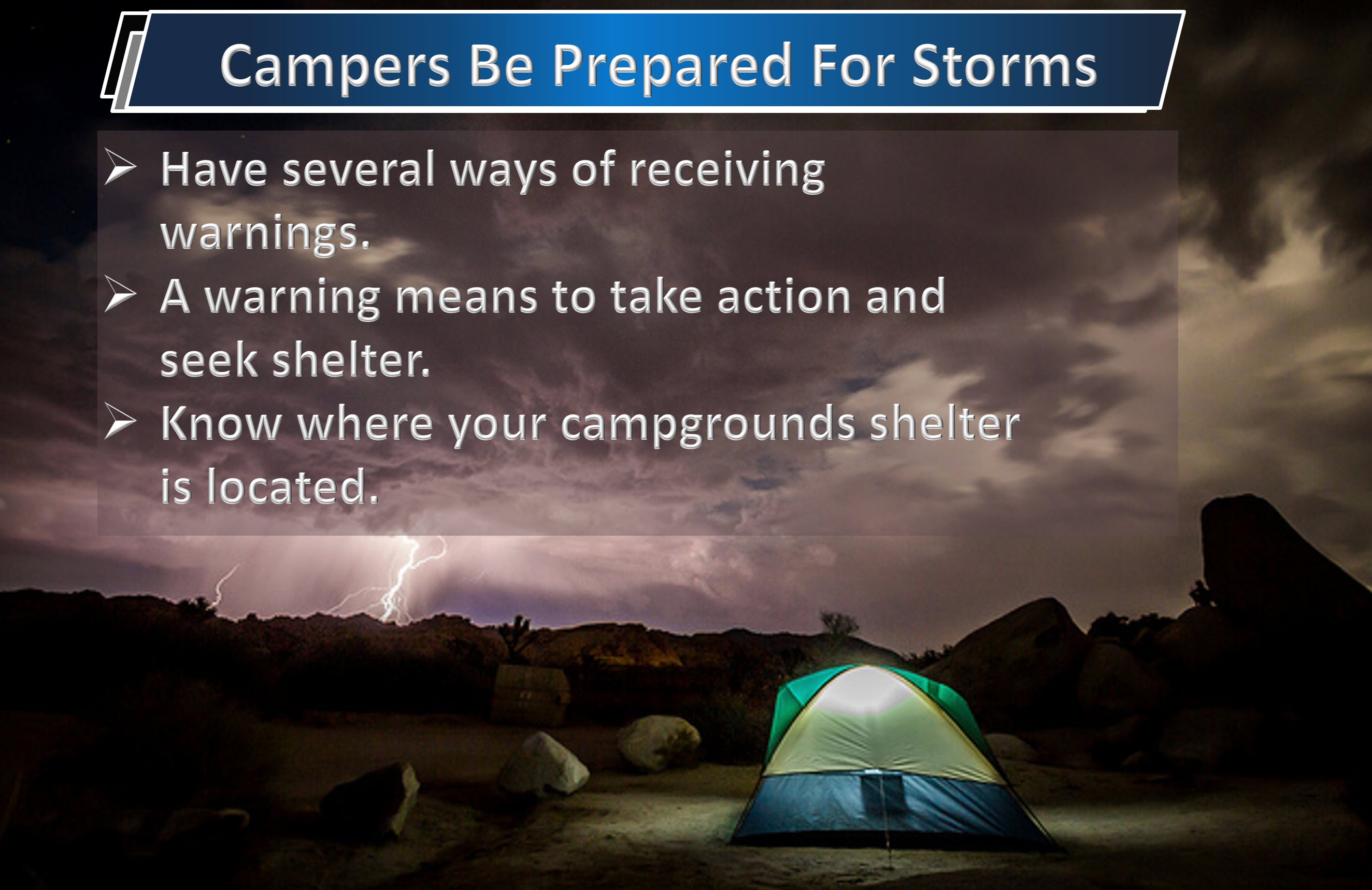
If you are camping make sure you have a weather radio or other means of receiving severe weather warnings and reports.
If thunderstorms don’t form during the morning hours, then most of Saturday might remain dry and muggy. Storms may hold off until evening.
Partly cloudy. Warm. Muggy. Heat index of 88 to 94 degrees. A 30% to 40% chance of morning showers and storms.
Thunderstorms becoming more likely late Saturday afternoon and evening. Some storms could become severe late in the day with large hail and damaging winds.
It is possible that most of the storms hold off until after 4 p.m. There is an 80% for a tornado or severe thunderstorm watch to be issued by late Saturday afternoon into the overnight hours.
Temperatures: MO ~ 86 to 88 IL 86 to 88 KY 85 to 90 TN 85 to 90
Winds: South and southwest wind at 6 to 12 mph with gusts to 25 mph.
What impacts are anticipated from the weather? Wet roadways. Lightning. A few storms could produce hail and high winds. The tornado risk is not zero.
My confidence in the forecast verifying: Medium. Some adjustments are possible.
Is severe weather expected? Yes. Severe storms are likely in the region. Perhaps the greatest risk will be after 4 p.m.
The NWS defines severe weather as 58 mph winds or great, 1″ hail or larger, and/or tornadoes
What is the chance of precipitation? MO ~ 40% morning and 50% afternoon IL ~ 30% morning and 50% KY ~ 30% morning and 40% afternoon TN ~ 30% morning and 30% afternoon
Coverage of precipitation: Low confidence on morning thunderstorm coverage. I can’t rule out some scattered storms. Much of the day may remain dry. Precipitation coverage would be more likely to increase late in the day into the evening hours.
Should I cancel my outdoor plans? No, but monitor updates. Have a severe weather safety plan.
.
Saturday Night Forecast Details:
Forecast: Becoming mostly cloudy. Warm and muggy during the evening hours. A line of intense thunderstorms likely to impact the region with high winds, large hail, and perhaps a few tornadoes.
There is an 80% for a tornado or severe thunderstorm watch to be issued for the region on Saturday night. There is a 90% for at least one or more severe thunderstorm or tornado warnings to be issued in our local region.
Temperatures: MO ~ 66 to 72 IL ~ 66 to 72 KY ~ 66 to 72 TN ~ 68 to 72
Winds: Southwest at 8 to 16 mph with higher gusts likely.
My confidence in the forecast verifying: Medium. Some adjustments are possible.
What impacts are anticipated from the weather? Wet roadways. Lightning. Damaging winds. Hail. Tornadoes possible. Flash flooding possible.
Is severe weather expected? Yes. Thunderstorms could be severe.
The NWS defines severe weather as 58 mph winds or great, 1″ hail or larger, and/or tornadoes
What is the chance of precipitation? MO ~ 70% IL ~ 80% KY ~ 80% TN ~ 80%
Coverage of precipitation: Numerous
Should I cancel my outdoor plans? Monitor updates. Have a severe weather safety plan. Severe storms are likely to impact the region on Saturday night. Be prepared to seek shelter if you are camping. Monitor all warnings. A warning means to seek shelter. Flash flooding is also a concern if thunderstorms train over the same areas. Avoid flooded roadways.
.
May 28, 2017
Sunday Forecast Details
Forecast: Partly to mostly cloudy. A 50% to 60% for additional showers and thunderstorms. A few storms could become severe.
Temperatures: MO ~ 76 to 82 IL 76 to 82 KY 76 to 82 TN 76 to 82
Winds: South and southwest winds at 10 to 20 mph becoming westerly and northwesterly as the cold front passes through the area.
What impacts are anticipated from the weather? Wet roadways. Lightning. Some storms could produce hail and high winds. The tornado risk is low, but not zero.
My confidence in the forecast verifying: Medium. Some adjustments are possible.
Is severe weather expected? Severe storms are possible on Sunday.
The NWS defines severe weather as 58 mph winds or great, 1″ hail or larger, and/or tornadoes
What is the chance of precipitation? MO ~ 50% IL ~ 50% KY ~ 60% TN ~ 60%
Coverage of precipitation: Scattered to perhaps numerous. The speed of the cold front will determine how fast our rain chances end on Sunday.
Should I cancel my outdoor plans? Monitor updates. Have a severe weather safety plan. Be prepared to seek shelter if you are camping. Monitor all warnings. A warning means to seek shelter. Flash flooding is also a concern if thunderstorms train over the same areas. Avoid flooded roadways.
.
Sunday Night Forecast Details:
Forecast: Partly cloudy. Isolated showers and thunderstorms early. Low confidence on any rain remaining in the area.
Temperatures: MO ~ 56 to 62 IL ~ 56 to 62 KY ~ 56 to 62 TN ~ 56 to 62
Winds: Northwest winds at 4 to 8 mph with gusts to 14 mph.
My confidence in the forecast verifying: Medium. Some adjustments are possible.
What impacts are anticipated from the weather? Patchy fog. Perhaps some wet roadways early in the evening. Lightning possible early in the evening. All of this should be on the way out by Sunday afternoon and night.
Is severe weather expected? The severe weather concerns should come to an end by Sunday night.
The NWS defines severe weather as 58 mph winds or great, 1″ hail or larger, and/or tornadoes
What is the chance of precipitation? MO ~ 20% IL ~ 20% KY ~ 30% (before 7 pm) TN ~ 30% (before 7 pm)
Coverage of precipitation: Rain will be coming to an end.
Should I cancel my outdoor plans? No, but perhaps check radars early in the evening.
.
May 29, 2017
Monday Forecast Details
Forecast: Perhaps some morning patchy fog. Mostly sunny. A few passing clouds. A pleasant day anticipated.
Temperatures: MO ~ 76 to 82 IL 76 to 82 KY 76 to 82 TN 78 to 82
Winds: West winds at 5 to 10 mph.
What impacts are anticipated from the weather? None.
My confidence in the forecast verifying: High. This forecast should verify.
Is severe weather expected? No.
The NWS defines severe weather as 58 mph winds or great, 1″ hail or larger, and/or tornadoes
What is the chance of precipitation? MO ~ 0% IL ~ 0% KY ~ 0% TN ~ 0%
Coverage of precipitation: None
Should I cancel my outdoor plans? No
.
Monday Night Forecast Details:
Forecast: Mostly clear. A few passing clouds.
Temperatures: MO ~ 55 to 60 IL ~ 55 to 60 KY ~ 55 to 60 TN ~ 55 to 60
Winds: West and northwest winds at 4 to 8 mph.
My confidence in the forecast verifying: Medium. Some adjustments are possible.
What impacts are anticipated from the weather? None
Is severe weather expected? No
The NWS defines severe weather as 58 mph winds or great, 1″ hail or larger, and/or tornadoes
What is the chance of precipitation? MO ~ 0% IL ~ 0% KY ~ 0% TN ~ 0%
Coverage of precipitation: None anticipated.
Should I cancel my outdoor plans? No
.
May 30, 2017
Tuesday Forecast Details
Forecast: Partly sunny.
Temperatures: MO ~ 76 to 82 IL 76 to 82 KY 78 to 84 TN 78 to 82
Winds: West winds at 5 to 10 mph.
What impacts are anticipated from the weather? None
My confidence in the forecast verifying: Medium. Some adjustments are possible.
Is severe weather expected? No.
The NWS defines severe weather as 58 mph winds or great, 1″ hail or larger, and/or tornadoes
What is the chance of precipitation? MO ~ 20% IL ~ 20% KY ~ 10% TN ~ 10%
Coverage of precipitation: Most likely none.
Should I cancel my outdoor plans? No
.
Tuesday Night Forecast Details:
Forecast: Partly cloudy. A slight chance of a shower or thunderstorm.
Temperatures: MO ~ 55 to 60 IL ~ 55 to 60 KY ~ 55 to 60 TN ~ 55 to 60
Winds: West and northwest winds at 5 mph.
My confidence in the forecast verifying: Medium. Some adjustments are possible.
What impacts are anticipated from the weather? Wet roadways. Lightning.
Is severe weather expected? No
The NWS defines severe weather as 58 mph winds or great, 1″ hail or larger, and/or tornadoes
What is the chance of precipitation? MO ~ 30% IL ~ 20% KY ~ 20% TN ~ 20%
Coverage of precipitation: Scattered.
Should I cancel my outdoor plans? No
.
May 31, 2017
Wednesday Forecast Details
Forecast: Partly sunny. A slight chance of showers and thunderstorms over southeast Missouri.
Temperatures: MO ~ 75 to 80 IL 75 to 80 KY 78 to 84 TN 78 to 82
Winds: West winds at 5 to 10 mph.
What impacts are anticipated from the weather? Wet roadways and lightning.
My confidence in the forecast verifying: Medium. Some adjustments are possible.
Is severe weather expected? No.
The NWS defines severe weather as 58 mph winds or great, 1″ hail or larger, and/or tornadoes
What is the chance of precipitation? MO ~ 40% IL ~ 30% KY ~ 30% TN ~ 30%
Coverage of precipitation: Scattered
Should I cancel my outdoor plans? No, but check back for updates
.
Wednesday Night Forecast Details:
Forecast: Partly cloudy. Showers and thunderstorms possible.
Temperatures: MO ~ 55 to 60 IL ~ 55 to 60 KY ~ 55 to 60 TN ~ 55 to 60
Winds: West and northwest winds at 5 mph.
My confidence in the forecast verifying: Medium. Some adjustments are possible.
What impacts are anticipated from the weather? Wet roadways. Lightning.
Is severe weather expected? Unlikely, but monitor updates.
The NWS defines severe weather as 58 mph winds or great, 1″ hail or larger, and/or tornadoes
What is the chance of precipitation? MO ~ 40% IL ~ 40% KY ~ 40% TN ~ 40%
Coverage of precipitation: Scattered.
Should I cancel my outdoor plans? Check back for updates on rain coverage
.
Don’t forget to check out the Southern Illinois Weather Observatory web-site for weather maps, tower cams, scanner feeds, radars, and much more! Click here
..

A severe thunderstorm is defined as a storm that produces quarter size hail or larger, 58 mph winds or greater, and/or a tornado. That is the official National Weather Service definition of a severe thunderstorm.
Friday night: A few storms could develop on Friday night. Confidence is rather low. IF storms were to form then they could produce strong and gusty winds, nickel size hail, and frequent lightning. Heavy downpours, as well. Again, low confidence about storms occurring on Friday night.
Saturday into Saturday night: A severe weather event is likely late Saturday afternoon and Saturday night. Much of Saturday may remain dry. The severe weather risk increases towards the evening and overnight hours.Large hail, damaging winds, and tornadoes can’t be ruled out. Monitor updates.
Large hail, damaging winds, and tornadoes can’t be ruled out. Monitor updates.
There is an 80% for a severe thunderstorm or tornado watch to be issued on Saturday afternoon and night.
There is a 90% for four or more severe thunderstorm or tornado warnings being issued by the National Weather Service.
Sunday into Monday: The cold front may not exit fast enough to prevent severe storms from forming on Sunday. Monitor updates. There is currently a 60% for a severe thunderstorm or tornado watch to be issued in my forecast area on Sunday..
Severe weather is not anticipated on Sunday night or Monday.

Weather Analysis for the coming week:
Interactive Weather Radar Page. Choose the city nearest your location: Click this link—
The focus of today’s discussion will be on the potential for severe thunderstorms on Saturday and Sunday.
As always, there is room for error when forecasting severe storms. Nothing is for certain until the storms form. Let’s keep that in mind.
The atmosphere, on Saturday and Saturday night, will support severe storms. The most likely scenario is a line of thunderstorms forming in Missouri between 2 pm and 5 pm. That line would then move east into our local area. If it is one squall line then the risk for damaging winds will increase. Winds of 70 mph or more will be possible.
Any line segments or bows could produce QLCS tornadoes. These are short-lived tornadoes that can cause damage. Most of our regions tornadoes are QLCS. They are typically embedded in the rain at the leading edge of a squall line (line of storms).
If supercells form then hail up to or larger than golf balls will be possible. Supercells would also produce damaging winds and isolated tornadoes.
If you are camping this weekend then please pay attention to the latest forecast. Severe weather is possible. A watch means to monitor updates. A warning means to take action and seek shelter.
Tornado or severe thunderstorm watches are probable Saturday afternoon and night.
The cold front may not make it across our region until Sunday. If that is the case then additional showers and thunderstorms are possible on Sunday. Some of these storms could also be severe. Lower confidence on what happens Sunday.
Be sure and monitor the latest watches and warnings. Have multiple ways of receiving severe weather information.
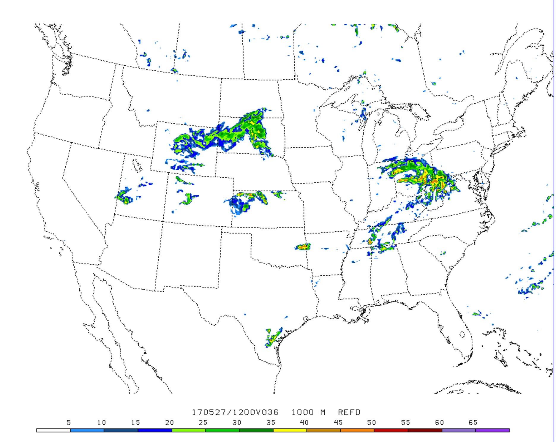
A few maps
Different models are showing different solutions for Saturday. That causes some concern about confidence levels.
Here is one of the WRF high-resolution models. This is for 5 p.m. on Saturday. It indicates a line of storms forming over southern Missouri and then spreading eastward.
Click images for a larger view

This is the SPC WRF model (below). It shows nothing at all happening at 7 p.m. on Saturday.
Typically, the SPC WRF does a great job with thunderstorm forecasting. Thus, this raises some questions about what happens on Saturday evening and night.
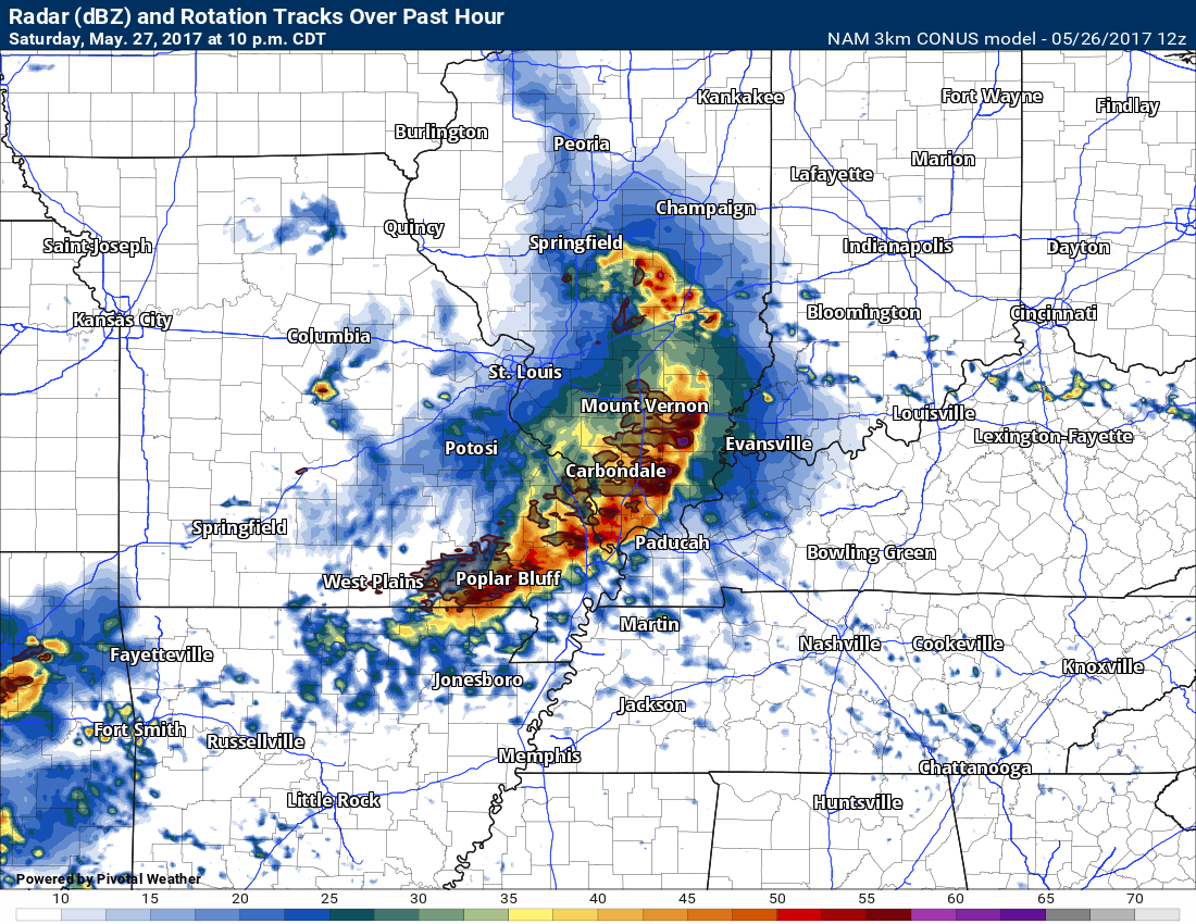
This next graphic is the high-resolution 3K NAM model
It shows a damaging bow echo racing across our region at speeds of 60 to 70 mph. This would produce damaging winds, hail, and even a tornado risk. One model. One opinion.
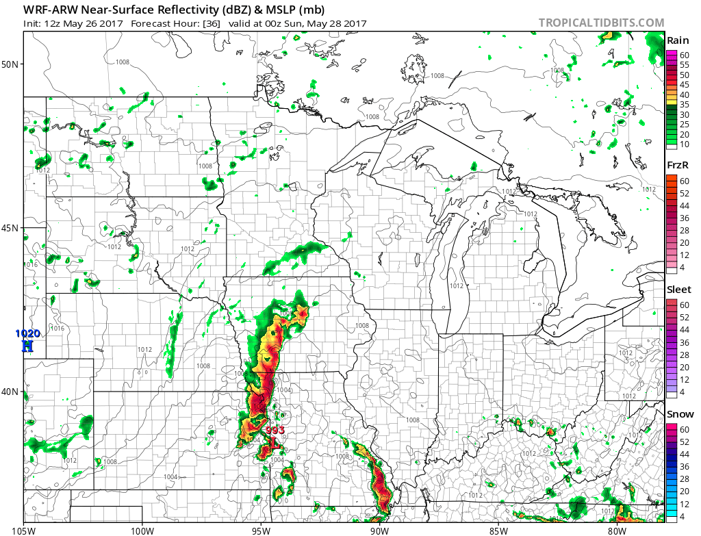
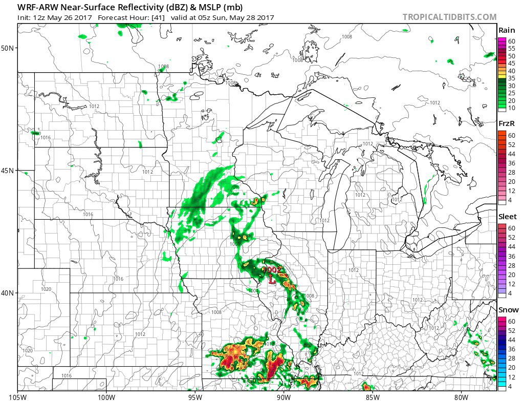
Let me show you yet another WRF model. This one is a bit different from the others. You can see how difficult this forecast is going to be.
This first image is 7 p.m. on Saturday. A line of storms over portions of southeast Missouri moving eastward. More storms further northwest in Missouri.
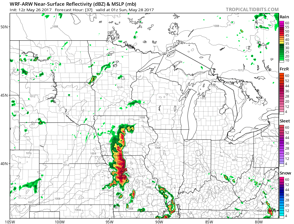
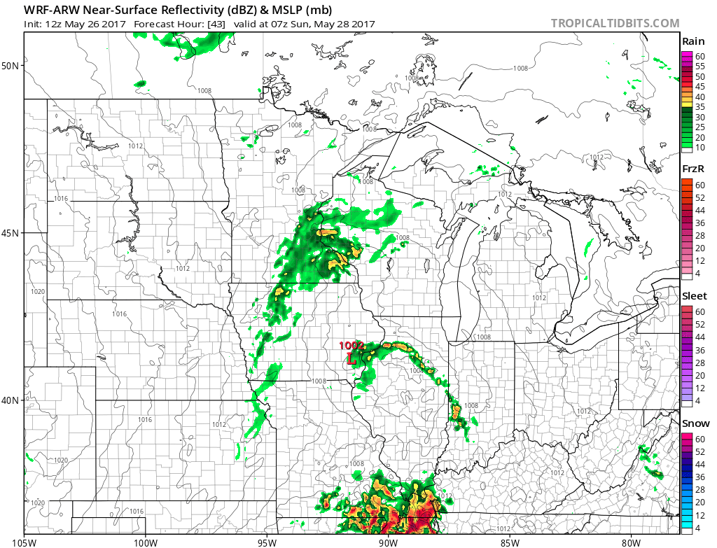
This next image is 8 p.m. The southeast Missouri line has weakened as it moved east.
This next image is 12 a.m. on Sunday. It shows yet another line moving into the region.
This next image is 2 a.m. on Sunday
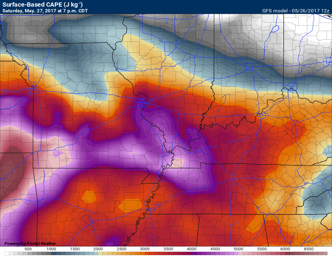
This next graphic is CAPE values. CAPE is a measure of energy in the atmosphere. These numbers are high. There are even 4000 to 5000 CAPE numbers over southern Illinois and southeast Missouri. Western Kentucky, as well. This is an unstable atmosphere.
What is CAPE ~ Click here for more details
These CAPE numerous would support very large hail. That would be most likely if supercells form. Most guidance shows a squall line and not supercells.
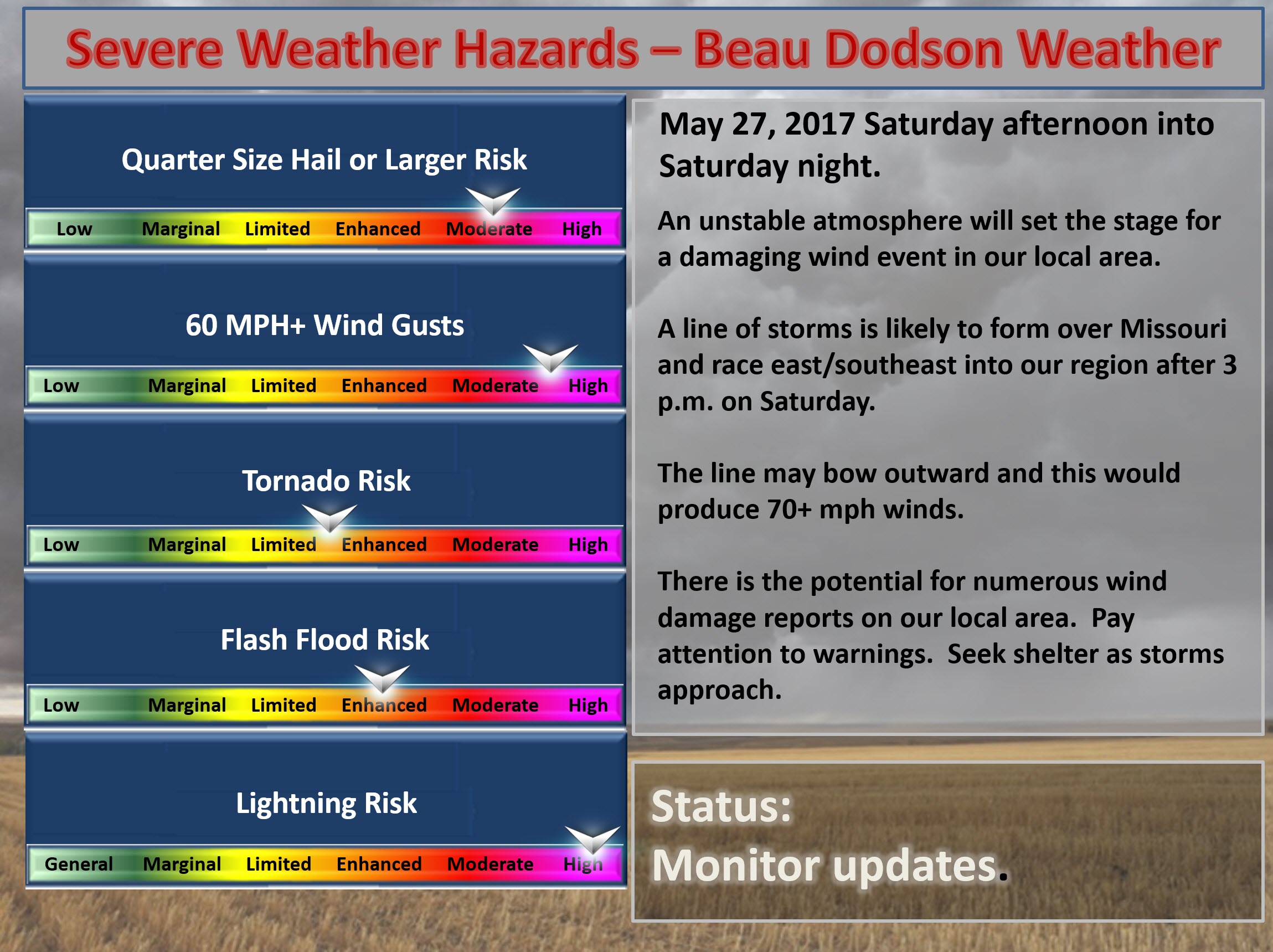
This next graphic shows you the risk matrix.

Find me on Twitter
.

We have regional radars and local city radars – if a radar does not update then try another one. Occasional browsers need their cache cleared. You may also try restarting your browser. That usually fixes the problem. Occasionally we do have a radar go down. That is why I have duplicates. Thus, if one fails then try another one.
During the winter you can track snow and ice by clicking the winterize button on the local city view interactive radars.
If you have any problems then please send me an email beaudodson@usawx.com
Interactive Weather Radar Page. Choose the city nearest your location: Click this link—
National interactive radar: Click this link.
Local interactive city radars include St Louis, Mt Vernon, Evansville, Poplar Bluff, Cape Girardeau, Marion, Paducah, Hopkinsville, Memphis, Nashville, Dyersburg, and all of eastern Kentucky. These are interactive radars. Local city radars – click here
.

The official 6-10 day and 8-14 day temperature and precipitation outlook. Check the date stamp at the top of each image (so you understand the time frame).
.
The forecast maps below are issued by the Weather Prediction Center (NOAA)
.

.

.
The latest 8-14 day temperature and precipitation outlook. Note the dates are at the top of the image. These maps DO NOT tell you how high or low temperatures or precipitation will be. They simply give you the probability as to whether temperatures or precipitation will be above or below normal.
.


.
The Beau Dodson Weather APP is ready for Apple and Android users. The purpose of this app is for me to deliver your text messages instantly. ATT and Verizon have not always been reliable when it comes to speed. The app allows instant delivery.
Some of you have asked if you can keep receiving the texts on your phone and the app. The answer to that is, yes. The Android app will automatically allow that to happen. On the Apple app, however, you will need to go into your app and click settings. Make sure the green tab is OFF. Off means you will still receive the texts to your phone and the app. If you have any questions, then email me at beaudodson@usawx.com
The app is for text subscribers.
The direct download, for the Apple app, can be viewed here
https://itunes.apple.com/us/app/id1190136514
If you have not signed up for the texting service then you may do so at www.beaudodsonweather.com

The Android app is also ready.
Remember, the app’s are for www.weathertalk.com subscribers. The app allows your to receive the text messages faster than ATT and Verizon.
Here is the download link for the Android version Click Here

——————————————————–
If you have not signed up for the texts messages, then please do. Link www.beaudodsonweather.com
Your support helps with the following:

and


Who do you trust for your weather information and who holds them accountable?
I have studied weather in our region since the late 1970’s. I have 39 years of experience in observing our regions weather patterns. My degree is in Broadcast Meteorology and a Bachelor’s of Science.
My resume includes:
Member of the American Meteorological Society.
NOAA Weather-Ready Nation Ambassador.
Meteorologist for McCracken County Emergency Management. I served from 2005 through 2015.
Meteorologist for McCracken County Rescue. 2015 through current
I own and operate the Southern Illinois Weather Observatory.
I am the chief meteorologist for Weather Talk LLC. I am the owner of Weather Talk LLC.
I am also a business owner in western Kentucky.
Recipient of the Mark Trail Award, WPSD Six Who Make A Difference Award, Kentucky Colonel, and the Caesar J. Fiamma” Award from the American Red Cross.
In 2005 I helped open the largest American Cross shelter in U.S. history in Houston, Texas. I was deployed to help after Hurricane Katrina and Hurricane Rita. I was a shelter manager of one of the Houston, Texas shelter divisions.
In 2009 I was presented with the Kentucky Office of Highway Safety Award.
Recognized by the Kentucky House of Representatives for my service to the State of Kentucky leading up to several winter storms and severe weather outbreaks.
If you click on the image below you can read the Kentucky House of Representatives Resolution.

I am also President of the Shadow Angel Foundation which serves portions of western Kentucky and southern Illinois.
There is a lot of noise on the internet. A lot of weather maps are posted without explanation. Over time you should learn who to trust for your weather information.
My forecast philosophy is simple and straight forward.
- Communicate in simple terms
- To be as accurate as possible within a reasonable time frame before an event
- Interact with you on Twitter, Facebook, email, texts, and this blog
- Minimize the “hype” that you might see on some television stations or through other weather sources
- Push you towards utilizing wall-to-wall LOCAL TV coverage during severe weather events
Many of the graphics on this page are from www.weatherbell.com
WeatherBell is a great resource for weather model guidance.


You can sign up for my AWARE email by clicking here I typically send out AWARE emails before severe weather, winter storms, or other active weather situations. I do not email watches or warnings. The emails are a basic “heads up” concerning incoming weather conditions