We have our first sponsor for the blog. Milner and Orr Funeral Home and Cremation Services located in Paducah, Kentucky and three other western Kentucky towns – at Milner and Orr they believe in families helping families.
![]()

This forecast update covers far southern Illinois, far southeast Missouri, and far western Kentucky. See the coverage map on the right side of the blog.
Remember that weather evolves. Check back frequently for updates, especially during active weather.
Monday – Quite a few clouds today. Above normal temperatures in the morning and seasonable temperatures throughout the day. Highs in the 40’s. Northwest winds at 5-10 mph. My confidence in this part of the forecast verifying is high
WEATHER RADAR PAGE – Click here
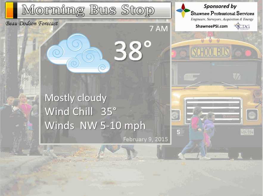
Morning School Bus Stop Weather – Quite a few clouds. Not too bad in the temperature department with morning temperatures in the upper 30’s to around 40. Northwest winds at 5-10 mph. Chance of school being delayed because of the weather 0%
—————————————————————————————-
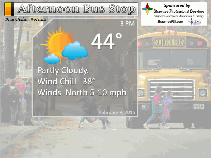
Afternoon School Bus Stop Weather – Some clouds in the afternoon, as well. Temperatures will be in the 40’s. Not too bad for February. Northwest winds at 5-10 mph.
Monday night – Clearing and cool. Lows in the 20’s to around 30 degrees. Northwest winds at 5-10 mph. My confidence in this part of the forecast verifying is high
Tuesday – Mostly sunny sky conditions. Cool, but not bad for February. Highs will be in the 40’s. Northeast winds at 5-10 mph. My confidence in this part of the forecast verifying is high
Tuesday night – Mostly clear. Lows in the upper 20’s to around 30 degrees. Northeast winds perhaps becoming east late at night at 5-10 mph. My confidence in this part of the forecast verifying is high
Wednesday – Partly sunny and mild for February (ahead of the next cold front). Highs around 48 to 54 degrees Southerly winds at 10-15 mph. My confidence in this part of the forecast verifying is high

The School Bus Stop Forecast is brought to your by Shawnee Professional Services. For more information click here

Shawnee Professional Services & Civil Design Group have been providing Land Surveying, Engineering, Grant Administration and Acquisition services for the past 20 years.
Currently Licensed in Illinois, Kentucky, Missouri, Indiana, and Tennessee; please contact Shawnee for any Land Surveying or Engineering needs.
Shawnee’s company size allows them to devote individual attention to each client and to approach each project with the required thoroughness to successfully complete the project, large or small.
Shawnee combines innovative thinking and proven techniques, completing projects cost-effectively for their clients. Visit Shawnee’s website at shawneepsi.com for more information. Shawnee has offices in Paducah, KY, Vienna, IL and Benton, IL.
Current Temperatures Around The Local Area


An explanation of what is happening in the atmosphere over the coming days…
Highlights…
1. A mostly dry week ahead
2. Colder – especially the last half of the week
3. A few cold fronts – they could bring a light shower or snow shower. One on Wednesday night another one towards the weekend (SAT or SUN)
4. Bitter cold this coming weekend
5. More active pattern developing in the long range
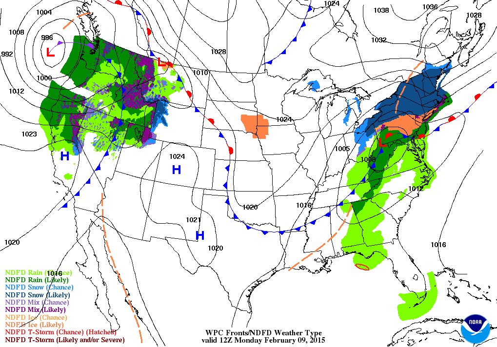
A cold front moved through the area on Sunday evening. This front has brought an end to our spring like temperatures. You knew it wouldn’t last! Not in February. But, your Monday isn’t going to be anything extreme, either. More seasonable temperatures vs the well above normal readings we witnessed over the weekend.
This weather blog is still in WINTER MODE! We have several weeks to go and snow fans should not give up on the chances for white gold. I know it has been a disappointing winter. My winter forecast was dry and cool – so this is not a shocker on the lack of precipitation. The charts do appear to pick up as we move into the last half of February. So, for all of you guys and gals who keep searching for the potential of snow – just keep checking back. There are systems to monitor in the long range. This could end up the most active period of the winter for our region.
Clouds will be difficult to move out on Monday.
Let’s take a look at today’s weather map – the cold front is now well to our south. If you read yesterdays blog then you will remember the cold front was to our north.
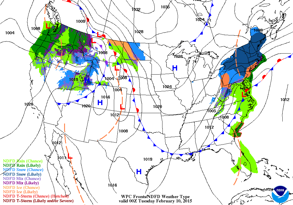
And, yes – that is another BIG snowstorm for the northeast. They have hit the lottery on snow totals.
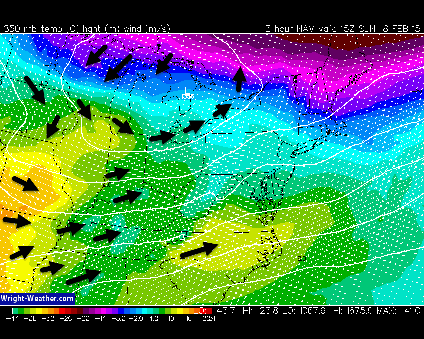
When we think about warmer air or colder air moving into the region, forecasters typically check the 850 mb map. The 850 mb level of the atmosphere is about 1500 meters above the surface. What I look for is what direction those winds are coming from. If they are coming from the southwest or south then typically that is going to bring warm air advection. Warm air moving into our region. If they are out of the north then colder air is advecting into our region.
Let me show you an example. This first map is from Sunday (when it was mild). See the warmer colors? You can also see the wind barbs are coming out of the southwest. Thus, Sunday brought mild readings into the region (ahead of the cold front). I drew in some of the wind lines with black arrows (so you can see what direction they are coming from)
There is an 850 mb low over the Great Lakes (thus the counter-clockwise formation of the areas)
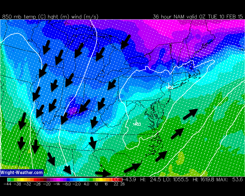
Now, that was Sunday afternoon. Let’s take a look at what is happening on Monday. Cold air advection behind the cold front! Thus, it will be colder on Monday into Tuesday. You can see a weak 850 mb low centered over Virginia. We are on the back side of that low (thus the northeast/northerly winds)
The dry pattern continues into the upcoming work week. Not a good sign for the drought.
We should warm up again on Wednesday. Highs near or above 50 degrees. Not bad, but it won’t last. Roller-coaster temperature ride.
Another cold front arrives on Wednesday evening. This front should be dry, as well. Perhaps a small chance for a sprinkle or flurry, but nothing to write home about and more likely than not it will be dry across most of our region. This sharp front will usher in colder temperatures and gusty winds.
As we push into the last half of the week the weather will also be mostly dry or dry.
I am watching a frontal system for the weekend. Maybe some snow showers along it? Looks moisture starved, but I will monitor it.
Strong Canadian high pressure will be in charge of our weather late this week. Remember that when high pressure comes out of Canada, during the winter months, it means cold air. The strong the high the colder the air.
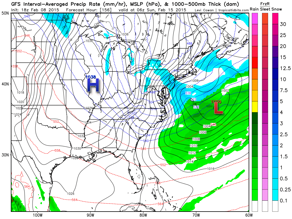
Let’s take a look at that high pressure center. You can see it centered over Illinois. Cold air underneath the weekend high.
There is some hope in the long range part of today’s update (and if you missed Saturday and Sunday’s update then check them out).
It will feel like winter this week…temperature wise (Wednesday might be the exception). Precipitation wise…not so much. For those who have to milk the cows you will be cursing the temperatures by late week. More teens for morning lows.
Sorry, I could not find a shivering cow.
Let’s take a look at temperatures on Wednesday ahead of that cold front. Not bad…not bad 🙂 – for February, at least.
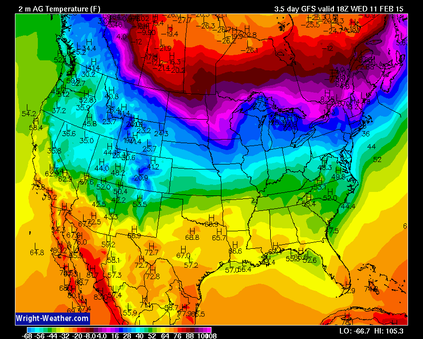
But, watch what happens once the front moves through our region. Brrr
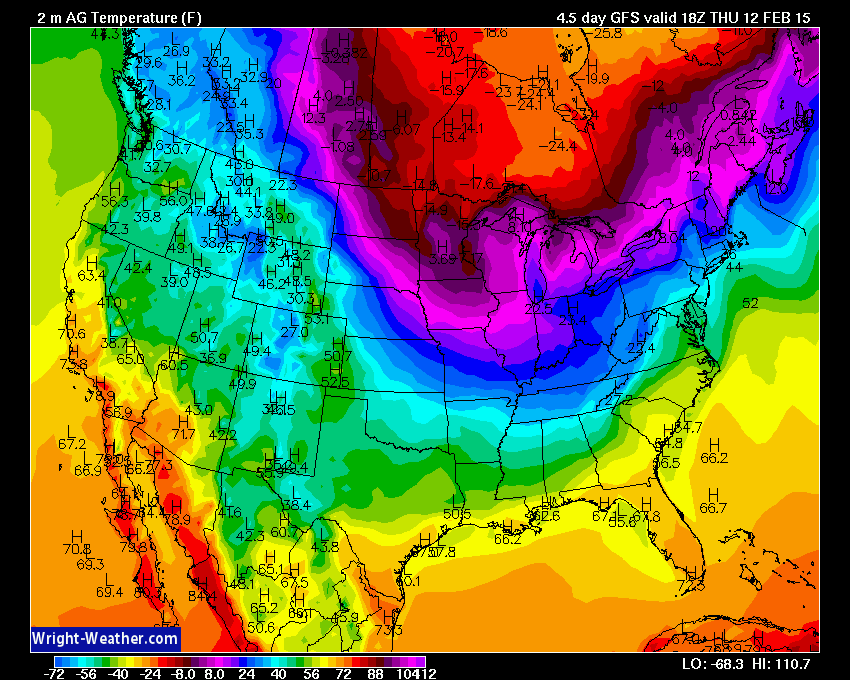
These are Thursday afternoon temperatures. 20’s for highs? Appears to be the case. Teens on Thursday night for low temperatures. Again, it will feel like winter (just without the snow). Image from www.wright-weather.com
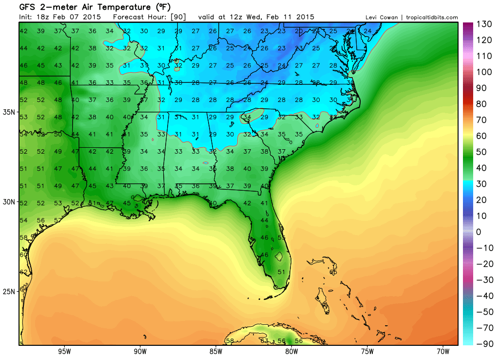
Let’s zoom in on those maps a bit and see what low temperatures are forecast to be later this week
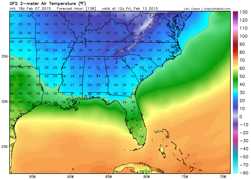
Here are the Wednesday morning low temperatures (ahead of the cold front). Click each image to see the full view. Images are from tropicaltidbits.com
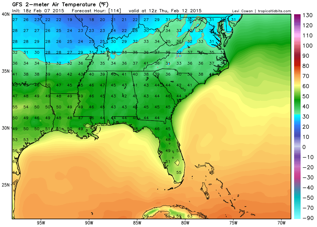
Here are the Thursday morning low temperatures behind the cold front
And, let’s check out the Friday morning low temperatures – brrr
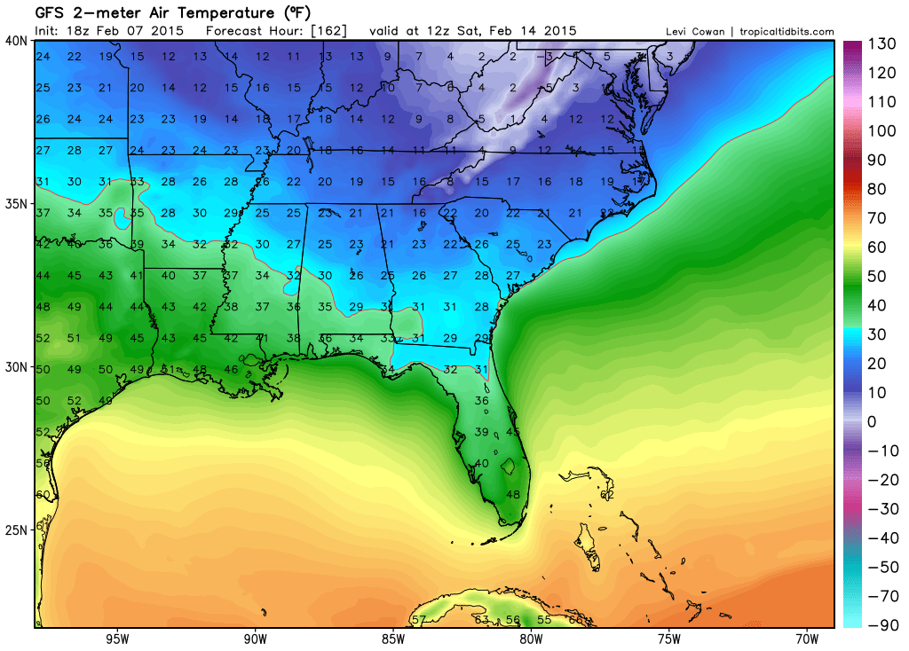
Temperatures could be lower if the high pressure moves a bit further southwest
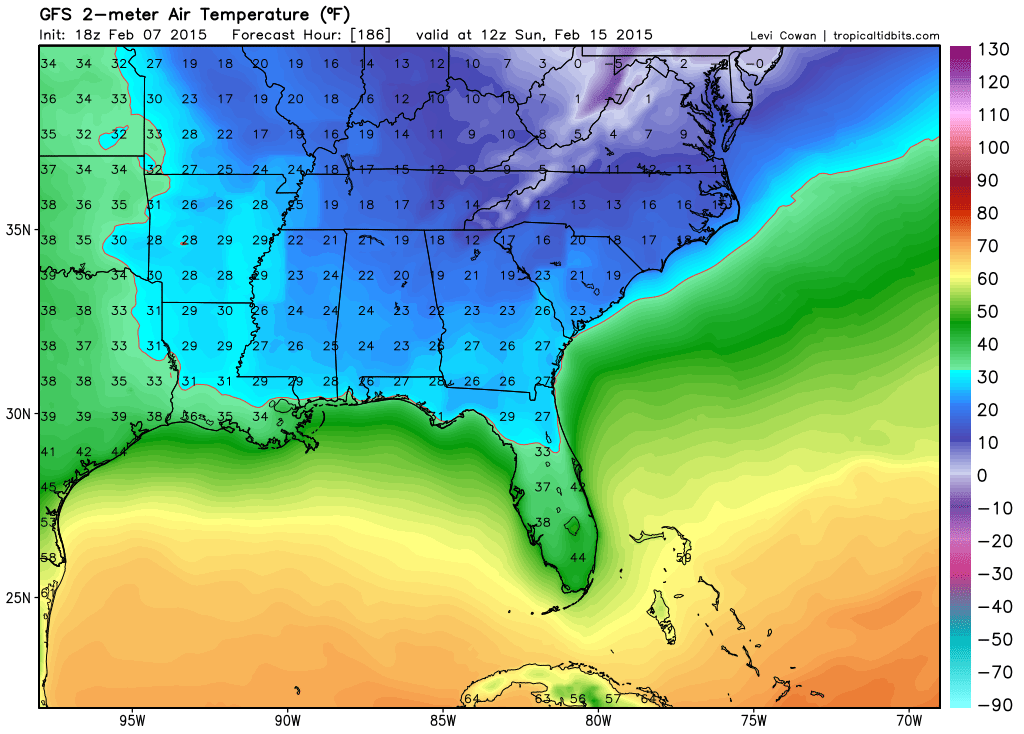
And, finally – let’s pull ahead to the weekend. Low temperatures for Saturday and Sunday will be on the chilly side, as well. (could even be colder than this – depending on where the center of the high pressure moves)
and Sunday (could even be colder than this – depending on where the center of the high pressure moves)
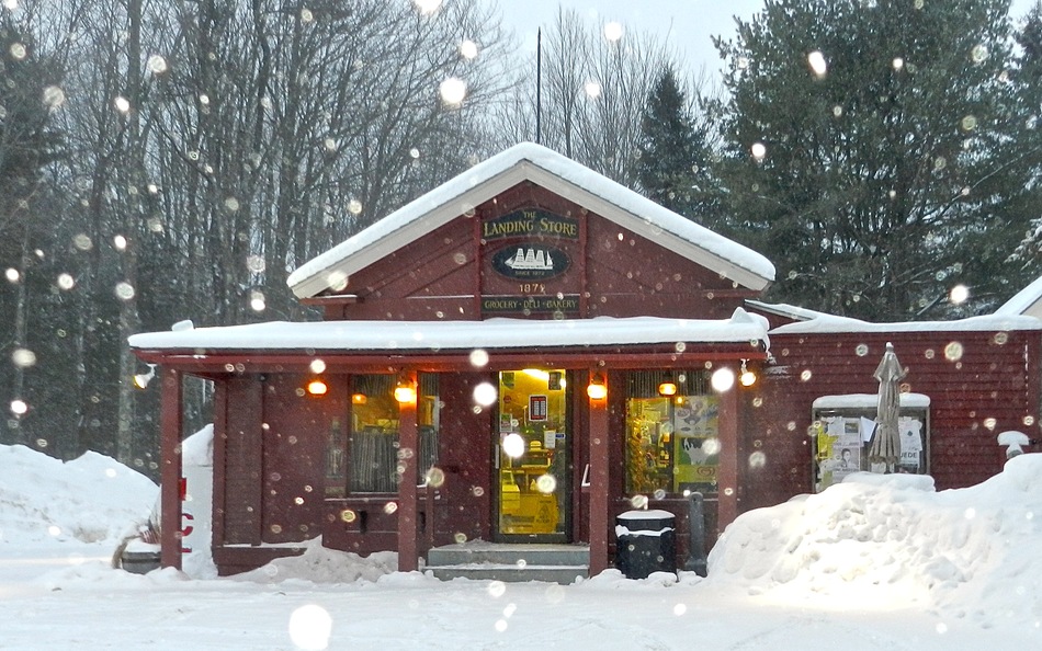
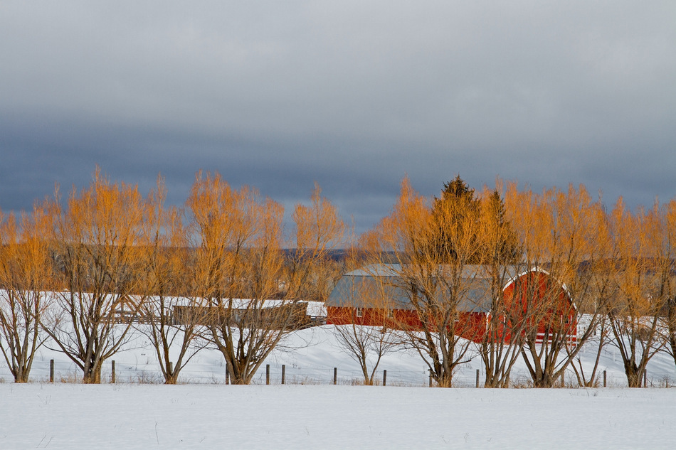
Since we don’t have any snow to look at – how about a snow photograph or two? These photographs are from the wunderground.com web-site
This first photograph is from Kennebunk, Maine. You can read more about the photographer by clicking here.
The second photograph is from Tetonia, Idaho. More about the photographer here
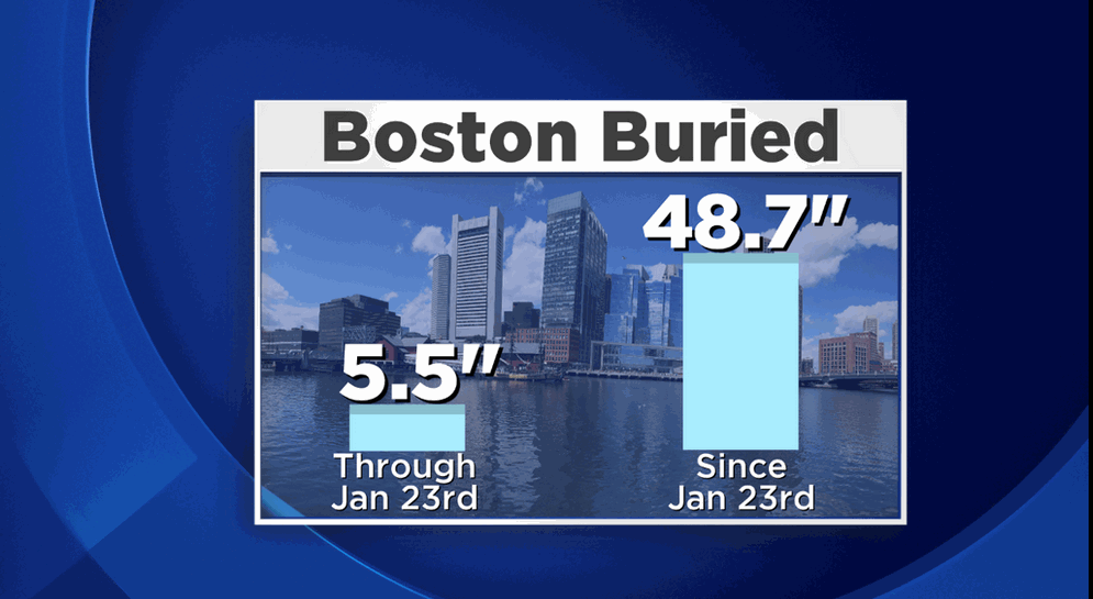
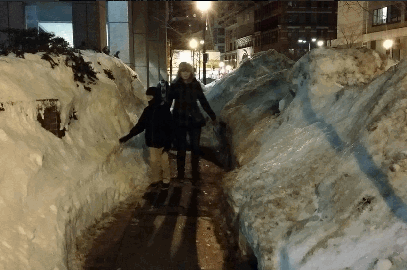
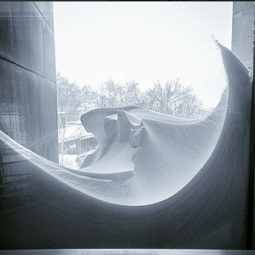
Folks, Boston has had a LOT of snow over the last couple of weeks. Just how much snow 🙂 – well, since you asked
I found these 3 images on Twitter. Sigh goes all of the snow lovers in the group…

WANT TO HELP SUPPORT THIS BLOG AND COVER EXPENSES?
Did you know that the Weather Observatory is funded by people like you? I rely on ad’s on this blog and individual donations. PayPal also allows you to set up a monthly recurring donation. I have had several people give $5, $10, and $20 a month. A recurring donation helps keep the weather information flowing. If you enjoy this blog, the Twitter account, the Facebook interaction, the weather radars, and all of the other information then consider making a donation or setting up a recurring donation (if you don’t use PayPal then contact me through email about how you can mail a donation) beaudodson@usawx.com
Or mail a check to
Beau Dodson
3954 Mermet Road
Belknap, IL
62908
Thank you for your support!

Adjusted temperatures a little bit, otherwise no major changes to the forecast.

No major weather concerns today.
Check out our newest sponsors $5 meal! The DQ Grill and Chill (located across from Noble Park in Paducah, Kentucky) is the newest WeatherTalk Blog sponsor! A local business helping to sponsor the weather information that you have come to love so much.
They have a Facebook Page and I encourage you to check it out. DQ Grill and Chill on Facebook


The wild card tells you where the uncertainties are in the forecast
Wild card in this forecast – The wild card today is not very exciting. How about whether we can push some clouds out of the area on Monday. They might be stubborn to leave.

Can we expect severe thunderstorms over the next 24 to 48 hours? Remember that a severe thunderstorm is defined as a thunderstorm that produces 58 mph winds or higher, quarter size hail or larger, and/or a tornado.
Thunderstorm threat level is ZERO


Will I need to take action?
No weather action required today. Fairly calm forecast. Again!

How much precipitation should we expect over the next few days?
No rain or snow today or tonight.
We have a new sponsor! G&C Multi-Services out of Paducah, Kentucky. G & C Multi-Services is a service provider in Western Kentucky that provides industrial and commercial equipment fabrication, machine troubleshooting, repair and maintenance, and installation. They can custom fabricate steel, stainless, and aluminum products per customer specifications.
Visit their web-site here. Or click the ad below! They have a Facebook page and it can be viewed here.


No winter weather today, tomorrow, or Wednesday. Sorry snow fans (I think I have said that all winter long).
A weak system over the upcoming weekend could bring snow showers. Still too far out for details on that one.
No promises but next week and the following week should bring several opportunities for precipitation. Will that be rain or snow (or both) – stay tuned. At least we DO have something to track.
Jim Rasor (WSIL) has a new blog. Check it out when you have time. http://mylocalweather.net/forum/home

This section of the blog is speculative forecast information. Because it is past the range of what meteorologists can forecast accurately, it should be considered speculation. Anything past day 5 is considered a long range forecast.
Some of this is from Sunday’s update. Nothing has changed and my thoughts remain on us entering a more active period the last 2 weeks of the month – the 16th onward. Whether that means rain or snow or both – that is the question.
Well, what is going to happen the rest of the month? Although long range forecasting is a bit of a gamble…there are some signals we can look at for this week and next week. A lot of those signals look pretty darn cold. A large high pressure center is forecast to push out of Canada next week (week of the 16th-21st).
When high pressure moves down from Canada, during the winter months, you can expect a lot of cold air underneath that high pressure. And, it appears that is what will happen for our region.
A bit of a battle is going to set up between the above and below normal temperatures for the rest of February. A lot of the data indicates northwest flow. What is northwest flow and what does it mean for our region?
When I tell you northwest flow is developing, in the winter, then it usually means drier than normal conditions and colder than normal. That appears to be where we are heading for the next 2 weeks.
This coming weekend might bring some light snow showers with a fast moving system coming out of the Northern Plains. Iffy at this point – will monitor and update as more data becomes available.
The big question is whether we can pull off a southwest storm system into this mix. A storm coming out of the southwest usually means a lot of precipitation for someone in the Ohio or Tennessee Valley southward. If they go too far south then we end up with clouds and no precipitation. That has happened more than once this winter. Will it happen again? Well, there are some signs of a storm system next weekend into the early part of the following week. Perhaps centered around the 15th-20th. Time will tell on this one. See yesterdays post for some more discussion on this topic and see below.
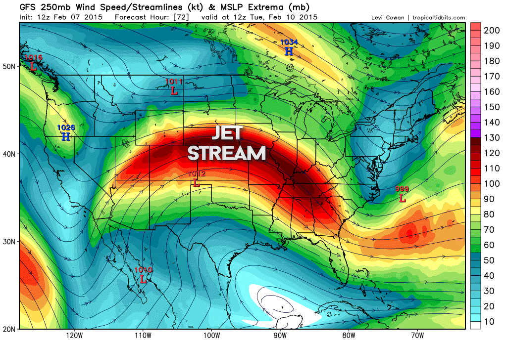
Let me show you the jet stream for the coming 2 weeks. See how it dives down out of the northwest? That is a northwest flow.
This is Tuesday’s jet stream. Northwest flow.
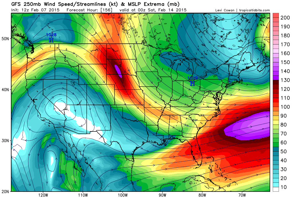
How about next Saturday? Valentines Day? Northwest flow. See the jet diving down out of Canada into our region?
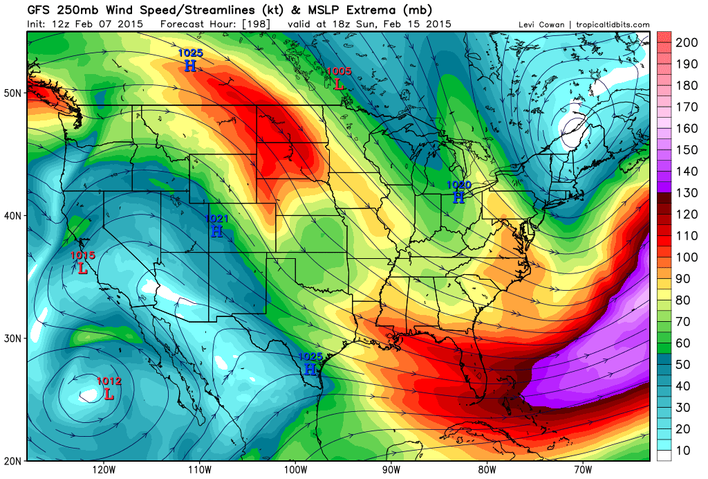
How about Sunday the 15th? Northwest flow.
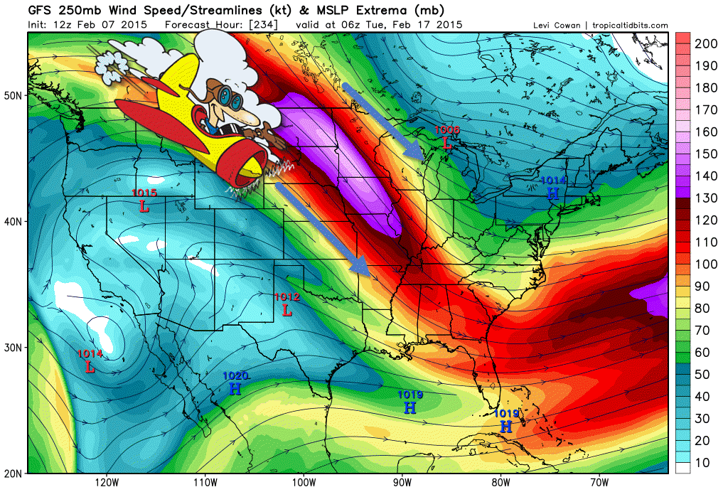
Let’s go further out. Strong jet stream diving out of Canada on the 17th of February. Again – northwest flow. Colder air advancing into our region.
Remember how I told you to look for BIG high pressure coming out of Canada during the winter months? That means cold weather.
Well, here you go. This map is for February 18th (next week). BIG high pressure moving out of Minnesota (if this model is correct). That is a 1045 mb high! Impressive. Whether it is exactly the strength is doubtful, but you get the general idea.
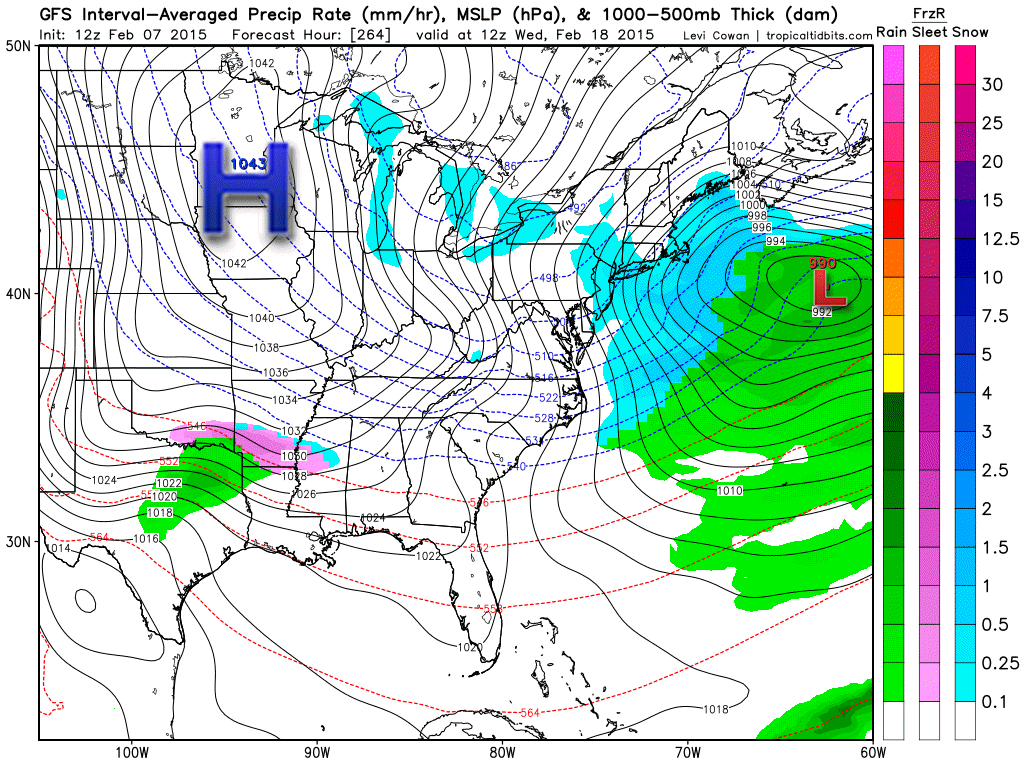
IF that high pressure moves into this region then it would mean more cold air – temperatures at least down into the teens. Whether we can reach single digits is a bit more uncertain. Certainly areas to the north will be in the single digits and even colder.
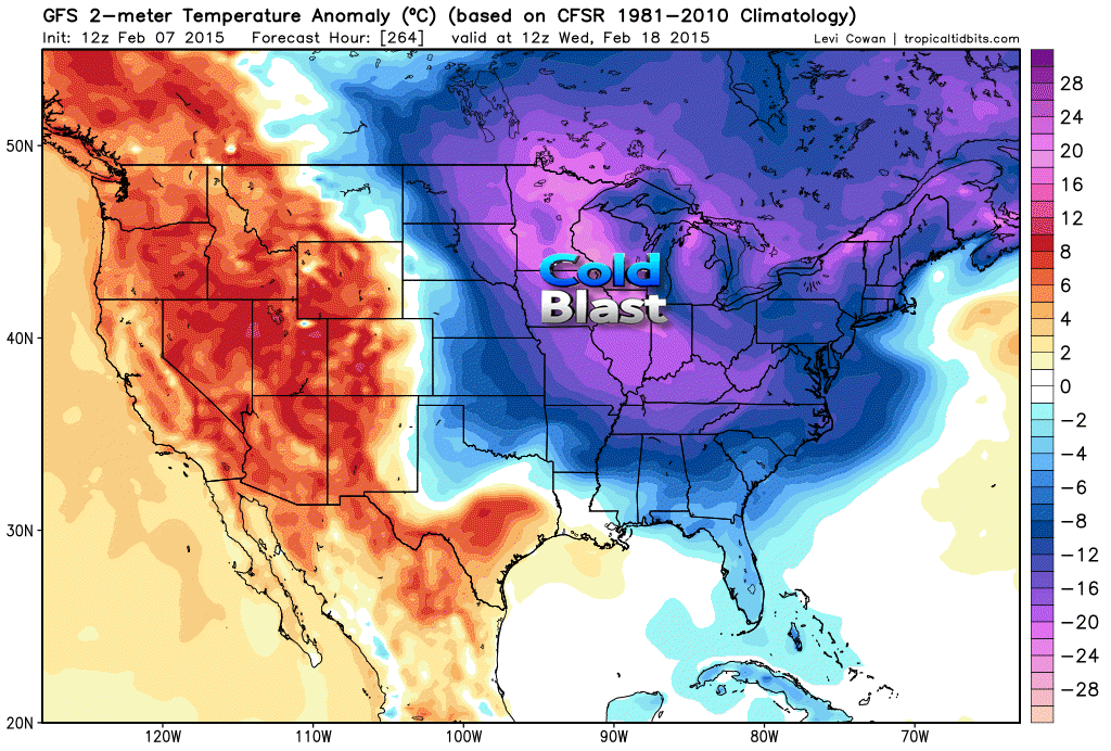
Here are the temperature anomalies for the same time frame. February 18th – check out those departures. Well below normal. Again, if the GFS model is correct then that is an impressive cold blast. If it verifies – again, this is long range forecasting. It’s a gamble.
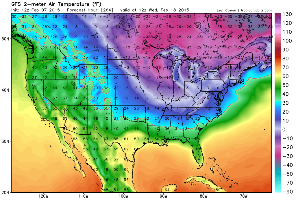
What might actual temperatures look like? Now, will that verify?
I am on-board with the idea of a series of high pressure centers moving southeast out of Canada over the next 2 weeks. And, that means cold air from time to time. This map shows you the possible low temperatures for February 18th (same time as the high pressure moving into the area)
It probably won’t be quite as cold as shown on this map. But, still – looks cold.
The Canadian model does not show the above happening. It is taking the high pressure into southern Canada and the northeast U.S.
If the Canadian model is right then we don’t see a cold blast. There are different model opinions on how all of this plays out. We will keep watching
With all of that said…is there a chance for winter weather in our region? Or, will it rain?
Each cold front will have clouds and perhaps some light rain or snow showers. Not what I call a winter storm. In order to get a decent snow event out of a northwest flow you need an area of low pressure to push southward from Canada. We call these clippers.
There are several clippers coming down, but they will likely be too far northeast of our region to fully impact us. But, we will watch them in case they shift south and west.
A BIGGER question remains – what about a storm system coming out of the southwest United States or a potential merger with a northern storm?
Yes. Some of the data does indicate this happening somewhere between February 15th-20th. Whether it will impact us remains uncertain.
I like the idea of a piece of energy coming out of the southwest. The teleconnections do support this happen. Those involved with the long range cycle see the potential. The EC model has it and the ensembles have it.
Ensembles are model runs – the same model but each run is tweaked just a little bit different from the previous run. The more times the same solution comes up then the more likely it will happen.
I continue to focus on the February 16th-22nd time frame for an event in or near our region. Again, no promises because it is so far out. But, a larger storm may move out of the southwest and northern U.S. – merge and create a bigger precipitation event.
This is what to watch. If you are a winter storm fan then this is the event to focus on. If it happens or not – well, this is the extended range and there are no promises in the extended range.
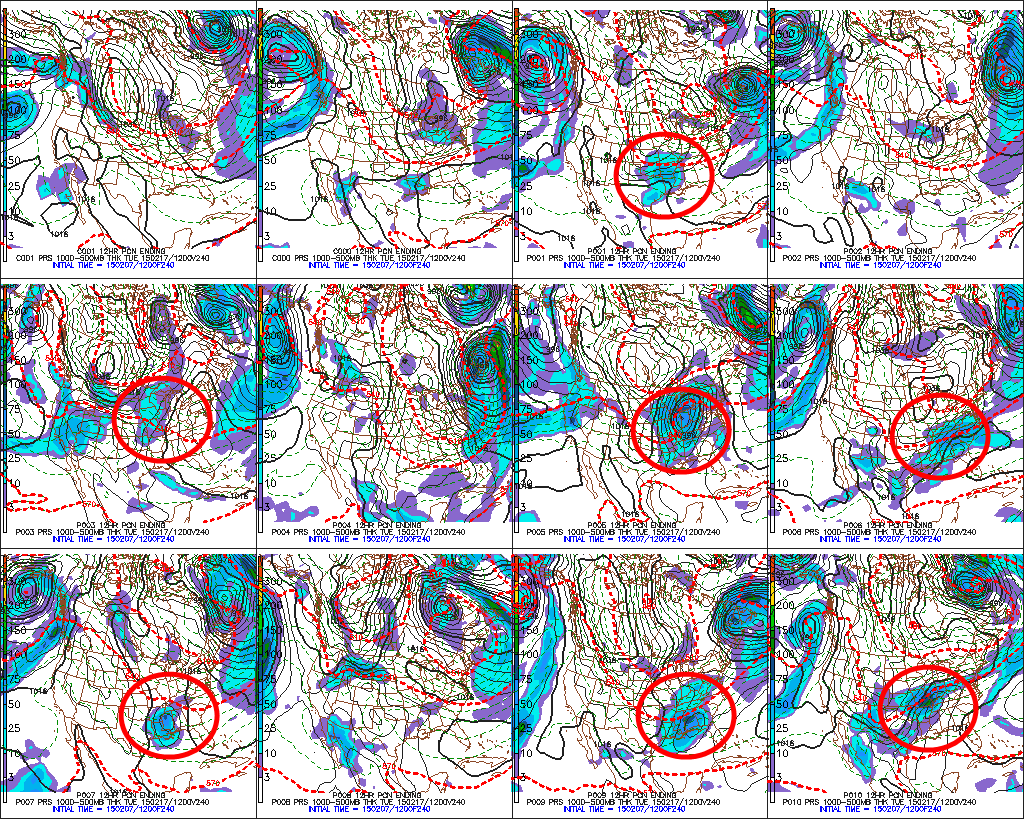
Here are the GFS ensembles. I circled each run that shows the winter storm. A lot of them show this happening. Does not mean it will happen. But, the odds increase the more times it shows up in the data. And, the GFS is not the only model showing this event. The EC has it, as well (as I mentioned above).
Keep in mind that a storm system does not mean snow. It could mean rain, just as well.
Questions that we will have to monitor…
1. Will this thing come out of the southwest at all?
2. Will it come out in one piece
3. Just how far south will this system be off the west coast as it moves into Mexico/southwest
4. Will it go so far south that it misses us entirely
5. Will it be rain or snow or both
Some of the very latest data is starting to show the systems I mentioned on Saturday and Sunday’s update
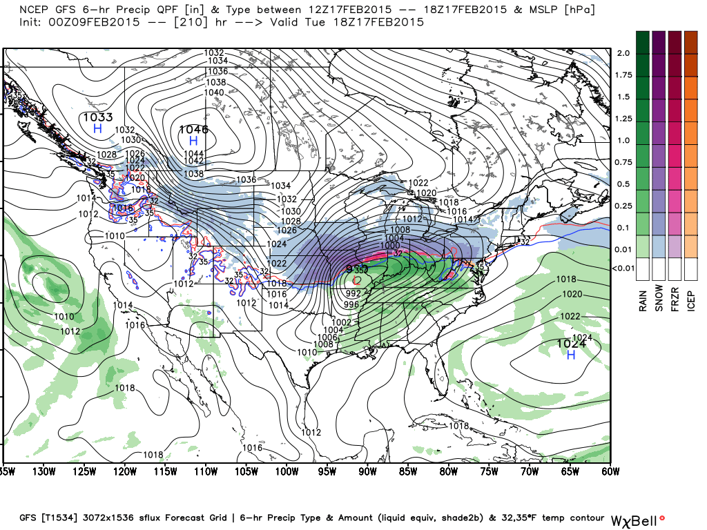
Here is the GFS – showing rain with system one on Monday or Tuesday. The track of the area of low pressure will be key as to whether we end up with snow or rain. Stay tuned.
Here is the Sunday night run of the GFS model. This is the system the week of the 16th. But, what will it actually look like as we move closer to the event? That is the big question. Let’s monitor this each day and see how it changes. I will post updated maps each night. See if the storm sticks.
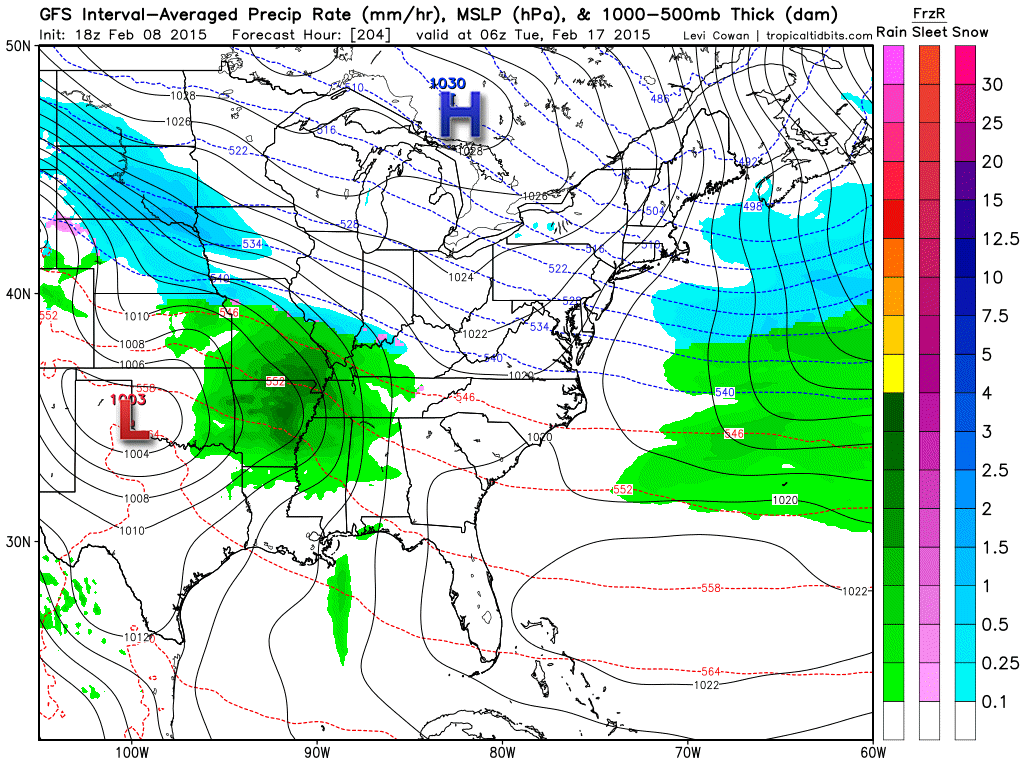
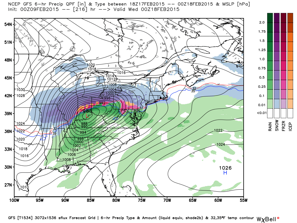
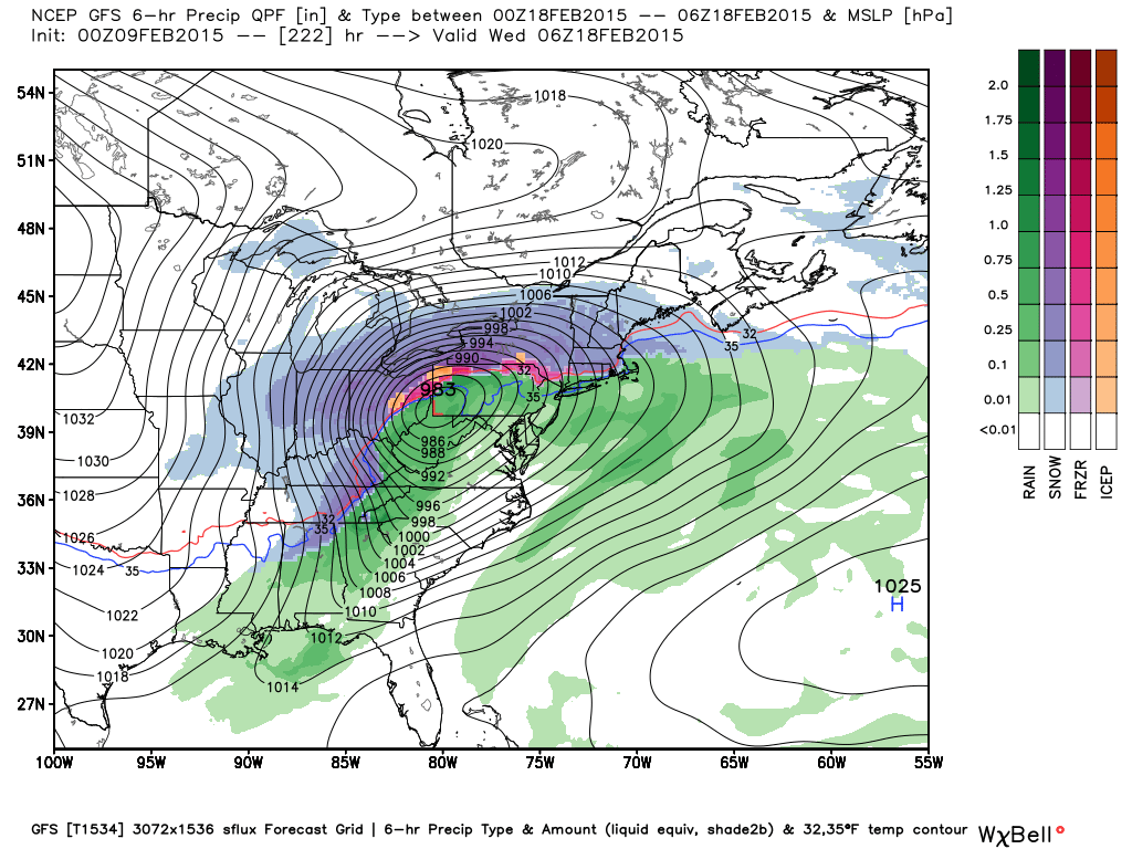
The overnight run of the GFS was one impressive beast for parts of the central U.S. – heavy snow, rain, and thunderstorms.
This is for February 18th and 19th.
The models will jump around on this thing. It will be a wait and see as we move forward. Images from weatherbell.com
A lot of the long range data is starting to show the change of seasons. I am seeing more and more of a battle between cold shots and milder air to the south. Starting to see some better moisture down along the Gulf of Mexico from time to time. Just hints of March approaching.
Something to keep in mind as we start to inch towards Meteorological Spring (March 1st)

Who do you trust for your weather information and who holds them accountable?
I have studied weather in our region since the late 1970’s. I have 37 years of experience in observing our regions weather patterns. My degree is in Broadcast Meteorology from Mississippi State University and an Associate of Science (AS). I am currently working on my Bachelor’s Degree in Geoscience. Just need to finish two Spanish classes!
I am a member of the American Meteorological Society. I am a NOAA Weather-Ready Nation Ambassador. And, I am the Meteorologist for McCracken County Emergency Management.
I own and operate the Southern Illinois Weather Observatory.
There is a lot of noise on the internet. A lot of weather maps are posted without explanation. Over time you should learn who to trust for your weather information.
My forecast philosophy is simple and straight forward.
- Communicate in simple terms
- To be as accurate as possible within a reasonable time frame before an event
- Interact with you on Twitter, Facebook, and the blog
- Minimize the “hype” that you might see on television or through other weather sources
- Push you towards utilizing wall-to-wall LOCAL TV coverage during severe weather events
I am a recipient of the Mark Trail Award, WPSD Six Who Make A Difference Award, Kentucky Colonel, and the Caesar J. Fiamma” Award from the American Red Cross. In 2009 I was presented with the Kentucky Office of Highway Safety Award. I was recognized by the Kentucky House of Representatives for my service to the State of Kentucky leading up to several winter storms and severe weather outbreaks.
If you click on the image below you can read the Kentucky House of Representatives Resolution.

I am also President of the Shadow Angel Foundation which serves portions of western Kentucky and southern Illinois.

We have regional radars and local city radars – if a radar does not seem to be updating then try another one. Occasional browsers need their cache cleared. You may also try restarting your browser. That usually fixes the problem. Occasionally we do have a radar go down. That is why I have duplicates. Thus, if one fails then try another one.
If you have any problems then please send me an email beaudodson@usawx.com
WEATHER RADAR PAGE – Click here —
We also have a new national interactive radar – you can view that radar by clicking here.
Local interactive city radars include St Louis, Mt Vernon, Evansville, Poplar Bluff, Cape Girardeau, Marion, Paducah, Hopkinsville, Memphis, Nashville, Dyersburg, and all of eastern Kentucky – these are interactive radars. Local city radars – click here
NOTE: Occasionally you will see ground clutter on the radar (these are false echoes). Normally they show up close to the radar sites – including Paducah.

Regional Radar – Click on radar to take you our full radar page.


Regional Radar
![]()
Current WARNINGS (a warning means take action now). Click on your county to drill down to the latest warning information. Keep in mind that there can be a 2-3 minute delay in the updated warning information.
I strongly encourage you to use a NOAA Weather Radio or warning cell phone app for the most up to date warning information. Nothing is faster than a NOAA weather radio.


Color shaded counties are under some type of watch, warning, advisory, or special weather statement. Click your county to view the latest information.

Missouri Warnings

Illinois Warnings

Kentucky Warnings

Please visit your local National Weather Service Office by clicking here. The National Weather Service Office, for our region, is located in Paducah, Kentucky. They have a lot of maps and information on their site. Local people…local forecasters who care about our region.


Here is the official 6-10 day and 8-14 day temperature and precipitation outlook. Check the date stamp at the top of each image (so you understand the time frame).
The forecast maps below are issued by the Weather Prediction Center (NOAA).


The latest 8-14 day temperature and precipitation outlook. Note the dates are at the top of the image. These maps DO NOT tell you how high or low temperatures or precipitation will be. They simply give you the probability as to whether temperatures or precipitation will be above or below normal.


Many of my graphics are from www.weatherbell.com – a great resource for weather data, model data, and more


This blog was inspired by ABC 33/40’s Alabama Weather Blog – view their blog
Current tower cam view from the Weather Observatory- Click here for all cameras.

Southern Illinois Weather Observatory

The Weather Observatory

Southern Illinois Weather Observatory
WSIL TV 3 has a number of tower cameras. Click here for their tower camera page & Illinois Road Conditions

Marion, Illinois
WPSD TV 6 has a number of tower cameras. Click here for their tower camera page & Kentucky Road Conditions & Kentucky Highway and Interstate Cameras

Downtown Paducah, Kentucky
Benton, Kentucky Tower Camera – Click here for full view

Benton, Kentucky

I24 Paducah, Kentucky

I24 Mile Point 9 – Paducah, KY

I24 – Mile Point 3 Paducah, Kentucky

You can sign up for my AWARE email by clicking here I typically send out AWARE emails before severe weather, winter storms, or other active weather situations. I do not email watches or warnings. The emails are a basic “heads up” concerning incoming weather conditions.