
Click one of the links below to take you directly to that section
![]()
![]()
![]()
![]()
![]()
![]()
![]()
Do you have any suggestions or comments? Email me at beaudodson@usawx.com
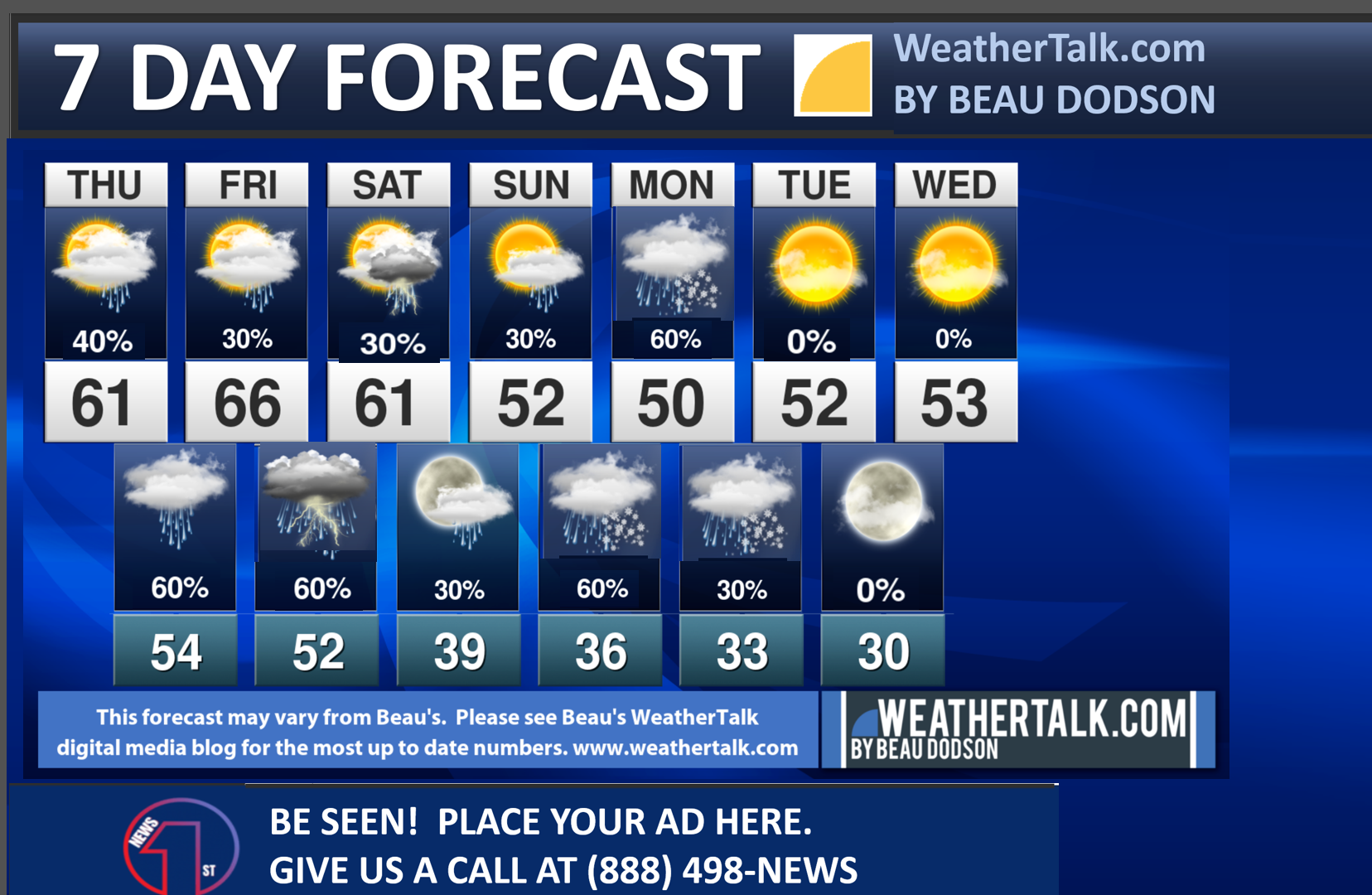
Seven-day forecast for southeast Missouri, southern Illinois, western Kentucky, and western Tennessee.
This is a BLEND for the region. Scroll down to see the region by region forecast.
THE FORECAST IS GOING TO VARY FROM LOCATION TO LOCATION. Scroll down to see the region by region forecast.
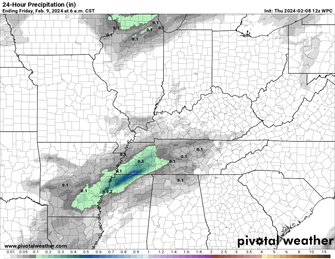
Rain totals through Friday morning.
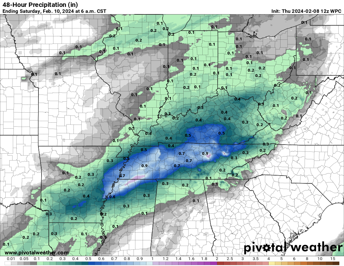
Rain totals through Saturday morning.
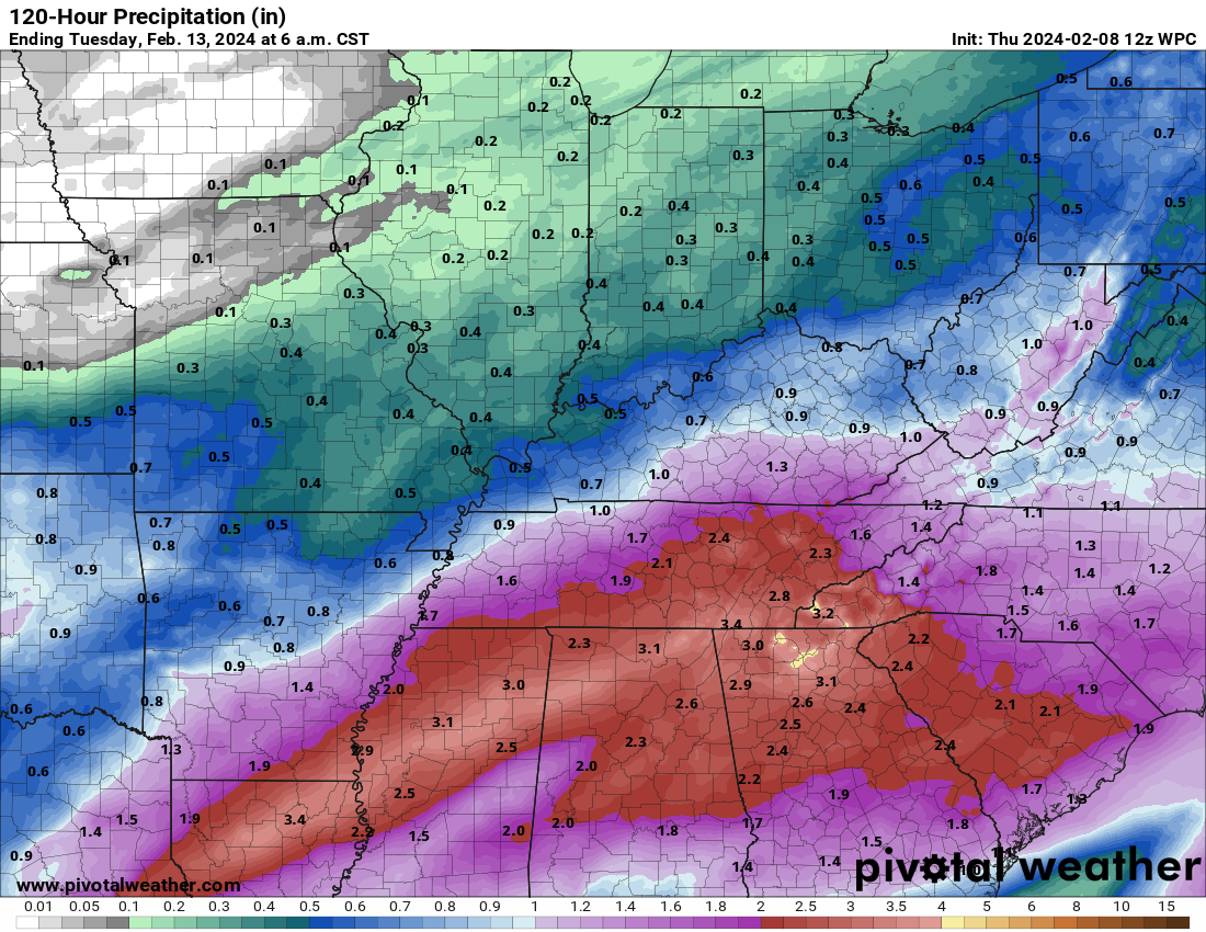
Rain totals through next Tuesday morning.
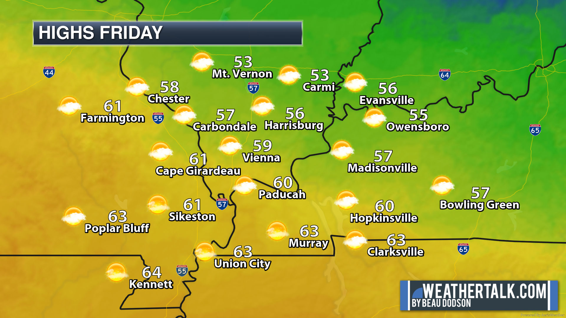
A bit of a range of temperatures today. Cooler northeast. Warmer southwest. This is based on cloud cover.
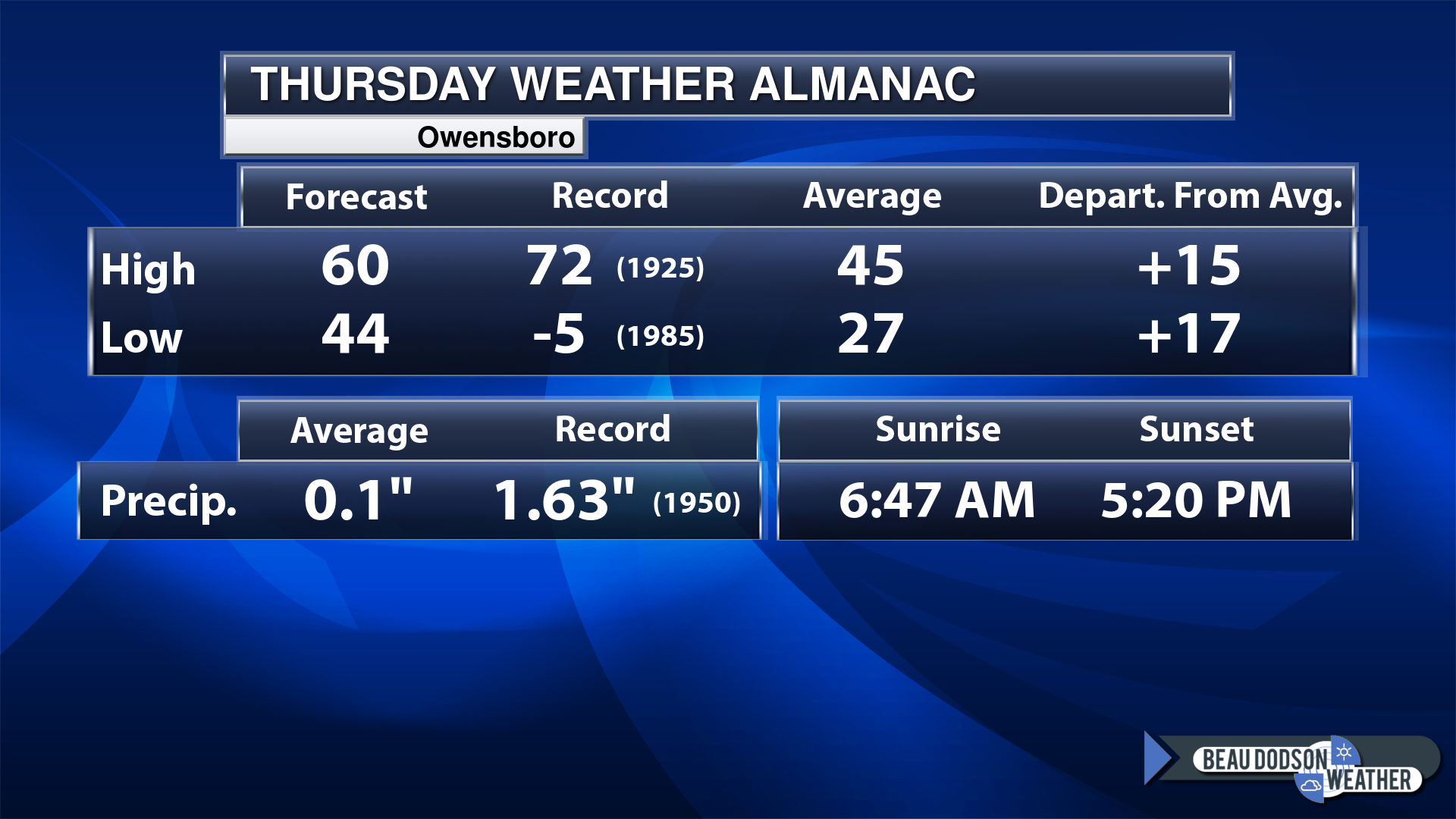
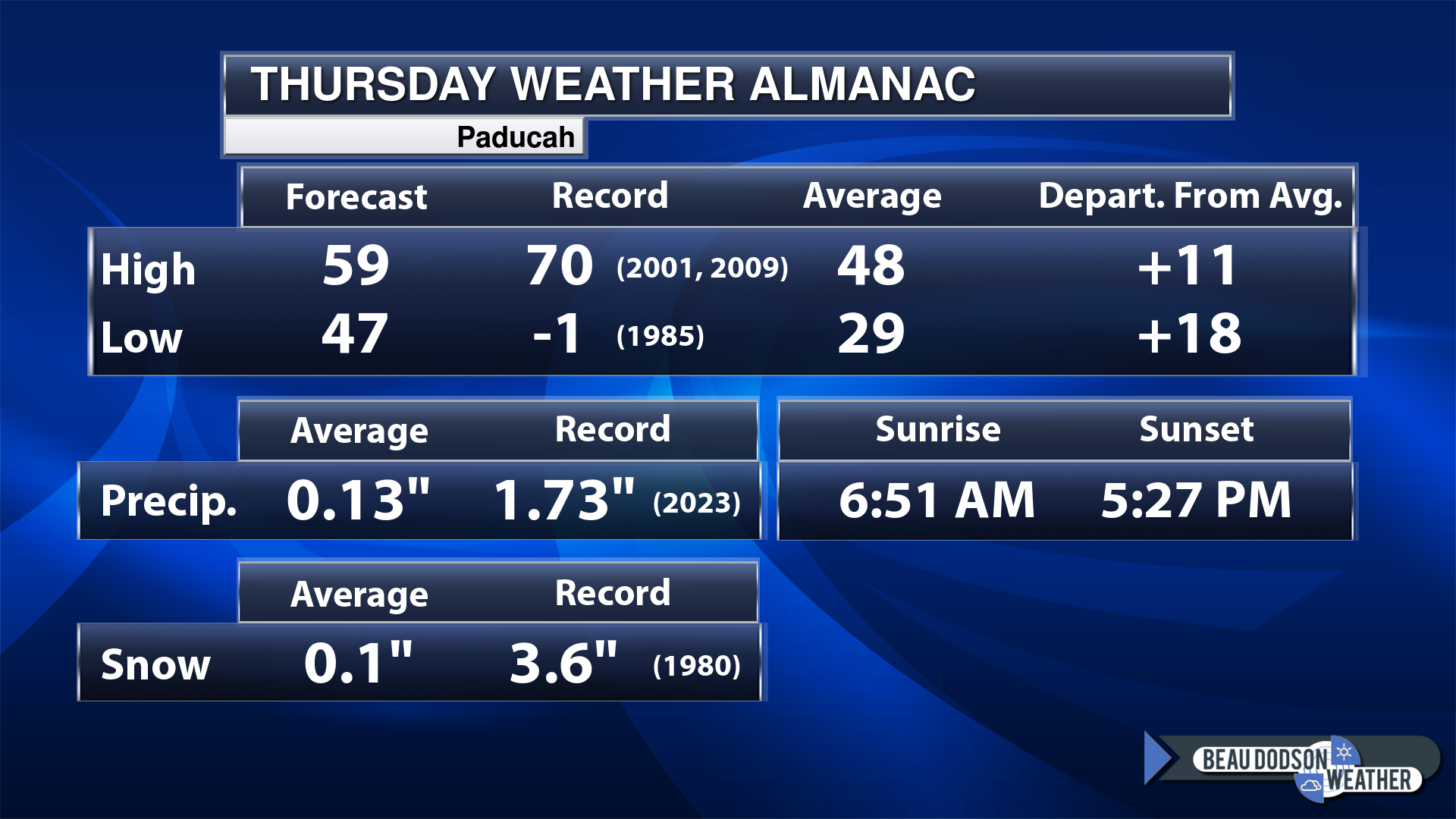
Today’s Local Almanacs (for a few select cities). Your location will be comparable.
Note, the low is this morning’s low and not tomorrows.
Today’s almanac numbers from a few select local cities.
The forecast temperature shows you today’s expected high and this morning’s low.
The graphic shows you the record high and record low for today. It shows you what year that occurred, as well.
It then shows you what today’s average temperature is.
Then, it shows you the departures (how may degrees above or below average temperatures will be ).
It shows you the average precipitation for today. Average comes from thirty years of rain totals.
It also shows you the record rainfall for the date and what year that occurred.
The sunrise and sunset are also shown.


If you have not subscribed to my YouTube Channel then click on this link and it will take you to my videos.
Click the button below and it will take you to the Beau Dodson YouTube Channel.

![]()
48-hour forecast


.

.
Thursday to Thursday
1. Is lightning in the forecast? POSSIBLE. Lightning is possible Thursday PM into Saturday.
2. Are severe thunderstorms in the forecast? MONITOR. I will keep an eye on Friday night. Perhaps one or two stronger storms. For now, the severe weather risk appears limited.
3. Is flash flooding in the forecast? NO.
4. Will the heat index exceed 100 degrees? NO.
5. Will the wind chill dip below 10 degrees? NO.
6. Is measurable snow and/or sleet in the forecast? MONITOR. I am watching Sunday night into Monday night. Another storm system will pass through the region with precipitation. Some of the data shows colder air working its way into the region. That could lead to snow. Low confidence, but I am watching it.
7. Is freezing rain/ice in the forecast? MONITOR. I am watching Sunday night into Monday night. Another storm system will pass through the region with rain or a wintry mix. It is too early to know precipitation type. For now, I have rain and a rain/snow mix.
Freezing rain is rain that falls and instantly freezes on objects such as trees and power lines Freezing fog possible, as well.
.
Fire weather risk level.
Thursday: 5. Moderate risk.
Thursday night. 4. Low risk.
Friday through Friday night: 5. Moderate risk.
Fire Weather Discussion
Gusty south winds will bring increased humidity to the region today. However, Ft Campbell and Greenville Kentucky may see relative humidity dip down to 40 percent this afternoon. Humid and breezy conditions will continue Friday and then a decent shot at a wetting rain is forecast Friday night into Saturday, when a few thunderstorms will be possible. A cold front early Saturday will bring an end to the rain except possibly near the Tennessee border in west Kentucky. A strong storm system will bring more rain to the region Sunday into Monday. Dry conditions return Tuesday.
A Haines Index of 6 means a high potential for an existing fire to become large or exhibit erratic fire behavior, 5 means medium potential, 4 means low potential, and anything less than 4 means very low potential.
.

.
Thursday, February 08, 2024
Confidence in the forecast? High Confidence
Thursday Forecast: Intervals of clouds. A chance of scattered showers. Especially over southeast Missouri and southern Illinois. Lower chances southeast of there.
What is the chance of precipitation?
Far northern southeast Missouri ~ 30%
Southeast Missouri ~ 30%
The Missouri Bootheel ~ 30%
I-64 Corridor of southern Illinois ~ 20%
Southern Illinois ~ 30%
Extreme southern Illinois (southern seven counties) ~ 30%
Far western Kentucky (Purchase area) ~ 30%
The Pennyrile area of western KY ~ 10%
Northwest Kentucky (near Indiana border) ~ 10%
Northwest Tennessee ~ 30%
Coverage of precipitation: Scattered
Timing of the precipitation: Mainly late morning into afternoon
Far northern southeast Missouri ~ 60° to 64°
Southeast Missouri ~ 60° to 64°
The Missouri Bootheel ~ 60° to 64°
I-64 Corridor of southern Illinois ~ 60° to 64°
Southern Illinois ~ 60° to 64°
Extreme southern Illinois (southern seven counties) ~ 60° to 64°
Far western Kentucky ~ 60° to 64°
The Pennyrile area of western KY ~ 60° to 64°
Northwest Kentucky (near Indiana border) ~ 60° to 64°
Northwest Tennessee ~ 60° to 64°
Winds will be from this direction: South 15 to 35 mph. Gusty.
Wind chill or heat index (feels like) temperature forecast: 60° to 64°
What impacts are anticipated from the weather? Wet roadways.
Should I cancel my outdoor plans? No, but monitor updates.
UV Index: 3. Moderate.
Sunrise: 6:52 AM
Sunset: 5:27 PM .
.
Thursday Night Forecast: Cloudy. A chance of rain. A thunderstorm will be possible. Breezy and mild. Most of the precipitation will remain over the Missouri Bootheel into Kentucky and Tennessee.
What is the chance of precipitation?
Far northern southeast Missouri ~ 20%
Southeast Missouri ~ 30%
The Missouri Bootheel ~ 40%
I-64 Corridor of southern Illinois ~ 20%
Southern Illinois ~ 20%
Extreme southern Illinois (southern seven counties) ~ 30%
Far western Kentucky (Purchase area) ~ 40%
The Pennyrile area of western KY ~ 60%
Northwest Kentucky (near Indiana border) ~ 40%
Northwest Tennessee ~ 60%
Coverage of precipitation: Scattered (mainly over KY/TN)
Timing of the precipitation: Any given point of time
Temperature range:
Far northern southeast Missouri 50° to 54°
Southeast Missouri ~ 52° to 54°
The Missouri Bootheel ~ 53° to 56°
I-64 Corridor of southern Illinois ~ 52° to 54°
Southern Illinois ~ 52° to 54°
Extreme southern Illinois (southern seven counties) ~ 52° to 54°
Far western Kentucky ~ 52° to 54°
The Pennyrile area of western KY ~ 52° to 54°
Northwest Kentucky (near Indiana border) ~ 52° to 54°
Northwest Tennessee ~ 53° to 56°
Winds will be from this direction: South 15 to 30 mph.
Wind chill or heat index (feels like) temperature forecast: 48° to 52°
What impacts are anticipated from the weather? Wet roadways. Lightning.
Should I cancel my outdoor plans? No, but monitor the Beau Dodson Weather Radars.
Moonrise: 6:17 AM
Moonset: 3:56 PM
The phase of the moon: Waning Crescent
.
Friday, February 09, 2024
Confidence in the forecast? High Confidence
Friday Forecast: Partly cloudy. Warm and breezy. A slight chance of afternoon showers and thunderstorms. Mainly our far southeast counties.
What is the chance of precipitation?
Far northern southeast Missouri ~ 10%
Southeast Missouri ~ 20%
The Missouri Bootheel ~ 20%
I-64 Corridor of southern Illinois ~ 10%
Southern Illinois ~ 20%
Extreme southern Illinois (southern seven counties) ~ 20%
Far western Kentucky (Purchase area) ~ 30%
The Pennyrile area of western KY ~ 40%
Northwest Kentucky (near Indiana border) ~ 30%
Northwest Tennessee ~ 30%
Coverage of precipitation: Scattered
Timing of the precipitation: Any given point of time.
Far northern southeast Missouri ~ 66° to 68°
Southeast Missouri ~ 66° to 68°
The Missouri Bootheel ~ 66° to 68°
I-64 Corridor of southern Illinois ~ 66° to 68°
Southern Illinois ~ 66° to 68°
Extreme southern Illinois (southern seven counties) ~ 66° to 68°
Far western Kentucky ~ 66° to 68°
The Pennyrile area of western KY ~ 66° to 68°
Northwest Kentucky (near Indiana border 66° to 68°
Winds will be from this direction: Southwest 10 to 25 mph. Gusty. Becoming west southwest.
Wind chill or heat index (feels like) temperature forecast: 62° to 68°
What impacts are anticipated from the weather? Wet roadways. Lightning.
Should I cancel my outdoor plans? No, but check the Beau Dodson Weather Radars.
UV Index: 2. Low.
Sunrise: 6:51 AM
Sunset: 5:28 PM .
.
Friday Night Forecast: Mostly cloudy. Rain likely. An embedded thunderstorm will be possible.
What is the chance of precipitation?
Far northern southeast Missouri ~ 40%
Southeast Missouri ~ 40%
The Missouri Bootheel ~ 60%
I-64 Corridor of southern Illinois ~ 40%
Southern Illinois ~ 40%
Extreme southern Illinois (southern seven counties) ~ 60%
Far western Kentucky (Purchase area) ~ 70%
The Pennyrile area of western KY ~ 80%
Northwest Kentucky (near Indiana border) ~ 60%
Northwest Tennessee ~ 80%
Coverage of precipitation: Numerous
Timing of the precipitation: Any given point of time.
Temperature range:
Far northern southeast Missouri 46° to 48°
Southeast Missouri ~ 44° to 46°
The Missouri Bootheel ~ 48° to 50°
I-64 Corridor of southern Illinois ~ 44° to 46°
Southern Illinois ~ 44° to 46°
Extreme southern Illinois (southern seven counties) ~ 48° to 50°
Far western Kentucky ~ 50° to 52°
The Pennyrile area of western KY ~ 55° to 60°
Northwest Kentucky (near Indiana border) ~ 50° to 52°
Northwest Tennessee ~ 52° to 55°
Winds will be from this direction: South southwest 15 to 30 mph.
Wind chill or heat index (feels like) temperature forecast: 42° to 54°
What impacts are anticipated from the weather? Wet roadways. Lightning.
Should I cancel my outdoor plans? Have a plan B and monitor the Beau Dodson Weather Radars.
Moonrise: 7:00 AM
Moonset: 5:16 PM
The phase of the moon: New
.
Saturday, February 10, 2024
Confidence in the forecast? High Confidence
Saturday Forecast: Partly sunny. Mild. A chance of showers and thunderstorms. Chances will be higher southeast vs northwest.
What is the chance of precipitation?
Far northern southeast Missouri ~ 20%
Southeast Missouri ~ 20%
The Missouri Bootheel ~ 30%
I-64 Corridor of southern Illinois ~ 20%
Southern Illinois ~ 20%
Extreme southern Illinois (southern seven counties) ~ 20%
Far western Kentucky (Purchase area) ~ 40%
The Pennyrile area of western KY ~ 60%
Northwest Kentucky (near Indiana border) ~ 40%
Northwest Tennessee ~ 40%
Coverage of precipitation: Scattered. More southeast vs northwest.
Timing of the precipitation: Any given point of time.
Far northern southeast Missouri ~ 54° to 58°
Southeast Missouri ~ 58° to 62°
The Missouri Bootheel ~ 60° to 62°
I-64 Corridor of southern Illinois ~ 54° to 58°
Southern Illinois ~ 56° to 60°
Extreme southern Illinois (southern seven counties) ~ 58° to 62°
Far western Kentucky ~ 58° to 62°
The Pennyrile area of western KY ~ 62° to 65°
Northwest Kentucky (near Indiana border 62° to 65°
Winds will be from this direction: North northwest 8 to 16 mph over southeast Missouri and southern Illinois. South southwest over Kentucky and Tennessee. There will be a front dividing the area.
Wind chill or heat index (feels like) temperature forecast: 56° to 60°
What impacts are anticipated from the weather? Wet roadways.
Should I cancel my outdoor plans? No, but monitor the Beau Dodson Weather Radars
UV Index: 2. Low.
Sunrise: 6:50 AM
Sunset: 5:29 PM .
.
Saturday Night Forecast: Mostly cloudy. A chance of showers. Perhaps a thunderstorm. The rain chances will again be higher near the stalled front. That would be our eastern and southeastern counties.
What is the chance of precipitation?
Far northern southeast Missouri ~ 10%
Southeast Missouri ~ 20%
The Missouri Bootheel ~ 40%
I-64 Corridor of southern Illinois ~ 10%
Southern Illinois ~ 20%
Extreme southern Illinois (southern seven counties) ~ 30%
Far western Kentucky (Purchase area) ~ 40%
The Pennyrile area of western KY ~ 40%
Northwest Kentucky (near Indiana border) ~ 60%
Northwest Tennessee ~ 60%
Coverage of precipitation: Scattered
Timing of the precipitation: Any given point of time.
Temperature range:
Far northern southeast Missouri 32° to 34°
Southeast Missouri ~ 33° to 36°
The Missouri Bootheel ~ 38° to 42°
I-64 Corridor of southern Illinois ~ 33° to 36°
Southern Illinois ~ 34° to 36°
Extreme southern Illinois (southern seven counties) ~ 38° to 42°
Far western Kentucky ~ 40° to 44°
The Pennyrile area of western KY ~ 42° to 45°
Northwest Kentucky (near Indiana border) ~ 40° to 44°
Northwest Tennessee ~ 40° to 44°
Winds will be from this direction: Northeast 7 to 14 mph
Wind chill or heat index (feels like) temperature forecast: 28° to 38°
What impacts are anticipated from the weather? Wet roadways.
Should I cancel my outdoor plans? No, but monitor the Beau Dodson Weather Radars.
Moonrise: 7:36 AM
Moonset: 6:34 PM
The phase of the moon: Waxing Crescent
.
Sunday, February 11, 2024
Confidence in the forecast? High Confidence
Sunday Forecast: A mix of sun and clouds. A chance of showers.
What is the chance of precipitation?
Far northern southeast Missouri ~ 30%
Southeast Missouri ~ 30%
The Missouri Bootheel ~ 30%
I-64 Corridor of southern Illinois ~ 30%
Southern Illinois ~ 30%
Extreme southern Illinois (southern seven counties) ~ 30%
Far western Kentucky (Purchase area) ~ 30%
The Pennyrile area of western KY ~ 30%
Northwest Kentucky (near Indiana border) ~ 30%
Northwest Tennessee ~ 30%
Coverage of precipitation: Scattered
Timing of the precipitation: Any given point of time.
Far northern southeast Missouri ~ 46° to 48°
Southeast Missouri ~ 46° to 48°
The Missouri Bootheel ~ 50° to 62°
I-64 Corridor of southern Illinois ~ 46° to 50°
Southern Illinois ~ 48° to 52°
Extreme southern Illinois (southern seven counties) ~ 50° to 55°
Far western Kentucky ~ 52° to 55°
The Pennyrile area of western KY ~ 54° to 58°
Northwest Kentucky (near Indiana border 50° to 52°
Winds will be from this direction: North northeast 10 to 20 mph
Wind chill or heat index (feels like) temperature forecast: 56° to 60°
What impacts are anticipated from the weather? Wet roadways.
Should I cancel my outdoor plans? No, but monitor the Beau Dodson Weather Radars
UV Index: 3. Moderate.
Sunrise: 6:48 AM
Sunset: 5:30 PM .
.
Sunday Night Forecast: Cloudy. Rain likely. I will need to monitor temperatures. I can’t rule out rain/snow over portions of the region. Especially Missouri/Illinois.
What is the chance of precipitation?
Far northern southeast Missouri ~ 60%
Southeast Missouri ~ 60%
The Missouri Bootheel ~ 60%
I-64 Corridor of southern Illinois ~ 60%
Southern Illinois ~ 60%
Extreme southern Illinois (southern seven counties) ~ 60%
Far western Kentucky (Purchase area) ~ 60%
The Pennyrile area of western KY ~ 60%
Northwest Kentucky (near Indiana border) ~ 60%
Northwest Tennessee ~ 60%
Coverage of precipitation: Numerous
Timing of the precipitation: Any given point of time.
Temperature range:
Far northern southeast Missouri 32° to 34°
Southeast Missouri ~ 33° to 36°
The Missouri Bootheel ~ 38° to 42°
I-64 Corridor of southern Illinois ~ 32° to 34°
Southern Illinois ~ 34° to 36°
Extreme southern Illinois (southern seven counties) ~ 38° to 42°
Far western Kentucky ~ 40° to 42°
The Pennyrile area of western KY ~ 42° to 44°
Northwest Kentucky (near Indiana border) ~ 40° to 44°
Northwest Tennessee ~ 40° to 44°
Winds will be from this direction: Northeast 10 to 25 mph
Wind chill or heat index (feels like) temperature forecast: 28° to 38°
What impacts are anticipated from the weather? Wet roadways. Monitor updates on snow.
Should I cancel my outdoor plans? Have a plan B and monitor the Beau Dodson Weather Radars
Moonrise: 8:08 AM
Moonset: 7:49 PM
The phase of the moon: Waxing Crescent
.
Monday, February 12, 2024
Confidence in the forecast? High Confidence
Monday Forecast: Cloudy. A chance of rain. Perhaps rain/snow if temperatures are a bit colder (esp MO/IL)
What is the chance of precipitation?
Far northern southeast Missouri ~ 60%
Southeast Missouri ~ 60%
The Missouri Bootheel ~ 60%
I-64 Corridor of southern Illinois ~ 60%
Southern Illinois ~ 60%
Extreme southern Illinois (southern seven counties) ~ 60%
Far western Kentucky (Purchase area) ~ 60%
The Pennyrile area of western KY ~ 60%
Northwest Kentucky (near Indiana border) ~ 60%
Northwest Tennessee ~ 60%
Coverage of precipitation: Numerous
Timing of the precipitation: Any given point of time.
Far northern southeast Missouri ~ 36° to 40°
Southeast Missouri ~ 38° to 40°
The Missouri Bootheel ~ 40° to 42°
I-64 Corridor of southern Illinois ~ 36° to 40°
Southern Illinois ~ 38° to 42°
Extreme southern Illinois (southern seven counties) ~ 40° to 42°
Far western Kentucky ~ 42° to 45°
The Pennyrile area of western KY ~ 44° to 48°
Northwest Kentucky (near Indiana border 42° to 44°
Winds will be from this direction: Northwest 10 to 20 mph. Gusty.
Wind chill or heat index (feels like) temperature forecast: 28° to 44°
What impacts are anticipated from the weather? Wet roadways. Monitor updates on snow.
Should I cancel my outdoor plans? Have a plan B and monitor the Beau Dodson Weather Radars.
UV Index: 2. Low.
Sunrise: 6:47 AM
Sunset: 5:31 PM .
.
Monday Night Forecast: Mostly cloudy. A chance of rain or rain/snow showers.
What is the chance of precipitation?
Far northern southeast Missouri ~ 40%
Southeast Missouri ~ 40%
The Missouri Bootheel ~ 40%
I-64 Corridor of southern Illinois ~ 40%
Southern Illinois ~ 40%
Extreme southern Illinois (southern seven counties) ~ 40%
Far western Kentucky (Purchase area) ~ 40%
The Pennyrile area of western KY ~ 60%
Northwest Kentucky (near Indiana border) ~ 60%
Northwest Tennessee ~ 40%
Coverage of precipitation: Scattered
Timing of the precipitation: Mainly before midnight.
Temperature range:
Far northern southeast Missouri 24° to 28°
Southeast Missouri ~ 24° to 28°
The Missouri Bootheel ~ 28° to 32°
I-64 Corridor of southern Illinois ~ 24° to 28°
Southern Illinois ~ 26° to 28°
Extreme southern Illinois (southern seven counties) ~ 28° to 30°
Far western Kentucky ~ 28° to 32°
The Pennyrile area of western KY ~ 32° to 35°
Northwest Kentucky (near Indiana border) ~ 30° to 34°
Northwest Tennessee ~ 32° to 34°
Winds will be from this direction: Northwest 10 to 20 mph.
Wind chill or heat index (feels like) temperature forecast: 22° to 30°
What impacts are anticipated from the weather? Wet roadways. Monitor updates on snow.
Should I cancel my outdoor plans? Have a plan B and monitor the Beau Dodson Weather Radars
Moonrise: 8:34 AM
Moonset: 9:01 PM
The phase of the moon: Waxing Crescent
.
Click here if you would like to return to the top of the page.

-
- Well above average temperatures.
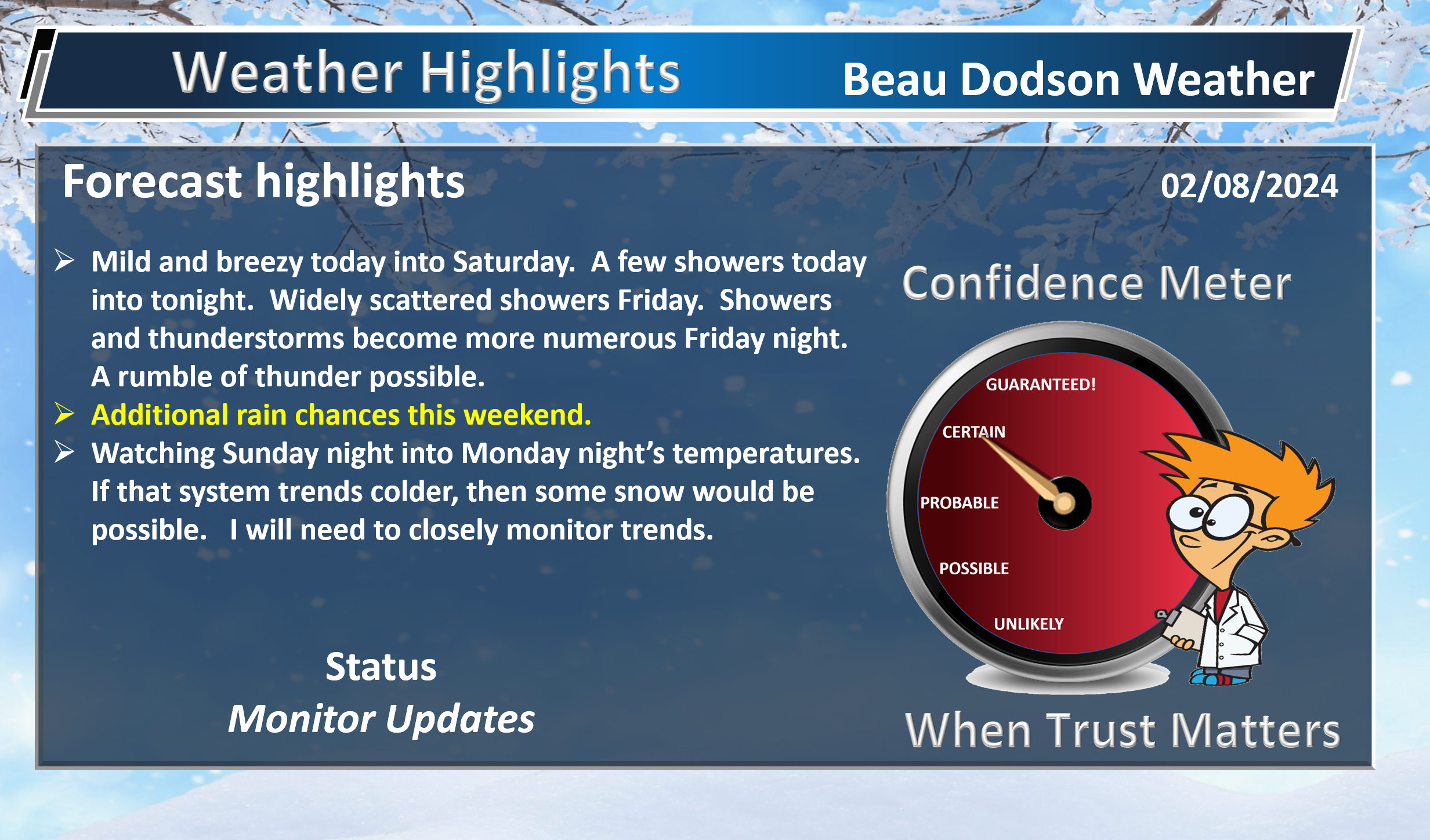
- Cold front arrives Thursday PM into the weekend with showers and perhaps a few embedded thunderstorms.
- Rain totals have been lowered for Thursday night. Mostly in the 0.01″ to 0.15″ range. Higher totals are now possible Friday into the weekend.
- A tricky forecast for Monday and Tuesday. We will need to monitor temperatures. If it were a tad colder, then snow would be possible.
- I continue to watch mid to late February into March for several cold shots.
Weather advice:
Make sure you have three to five ways of receiving your severe weather information.
Forecast Discussion
Another calm day of weather for the region. Today will be mild and windy. Winds could gust above 35 mph over southeast Missouri and southern Illinois. Gusts above 20 mph everywhere else.
Clouds will be streaming into the area from the southwest moving northeast. A few showers will be possible, as well. The chance of showers is a bit higher over southeast Missouri and southern Illinois.
Rain chances have diminished tonight. We still expect a few showers. Perhaps an isolated lightning strike. Rain totals will be less than 0.10″.
Friday will be warm and windy. A few showers will be possible. Perhaps a thunderstorm. Chances will be higher from the Bootheel into Kentucky and Tennessee.
Rain chances ramp up area-wide Friday night into early Saturday morning. Rain totals will be higher with that round of precipitation. See the graphics at the top of the page.
A few strong thunderstorms will also be possible Friday night. There isn’t a lot of CAPE. CAPE is energy that storms tap into. There will, however, be some. Enough for lightning and perhaps enough to bring down some gusty winds.
At this time, severe weather appears unlikely. But, I will need to monitor it. Worse case, a marginal risk would be issues. That is a level one risk. The lowest risk.
A few showers will continue into Saturday night and Sunday.
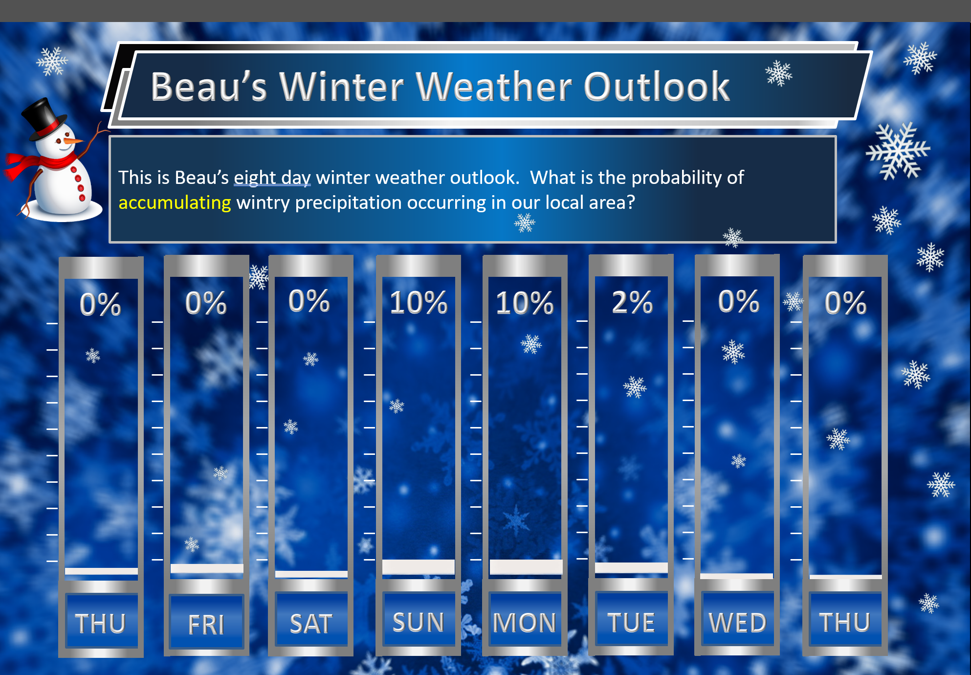
Precipitation chances ramp up Sunday night into Monday night. Temperatures may be cold enough for a burst of snow. Slushy accumulation would be possible.
Confidence in snow is low. Quite a few ensembles show snow. Quite a bit of data shows snow. A thin band of snow on the northwest side of the area of low pressure.
Whether there will be accumulation is the question. Road and land surfaces will be warm, because of today, tomorrow, and Saturday’s highs. Perhaps the roads will be too warm for impacts. As always, bridges and overpasses freeze first. Keep that in mind.
I will need to fine tune the Sunday night into Monday night portion of the forecast.
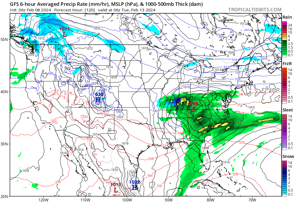
Let me show you some graphics.
The GFS model. Monday night. It shows snow in blue. Green is rain. You can see a little blue in there.
I will just need to monitor trends.
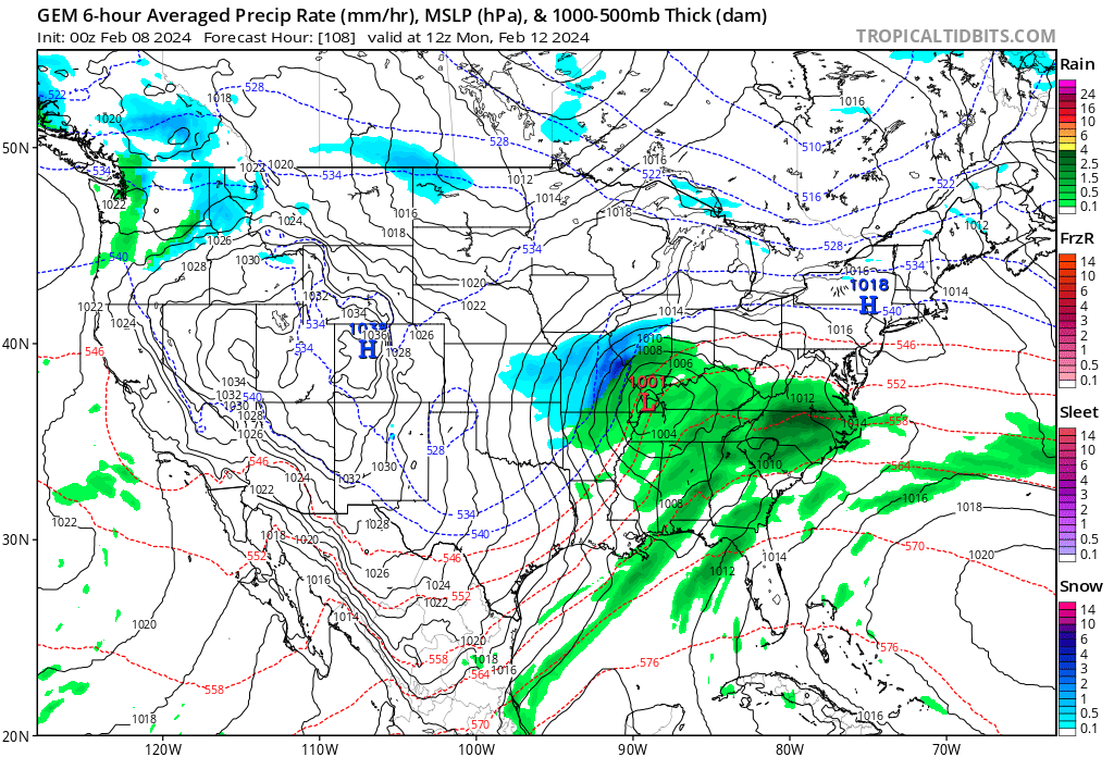
Click images to enlarge them.
The Canadian model. Monday morning. This model shows the snow farther north northwest.
The EC model. Monday morning. Blue is snow. Purple is a mix. Green is rain.
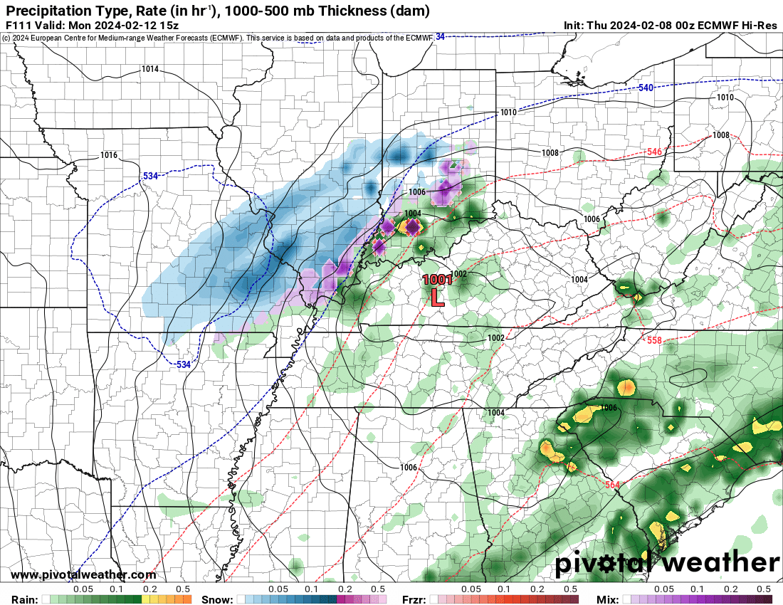
Those are static shots showing what the weather map might look like.
I continue to watch a few cold shots mid to late February into March.
I continue to raise questions about how cold. I know there are quite a few forecasts floating around calling for a return of the polar vortex with bitterly cold air. I still am not confident that happens.
Not saying it is impossible, but I am going to need more data to forecasts bitterly cold air. If we were to have a decent snow event, then the chance of bitterly cold air would increase. Let’s keep an eye on that portion of the forecast.
I am confident we will have cold shots. That would be fairly normal for February and March. I am just not sure we return to January type cold. Again, I know there are forecasts saying that.
Confidence in that isn’t great.
As I have mentioned numerous times, just because we have cold shots of air does not mean we will have snow or a wintry mix. You can have all the cold air in the world, but if you don’t have precipitation, then it doesn’t matter. You just end up cold.
Each precipitation system is a roll of the dice.
If we have cold in place, then we watch for an active storm track. A stormy pattern. If you have the cold air AND a stormy pattern, then you watch for snow or a wintry mix. The more storm systems, the higher the chances that one of those will produce wintry precipitation.
We are running out of time for winter storms. We still have several more weeks of winter. Once we move into the 2nd week of March, the chances for snow decrease. Once we move into the third and fourth week of March, the chances rapidly decrease.
That leaves us the rest of February into the first week or so of March.
![]()
.
Click here if you would like to return to the top of the page.
This outlook covers southeast Missouri, southern Illinois, western Kentucky, and far northwest Tennessee.

.
Today’s Storm Prediction Center’s Severe Weather Outlook
Light green is where thunderstorms may occur but should be below severe levels.
Dark green is a level one risk. Yellow is a level two risk. Orange is a level three (enhanced) risk. Red is a level four (moderate) risk. Pink is a level five (high) risk.
One is the lowest risk. Five is the highest risk.
A severe storm is one that produces 58 mph wind or higher, quarter size hail, and/or a tornado.
Explanation of tables. Click here.

.
Tornado Probability Outlook

.
Large Hail Probability Outlook

.
High wind Probability Outlook

.
Tomorrow’s severe weather outlook.

.
Day Three Severe Weather Outlook

.

.
The images below are from NOAA’s Weather Prediction Center.
24-hour precipitation outlook..
 .
.
.
48-hour precipitation outlook.
. .
.
![]()
_______________________________________
.

Click here if you would like to return to the top of the page.
Again, as a reminder, these are models. They are never 100% accurate. Take the general idea from them.
What should I take from these?
- The general idea and not specifics. Models usually do well with the generalities.
- The time-stamp is located in the upper left corner.
.
What am I looking at?
You are looking at computer model data. Meteorologists use many different models to forecast the weather.
Occasionally, these maps are in Zulu time. 12z=7 AM. 18z=1 PM. 00z=7 PM. 06z=1 AM
Green represents light rain. Dark green represents moderate rain. Yellow and orange represent heavier rain.
.
This animation is the HRRR Model.
Occasionally, these maps are in Zulu time. 12z=6 AM. 18z=12 PM. 00z=6 PM. 06z=12 AM
Double click images to enlarge them. Blue is snow. Pink is a wintry mix. Green is rain.
.
This animation is the NAM 3K Model.
Occasionally, these maps are in Zulu time. 12z=6 AM. 18z=12 PM. 00z=6 PM. 06z=12 AM
Double click images to enlarge them.
.
This animation is the GFS Model.
Green is rain. Yellow and orange are heavier rain. Pink is a wintry mix. Blue is snow. Dark blue is heavier snow.
Occasionally, these maps are in Zulu time. 12z=6 AM. 18z=12 PM. 00z=6 PM. 06z=12 AM
Double click images to enlarge them.
.
This animation is the EC Model.
Green is rain. Yellow and orange are heavier rain. Pink is a wintry mix. Blue is snow. Dark blue is heavier snow.
Occasionally, these maps are in Zulu time. 12z=6 AM. 18z=12 PM. 00z=6 PM. 06z=12 AM
Double click images to enlarge them.
..![]()

.
Click here if you would like to return to the top of the page.
.Average high temperatures for this time of the year are around 46 degrees.
Average low temperatures for this time of the year are around 28 degrees.
Average precipitation during this time period ranges from 0.50″ to 1.00″
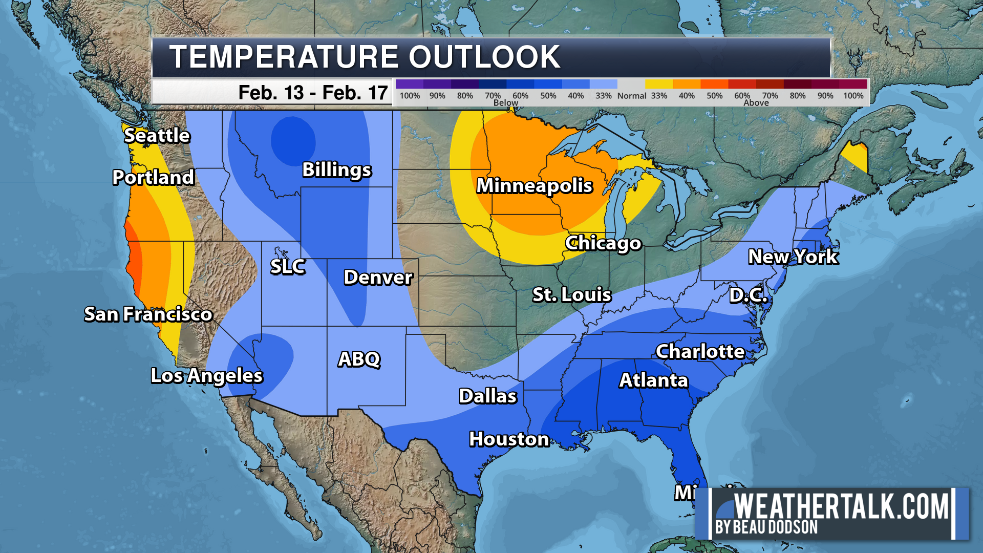
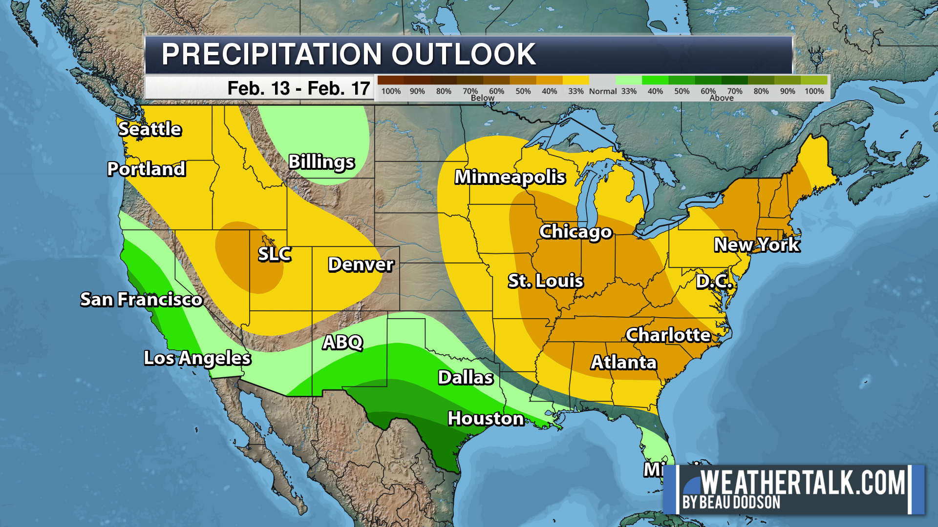
Six to Ten Day Outlook.
Blue is below average. Red is above average. The no color zone represents equal chances.
Average highs for this time of the year are in the lower 60s. Average lows for this time of the year are in the lower 40s.
Green is above average precipitation. Yellow and brown favors below average precipitation. Average precipitation for this time of the year is around one inch per week.
.

Average low temperatures for this time of the year are around 29 degrees.
Average precipitation during this time period ranges from 0.50″ to 1.00″
.
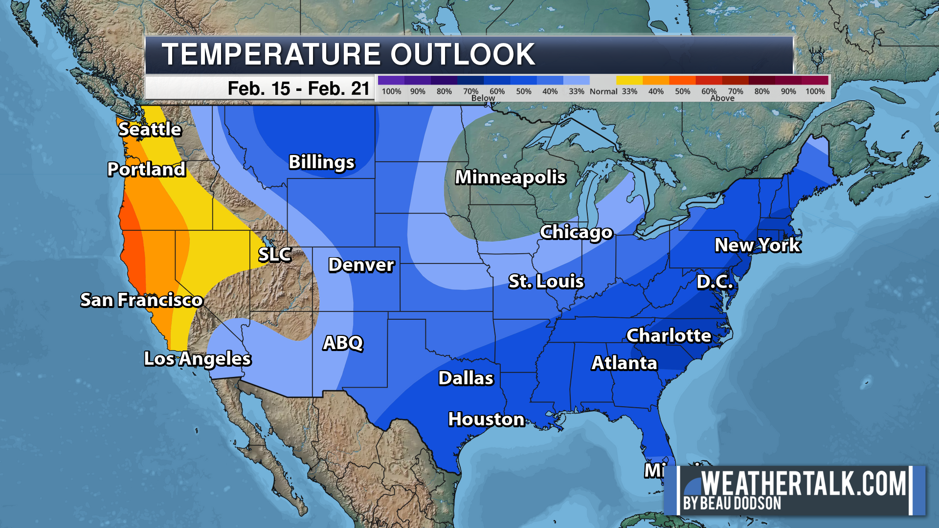
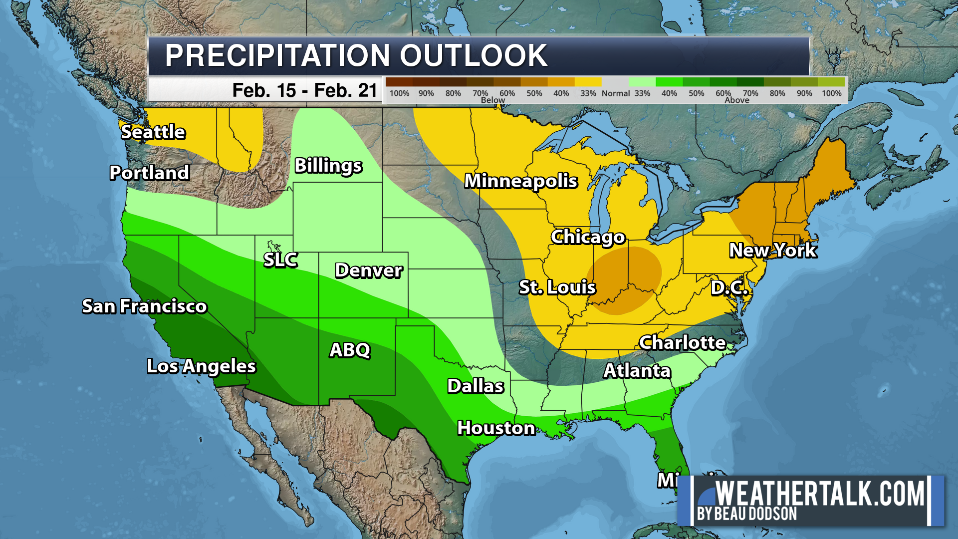
Eight to Fourteen Day Outlook.
Blue is below average. Red is above average. The no color zone represents equal chances.
Green is above average precipitation. Yellow and brown favors below average precipitation. Average precipitation for this time of the year is around one inch per week.
.
![]()
The app is for subscribers. Subscribe at www.weathertalk.com/welcome then go to your app store and search for WeatherTalk
Subscribers, PLEASE USE THE APP. ATT and Verizon are not reliable during severe weather. They are delaying text messages.
The app is under WeatherTalk in the app store.

Apple users click here

Android users click here
.

Radars and Lightning Data
Interactive-city-view radars. Clickable watches and warnings.
https://wtalk.co/B3XHASFZ
If the radar is not updating then try another one. If a radar does not appear to be refreshing then hit Ctrl F5. You may also try restarting your browser.
Backup radar site in case the above one is not working.
https://weathertalk.com/morani
Regional Radar
https://imagery.weathertalk.com/prx/RadarLoop.mp4
** NEW ** Zoom radar with chaser tracking abilities!
ZoomRadar
Lightning Data (zoom in and out of your local area)
https://wtalk.co/WJ3SN5UZ
Not working? Email me at beaudodson@usawx.com
National map of weather watches and warnings. Click here.
Storm Prediction Center. Click here.
Weather Prediction Center. Click here.
.

Live lightning data: Click here.
Real time lightning data (another one) https://map.blitzortung.org/#5.02/37.95/-86.99
Our new Zoom radar with storm chases
.
.

Interactive GOES R satellite. Track clouds. Click here.
GOES 16 slider tool. Click here.
College of DuPage satellites. Click here
.

Here are the latest local river stage forecast numbers Click Here.
Here are the latest lake stage forecast numbers for Kentucky Lake and Lake Barkley Click Here.
.
.
Find Beau on Facebook! Click the banner.


 .
.