
Click one of the links below to take you directly to that section
![]()
![]()
![]()
![]()
![]()
![]()
![]()
Do you have any suggestions or comments? Email me at beaudodson@usawx.com
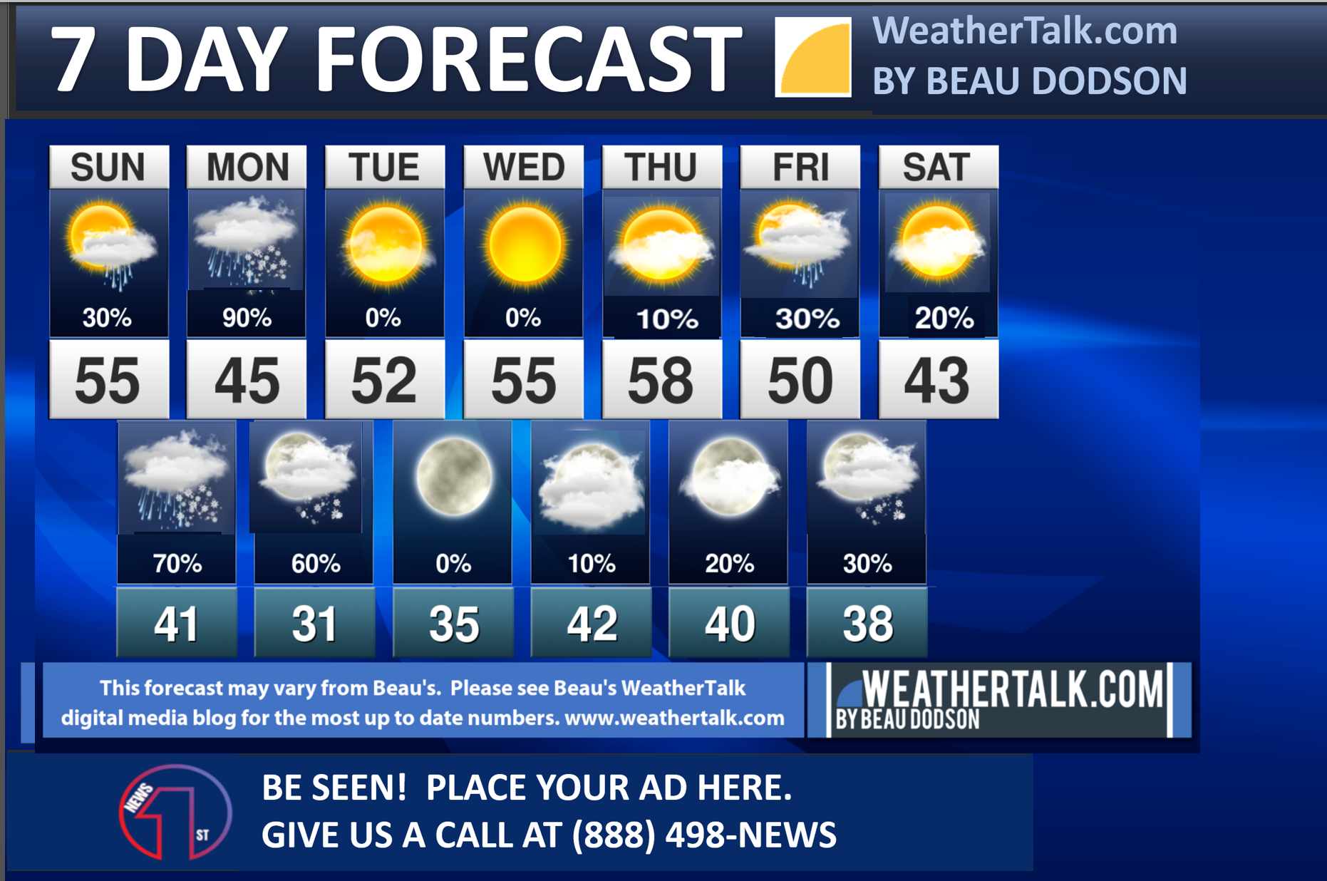
Seven-day forecast for southeast Missouri, southern Illinois, western Kentucky, and western Tennessee.
This is a BLEND for the region. Scroll down to see the region by region forecast.
THE FORECAST IS GOING TO VARY FROM LOCATION TO LOCATION. Scroll down to see the region by region forecast.
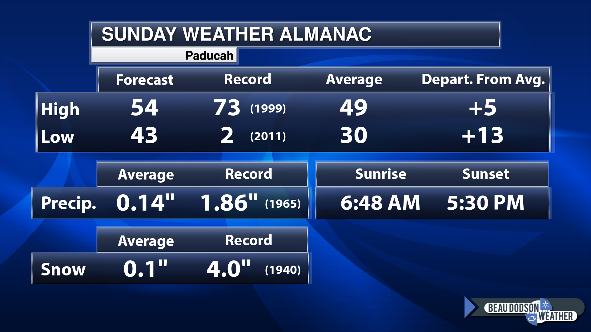
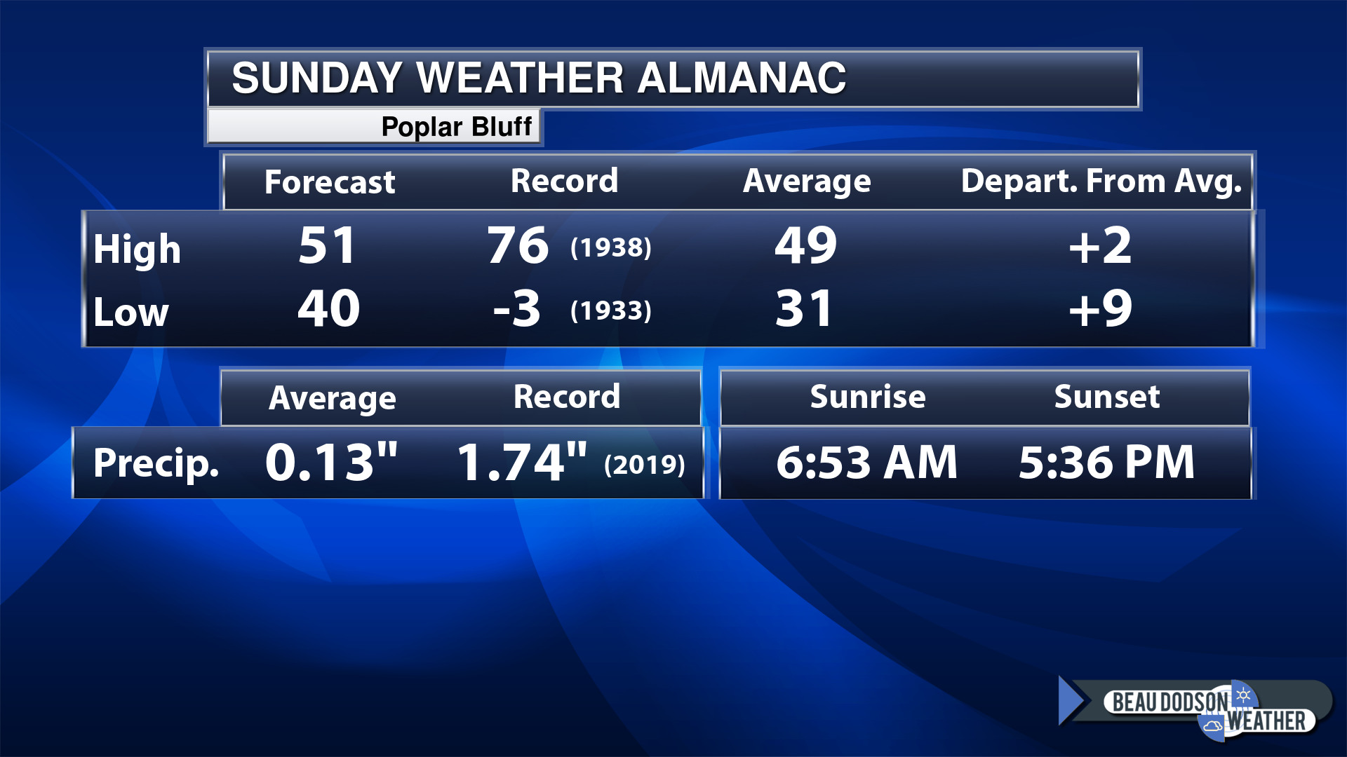
Today’s Local Almanacs (for a few select cities). Your location will be comparable.
Note, the low is this morning’s low and not tomorrows.
Today’s almanac numbers from a few select local cities.
The forecast temperature shows you today’s expected high and this morning’s low.
The graphic shows you the record high and record low for today. It shows you what year that occurred, as well.
It then shows you what today’s average temperature is.
Then, it shows you the departures (how may degrees above or below average temperatures will be ).
It shows you the average precipitation for today. Average comes from thirty years of rain totals.
It also shows you the record rainfall for the date and what year that occurred.
The sunrise and sunset are also shown.

If you have not subscribed to my YouTube Channel then click on this link and it will take you to my videos.
Click the button below and it will take you to the Beau Dodson YouTube Channel.

![]()
48-hour forecast


.

.
Sunday to Sunday
1. Is lightning in the forecast? YES. Lightning is possible tonight and Monday.
2. Are severe thunderstorms in the forecast? NO.
3. Is flash flooding in the forecast? NO.
4. Will the heat index exceed 100 degrees? NO.
5. Will the wind chill dip below 10 degrees? NO.
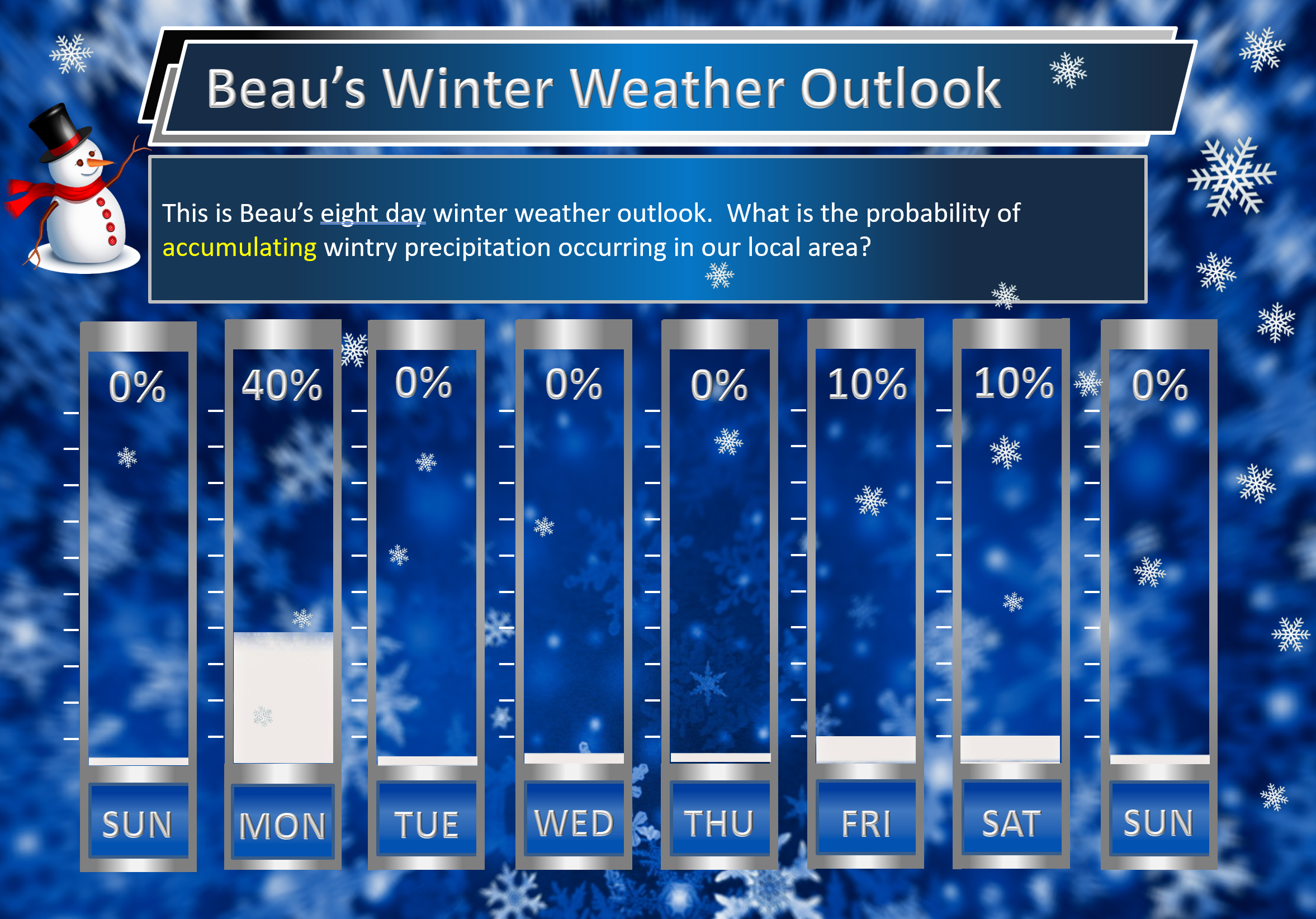
6. Is measurable snow and/or sleet in the forecast? YES (for some). Wet snow (and some sleet) accumulation is possible Monday/Monday evening across portions of southeast MO and southern IL. I will need to monitor the rest of the area. The ground is warm. Roads are warm. The snow will have to come down at a steady pace or heavy pace to accumulate. Accumulation on grassy surfaces is more likely than other areas. Monitor updates. Sometimes these systems can produce surprises. See discussion below.
I am watching next Friday night into Saturday night. A cold front will push through the region. Rain and snow will be possible along the front.
7. Is freezing rain/ice in the forecast? MONITOR. I will keep an eye on a cold front Friday night and Saturday.
Freezing rain is rain that falls and instantly freezes on objects such as trees and power lines Freezing fog possible, as well.
.
Fire weather risk level.
Sunday: 4. Low risk.
Sunday night. 3. Very low risk.
Monday through Monday night: 3. Very low risk.
Fire Weather Discussion
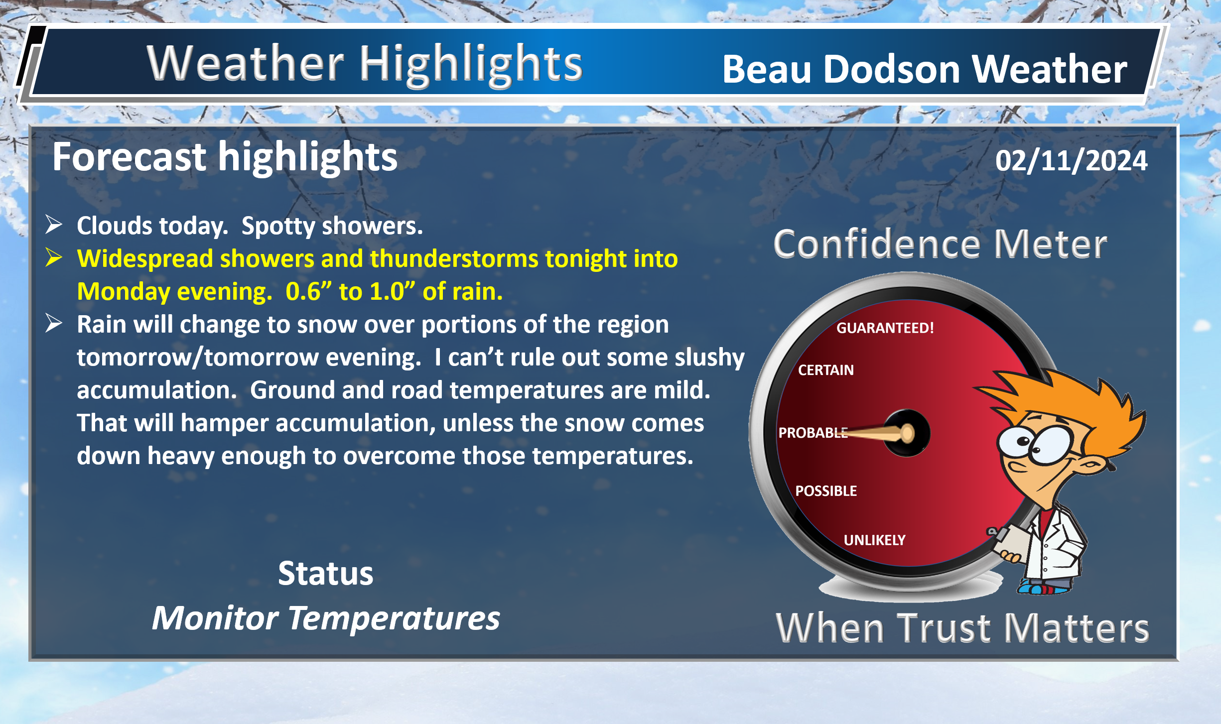
Rain chances return again tonight. The off and on chances will linger into Monday, then as the main storm system makes its passage, it draws in some colder air that could end precipitation with a brief mix or change over from rain to snow. A transition to more seasonally cool temperatures will occur during this time frame, before a return to some milder temperatures later in the week.
A Haines Index of 6 means a high potential for an existing fire to become large or exhibit erratic fire behavior, 5 means medium potential, 4 means low potential, and anything less than 4 means very low potential.
.

.
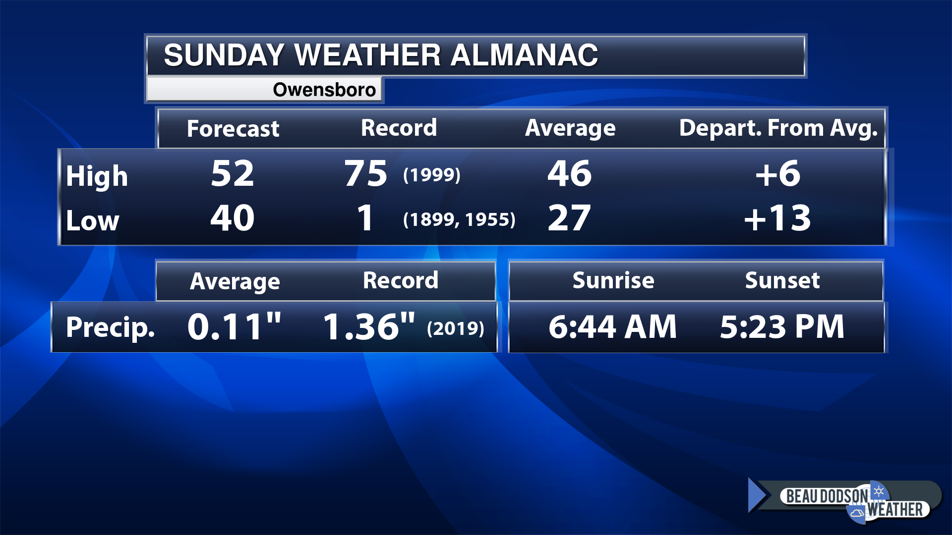
Sunday, February 11, 2024
Confidence in the forecast? High Confidence
Sunday Forecast: A mix of sun and clouds. A slight chance of showers.
What is the chance of precipitation?
Far northern southeast Missouri ~ 10%
Southeast Missouri ~ 10%
The Missouri Bootheel ~ 20%
I-64 Corridor of southern Illinois ~ 10%
Southern Illinois ~ 10%
Extreme southern Illinois (southern seven counties) ~ 10%
Far western Kentucky (Purchase area) ~ 20%
The Pennyrile area of western KY ~ 20%
Northwest Kentucky (near Indiana border) ~ 10%
Northwest Tennessee ~ 20%
Coverage of precipitation: Isolated
Timing of the precipitation: Any given point of time.
Far northern southeast Missouri ~ 46° to 50°
Southeast Missouri ~ 46° to 50°
The Missouri Bootheel ~ 50° to 52°
I-64 Corridor of southern Illinois ~ 46° to 50°
Southern Illinois ~ 50° to 52°
Extreme southern Illinois (southern seven counties) ~ 50° to 54°
Far western Kentucky ~ 52° to 55°
The Pennyrile area of western KY ~ 54° to 58°
Northwest Kentucky (near Indiana border 50° to 52°
Winds will be from this direction: North northeast 10 to 20 mph
Wind chill or heat index (feels like) temperature forecast: 46° to 54°
What impacts are anticipated from the weather? Wet roadways.
Should I cancel my outdoor plans? No, but monitor the Beau Dodson Weather Radars
UV Index: 3. Moderate.
Sunrise: 6:48 AM
Sunset: 5:30 PM .
.
Sunday Night Forecast: Thickening clouds. Widespread rain developing. Rain may mix with snow and sleet over our northwest counties.
What is the chance of precipitation?
Far northern southeast Missouri ~ 40%
Southeast Missouri ~ 60%
The Missouri Bootheel ~ 70%
I-64 Corridor of southern Illinois ~ 40%
Southern Illinois ~ 40%
Extreme southern Illinois (southern seven counties) ~ 40%
Far western Kentucky (Purchase area) ~ 40%
The Pennyrile area of western KY ~ 40%
Northwest Kentucky (near Indiana border) ~ 30%
Northwest Tennessee ~ 60%
Coverage of precipitation: Scattered before midnight. More numerous late at night.
Timing of the precipitation: Any given point of time.
Temperature range:
Far northern southeast Missouri 33° to 36°
Southeast Missouri ~ 34° to 36°
The Missouri Bootheel ~ 38° to 42°
I-64 Corridor of southern Illinois ~ 33° to 36°
Southern Illinois ~ 34° to 36°
Extreme southern Illinois (southern seven counties) ~ 38° to 42°
Far western Kentucky ~ 40° to 42°
The Pennyrile area of western KY ~ 43° to 46°
Northwest Kentucky (near Indiana border) ~ 40° to 44°
Northwest Tennessee ~ 43° to 46°
Winds will be from this direction: Northeast 10 to 25 mph
Wind chill or heat index (feels like) temperature forecast: 28° to 38°
What impacts are anticipated from the weather? Wet roadways. Monitor updates on snow.
Should I cancel my outdoor plans? Have a plan B and monitor the Beau Dodson Weather Radars
Moonrise: 8:08 AM
Moonset: 7:49 PM
The phase of the moon: Waxing Crescent
.
Monday, February 12, 2024
Confidence in the forecast? High Confidence
A wide range of high temperatures Monday. Here are some graphics.
Temperatures will be dependent on where the snow rain line is drawn.
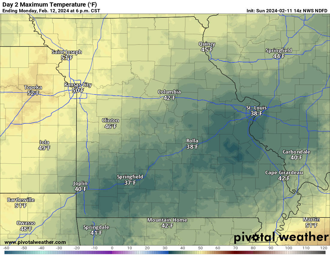
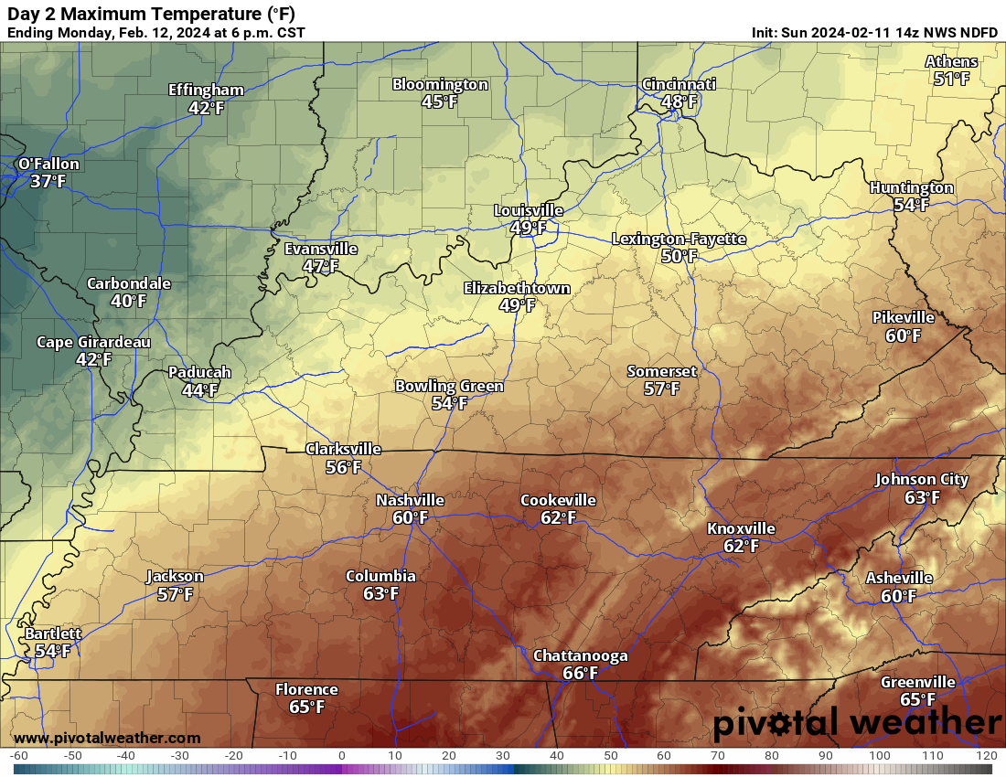
There remain questions on where to place the rain snow line.
This is where the NWS has placed it, for now. There could still be adjustments. This is Monday morning and afternoon.
This morning’s data showed it a bit farther south and east. This can’t be ruled out. Monitor updated forecasts.
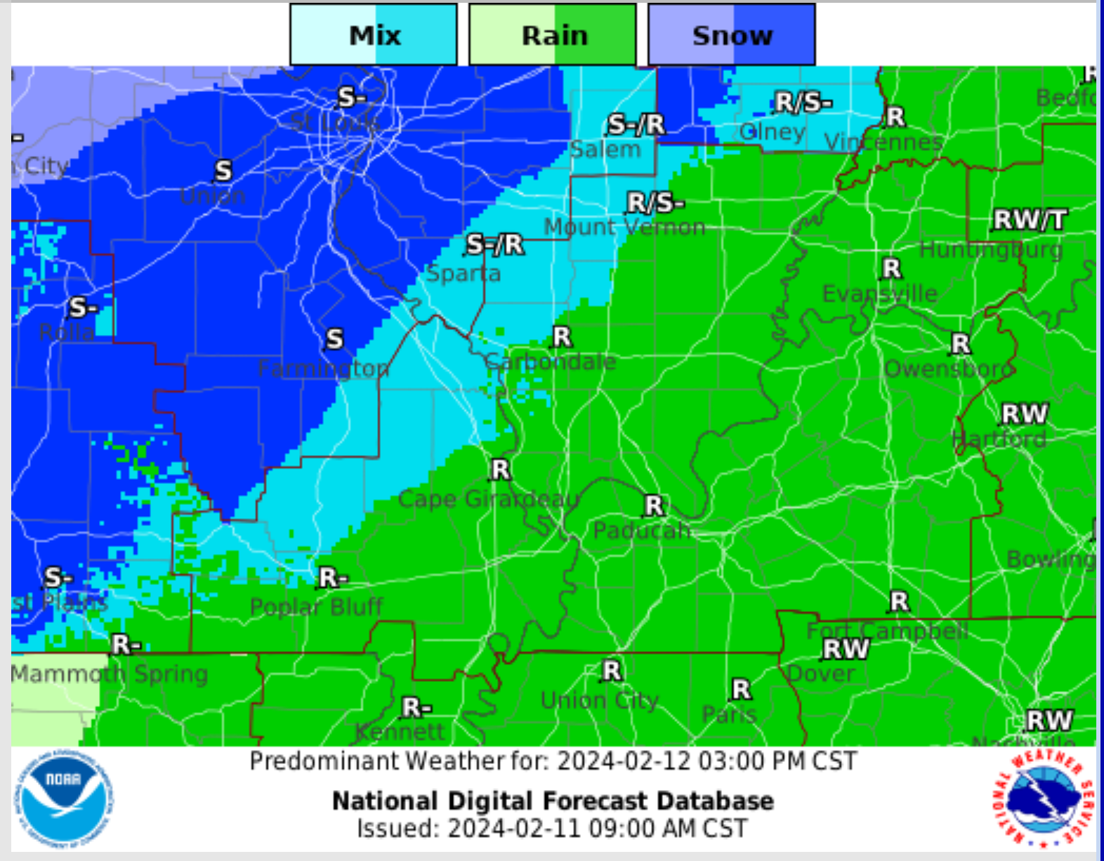
Monday Forecast: Cloudy. Showers and thunderstorms likely. Rain and snow/sleet across portions of southeast Missouri and southern Illinois. Gust winds.
What is the chance of precipitation?
Far northern southeast Missouri ~ 90%
Southeast Missouri ~ 90%
The Missouri Bootheel ~ 100%
I-64 Corridor of southern Illinois ~ 90%
Southern Illinois ~ 90%
Extreme southern Illinois (southern seven counties) ~ 100%
Far western Kentucky (Purchase area) ~ 100%
The Pennyrile area of western KY ~ 90%
Northwest Kentucky (near Indiana border) ~ 90%
Northwest Tennessee ~ 100%
Coverage of precipitation: Widespread
Timing of the precipitation: Any given point of time.
Far northern southeast Missouri ~ 36° to 38°
Southeast Missouri ~ 38° to 40°
The Missouri Bootheel ~ 43° to 46
I-64 Corridor of southern Illinois ~ 36° to 38°
Southern Illinois ~ 38° to 42°
Extreme southern Illinois (southern seven counties) ~ 40° to 44°
Far western Kentucky ~ 42° to 45°
The Pennyrile area of western KY ~ 48° to 52°
Northwest Kentucky (near Indiana border 42° to 44°
Northwest Tennessee ~ 44° to 48°
Winds will be from this direction: Northeast 10 to 25 mph. Gusty.
Wind chill or heat index (feels like) temperature forecast: 28° to 44°
What impacts are anticipated from the weather? Wet roadways. Monitor updates on snow.
Should I cancel my outdoor plans? Have a plan B and monitor the Beau Dodson Weather Radars.
UV Index: 2. Low.
Sunrise: 6:47 AM
Sunset: 5:31 PM .
.
Monday Night Forecast: Mostly cloudy. Showers and thunderstorms pushing off to the east. Rain will change to snow/sleet elsewhere. Some light accumulation can’t be ruled out. Windy. Chilly.
Here is where the NWS places the rain snow line Monday night. Again, this may be farther southeast than shown. We will need to monitor it.
Time stamp bottom of image.

What is the chance of precipitation?
Far northern southeast Missouri ~ 60%
Southeast Missouri ~ 60%
The Missouri Bootheel ~ 60%
I-64 Corridor of southern Illinois ~ 70%
Southern Illinois ~ 70%
Extreme southern Illinois (southern seven counties) ~ 80%
Far western Kentucky (Purchase area) ~ 80%
The Pennyrile area of western KY ~ 80%
Northwest Kentucky (near Indiana border) ~ 70%
Northwest Tennessee ~ 70%
Coverage of precipitation: Numerous
Timing of the precipitation: Mainly before midnight.
Temperature range:
Far northern southeast Missouri 26° to 28°
Southeast Missouri ~ 26° to 28°
The Missouri Bootheel ~ 30° to 32°
I-64 Corridor of southern Illinois ~ 26° to 28°
Southern Illinois ~ 26° to 28°
Extreme southern Illinois (southern seven counties) ~ 28° to 30°
Far western Kentucky ~ 28° to 32°
The Pennyrile area of western KY ~ 30° to 32°
Northwest Kentucky (near Indiana border) ~ 30° to 32°
Northwest Tennessee ~ 32° to 34°
Winds will be from this direction: Northwest 10 to 25 mph. Gusty.
Wind chill or heat index (feels like) temperature forecast: 22° to 30°
What impacts are anticipated from the weather? Wet roadways. Monitor updates on snow.
Should I cancel my outdoor plans? Have a plan B and monitor the Beau Dodson Weather Radars
Moonrise: 8:34 AM
Moonset: 9:01 PM
The phase of the moon: Waxing Crescent
.
Tuesday Forecast: Becoming mostly sunny.
What is the chance of precipitation?
Far northern southeast Missouri ~ 0%
Southeast Missouri ~ 0%
The Missouri Bootheel ~ 0%
I-64 Corridor of southern Illinois ~ 0%
Southern Illinois ~ 0%
Extreme southern Illinois (southern seven counties) ~ 0%
Far western Kentucky (Purchase area) ~ 0%
The Pennyrile area of western KY ~ 0%
Northwest Kentucky (near Indiana border) ~ 0%
Northwest Tennessee ~ 0%
Coverage of precipitation:
Timing of the precipitation:
Far northern southeast Missouri ~ 48° to 52°
Southeast Missouri ~ 48° to 52°
The Missouri Bootheel ~ 48° to 52°
I-64 Corridor of southern Illinois ~ 48° to 52°
Southern Illinois ~ 48° to 52°
Extreme southern Illinois (southern seven counties) ~ 48° to 52°
Far western Kentucky ~ 48° to 52°
The Pennyrile area of western KY ~ 48° to 52°
Northwest Kentucky (near Indiana border ~ 48° to 52°
Northwest Tennessee ~ 48° to 52°
Winds will be from this direction: West 7 to 14 mph
Wind chill or heat index (feels like) temperature forecast: 45° to 50°
What impacts are anticipated from the weather?
Should I cancel my outdoor plans?
UV Index: 4. Moderate.
Sunrise: 6:46 AM
Sunset: 5:32 PM .
.
Tuesday Night Forecast: Mostly clear.
What is the chance of precipitation?
Far northern southeast Missouri ~ 0%
Southeast Missouri ~ 0%
The Missouri Bootheel ~ 0%
I-64 Corridor of southern Illinois ~ 0%
Southern Illinois ~ 0%
Extreme southern Illinois (southern seven counties) ~ 0%
Far western Kentucky (Purchase area) ~ 0%
The Pennyrile area of western KY ~ 0%
Northwest Kentucky (near Indiana border) ~ 0%
Northwest Tennessee ~ 0%
Coverage of precipitation:
Timing of the precipitation:
Temperature range:
Far northern southeast Missouri 30° to 34°
Southeast Missouri ~ 30° to 34°
The Missouri Bootheel ~ 30° to 34°
I-64 Corridor of southern Illinois ~ 30° to 34°
Southern Illinois ~ 30° to 34°
Extreme southern Illinois (southern seven counties) ~ 30° to 34°
Far western Kentucky ~ 30° to 34°
The Pennyrile area of western KY ~ 30° to 34°
Northwest Kentucky (near Indiana border) ~ 30° to 34°
Northwest Tennessee ~ 30° to 34°
Winds will be from this direction: South southwest 5 to 10 mph
Wind chill or heat index (feels like) temperature forecast: 28° to 34°
What impacts are anticipated from the weather?
Should I cancel my outdoor plans?
Moonrise: 9:02 AM
Moonset: 10:15 PM
The phase of the moon: Waxing Crescent
.
Wednesday Forecast: Mostly sunny. Mild. Nice.
What is the chance of precipitation?
Far northern southeast Missouri ~ 0%
Southeast Missouri ~ 0%
The Missouri Bootheel ~ 0%
I-64 Corridor of southern Illinois ~ 0%
Southern Illinois ~ 0%
Extreme southern Illinois (southern seven counties) ~ 0%
Far western Kentucky (Purchase area) ~ 0%
The Pennyrile area of western KY ~ 0%
Northwest Kentucky (near Indiana border) ~ 0%
Northwest Tennessee ~ 0%
Coverage of precipitation:
Timing of the precipitation:
Far northern southeast Missouri ~ 58° to 60°
Southeast Missouri ~ 58° to 60°
The Missouri Bootheel ~ 58° to 60°
I-64 Corridor of southern Illinois ~ 58° to 60°
Southern Illinois ~ 58° to 60°
Extreme southern Illinois (southern seven counties) ~ 58° to 60°
Far western Kentucky ~ 58° to 60°
The Pennyrile area of western KY ~ 58° to 60°
Northwest Kentucky (near Indiana border 58° to 60°
Northwest Tennessee ~ 58° to 60°
Winds will be from this direction: South 7 to 14 mph.
Wind chill or heat index (feels like) temperature forecast: 58° to 60°
What impacts are anticipated from the weather?
Should I cancel my outdoor plans?
UV Index: 4. Moderate.
Sunrise: 6:45 AM
Sunset: 5:33 PM .
.
Wednesday Night Forecast: Increasing clouds. A chance of a shower over our northern counties.
What is the chance of precipitation?
Far northern southeast Missouri ~ 20%
Southeast Missouri ~ 10%
The Missouri Bootheel ~ 0%
I-64 Corridor of southern Illinois ~ 20%
Southern Illinois ~ 20%
Extreme southern Illinois (southern seven counties) ~ 10%
Far western Kentucky (Purchase area) ~ 0%
The Pennyrile area of western KY ~ 0%
Northwest Kentucky (near Indiana border) ~ 20%
Northwest Tennessee ~ 0%
Coverage of precipitation: Isolated
Timing of the precipitation: After 9 pm
Temperature range:
Far northern southeast Missouri 38° to 42°
Southeast Missouri ~ 38° to 42°
The Missouri Bootheel ~ 38° to 42°
I-64 Corridor of southern Illinois ~ 38° to 42°
Southern Illinois ~ 38° to 42°
Extreme southern Illinois (southern seven counties) ~ 38° to 42°
Far western Kentucky ~ 38° to 42°
The Pennyrile area of western KY ~ 38° to 42°
Northwest Kentucky (near Indiana border) ~ 38° to 42°
Northwest Tennessee ~ 38° to 42°
Winds will be from this direction: South 6 to 12 mph
Wind chill or heat index (feels like) temperature forecast: 36° to 42°
What impacts are anticipated from the weather? Wet roadways.
Should I cancel my outdoor plans?
Moonrise: 9:30 AM
Moonset: 11:27 PM
The phase of the moon: Waxing Crescent
.
Click here if you would like to return to the top of the page.

-
- Here comes more rain!
- Rain and snow. Portions of the region will experience snow and sleet. Wet slushy accumulation possible.
- Ground and road temperatures are warm. That may help cut down on impacts.
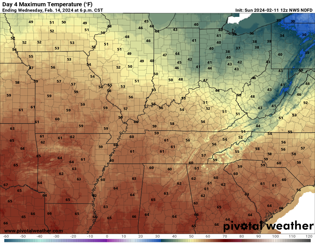
- Mild temperatures mid-week. Some locations will again hit 60 degrees! If some locations have a snowpack, then that would influence temperatures Tuesday and Wednesday.
- Strong cold front Friday/Saturday with rain rain/snow.
Weather advice:
Make sure you have three to five ways of receiving your severe weather information.
Forecast Discussion
Goo day, everyone. Sorry, I was off work the last couple of days. Under the weather.
I am feeling better now.
We have a complicated forecast over the next 24/36 hours.
An area of low pressure will move to our south southeast. That places portions of our region in the cold sector.
How cold is the question.
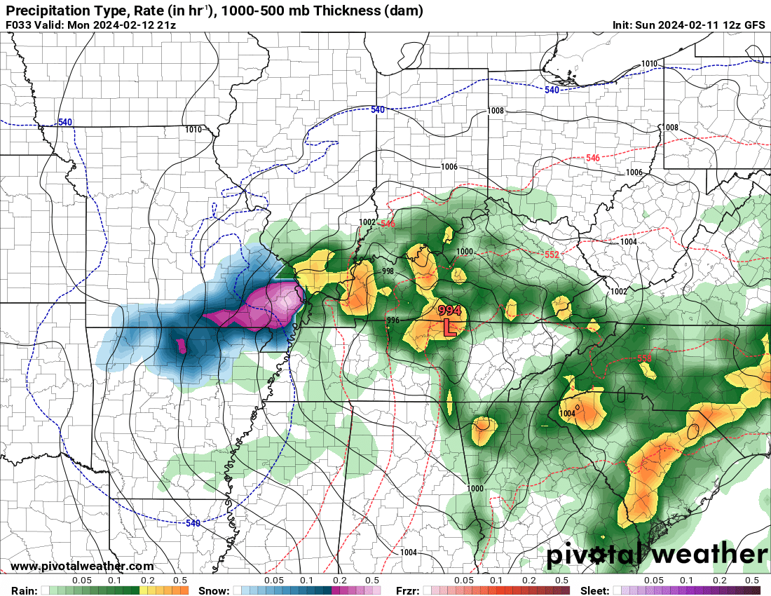
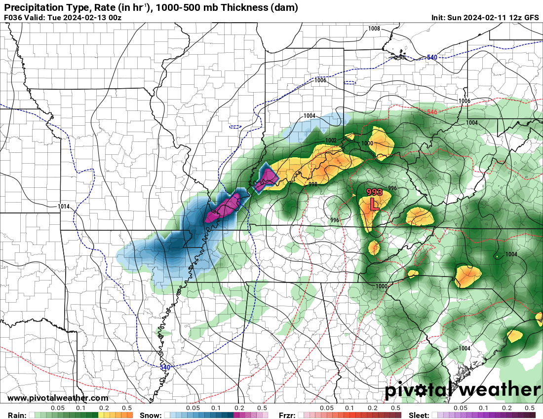
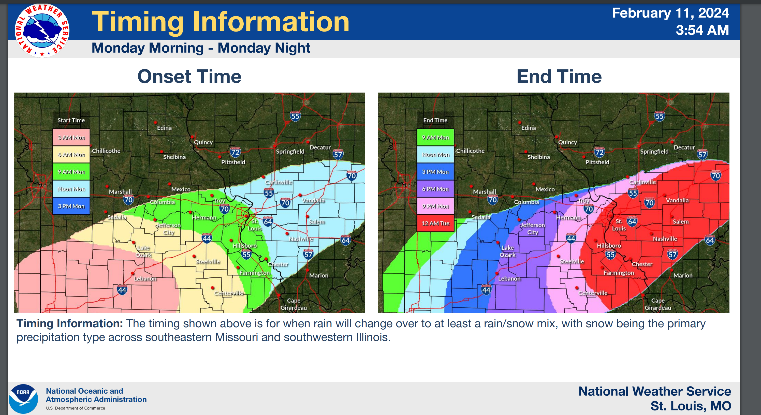
We will be drawing a rain snow line across portions of the region.
The GFS is fairly far south in its depiction of the rain/snow line. This is farther south than previous runs.
Blue and pink represents snow and sleet. Green and yellow would be the rain.
This is late Monday morning into Monday afternoon.
.
The NAM model is a bit farther north. By a county or two.
Showers and thunderstorms will push into the region tonight. Then, rain will change to snow on the back side of the system tomorrow morning into tomorrow evening. Again, we will need to closely where that snow rain line is placed.
A few things to keep in mind.
- Ground temperatures are quite warm. Road temperatures are warm.
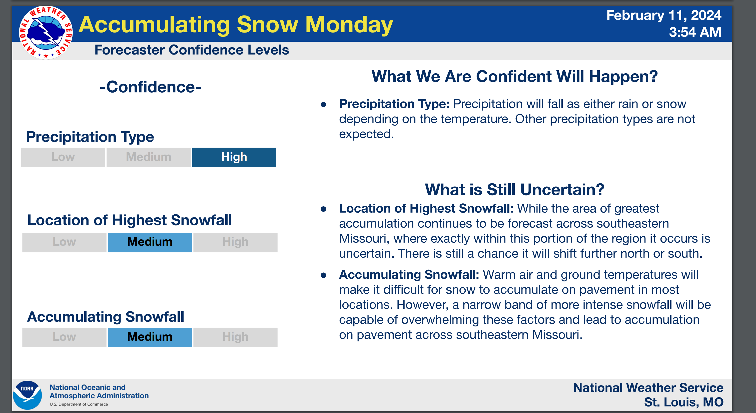
- There remain questions about where to draw the rain snow line. There will be a sharp gradient where no snow occurs and where some snow accumulation occurs.
- Some adjustments are still possible.
- Temperatures Tuesday and Wednesday will rise into the 40s and 50s. Perhaps even 60 by Wednesday. Whatever does fall will quickly melt.
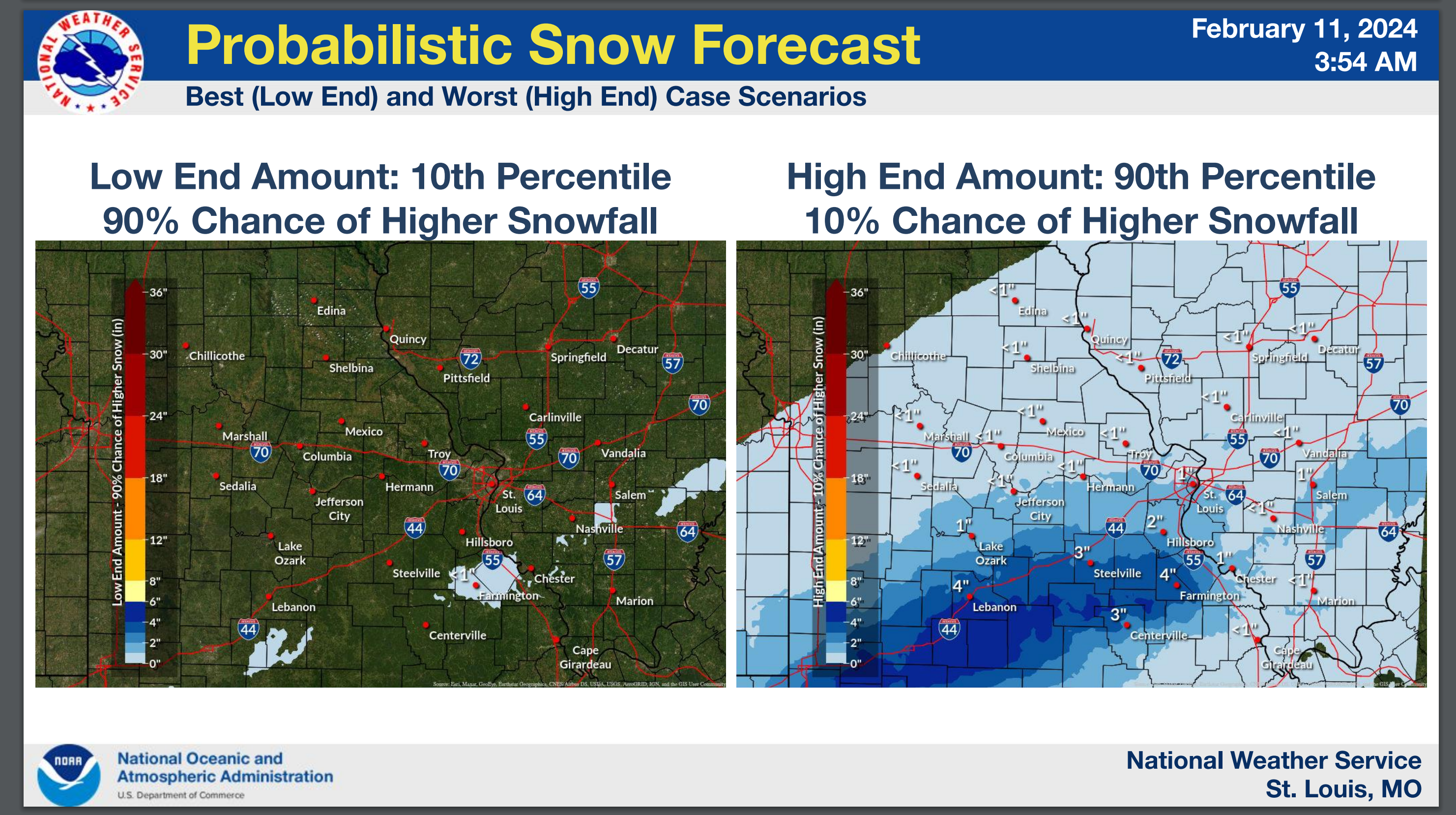
Let me show you a few graphics.
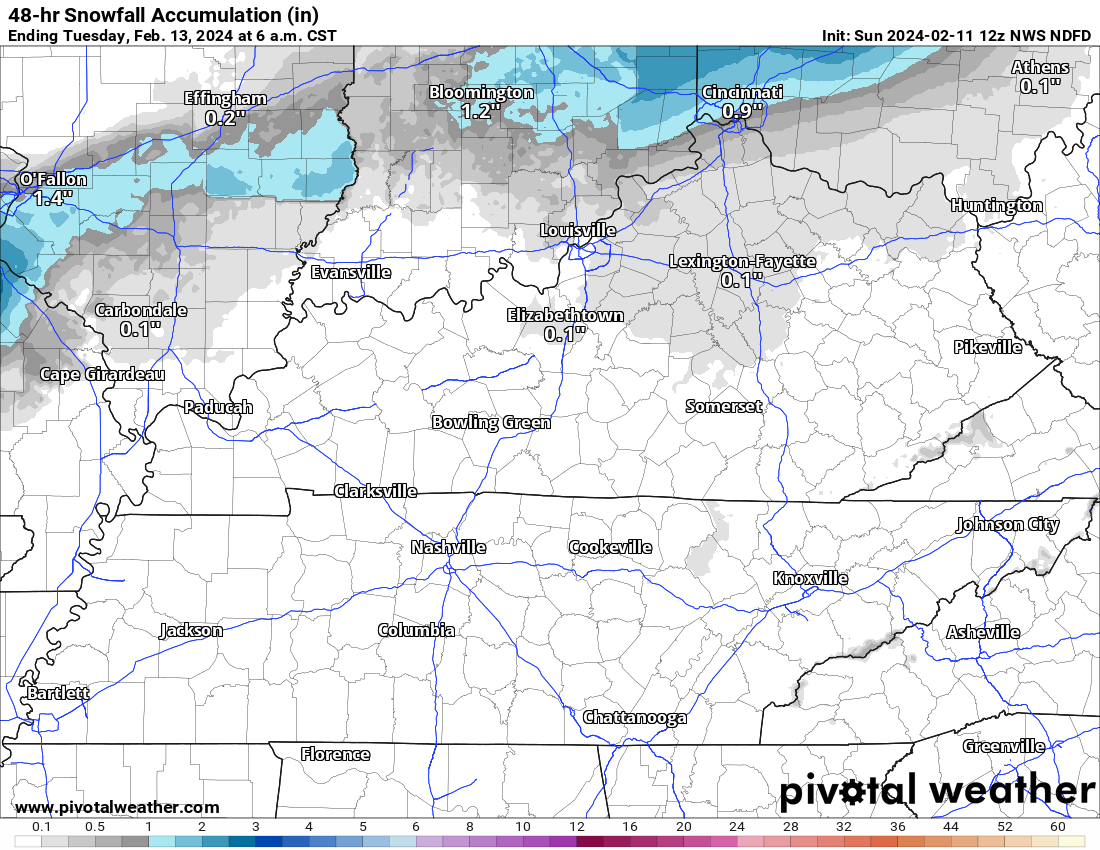
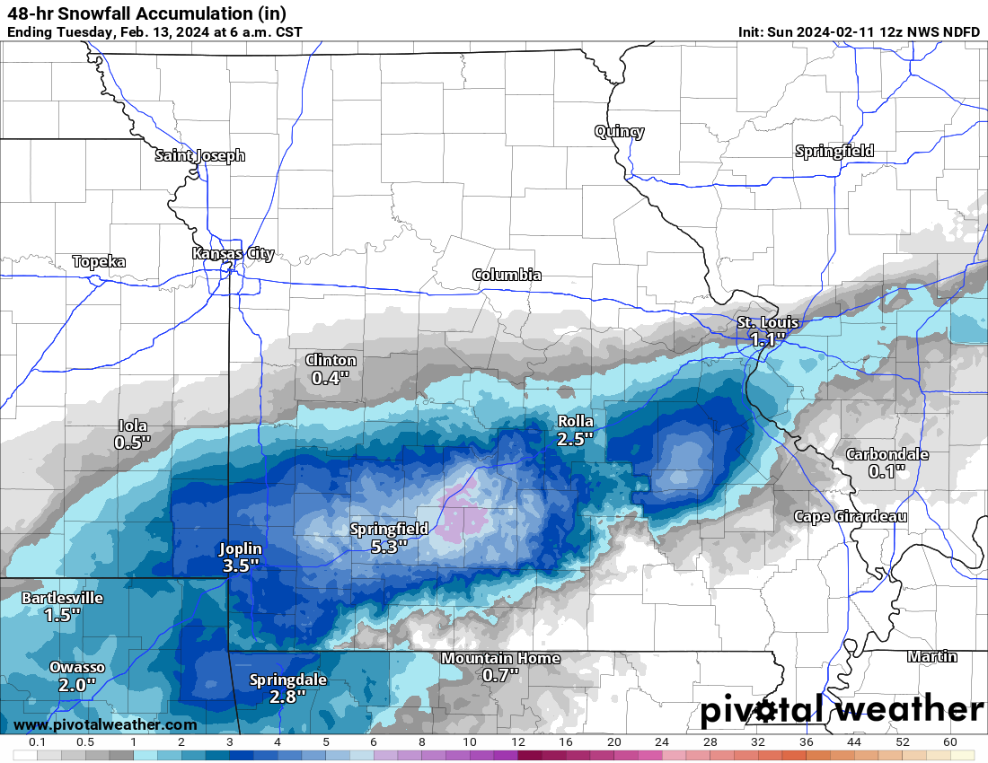
Here is the NWS NDFD snowfall forecast. Basically, this is what the NWS is forecasting.
Keep in mind, these type of systems can occasionally produce heavier totals. If the temperature is slight colder, then two to four inches would be possible.
For now, the NWS has lower end totals. They are fairly far north, as well.
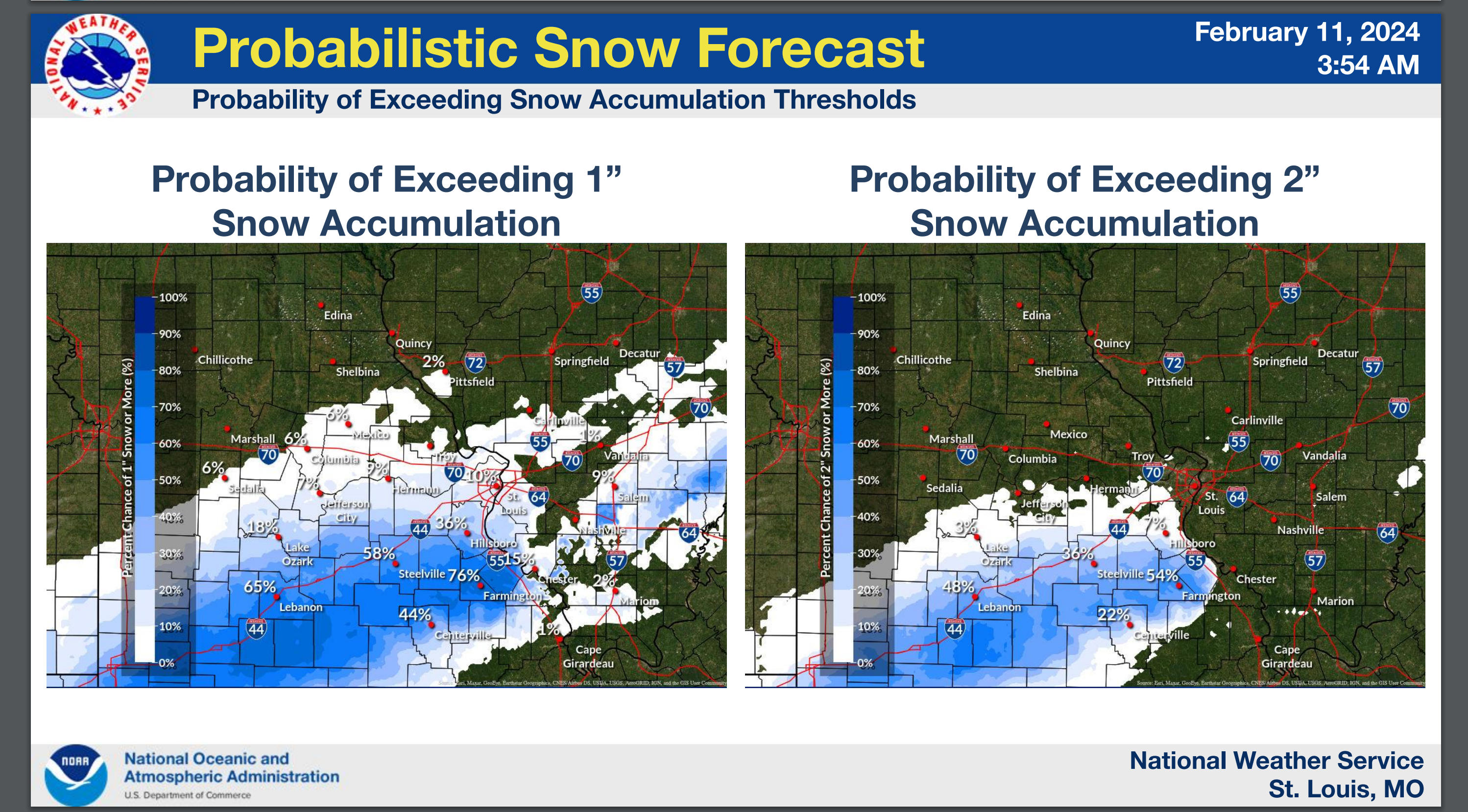
Here is a map from the WPC. What is the chance of one inch of snow.
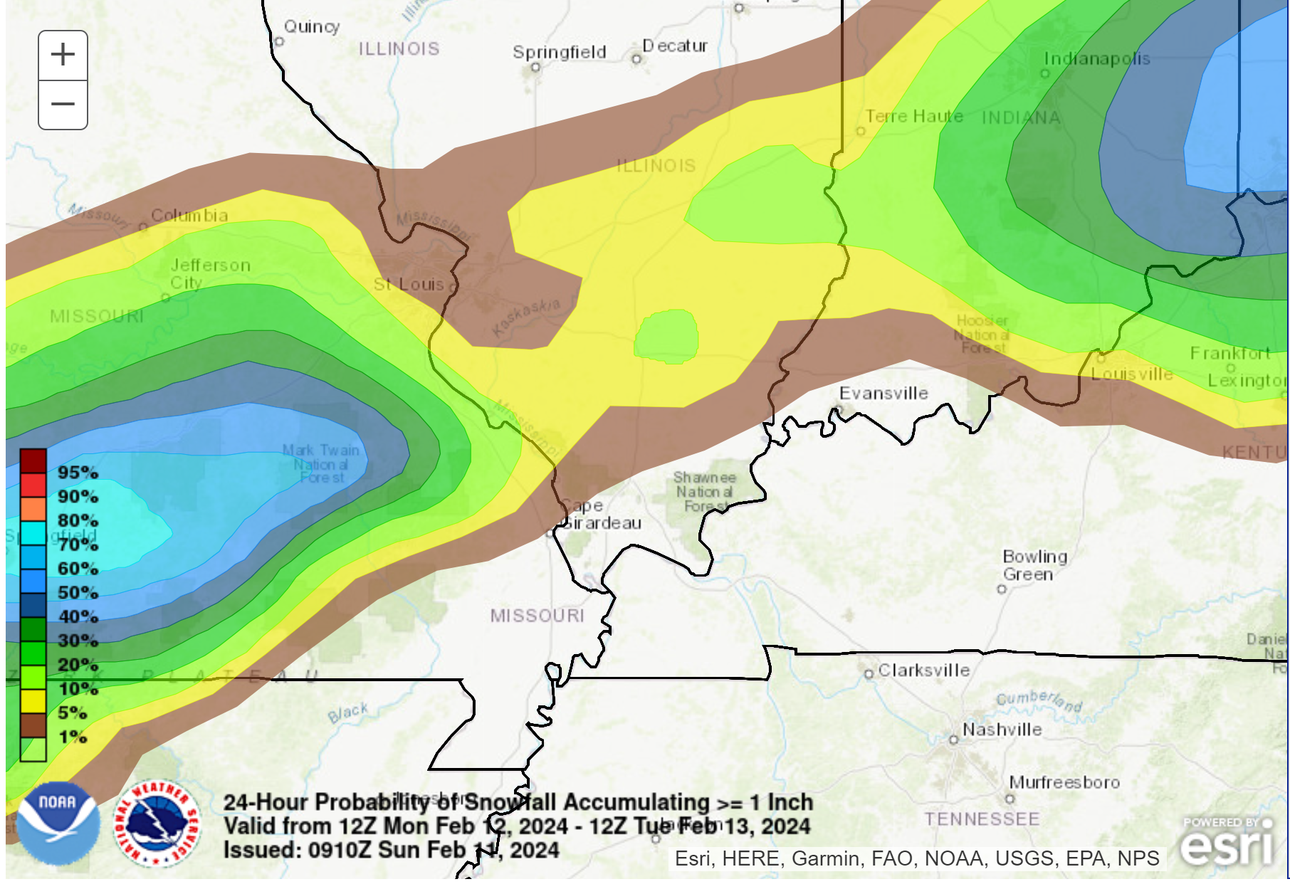
A couple of graphics from this morning’s data. Notice this is slightly farther south southeast. Click images to enlarge them.
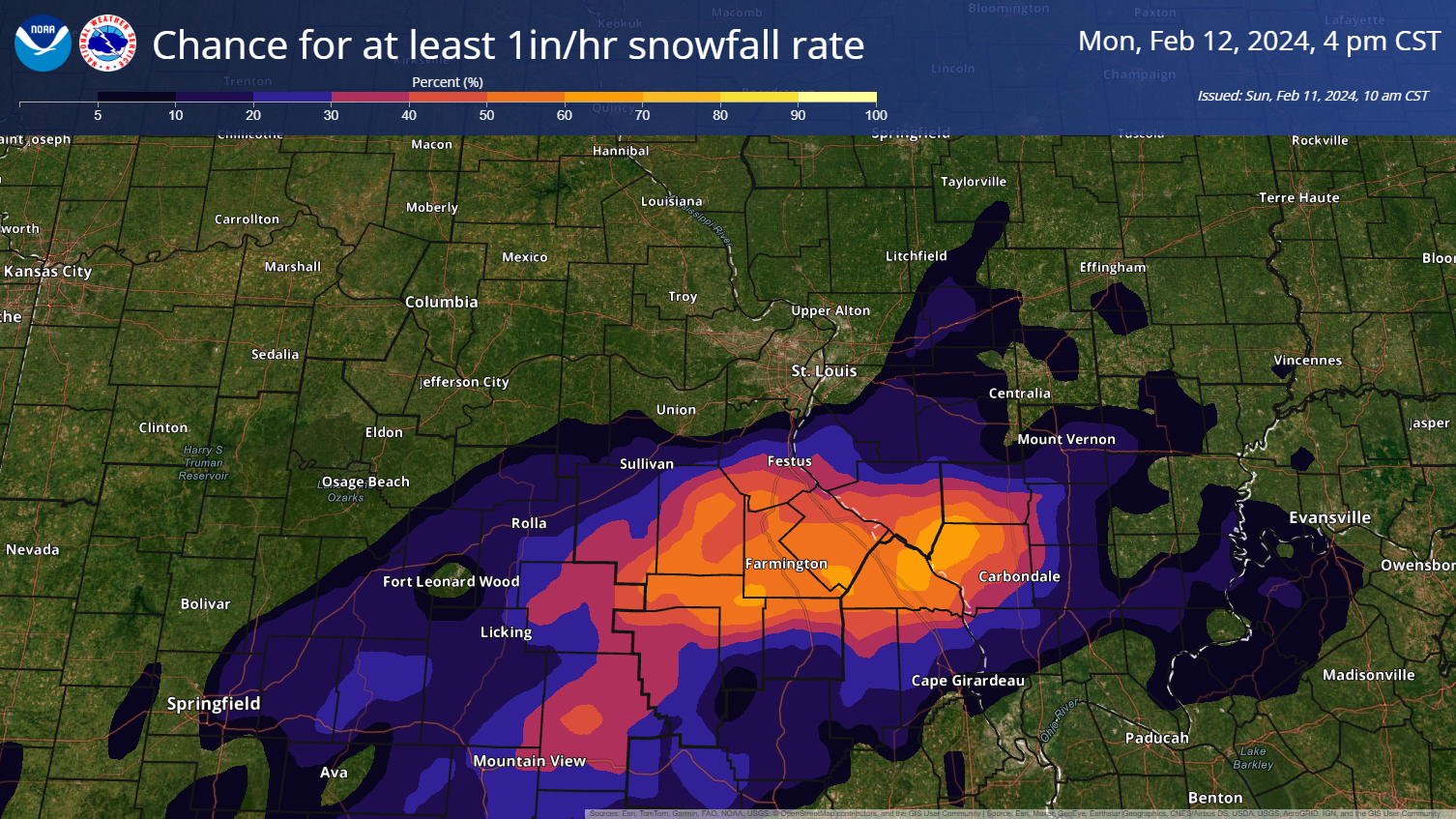
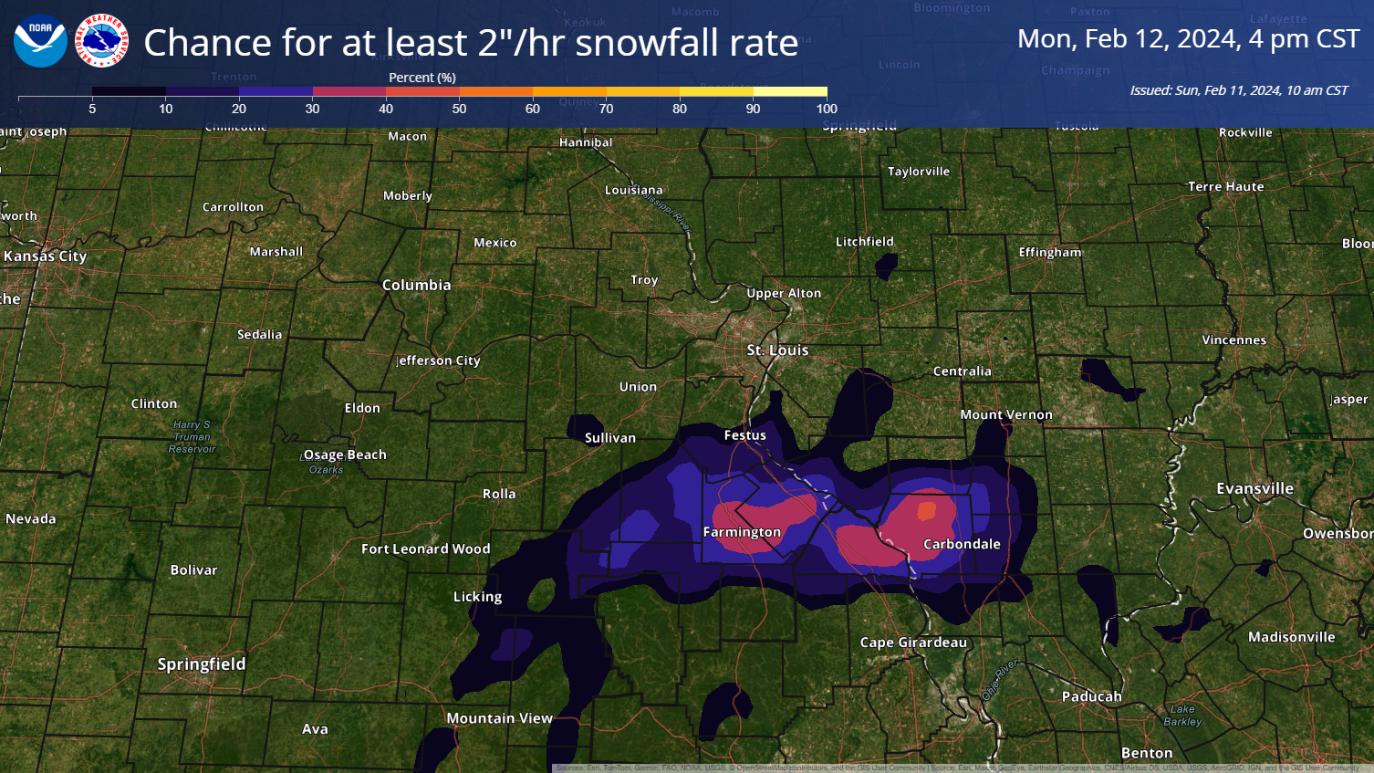
Here is a briefing from the St Louis, Missouri NWS.
Double click images to enlarge them.
These graphics are from the St Louis, NWS.
Here is a graphic from the Paducah, Kentucky, National Weather Service.
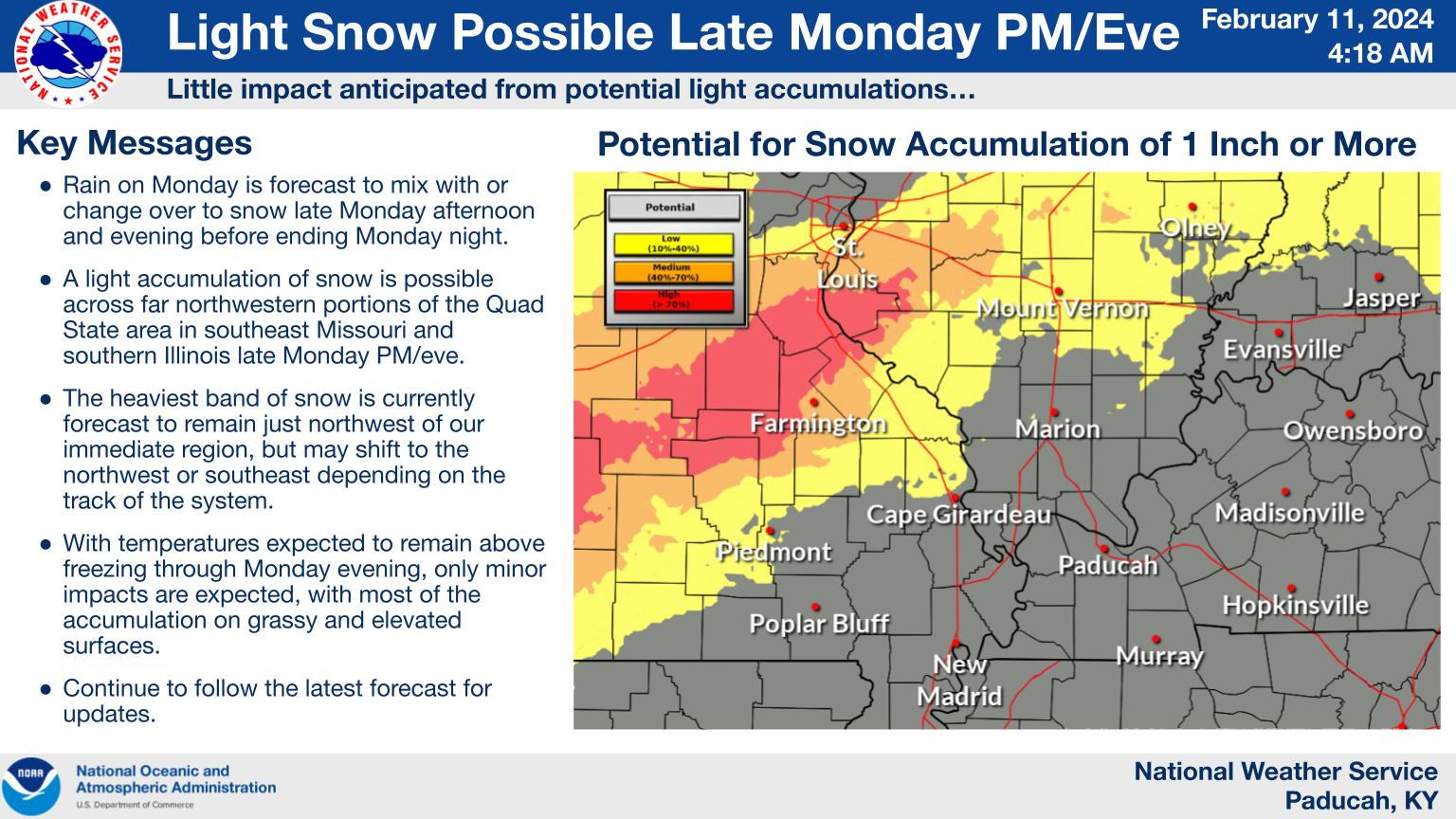
We will have to closely monitor this system. I have seen quite a few events like this. Many times there are surprises. Snow totals can sometimes be higher than expected.
The event is still 24 hours away. Some adjustments are possible.
The good news is that Tuesday and Wednesday will be quite mild. If there is a snow pack, then those areas will be cooler.
Whatever does fall would quickly melt Tuesday and Wednesday.
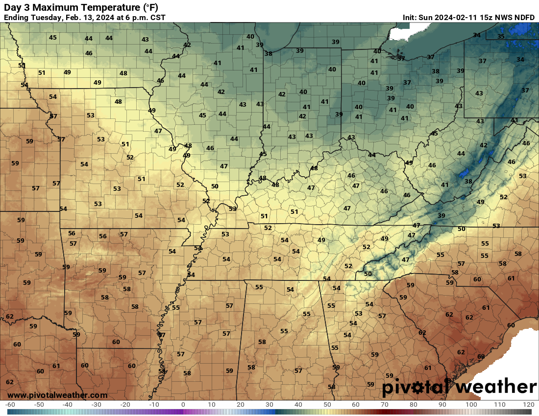
Tuesday highs
Wednesday highs
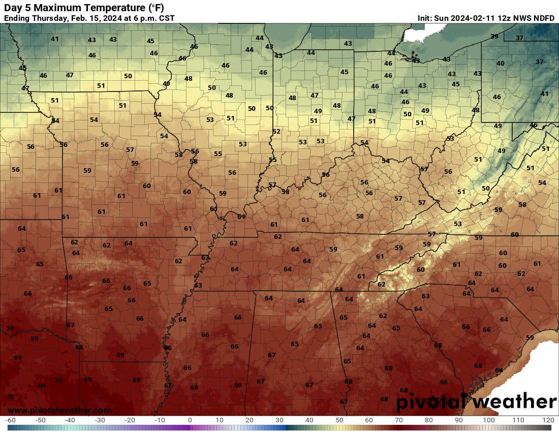
Thursday highs
A strong cold front will push through the region Friday into Saturday.
Showers and perhaps rain/snow showers will accompany it with falling temperatures.
![]()
.
Click here if you would like to return to the top of the page.
This outlook covers southeast Missouri, southern Illinois, western Kentucky, and far northwest Tennessee.

.
Today’s Storm Prediction Center’s Severe Weather Outlook
Light green is where thunderstorms may occur but should be below severe levels.
Dark green is a level one risk. Yellow is a level two risk. Orange is a level three (enhanced) risk. Red is a level four (moderate) risk. Pink is a level five (high) risk.
One is the lowest risk. Five is the highest risk.
A severe storm is one that produces 58 mph wind or higher, quarter size hail, and/or a tornado.
Explanation of tables. Click here.

.
Tornado Probability Outlook

.
Large Hail Probability Outlook

.
High wind Probability Outlook

.
Tomorrow’s severe weather outlook.

.
Day Three Severe Weather Outlook

.

.
The images below are from NOAA’s Weather Prediction Center.
24-hour precipitation outlook..
 .
.
.
48-hour precipitation outlook.
. .
.
![]()
_______________________________________
.

Click here if you would like to return to the top of the page.
Again, as a reminder, these are models. They are never 100% accurate. Take the general idea from them.
What should I take from these?
- The general idea and not specifics. Models usually do well with the generalities.
- The time-stamp is located in the upper left corner.
.
What am I looking at?
You are looking at computer model data. Meteorologists use many different models to forecast the weather.
Occasionally, these maps are in Zulu time. 12z=7 AM. 18z=1 PM. 00z=7 PM. 06z=1 AM
Green represents light rain. Dark green represents moderate rain. Yellow and orange represent heavier rain.
.
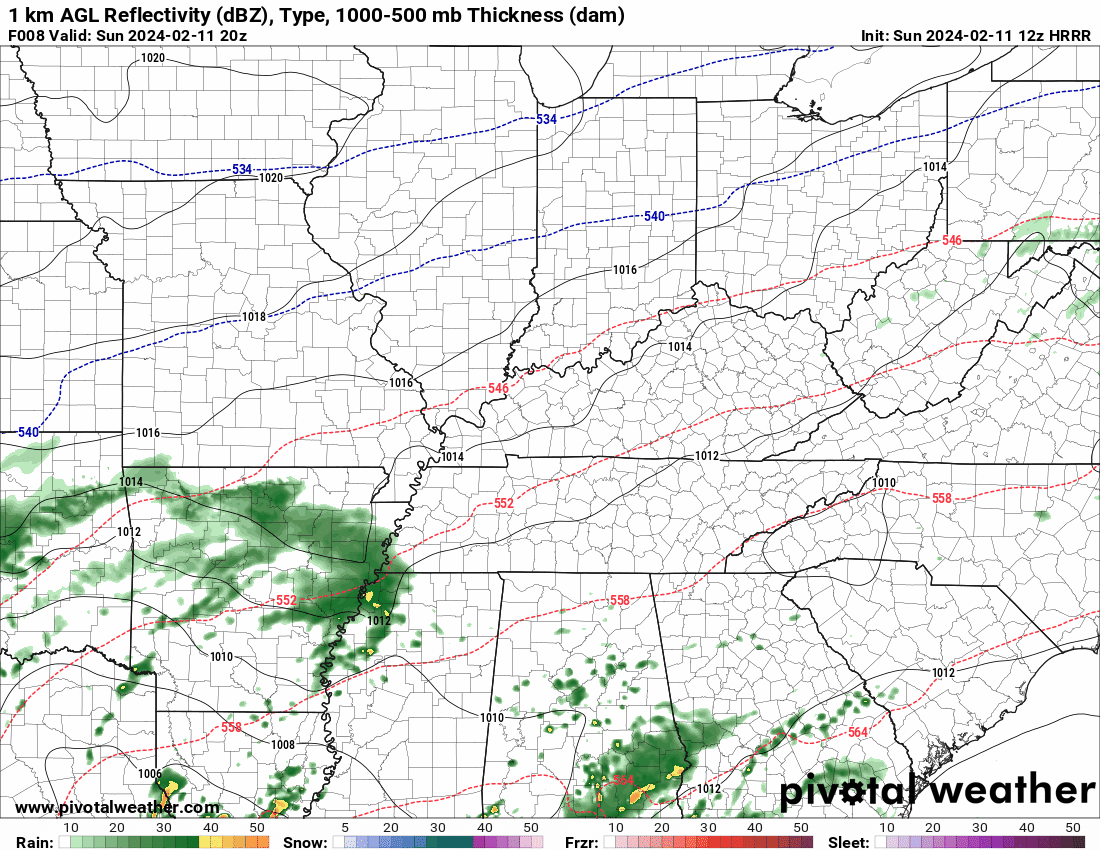
This animation is the HRRR Model.
Occasionally, these maps are in Zulu time. 12z=6 AM. 18z=12 PM. 00z=6 PM. 06z=12 AM
Double click images to enlarge them. Blue is snow. Pink is a wintry mix. Green is rain.
.
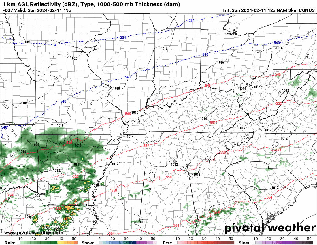
This animation is the NAM 3K Model.
Occasionally, these maps are in Zulu time. 12z=6 AM. 18z=12 PM. 00z=6 PM. 06z=12 AM
Double click images to enlarge them.
.
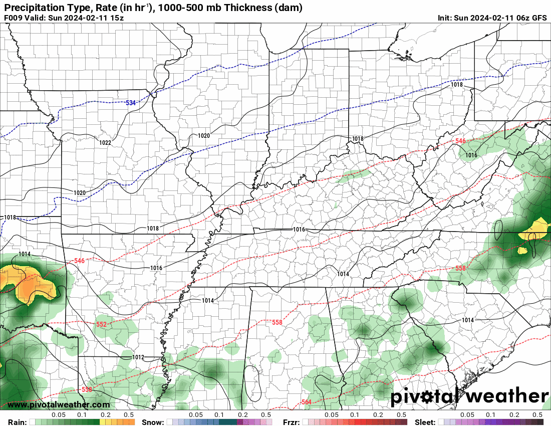
This animation is the GFS Model.
Green is rain. Yellow and orange are heavier rain. Pink is a wintry mix. Blue is snow. Dark blue is heavier snow.
Occasionally, these maps are in Zulu time. 12z=6 AM. 18z=12 PM. 00z=6 PM. 06z=12 AM
Double click images to enlarge them.
.
This animation is the EC Model.
Green is rain. Yellow and orange are heavier rain. Pink is a wintry mix. Blue is snow. Dark blue is heavier snow.
Occasionally, these maps are in Zulu time. 12z=6 AM. 18z=12 PM. 00z=6 PM. 06z=12 AM
Double click images to enlarge them.
..![]()

.
Click here if you would like to return to the top of the page.
.Average high temperatures for this time of the year are around 46 degrees.
Average low temperatures for this time of the year are around 28 degrees.
Average precipitation during this time period ranges from 0.50″ to 1.00″
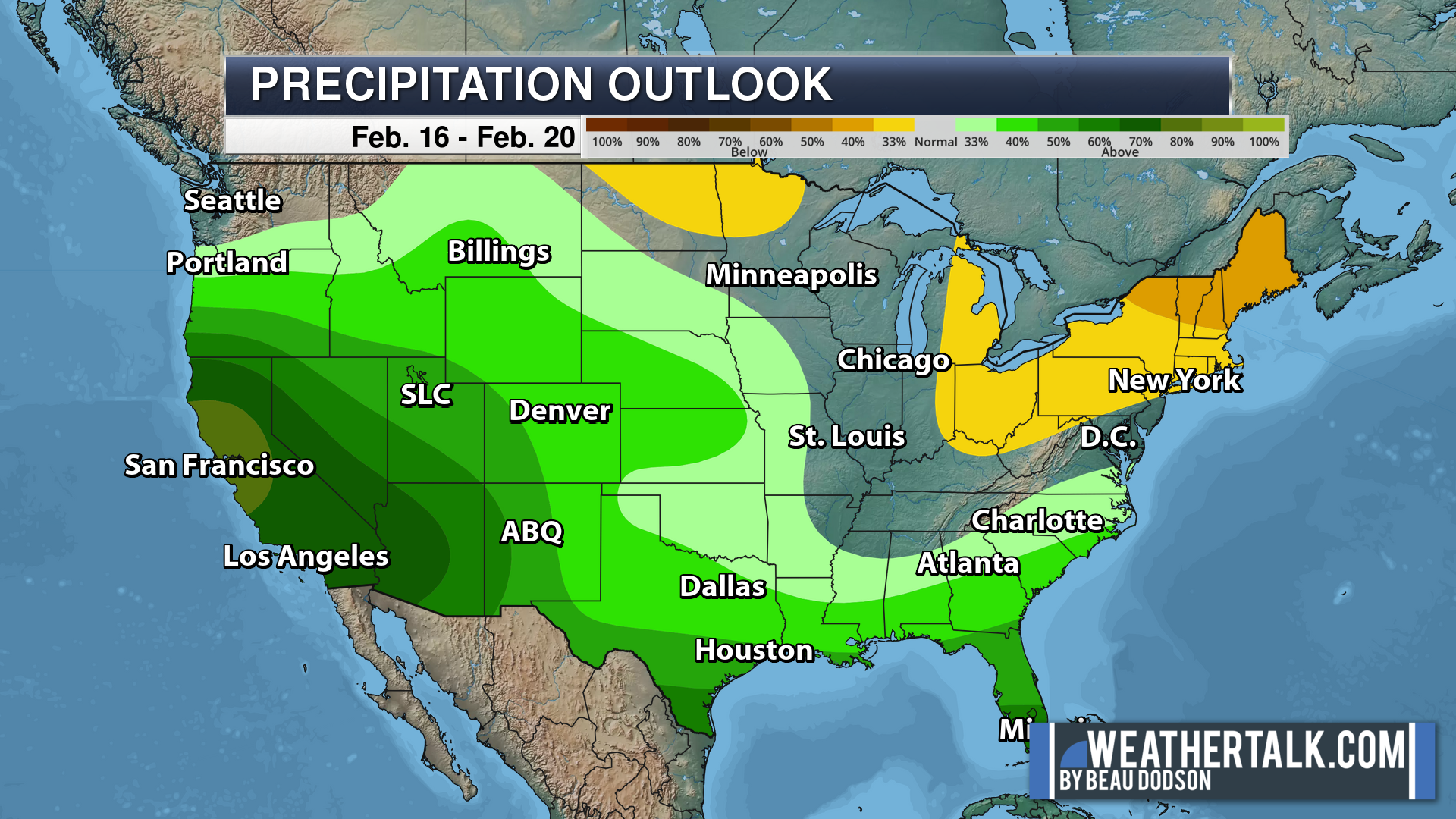
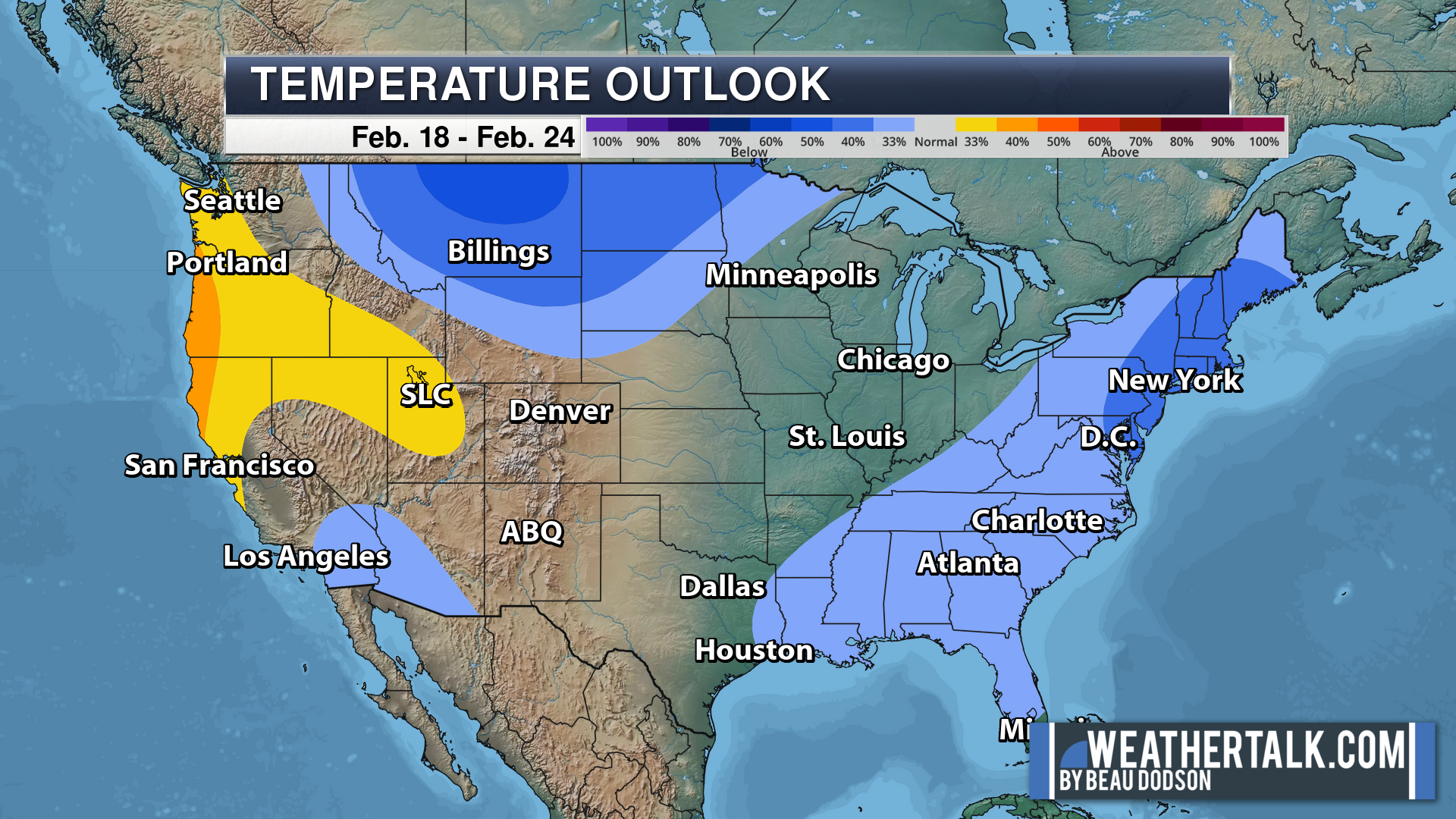
Six to Ten Day Outlook.
Blue is below average. Red is above average. The no color zone represents equal chances.
Average highs for this time of the year are in the lower 60s. Average lows for this time of the year are in the lower 40s.
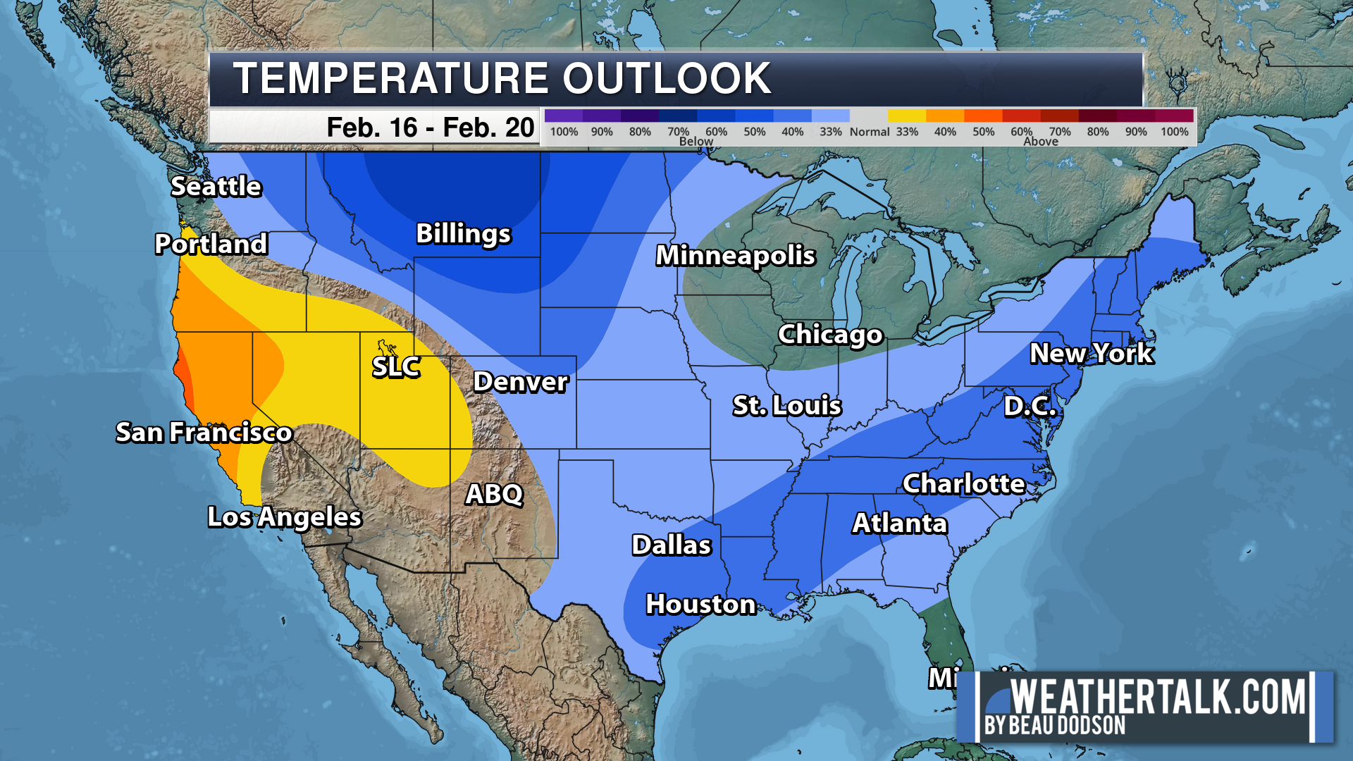
Green is above average precipitation. Yellow and brown favors below average precipitation. Average precipitation for this time of the year is around one inch per week.
.

Average low temperatures for this time of the year are around 29 degrees.
Average precipitation during this time period ranges from 0.50″ to 1.00″
.
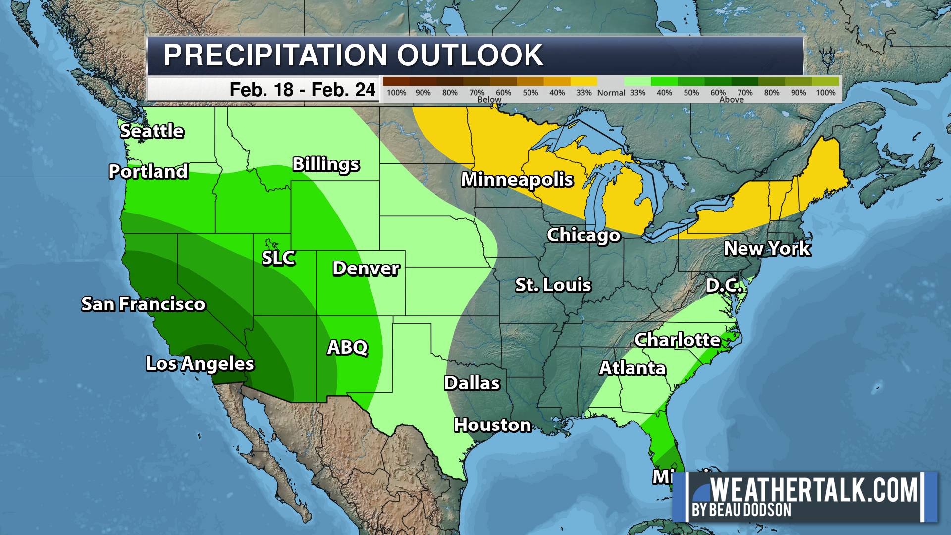
Eight to Fourteen Day Outlook.
Blue is below average. Red is above average. The no color zone represents equal chances.
Green is above average precipitation. Yellow and brown favors below average precipitation. Average precipitation for this time of the year is around one inch per week.
.
![]()
The app is for subscribers. Subscribe at www.weathertalk.com/welcome then go to your app store and search for WeatherTalk
Subscribers, PLEASE USE THE APP. ATT and Verizon are not reliable during severe weather. They are delaying text messages.
The app is under WeatherTalk in the app store.

Apple users click here

Android users click here
.

Radars and Lightning Data
Interactive-city-view radars. Clickable watches and warnings.
https://wtalk.co/B3XHASFZ
If the radar is not updating then try another one. If a radar does not appear to be refreshing then hit Ctrl F5. You may also try restarting your browser.
Backup radar site in case the above one is not working.
https://weathertalk.com/morani
Regional Radar
https://imagery.weathertalk.com/prx/RadarLoop.mp4
** NEW ** Zoom radar with chaser tracking abilities!
ZoomRadar
Lightning Data (zoom in and out of your local area)
https://wtalk.co/WJ3SN5UZ
Not working? Email me at beaudodson@usawx.com
National map of weather watches and warnings. Click here.
Storm Prediction Center. Click here.
Weather Prediction Center. Click here.
.

Live lightning data: Click here.
Real time lightning data (another one) https://map.blitzortung.org/#5.02/37.95/-86.99
Our new Zoom radar with storm chases
.
.

Interactive GOES R satellite. Track clouds. Click here.
GOES 16 slider tool. Click here.
College of DuPage satellites. Click here
.

Here are the latest local river stage forecast numbers Click Here.
Here are the latest lake stage forecast numbers for Kentucky Lake and Lake Barkley Click Here.
.
.
Find Beau on Facebook! Click the banner.


 .
.