
We have our first sponsor for the blog. Milner and Orr Funeral Home and Cremation Services located in Paducah, Kentucky and three other western Kentucky towns – at Milner and Orr they believe in families helping families.
![]()

This forecast update covers far southern Illinois, far southeast Missouri, and far western Kentucky. See the coverage map on the right side of the blog.
Remember that weather evolves. Check back frequently for updates, especially during active weather.
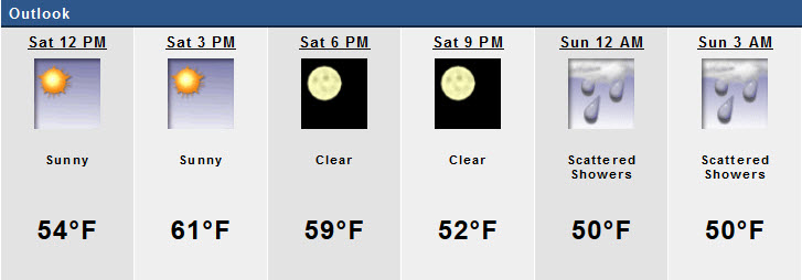
Saturday – Windy at times. A few clouds, otherwise a great day. Mild – spring like temperatures. Highs well into the 50’s by the afternoon. Maybe some 60’s if we reach full sunshine potential. Southwest winds at 10-25 mph – gusty. My confidence in this part of the forecast verifying is high
Morning School Bus Stop Weather – No school today. Chances of schools being delayed because of the weather 0%
—————————————————————————————-
Afternoon School Bus Stop Weather – No school today.
Saturday night – Becoming cloudy. A chance for drizzle or light rain showers. Scattered. Mild. Lows only in the upper 40’s to perhaps lower 50’s. Southwest winds at 10-15 mph with gusts above 20 mph. My confidence in this part of the forecast verifying is high
Sunday – Cloudy and mild. A few light rain showers possible. Highs in the 55-64 degree range. Southerly winds at 10-15 mph with gusts above 20 mph. My confidence in this part of the forecast verifying is medium
Sunday night – Cloudy. Cooler. Lows in the 30’s with winds becoming north/northwest at 10-15 mph. My confidence in this part of the forecast verifying is high
Monday – More clouds than sun. Colder. Gusty winds. Highs only in the upper 30’s to lower 40’s. North winds at 10-20 mph – gusty. My confidence in this part of the forecast verifying is medium

Current Temperatures Around The Local Area


An explanation of what is happening in the atmosphere over the coming days…
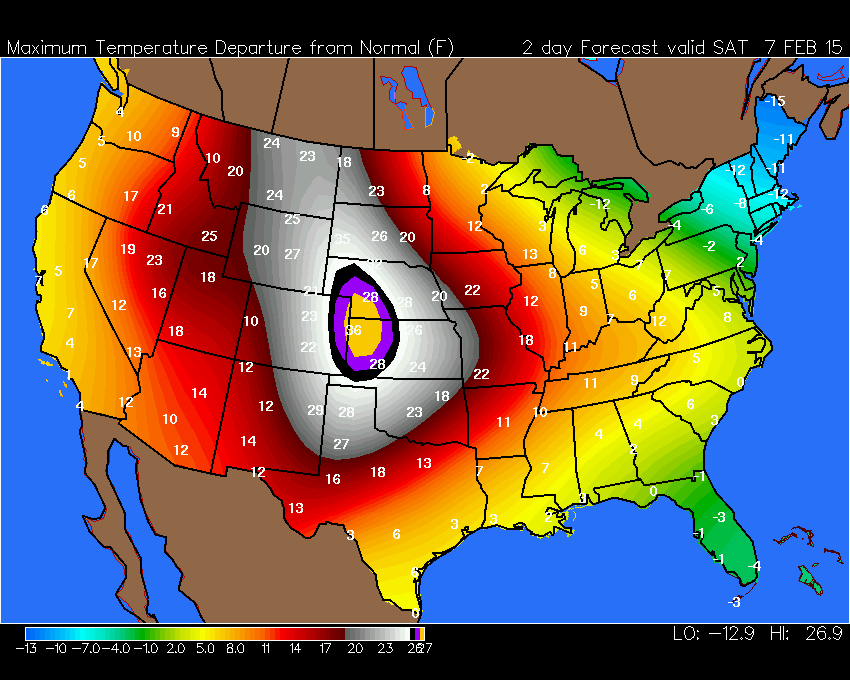
Well, WELCOME to the weekend! How about some WELL above normal temperatures for a change? If we can reach full sunshine today then everyone should reach into the 50’s! There is a chance for some lower 60’s both today and tomorrow.
Check out these high temperature anomalous for today. In other words, how much above normal will temperatures be?
Just look at those BIG BIG numbers out west! Not too shabby in our region either. Normal highs are in the middle 40’s for our local counties.
And, here is Sunday’s departures
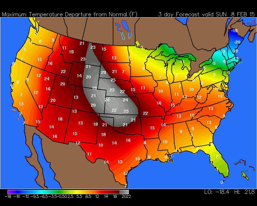
Sunday will bring some clouds. That is a concern for reaching maximum temperature potential. Also some light showers are possible tonight (Saturday night) and Sunday. Unfortunately, the clouds are going to make Sunday a bit gloomy.
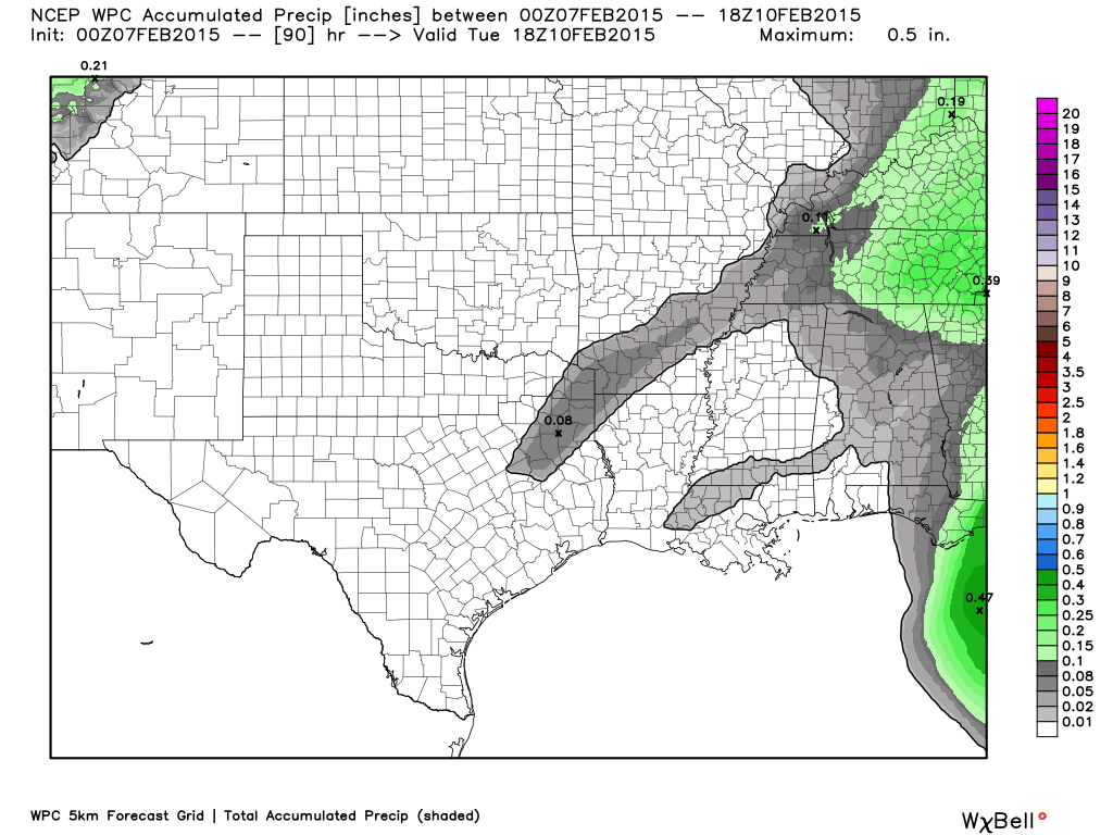
Rainfall totals will be on the light side (see rainfall totals graphic further down in the blog)
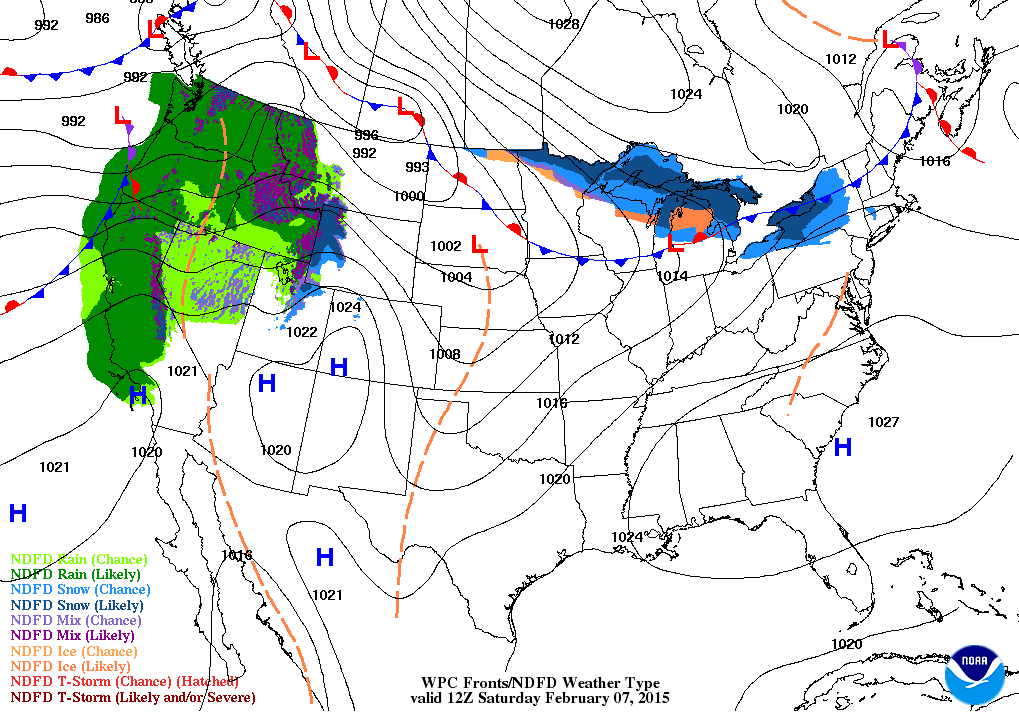
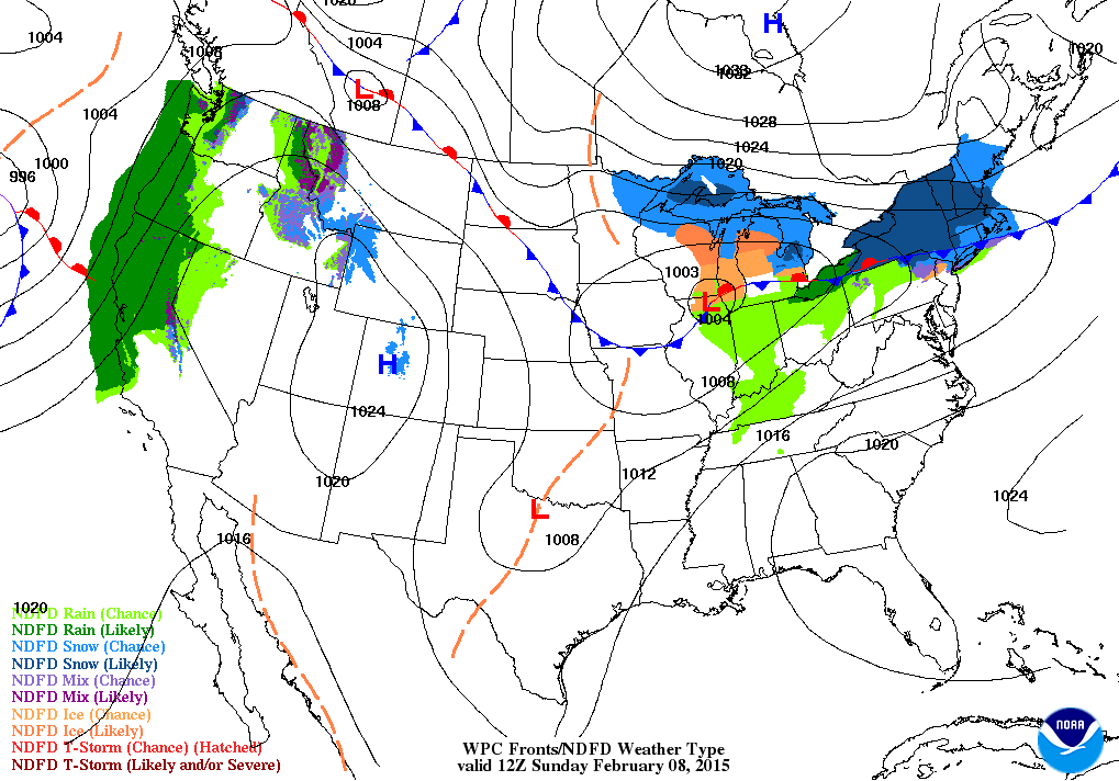
Here is the Saturday morning weather map and then Sunday (note the light green on Sunday – those are some patchy rain showers)
And here is Sunday’s weather map
See the area of low pressure passing over northern Illinois? With the front trailing from it? That will be responsible for some light rain in our region, as well. Nice southwest winds being pulled into that system to our north. But, as the system pulls off to the east we will see the winds shift around to the northwest. That means cold air will filter back into our region. You knew it could not last too long.
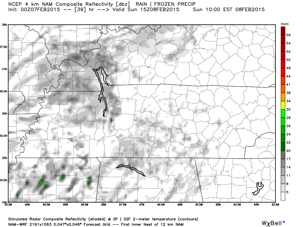
Let me zoom in on the future-cast radar for Sunday morning. See those gray patches? Those are drizzle and light rain showers. Obviously a lot of clouds, as well.
Winds this weekend…
Gusty winds will accompany this warm up (not uncommon for this time of the year). Some wind gusts today and tomorrow will reach 30 mph. If you are venturing out on the lake then keep that in mind. Not sure how many of you would venture out on the cold lake, but I know some of you are die hard boat fans!
All good things must come to an end. Colder temperatures arrive again on Sunday night and Monday. Not extreme…but colder.
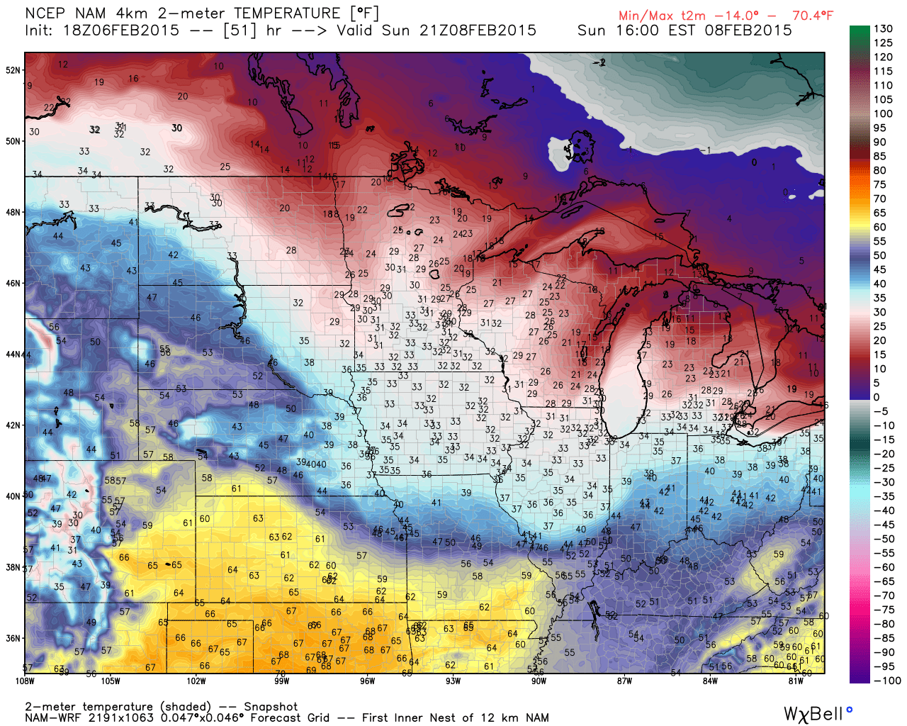
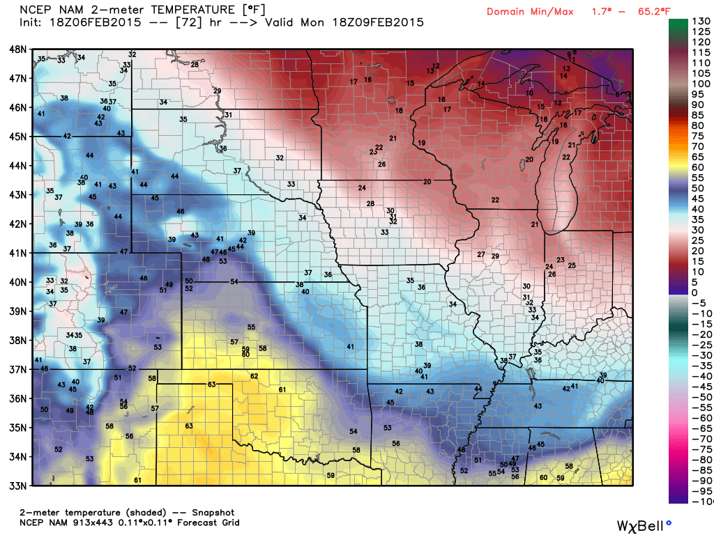
Let’s check that out – here are the Sunday afternoon temperatures. See those yellow and orange color? Those are 50’s and even 60’s! Nice! But, look to the north. Colder air is trying to nudge southward by Sunday afternoon (check central MO and central/northern IL)
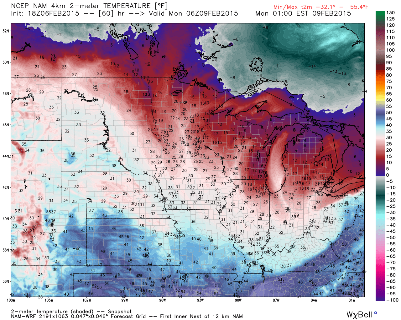
Now, the second image shows the cold air advancing southward on Sunday night. You can see that line through Kentucky and Tennessee
Click image for full size view – images from www.weatherbell.com
Now Sunday night temperatures…
Let’s pull ahead to Monday afternoon (around 11 am to 1 pm). See the colder air in our region? The warmer air has been pushed way back to the west.
I guess we are fortunate that the warm temperatures arrived for the weekend! At least it isn’t the middle of the week.
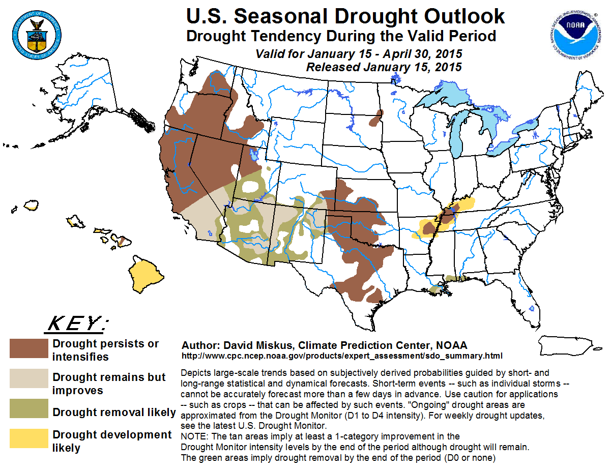
Drought conditions will worsen this week. I am concerned about the long range pattern. We need a serious adjustment in the overall pattern. These northwest flow events do not provide our moisture. Our moisture comes from the southwest flow events. That means we need the jet stream to come out of the southwest. There are small signals of that in the long range. A lot of NW flow continues to show up, however, for the next couple of weeks.
My winter forecast was dry and cool. The dry part has worked out well. December was above normal in the temperature department and January ended up below normal in the temperature department. We will have to see how February turns out in order to grade my winter forecast.
I didn’t go snowy and freaky cold…the almanacs sure did!
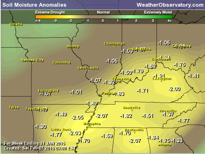
Soil moisture anomalies
The current drought forecast shows intensification of the drought is likely over portions of our region.
Click for larger view
I hope everyone enjoys the mild air…while it lasts. The extended part of the blog (see down below) is not as warm.
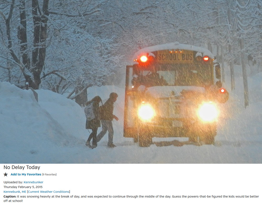
I know there are some big snow fans that visit this blog! So, here are a couple of photos I found on wunderground.com
You know how the kids always get out of school in our region for light snow? Well, maybe we need to tougher up a bit. Check this out – Maine! Beautiful snowfall with it sticking to the trees. More information on the photograph can be viewed here
And for good measure – I found this one on wunderground.com WOW – that is all I can say on this photograph! More information on the photograph can be found by clicking here
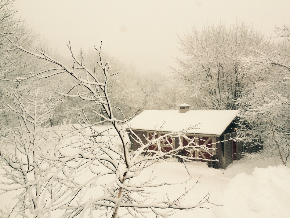
Steuben, Maine is the location
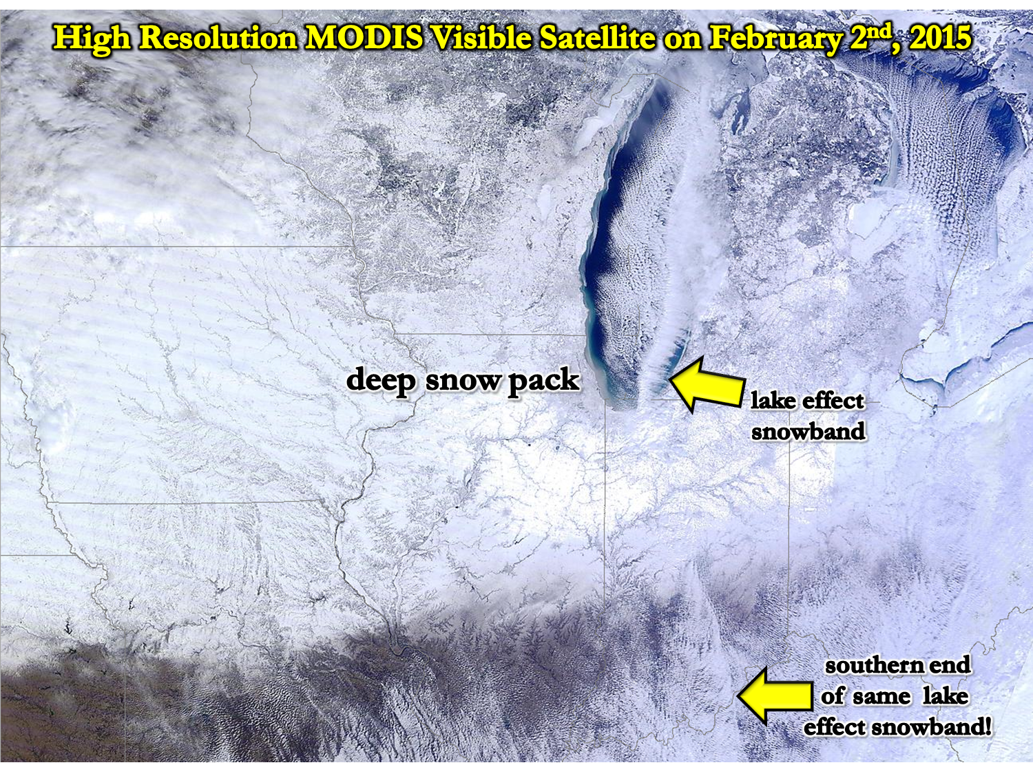
I know southern illinois has missed out on the snow this year. But, just to the north there has been a lot of snow over the past 2 weeks. Before that…not so much. It all hit at once. Same as the northeast United States. Most of the winter was boring – till the last 2 weeks.
I wonder if our region will find its way into a winter pattern as we move towards the middle and end of the month.
Here is a cool satellite photograph showing the deep snow pack to our north. Click image for large view.
Just how much snow fell up north? Well, since you asked 🙂 Click image for a larger view.
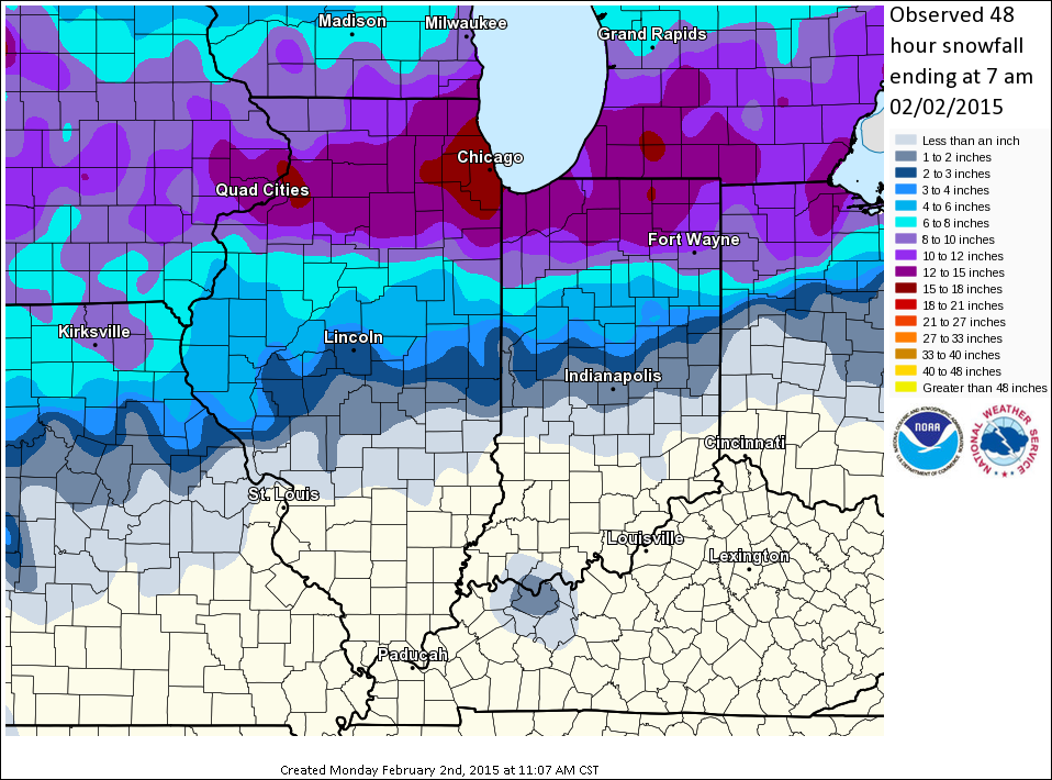
Yes, well – that is a LOT of snow. Keep hope alive snow lovers – winter is not quite over.
WANT TO HELP SUPPORT THIS BLOG AND COVER EXPENSES?
Did you know that the Weather Observatory is funded by people like you? I rely on ad’s on this blog and individual donations. PayPal also allows you to set up a monthly recurring donation. I have had several people give $5, $10, and $20 a month. A recurring donation helps keep the weather information flowing. If you enjoy this blog, the Twitter account, the Facebook interaction, the weather radars, and all of the other information then consider making a donation or setting up a recurring donation (if you don’t use PayPal then contact me through email about how you can mail a donation) beaudodson@usawx.com
Or mail a check to
Beau Dodson
3954 Mermet Road
Belknap, IL
62908
Thank you for your support!

No significant changes to the ongoing forecast.

No concerns today. Some gusty winds for boaters.
Check out our newest sponsors $5 meal! The DQ Grill and Chill (located across from Noble Park in Paducah, Kentucky) is the newest WeatherTalk Blog sponsor! A local business helping to sponsor the weather information that you have come to love so much.
They have a Facebook Page and I encourage you to check it out. DQ Grill and Chill on Facebook


The wild card tells you where the uncertainties are in the forecast
Wild card in this forecast – The wild card today is centered around some light rain and drizzle tonight and Sunday. The chances will be scattered, at best. But, some of you might see some drops on your windshields. Rainfall totals should be on the light side.
The second wild card is the high temperature on Sunday. It looks to me like there will be plenty of clouds on Sunday. So, that is going to keep temperatures a few degrees cooler than on Saturday. Still – 50’s will be the rule. If the sun were to come out then some 60 degree readings would occur. Either way it will be mild!

Can we expect severe thunderstorms over the next 24 to 48 hours? Remember that a severe thunderstorm is defined as a thunderstorm that produces 58 mph winds or higher, quarter size hail or larger, and/or a tornado.
Thunderstorm threat level is ZERO!

Speaking of severe weather. Check out these amazing hail photographs from Africa. Click image for larger view
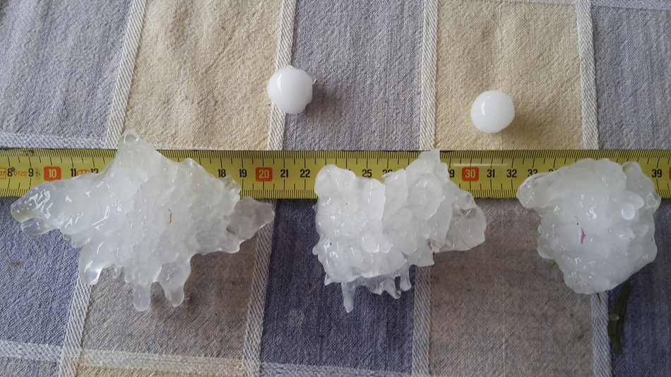
Pietermaritzburg, South Africa. Images are from Wunderground.com

Will I need to take action?
Maybe some light rain tonight and Sunday. Umbrella? Perhaps briefly.

How much precipitation should we expect over the next few days?
Some light rain possible Saturday night and Sunday/Sunday night. There are a few pockets of 0.10″ to maybe 0.20″ showing up on the map below. Mostly over far southern Illinois and western Kentucky. Most of that falls late Saturday night and Sunday.
We have a new sponsor! G&C Multi-Services out of Paducah, Kentucky. G & C Multi-Services is a service provider in Western Kentucky that provides industrial and commercial equipment fabrication, machine troubleshooting, repair and maintenance, and installation. They can custom fabricate steel, stainless, and aluminum products per customer specifications.
Visit their web-site here. Or click the ad below! They have a Facebook page and it can be viewed here.

Spring like weather today and tomorrow. Sorry snow fans! Check out the extended forecast for thoughts on the coming weeks (end of winter).

This section of the blog is speculative forecast information. Because it is past the range of what meteorologists can forecast accurately, it should be considered speculation. Anything past day 5 is considered a long range forecast.
I know the snow lovers keep coming back to the blog looking for a glimmer of hope. Something. Anything!
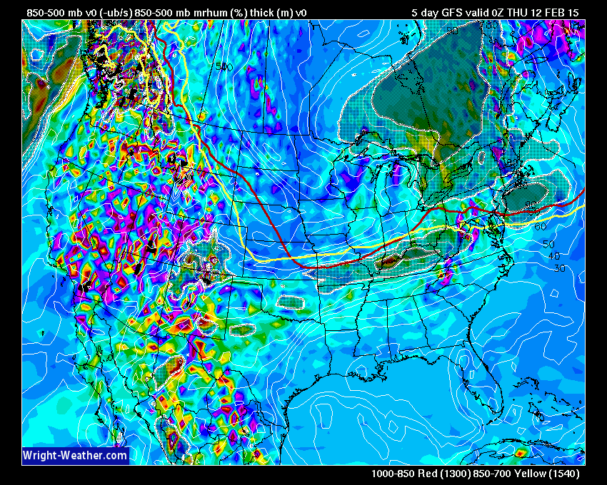
We have a weak front on Wednesday night or Thursday with light rain perhaps changing to light snow. Looks similar to the system we had earlier this past week. Light event. But, will monitor for any changes.
This is what that looks like on the GFS – Wednesday evening. Some higher relative humidity and some lift across our region from west to east. So, perhaps some light precipitation as the cold front shifts southward.
I can say that the middle and end of February looks more interesting than the last six weeks. But and however – isn’t there always a but and however – interesting does not necessarily mean that we can pull off a winter weather event. I am semi-optimistic though that the pattern does favor some wintry precipitation. It has been a long time since I have said that. It has just been that kind of winter (for snow lovers).
From February 15th onward – I see a couple of storm systems that could bring our region precipitation. There are no promises here. Just observing the overall pattern set-up.
At the very least let’s hope for rain. Eastern Arkansas is now in a pretty good drought. Western Kentucky and far southern Illinois remain in drought. We need some rain or snow or both.
So – bottom line – snow lovers…don’t give up. I see a pattern shift as we move past February 15th. Perhaps a more active pattern with a couple of storm systems to monitor for precipitation. Will that mean snow? Will that mean rain or thunderstorms? Too far out. I am just letting you know it appears it might become more active.
There are a lot of signs in the charts of northwest flow. Normally northwest flow brings small weather systems into our region (clippers we call them). Those usually bring snow to our north. Occasionally one will dive far enough south for our region to experience some snow or rain.
There are some signs, however, that we may see a couple of storm systems come out of the southwest United States. These are the ones we need to monitor for significant precipitation in our region or the southern United States.
If one can pull out of the southwest then it would be game on for precipitation in this region and the southern U.S.
I don’t like to go out on a limb on the long-range….but
The battle lines between the cold and warm appear to be lining up as we move into next week and the following week (into the end of the month). As you know…if you have followed me for awhile, you want to be near the battle line of the cold and warm. If you like active weather that is. So, if you want snow or rain you want to be in the battle zone.
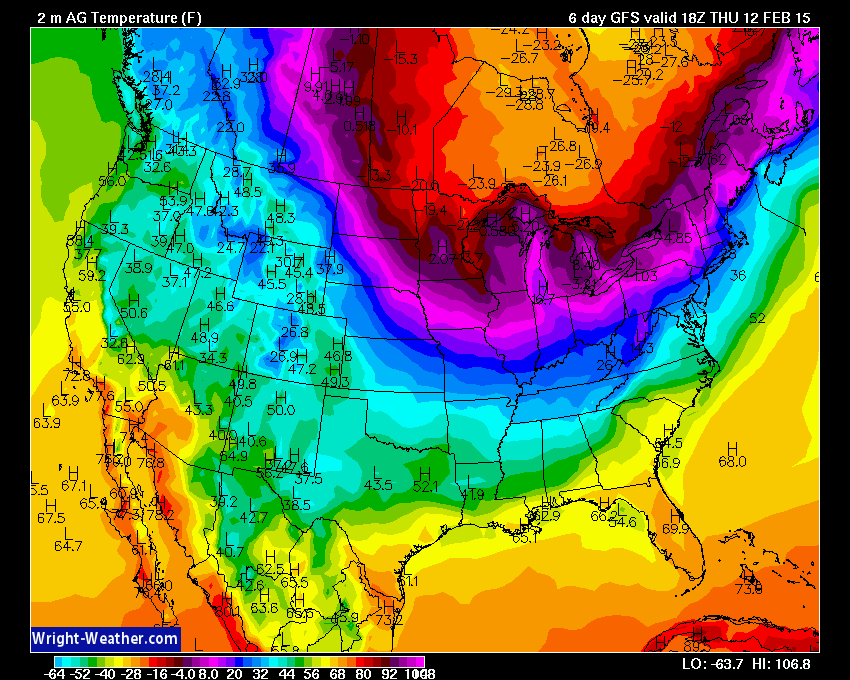
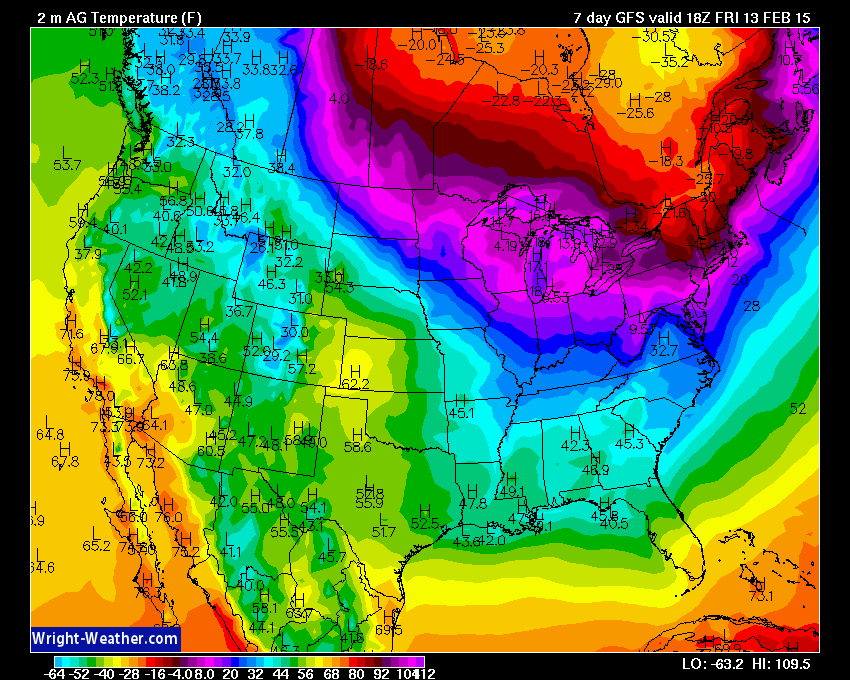
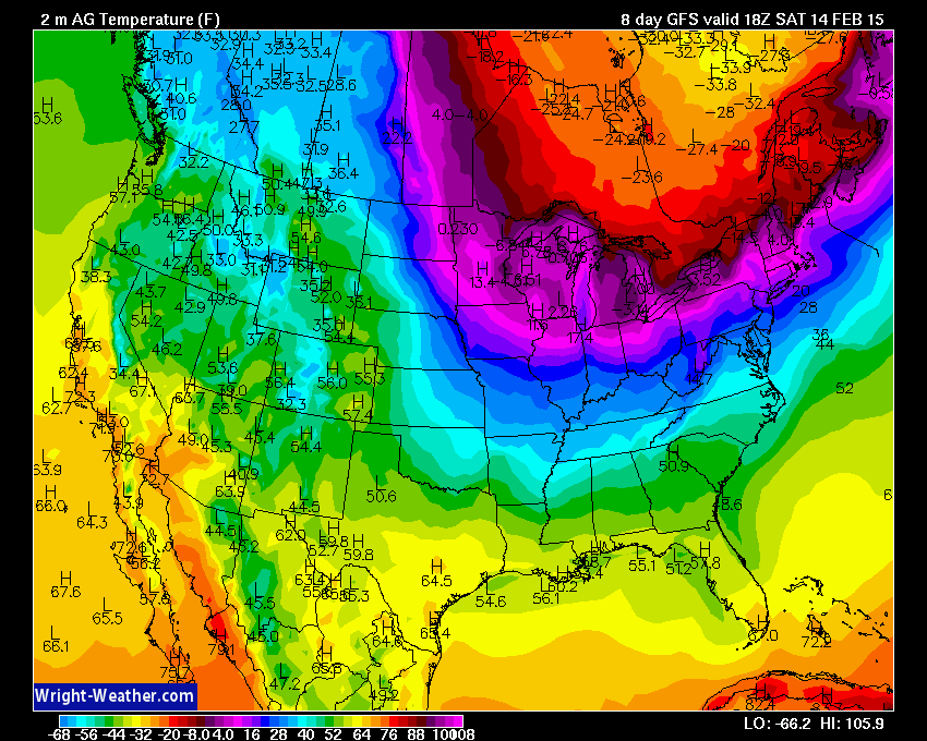
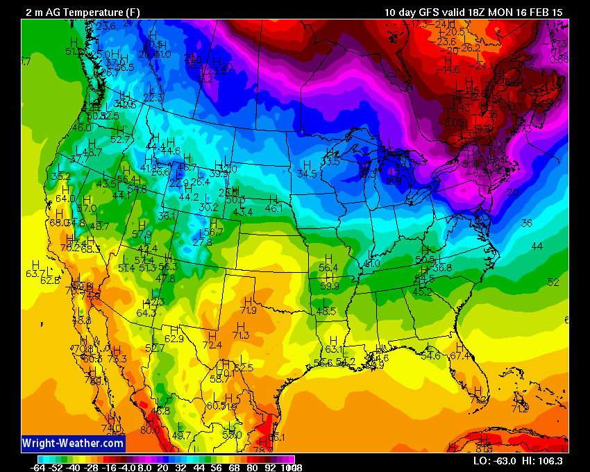
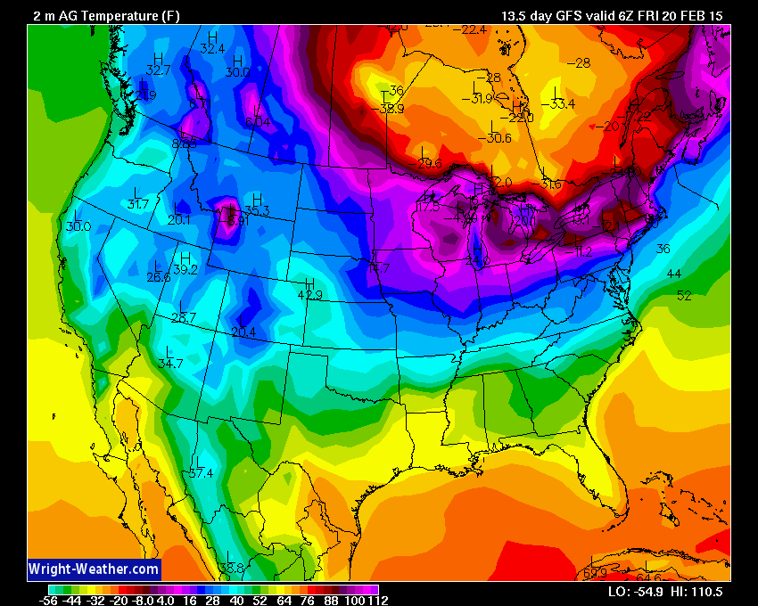
The tug and war between the cold and warm air is obvious in these temperature maps below (check the data on each one – afternoon high temperatures).
Images are from www.wright-weather.com
Next Wednesday afternoon
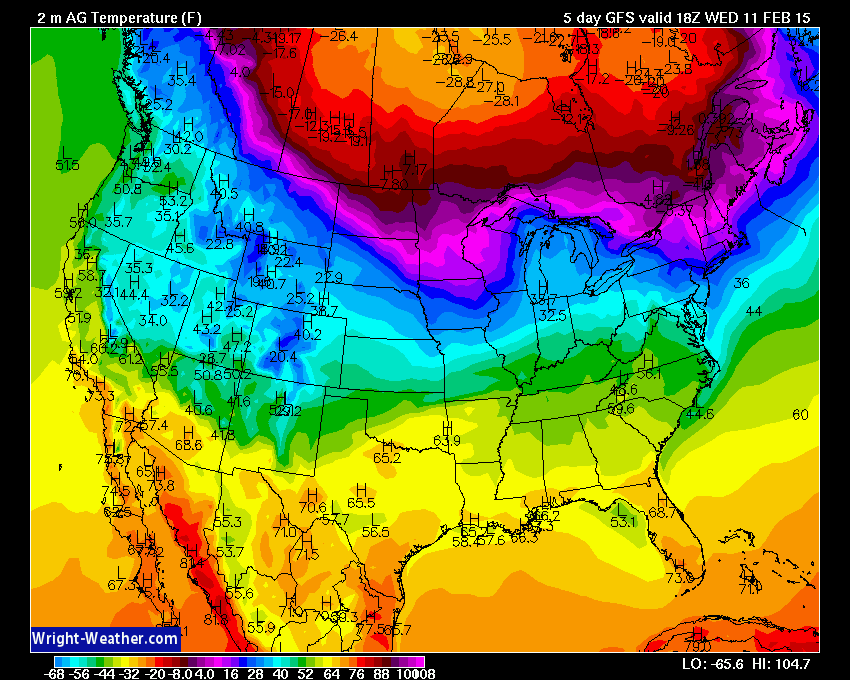
Next Thursday afternoon (below)
Next Friday afternoon (below)
Next Saturday afternoon (below)
Next Sunday afternoon

Next Monday afternoon (below)
Next Tuesday afternoon
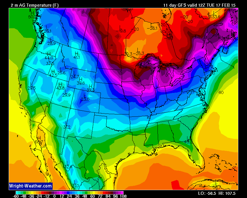
Friday the 20th – this is a see/saw pattern. Up and down.
Let me show you this massive area of high pressure that attempts to build southward into our area next week. 1055 mb over the Canada/U.S. Border. That is one big high! The colors represent how many degrees below normal temperatures are forecast to be at the same time the high moves in.
Big high pressure system from Canada in the winter months mean cold temperatures for our region. These two images are from weatherbell.com
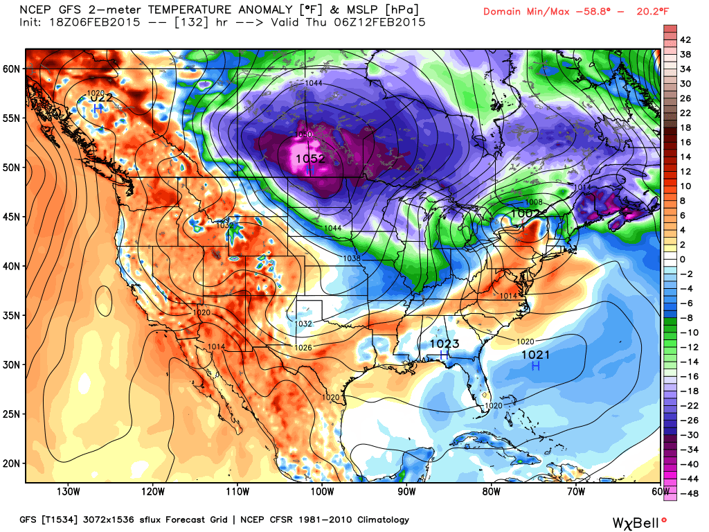
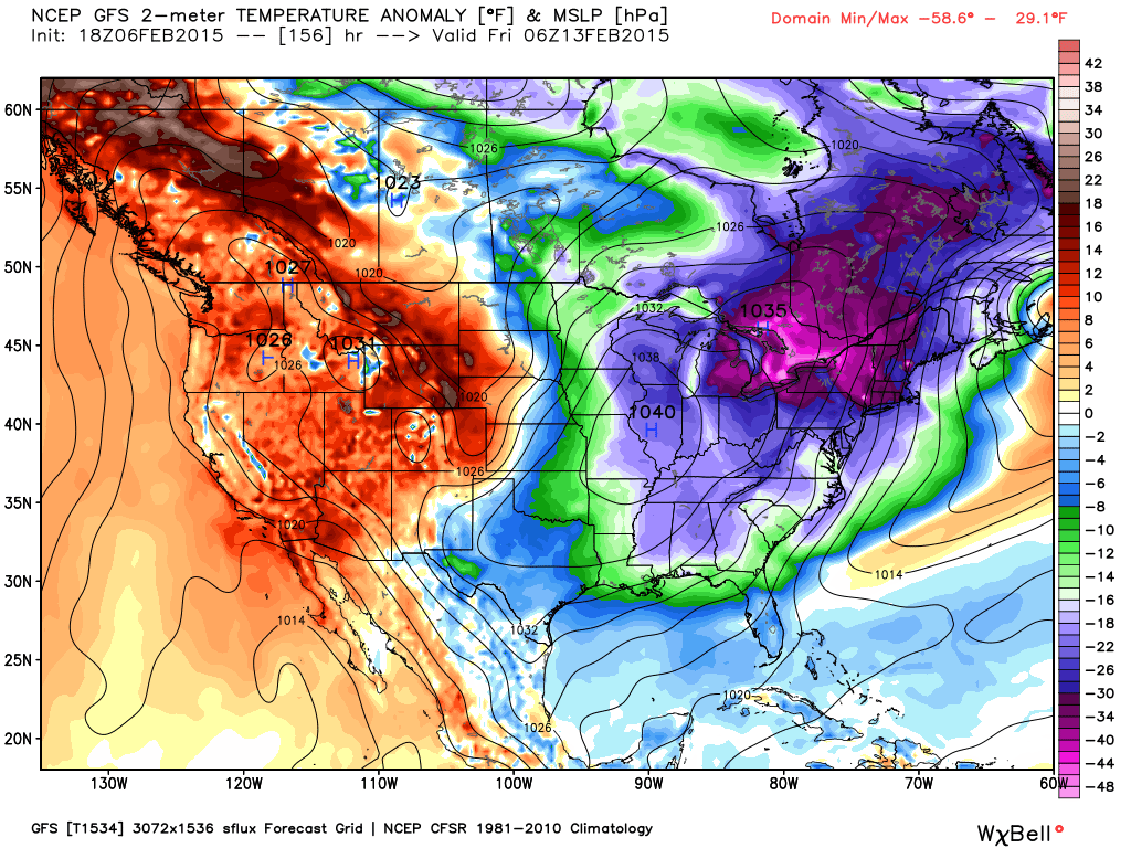
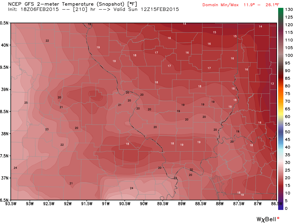
You can see the high weakens somewhat as it moves over our local area. Still, impressive. The center of the coldest air shifts over the Great Lakes and northeast. But, still – colder than normal in our region by a good 15-25 degrees.
What would that mean temperature wise? Highs in the 20’s low in the teens. Chilly
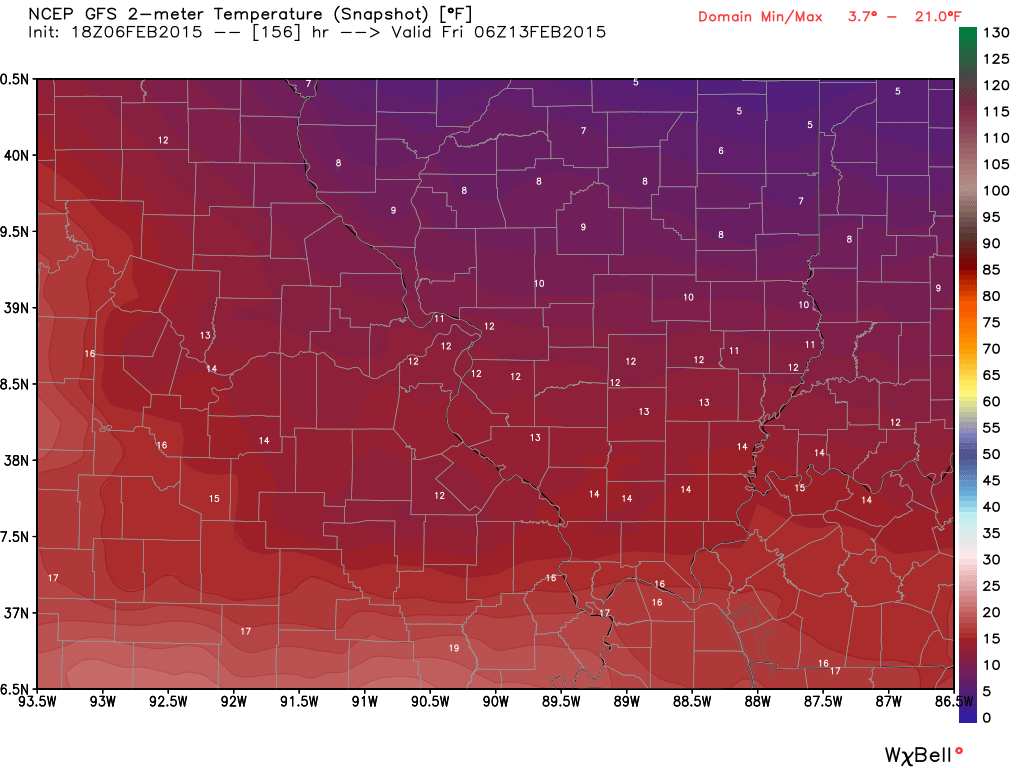
Let’s keep an eye on the big high pressure diving southward later this week. See how cold temperatures can drop as it moves over our area.
Here is the GFS model’s forecast for temperatures on Friday night. Looks about right if that big high actually does push over our region. It would be quite cold.
You can see single digits further north. Maps are from weatherbell.com
Click image for larger views
Sunday’s temperature map (morning). Some teens in the region.

Who do you trust for your weather information and who holds them accountable?
I have studied weather in our region since the late 1970’s. I have 37 years of experience in observing our regions weather patterns. My degree is in Broadcast Meteorology from Mississippi State University and an Associate of Science (AS). I am currently working on my Bachelor’s Degree in Geoscience. Just need to finish two Spanish classes!
I am a member of the American Meteorological Society. I am a NOAA Weather-Ready Nation Ambassador. And, I am the Meteorologist for McCracken County Emergency Management.
I own and operate the Southern Illinois Weather Observatory.
There is a lot of noise on the internet. A lot of weather maps are posted without explanation. Over time you should learn who to trust for your weather information.
My forecast philosophy is simple and straight forward.
- Communicate in simple terms
- To be as accurate as possible within a reasonable time frame before an event
- Interact with you on Twitter, Facebook, and the blog
- Minimize the “hype” that you might see on television or through other weather sources
- Push you towards utilizing wall-to-wall LOCAL TV coverage during severe weather events
I am a recipient of the Mark Trail Award, WPSD Six Who Make A Difference Award, Kentucky Colonel, and the Caesar J. Fiamma” Award from the American Red Cross. In 2009 I was presented with the Kentucky Office of Highway Safety Award. I was recognized by the Kentucky House of Representatives for my service to the State of Kentucky leading up to several winter storms and severe weather outbreaks.
If you click on the image below you can read the Kentucky House of Representatives Resolution.

I am also President of the Shadow Angel Foundation which serves portions of western Kentucky and southern Illinois.

We have regional radars and local city radars – if a radar does not seem to be updating then try another one. Occasional browsers need their cache cleared. You may also try restarting your browser. That usually fixes the problem. Occasionally we do have a radar go down. That is why I have duplicates. Thus, if one fails then try another one.
If you have any problems then please send me an email beaudodson@usawx.com
WEATHER RADAR PAGE – Click here —
We also have a new national interactive radar – you can view that radar by clicking here.
Local interactive city radars include St Louis, Mt Vernon, Evansville, Poplar Bluff, Cape Girardeau, Marion, Paducah, Hopkinsville, Memphis, Nashville, Dyersburg, and all of eastern Kentucky – these are interactive radars. Local city radars – click here
NOTE: Occasionally you will see ground clutter on the radar (these are false echoes). Normally they show up close to the radar sites – including Paducah.

Regional Radar – Click on radar to take you our full radar page.


Regional Radar
![]()
Current WARNINGS (a warning means take action now). Click on your county to drill down to the latest warning information. Keep in mind that there can be a 2-3 minute delay in the updated warning information.
I strongly encourage you to use a NOAA Weather Radio or warning cell phone app for the most up to date warning information. Nothing is faster than a NOAA weather radio.


Color shaded counties are under some type of watch, warning, advisory, or special weather statement. Click your county to view the latest information.

Missouri Warnings

Illinois Warnings

Kentucky Warnings

Please visit your local National Weather Service Office by clicking here. The National Weather Service Office, for our region, is located in Paducah, Kentucky. They have a lot of maps and information on their site. Local people…local forecasters who care about our region.


Here is the official 6-10 day and 8-14 day temperature and precipitation outlook. Check the date stamp at the top of each image (so you understand the time frame).
The forecast maps below are issued by the Weather Prediction Center (NOAA).


The latest 8-14 day temperature and precipitation outlook. Note the dates are at the top of the image. These maps DO NOT tell you how high or low temperatures or precipitation will be. They simply give you the probability as to whether temperatures or precipitation will be above or below normal.


Many of my graphics are from www.weatherbell.com – a great resource for weather data, model data, and more


This blog was inspired by ABC 33/40’s Alabama Weather Blog – view their blog
Current tower cam view from the Weather Observatory- Click here for all cameras.

Southern Illinois Weather Observatory

The Weather Observatory

Southern Illinois Weather Observatory
WSIL TV 3 has a number of tower cameras. Click here for their tower camera page & Illinois Road Conditions

Marion, Illinois
WPSD TV 6 has a number of tower cameras. Click here for their tower camera page & Kentucky Road Conditions & Kentucky Highway and Interstate Cameras

Downtown Paducah, Kentucky
Benton, Kentucky Tower Camera – Click here for full view

Benton, Kentucky

I24 Paducah, Kentucky

I24 Mile Point 9 – Paducah, KY

I24 – Mile Point 3 Paducah, Kentucky

You can sign up for my AWARE email by clicking here I typically send out AWARE emails before severe weather, winter storms, or other active weather situations. I do not email watches or warnings. The emails are a basic “heads up” concerning incoming weather conditions.