We have our first sponsor for the blog. Milner and Orr Funeral Home and Cremation Services located in Paducah, Kentucky and three other western Kentucky towns – at Milner and Orr they believe in families helping families.
![]()

This forecast update covers far southern Illinois, far southeast Missouri, and far western Kentucky. See the coverage map on the right side of the blog.
Remember that weather evolves. Check back frequently for updates, especially during active weather.
Friday – Partly cloudy and cold. Highs in the 40’s. Southwest winds at 10 mph. My confidence in this part of the forecast verifying is high
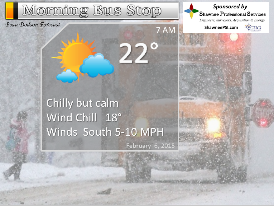
Morning School Bus Stop Weather – A chilly start again to the morning with temperatures in the upper teens and lower 20’s. Chances of schools being delayed because of the weather 0%
—————————————————————————————-
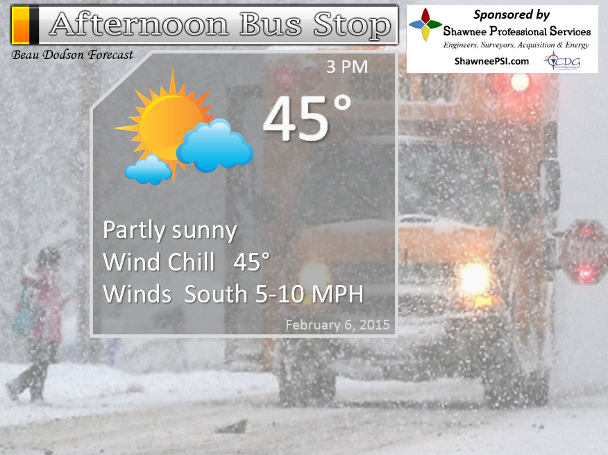
Afternoon School Bus Stop Weather – Partly sunny and cool with temperatures only in the 40’s.
Friday night – Partly cloudy…not quite as cold. Lows in the 28 to 35 degree range. Not too bad for February. Southerly winds at 10-15 mph. My confidence in this part of the forecast verifying is high
Saturday – Windy. A mix of sun and clouds. Milder. Highs well into the 50’s! Southerly winds at 10-20 mph – gusty at times. My confidence in this part of the forecast verifying is medium
Saturday night – Cloudy. Slight chance for a light shower. Lows in the 40’s. Southerly winds at 10-15 mph. My confidence in this part of the forecast verifying is medium
Sunday – Cloudy with a light shower possible. Mild! Highs will be in the 55 to 62 degree range. Southwest winds at 10-20 mph. My confidence in this part of the forecast verifying is medium

The School Bus Stop Forecast is brought to your by Shawnee Professional Services. For more information click here
Shawnee Professional Services & Civil Design Group have been providing Land Surveying, Engineering, Grant Administration and Acquisition services for the past 20 years.
Currently Licensed in Illinois, Kentucky, Missouri, Indiana, and Tennessee; please contact Shawnee for any Land Surveying or Engineering needs.
Shawnee’s company size allows them to devote individual attention to each client and to approach each project with the required thoroughness to successfully complete the project, large or small.
Shawnee combines innovative thinking and proven techniques, completing projects cost-effectively for their clients. Visit Shawnee’s website at shawneepsi.com for more information. Shawnee has offices in Paducah, KY, Vienna, IL and Benton, IL.
Current Temperatures Around The Local Area


An explanation of what is happening in the atmosphere over the coming days…
Another cool day for the region, But, as you know – this is not going to last! MUCH milder air arrives on Saturday and Sunday. Now, they may be some clouds with the milder air. There is also a chance for some light showers on Saturday night into Sunday night as a weak weather system passes to our north and east. But, overall the weather won’t be too bad. Especially true since it is early February.
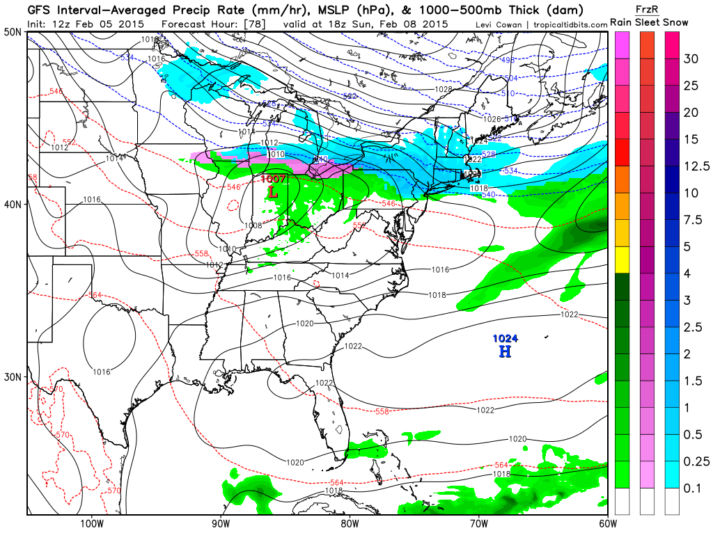
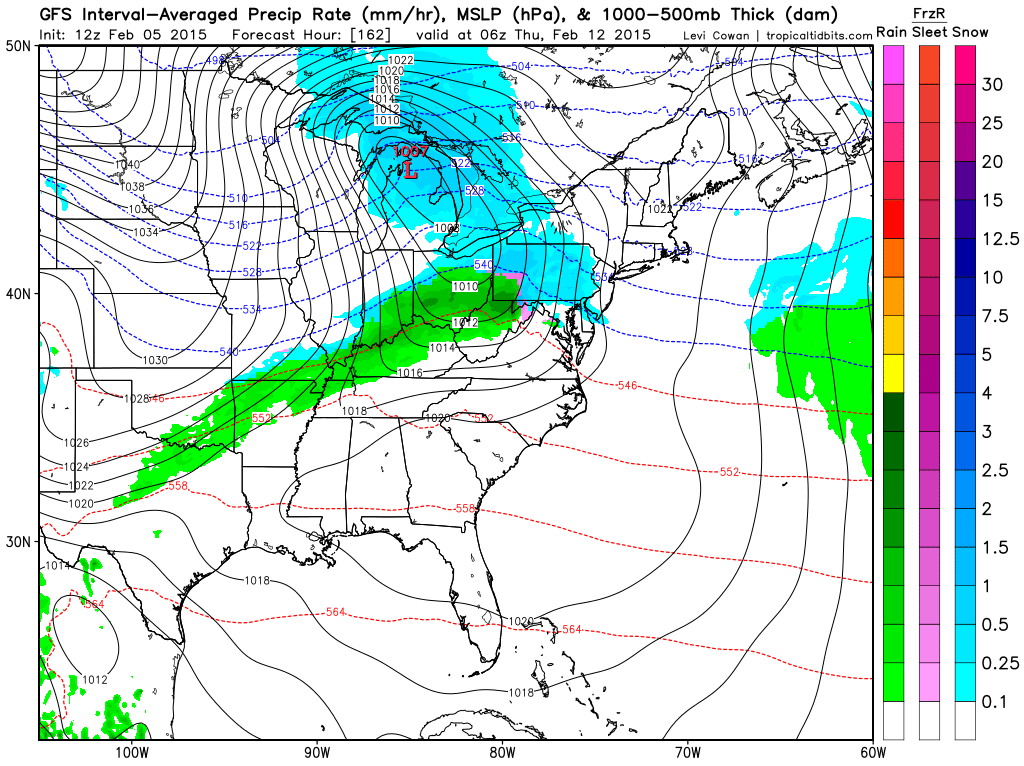
Here is that weak system on Saturday night into Sunday. Maybe some light showers in our region. Not expecting much and the chances are scattered at best.
Highs today will top out in the 40’s. Bearable.
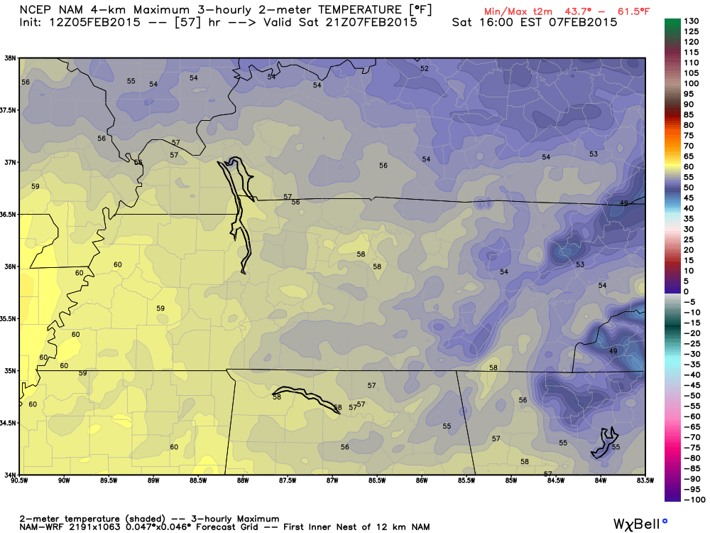
Highs on Saturday will reach well into the 50’s and maybe some spots will reach 60 degrees. Some debate, again, on cloud cover. IF we can pull off full sunshine then 60 will be a possibility. Cross fingers and toes!
Here is the high resolution NAM model’s high temperature forecast
Here is the weather map for Friday and Saturday. Fairly calm for our region with high pressure in charge on Friday. That high moves off to the east/southeast on Saturday. That will help milder air push into our region. When high pressure moves off to our east that means southerly winds return to our region. The air around high pressure rotates in a clockwise fashion.
That milder air may mean some increase in clouds.
I am not tracking any snowstorms. So, if you are looking for additional snowflakes you will have to keep checking back.
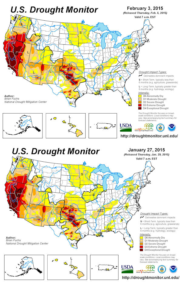
The new drought monitor is out. The drought has strengthened over portions of the region. In particular eastern Arkansas.

WANT TO HELP SUPPORT THIS BLOG AND COVER EXPENSES?
Did you know that the Weather Observatory is funded by people like you? I rely on ad’s on this blog and individual donations. PayPal also allows you to set up a monthly recurring donation. I have had several people give $5, $10, and $20 a month. A recurring donation helps keep the weather information flowing. If you enjoy this blog, the Twitter account, the Facebook interaction, the weather radars, and all of the other information then consider making a donation or setting up a recurring donation (if you don’t use PayPal then contact me through email about how you can mail a donation) beaudodson@usawx.com
Or mail a check to
Beau Dodson
3954 Mermet Road
Belknap, IL
62908
Thank you for your support!

I am wrestling with the amount of cloud cover on Saturday. I left my forecast along for now. Some increase in clouds possible on Saturday.

No major concerns. A nice weather alert for Saturday 🙂 – might be some clouds, but temperatures will be nice.
Check out our newest sponsors $5 meal! The DQ Grill and Chill (located across from Noble Park in Paducah, Kentucky) is the newest WeatherTalk Blog sponsor! A local business helping to sponsor the weather information that you have come to love so much.
They have a Facebook Page and I encourage you to check it out. DQ Grill and Chill on Facebook


The wild card tells you where the uncertainties are in the forecast
Wild card in this forecast – The wild card today centers around the chance for increasing clouds on Saturday. As warmer air spreads into the region there might be some clouds. That is fairly typical for this time of the year. Crossing fingers it won’t be mostly cloudy. It sure would be nice to have temperatures in the 50’s with some sun. The sun angle is growing higher and that feels great.

Can we expect severe thunderstorms over the next 24 to 48 hours? Remember that a severe thunderstorm is defined as a thunderstorm that produces 58 mph winds or higher, quarter size hail or larger, and/or a tornado.
Thunderstorm threat level is ZERO!


Will I need to take action?
No action required!

How much precipitation should we expect over the next few days?
No precipitation on Friday.
Some light rain possible Saturday night and Sunday/Sunday night. Maybe a trace to 0.05″. Does not look like much. Again.
We have a new sponsor! G&C Multi-Services out of Paducah, Kentucky. G & C Multi-Services is a service provider in Western Kentucky that provides industrial and commercial equipment fabrication, machine troubleshooting, repair and maintenance, and installation. They can custom fabricate steel, stainless, and aluminum products per customer specifications.
Visit their web-site here. Or click the ad below! They have a Facebook page and it can be viewed here.

No winter weather. Again. Should we just put that on rinse and repeat? Seems like it!

This section of the blog is speculative forecast information. Because it is past the range of what meteorologists can forecast accurately, it should be considered speculation. Anything past day 5 is considered a long range forecast.
Sort of a boring weather pattern. Not much in the long range to monitor. There are some signs of another cold shot towards the middle and end of next week. I will post the GFS model’s ideas on this (morning lows only – so keep that in mind)
A cold front on Wednesday or Thursday might bring another round of light rain or light snow. You can see that front here on this GFS model weather map for next Wednesday night. Looks familiar? About like the one that moved through on Wednesday night with light rain changing to light snow.
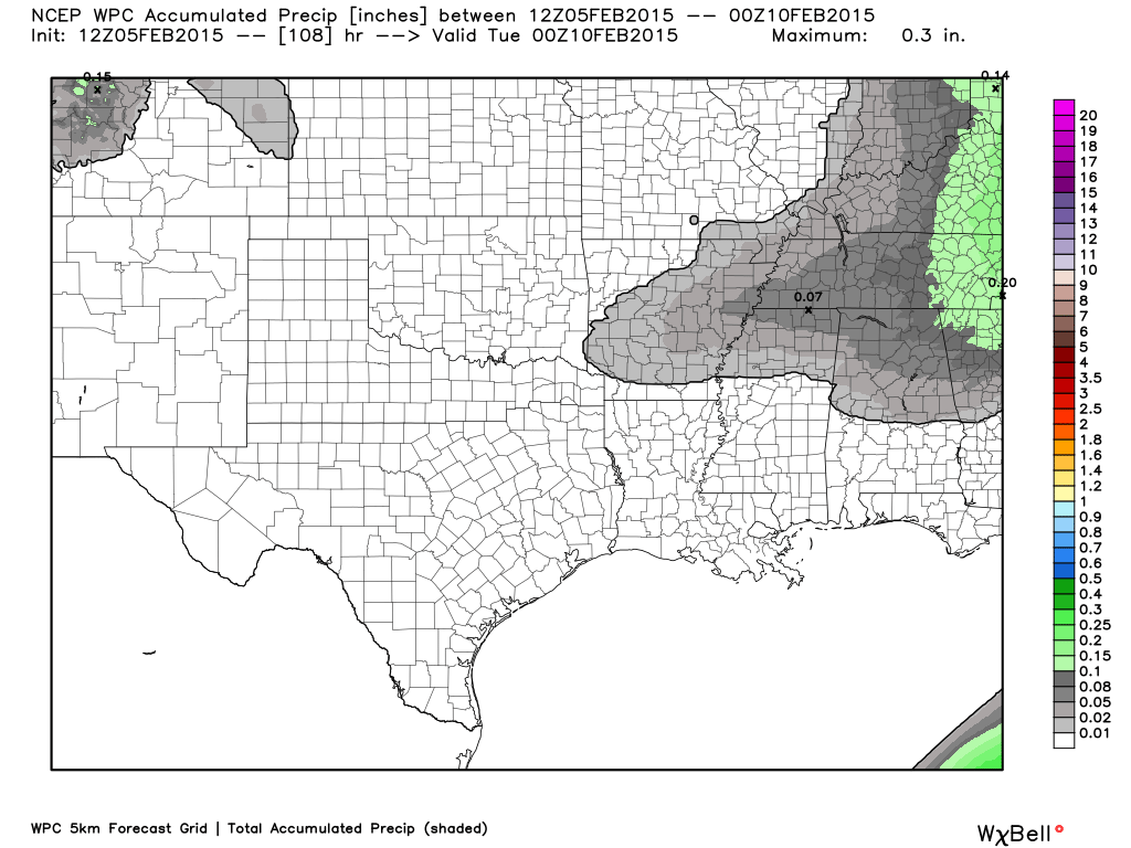
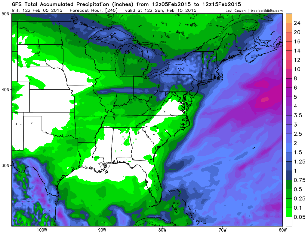
Here is the GFS models rainfall forecast through next Sunday. That is not much precipitation. The drought is going to grow worse over the coming weeks if this pattern does not change.
Here are the morning low temperatures forecasts for next week.
Tuesday morning lows
Wednesday morning lows
Thursday morning lows
Friday morning lows
Saturday morning lows
All in all it really does not look that bad. Yes, some cold shots of air. Maybe a cold front with another round of light rain or snow towards the middle of next week.
Yawn!

Who do you trust for your weather information and who holds them accountable?
I have studied weather in our region since the late 1970’s. I have 37 years of experience in observing our regions weather patterns. My degree is in Broadcast Meteorology from Mississippi State University and an Associate of Science (AS). I am currently working on my Bachelor’s Degree in Geoscience. Just need to finish two Spanish classes!
I am a member of the American Meteorological Society. I am a NOAA Weather-Ready Nation Ambassador. And, I am the Meteorologist for McCracken County Emergency Management.
I own and operate the Southern Illinois Weather Observatory.
There is a lot of noise on the internet. A lot of weather maps are posted without explanation. Over time you should learn who to trust for your weather information.
My forecast philosophy is simple and straight forward.
- Communicate in simple terms
- To be as accurate as possible within a reasonable time frame before an event
- Interact with you on Twitter, Facebook, and the blog
- Minimize the “hype” that you might see on television or through other weather sources
- Push you towards utilizing wall-to-wall LOCAL TV coverage during severe weather events
I am a recipient of the Mark Trail Award, WPSD Six Who Make A Difference Award, Kentucky Colonel, and the Caesar J. Fiamma” Award from the American Red Cross. In 2009 I was presented with the Kentucky Office of Highway Safety Award. I was recognized by the Kentucky House of Representatives for my service to the State of Kentucky leading up to several winter storms and severe weather outbreaks.
If you click on the image below you can read the Kentucky House of Representatives Resolution.

I am also President of the Shadow Angel Foundation which serves portions of western Kentucky and southern Illinois.

We have regional radars and local city radars – if a radar does not seem to be updating then try another one. Occasional browsers need their cache cleared. You may also try restarting your browser. That usually fixes the problem. Occasionally we do have a radar go down. That is why I have duplicates. Thus, if one fails then try another one.
If you have any problems then please send me an email beaudodson@usawx.com
WEATHER RADAR PAGE – Click here —
We also have a new national interactive radar – you can view that radar by clicking here.
Local interactive city radars include St Louis, Mt Vernon, Evansville, Poplar Bluff, Cape Girardeau, Marion, Paducah, Hopkinsville, Memphis, Nashville, Dyersburg, and all of eastern Kentucky – these are interactive radars. Local city radars – click here
NOTE: Occasionally you will see ground clutter on the radar (these are false echoes). Normally they show up close to the radar sites – including Paducah.

Regional Radar – Click on radar to take you our full radar page.


Regional Radar
![]()
Current WARNINGS (a warning means take action now). Click on your county to drill down to the latest warning information. Keep in mind that there can be a 2-3 minute delay in the updated warning information.
I strongly encourage you to use a NOAA Weather Radio or warning cell phone app for the most up to date warning information. Nothing is faster than a NOAA weather radio.


Color shaded counties are under some type of watch, warning, advisory, or special weather statement. Click your county to view the latest information.

Missouri Warnings

Illinois Warnings

Kentucky Warnings

Please visit your local National Weather Service Office by clicking here. The National Weather Service Office, for our region, is located in Paducah, Kentucky. They have a lot of maps and information on their site. Local people…local forecasters who care about our region.


Here is the official 6-10 day and 8-14 day temperature and precipitation outlook. Check the date stamp at the top of each image (so you understand the time frame).
The forecast maps below are issued by the Weather Prediction Center (NOAA).


The latest 8-14 day temperature and precipitation outlook. Note the dates are at the top of the image. These maps DO NOT tell you how high or low temperatures or precipitation will be. They simply give you the probability as to whether temperatures or precipitation will be above or below normal.


Many of my graphics are from www.weatherbell.com – a great resource for weather data, model data, and more


This blog was inspired by ABC 33/40’s Alabama Weather Blog – view their blog
Current tower cam view from the Weather Observatory- Click here for all cameras.

Southern Illinois Weather Observatory

The Weather Observatory

Southern Illinois Weather Observatory
WSIL TV 3 has a number of tower cameras. Click here for their tower camera page & Illinois Road Conditions

Marion, Illinois
WPSD TV 6 has a number of tower cameras. Click here for their tower camera page & Kentucky Road Conditions & Kentucky Highway and Interstate Cameras

Downtown Paducah, Kentucky
Benton, Kentucky Tower Camera – Click here for full view

Benton, Kentucky

I24 Paducah, Kentucky

I24 Mile Point 9 – Paducah, KY

I24 – Mile Point 3 Paducah, Kentucky

You can sign up for my AWARE email by clicking here I typically send out AWARE emails before severe weather, winter storms, or other active weather situations. I do not email watches or warnings. The emails are a basic “heads up” concerning incoming weather conditions.