
Click one of the links below to take you directly to that section
![]()
![]()
![]()
![]()
![]()
![]()
![]()
.

.
Seven Day Hazardous Weather Outlook
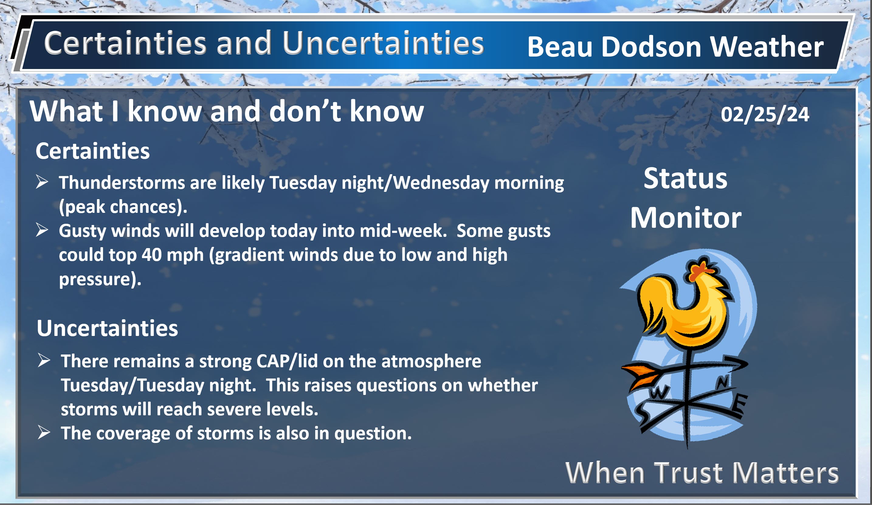
1. Is lightning in the forecast? YES. Monday afternoon into Wednesday. Peak chances for lightning will be Tuesday night into early Wednesday morning. I will monitor Wednesday afternoon over our southeast counties (east of LBL in western Kentucky into northwest Tennessee).
2. Are severe thunderstorms in the forecast? MONITOR. There is a conditional threat of severe thunderstorms Tuesday evening into Wednesday. I will need to monitor the timing of the cold front. Stay tuned and monitor updated information over the coming days. I will send app messages to you over the coming days.
Overall, the threat appears limited.
There will be a strong CAP/lid on the atmosphere Tuesday and Tuesday night. This could hamper thunderstorm development early on. The CAP should weaken Tuesday night ahead of the cold front.
What is a CAP? Here is a video.
.
.
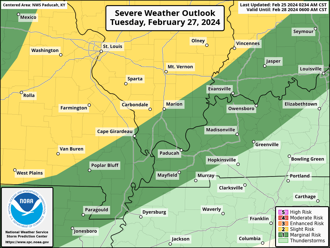
The Storm Prediction Center has already outlined our region for severe storms.
As always, don’t get too caught up in the colors. The atmosphere doesn’t always obey our colors. The yellow zone appears to have a slightly higher chance of severe weather than the dark green. But, a severe storm is a sever storm. Whether it is in the yellow or dark green doesn’t matter. The light green is where sub-severe storms are possible.
Tuesday
Double click the images to enlarge them.
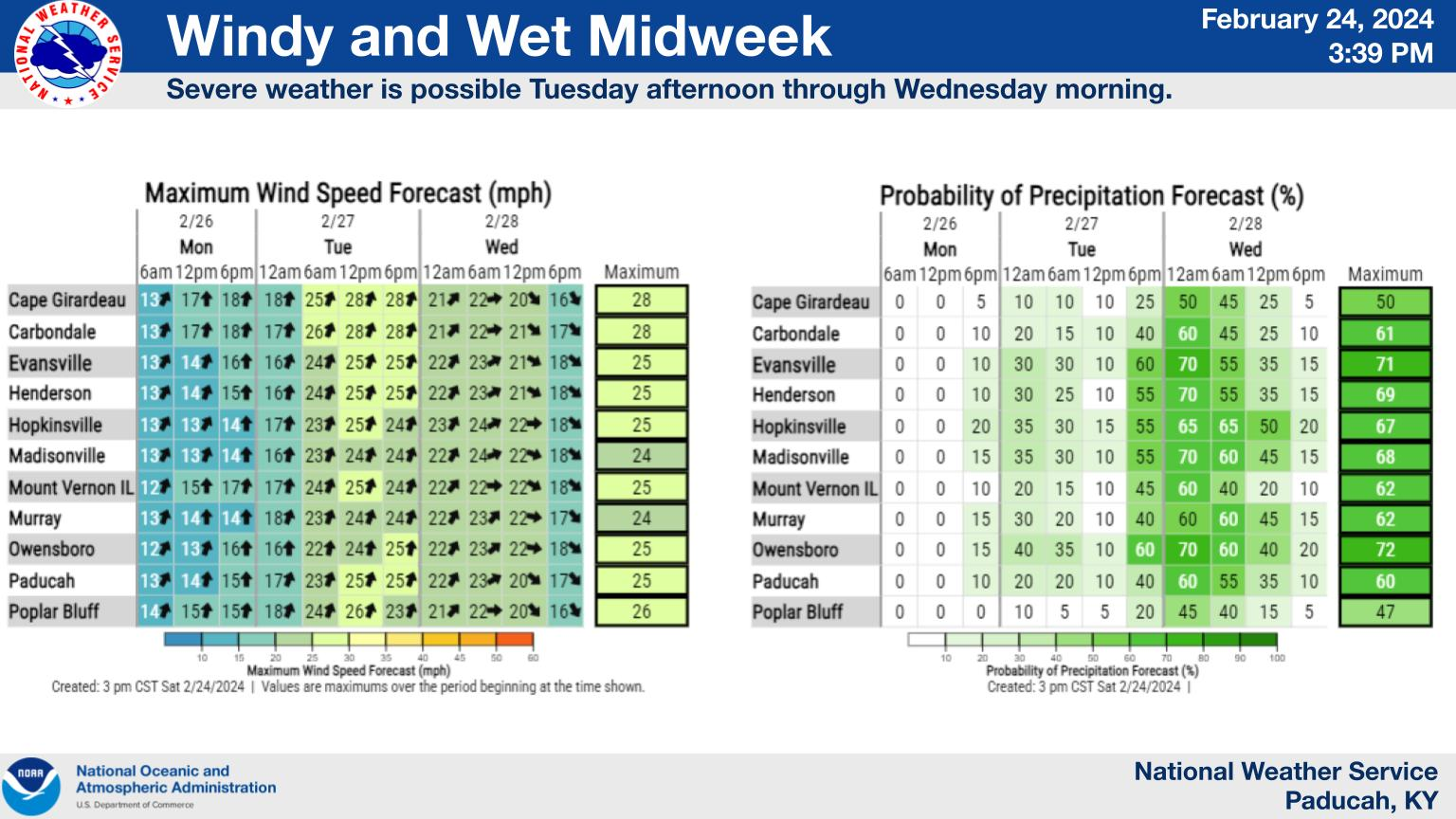
Wind forecast and timing of precipitation chances.
3. Is flash flooding in the forecast? UNLIKELY.
4. Will non-thunderstorm winds top 40 mph? POSSIBLE. Gusty winds will develop Sunday into Thursday. Wind gusts above 40 mph can’t be ruled out. This will be because of the tight barometric pressure gradient developing between high and low pressure.
Highest gradient winds are likely to be Tuesday into Wednesday. Centered on Tuesday afternoon and night.
4. Will the heat index exceed 100 degrees? NO.
5. Will the wind chill dip below 10 degrees? NO.
6. Is measurable snow and/or sleet in the forecast? NO.
7. Is freezing rain/ice in the forecast? NO.
Freezing rain is rain that falls and instantly freezes on objects such as trees and power lines Freezing fog possible, as well.
.

Fire weather risk level.
Sunday into Sunday night: 5. Medium risk.
Monday: 4. Low risk.
Monday night: 5. Medium risk.
Fire Weather Discussion
Dry weather is expected today through daytime hours Monday as winds become breezy out of the SSW. RHs below 30% remain possible this afternoon in the Ozarks. With warm and moist advection early week, temperatures surge well into the 70s Monday and Tuesday with dew points rising to the upper 50s to near 60 Tuesday. Wind gusts of 40+ mph are likely for much of the forecast area beginning late Tuesday ahead of a strong cold front. Showers and thunderstorms are forecast along and ahead of the front with Tuesday night into Wednesday morning the most likely timing of the cold front. Much colder temperatures are expected for Thursday with a quick warm up for Friday into next weekend.
A Haines Index of 6 means a high potential for an existing fire to become large or exhibit erratic fire behavior, 5 means medium potential, 4 means low potential, and anything less than 4 means very low potential.
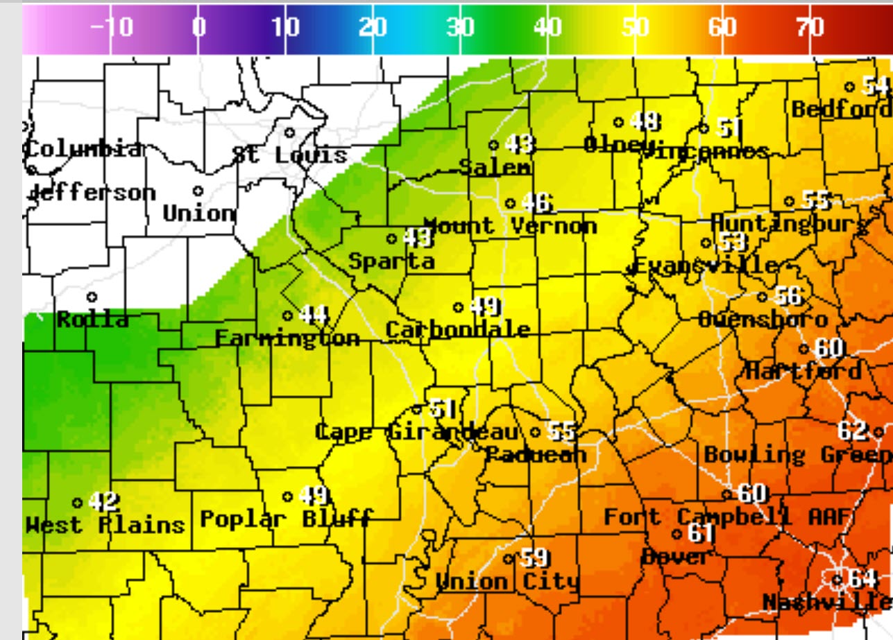
Seven-day forecast for southeast Missouri, southern Illinois, western Kentucky, and western Tennessee.
This is a BLEND for the region. Scroll down to see the region by region forecast.
.

THE FORECAST IS GOING TO VARY FROM LOCATION TO LOCATION. Scroll down to see your local forecast details.
48-hour forecast Graphics


.
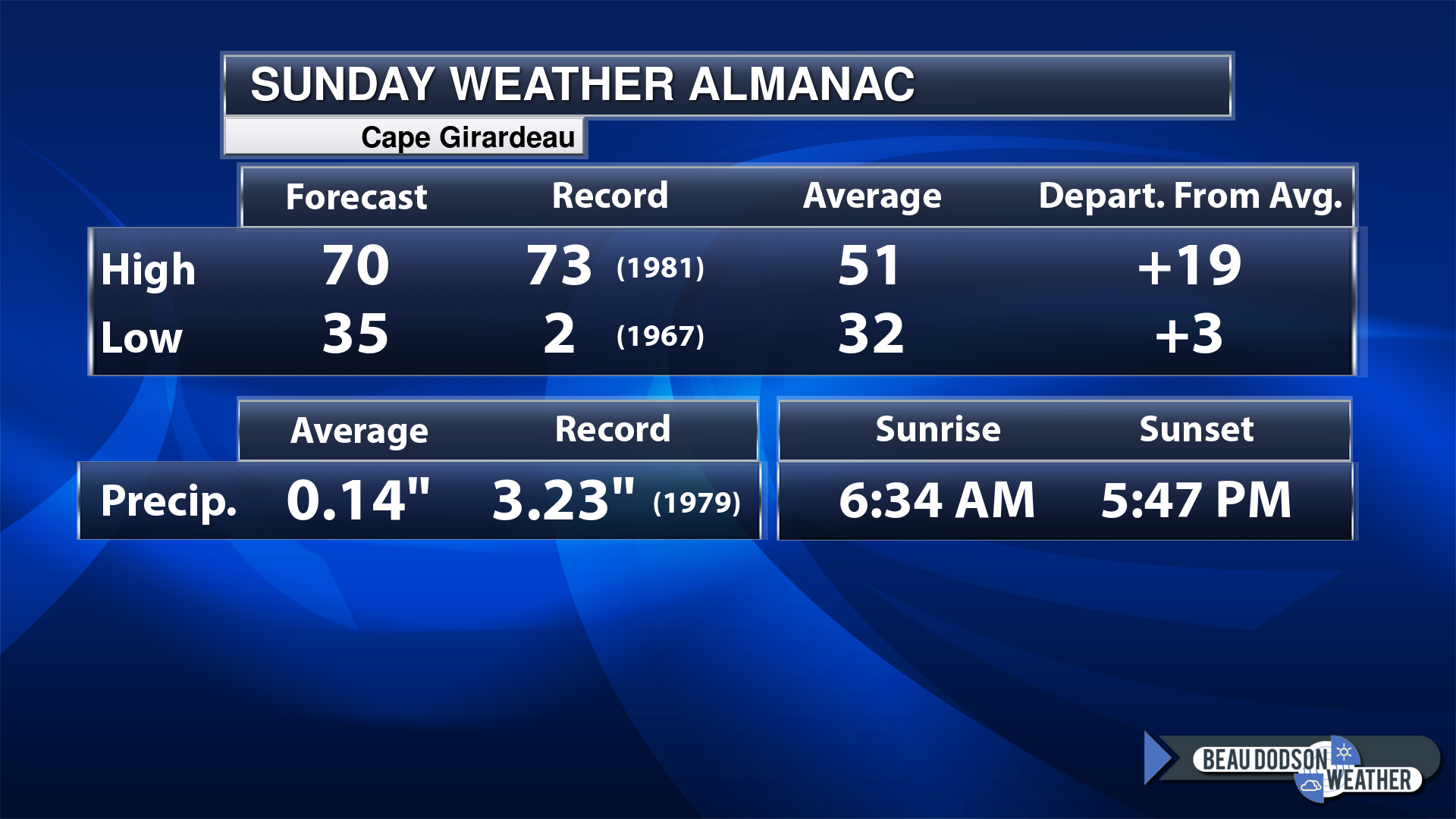
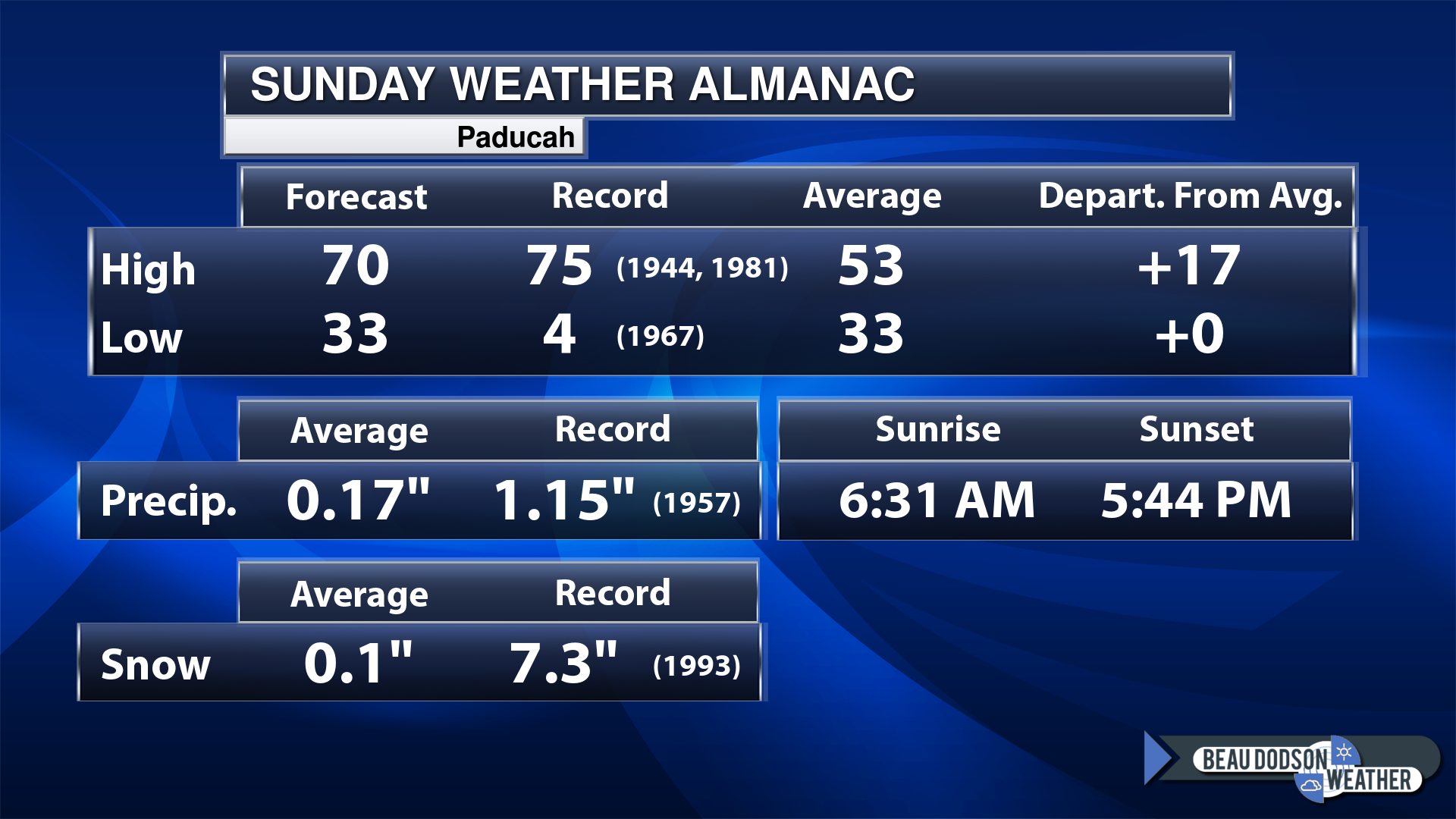
Today’s Local Almanacs (for a few select cities). Your location will be comparable.
Note, the low is this morning’s low and not tomorrows.
The forecast temperature shows you today’s expected high and this morning’s low.
The graphic shows you the record high and record low for today. It shows you what year that occurred, as well.
It then shows you what today’s average temperature is.
It shows you the departures (how may degrees above or below average temperatures will be ).
It shows you the average precipitation for today. Average comes from thirty years of rain totals.
It also shows you the record rainfall for the date and what year that occurred.
The sunrise and sunset are also shown.


![]()
.
.
Sunday Forecast: Mostly sunny. A brief period of clouds moving west to east this morning. Mild. Breezy, at times.
What is the chance of precipitation?
Far northern southeast Missouri ~ 0%
Southeast Missouri ~ 0%
The Missouri Bootheel ~ 0%
I-64 Corridor of southern Illinois ~ 0%
Southern Illinois ~ 0%
Extreme southern Illinois (southern seven counties) ~ 0%
Far western Kentucky (Purchase area) ~ 0%
The Pennyrile area of western KY ~ 0%
Northwest Kentucky (near Indiana border) ~ 0%
Northwest Tennessee ~ 0%
Coverage of precipitation:
Timing of the precipitation:
Far northern southeast Missouri ~ 72° to 74°
Southeast Missouri ~ 70° to 74°
The Missouri Bootheel ~ 70° to 74°
I-64 Corridor of southern Illinois ~ 66° to 70°
Southern Illinois ~ 68° to 70°
Extreme southern Illinois (southern seven counties) ~ 68° to 70°
Far western Kentucky ~ 68° to 70°
The Pennyrile area of western KY ~ 68° to 70°
Northwest Kentucky (near Indiana border) ~ 68° to 70°
Northwest Tennessee ~ 68° to 70°
Winds will be from this direction: South southwest 15 to 25 mph. Gusty.
Wind chill or heat index (feels like) temperature forecast: 65° to 70°
What impacts are anticipated from the weather?
Should I cancel my outdoor plans? No
UV Index: 4. Moderate.
Sunrise: 6:32 AM
Sunset: 5:45 PM .
.
Sunday Night Forecast: Partly cloudy.
What is the chance of precipitation?
Far northern southeast Missouri ~ 0%
Southeast Missouri ~ 0%
The Missouri Bootheel ~ 0%
I-64 Corridor of southern Illinois ~ 0%
Southern Illinois ~ 0%
Extreme southern Illinois (southern seven counties) ~ 0%
Far western Kentucky (Purchase area) ~ 0%
The Pennyrile area of western KY ~ 0%
Northwest Kentucky (near Indiana border) ~ 0%
Northwest Tennessee ~ 0%
Coverage of precipitation:
Timing of the precipitation:
Temperature range:
Far northern southeast Missouri ~ 42° to 44°
Southeast Missouri ~ 44° to 48°
The Missouri Bootheel ~ 50° to 52°
I-64 Corridor of southern Illinois ~ 42° to 44°
Southern Illinois ~ 42° to 44°
Extreme southern Illinois (southern seven counties) ~ 46° to 48°
Far western Kentucky ~ 46° to 50°
The Pennyrile area of western KY ~ 48° to 50°
Northwest Kentucky (near Indiana border) ~ 44° to 46°
Northwest Tennessee ~ 50° to 52°
Winds will be from this direction: South southwest 10 to 20 mph. Gusty.
Wind chill or heat index (feels like) temperature forecast: 38° to 44°
What impacts are anticipated from the weather?
Should I cancel my outdoor plans? No
Moonrise: 7:00 PM
Moonset: 7:15 AM
The phase of the moon: Waning Gibbous
.
Monday Forecast: Mostly sunny. Very warm. Breezy.
What is the chance of precipitation?
Far northern southeast Missouri ~ 0%
Southeast Missouri ~ 0%
The Missouri Bootheel ~ 0%
I-64 Corridor of southern Illinois ~ 0%
Southern Illinois ~ 0%
Extreme southern Illinois (southern seven counties) ~ 0%
Far western Kentucky (Purchase area) ~ 0%
The Pennyrile area of western KY ~ 0%
Northwest Kentucky (near Indiana border) ~ 0%
Northwest Tennessee ~ 0%
Coverage of precipitation:
Timing of the precipitation:
Far northern southeast Missouri ~ 74° to 78°
Southeast Missouri ~ 73° to 76°
The Missouri Bootheel ~ 73° to 76°
I-64 Corridor of southern Illinois ~ 70° to 74°
Southern Illinois ~ 72° to 74°
Extreme southern Illinois (southern seven counties) ~ 72° to 74°
Far western Kentucky ~ 72° to 74°
The Pennyrile area of western KY ~ 72° to 74°
Northwest Kentucky (near Indiana border) ~ 72° to 74°
Northwest Tennessee ~ 72° to 74°
Winds will be from this direction: South southwest 15 to 35 mph. Gusty.
Wind chill or heat index (feels like) temperature forecast: 70° to 78°
What impacts are anticipated from the weather?
Should I cancel my outdoor plans? No
UV Index: 4. Moderate.
Sunrise: 6:31 AM
Sunset: 5:46 PM .
.
Monday Night Forecast: Partly cloudy. Windy. A slight chance of showers and thunderstorms.
What is the chance of precipitation?
Far northern southeast Missouri ~ 10%
Southeast Missouri ~ 10%
The Missouri Bootheel ~ 10%
I-64 Corridor of southern Illinois ~ 20%
Southern Illinois ~ 20%
Extreme southern Illinois (southern seven counties) ~ 20%
Far western Kentucky (Purchase area) ~ 30%
The Pennyrile area of western KY ~ 30%
Northwest Kentucky (near Indiana border) ~ 30%
Northwest Tennessee ~ 20%
Here are where the rain chances are more likely.
Coverage of precipitation: Isolated
Timing of the precipitation: Any given point of time.
Temperature range:
Far northern southeast Missouri ~ 56° to 60°
Southeast Missouri ~ 56° to 60°
The Missouri Bootheel ~ 56° to 60°
I-64 Corridor of southern Illinois ~ 56° to 60°
Southern Illinois ~ 56° to 60°
Extreme southern Illinois (southern seven counties) ~ 56° to 60°
Far western Kentucky ~ 56° to 60°
The Pennyrile area of western KY ~ 58° to 60°
Northwest Kentucky (near Indiana border) ~ 56° to 60°
Northwest Tennessee ~ 58° to 60°
Winds will be from this direction: South southwest 15 to 30 mph. Gusty.
Wind chill or heat index (feels like) temperature forecast: 56° to 60°
What impacts are anticipated from the weather? Isolated wet roadways. Lightning.
Should I cancel my outdoor plans? No
Moonrise: 7:57 PM
Moonset: 7:37 AM
The phase of the moon: Waning Gibbous
.
Tuesday Forecast: A mix of sun and clouds. Very warm. Windy. A chance of showers and thunderstorms. There will be a strong CAP/lid on the atmosphere. This could keep thunderstorms from forming until the cold front moves in Tuesday night.
What is the chance of precipitation?
Far northern southeast Missouri ~ 40%
Southeast Missouri ~ 20%
The Missouri Bootheel ~ 10%
I-64 Corridor of southern Illinois ~ 30%
Southern Illinois ~ 20%
Extreme southern Illinois (southern seven counties) ~ 20%
Far western Kentucky (Purchase area) ~ 20%
The Pennyrile area of western KY ~ 20%
Northwest Kentucky (near Indiana border) ~ 20%
Northwest Tennessee ~ 20%
Coverage of precipitation: Isolated
Timing of the precipitation: Mostly after 3 PM.
Far northern southeast Missouri ~ 76° to 82°
Southeast Missouri ~ 76° to 78°
The Missouri Bootheel ~ 76° to 78°
I-64 Corridor of southern Illinois ~ 74° to 78°
Southern Illinois ~ 74° to 78°
Extreme southern Illinois (southern seven counties) ~ 74° to 78°
Far western Kentucky ~ 74° to 78°
The Pennyrile area of western KY ~ 74° to 78°
Northwest Kentucky (near Indiana border) ~ 74° to 78°
Northwest Tennessee ~ 74° to 78°
Winds will be from this direction: South southwest 15 to 35 mph. Gusty.
Wind chill or heat index (feels like) temperature forecast: 70° to 78°
What impacts are anticipated from the weather? Wet roadways. Lightning. Monitor the risk of intense thunderstorms late in the day.
Should I cancel my outdoor plans? Monitor updates.
UV Index: 2. Low.
Sunrise: 6:29 AM
Sunset: 5:47 PM .
.
Tuesday Night Forecast: Mostly cloudy. Thunderstorms are likely. A few storms could be intense. Monitor updates.
What is the chance of precipitation?
Far northern southeast Missouri ~ 80%
Southeast Missouri ~ 80%
The Missouri Bootheel ~ 70%
I-64 Corridor of southern Illinois ~ 70%
Southern Illinois ~ 70%
Extreme southern Illinois (southern seven counties) ~ 70%
Far western Kentucky (Purchase area) ~ 70%
The Pennyrile area of western KY ~ 60%
Northwest Kentucky (near Indiana border) ~ 70%
Northwest Tennessee ~ 70%
Coverage of precipitation: Numerous
Timing of the precipitation: Any given point of time.
Temperature range:
A wide range of temperatures ahead and behind the incoming cold front.
Far northern southeast Missouri ~ 42° to 45°
Southeast Missouri ~ 44° to 46°
The Missouri Bootheel ~ 48° to 50°
I-64 Corridor of southern Illinois ~ 46° to 48°
Southern Illinois ~ 46° to 50°
Extreme southern Illinois (southern seven counties) ~ 52° to 55°
Far western Kentucky ~ 53° to 56°
The Pennyrile area of western KY ~ 58° to 62°
Northwest Kentucky (near Indiana border) ~ 55° to 60°
Northwest Tennessee ~ 58° to 52°
Winds will be from this direction: South southwest 15 to 30 mph. Gusty.
Wind chill or heat index (feels like) temperature forecast: 38° to 58°
What impacts are anticipated from the weather? Wet roadways. Lightning. Severe storms possible.
Should I cancel my outdoor plans? Monitor updates.
Moonrise: 8:54 PM
Moonset: 7:57 AM
The phase of the moon: Waning Gibbous
.
Wednesday Forecast: Mostly cloudy. A chance of morning showers and thunderstorms. Rain may end as rain/snow. Falling temperatures.
What is the chance of precipitation?
Far northern southeast Missouri ~ 30%
Southeast Missouri ~ 30%
The Missouri Bootheel ~ 30%
I-64 Corridor of southern Illinois ~ 30%
Southern Illinois ~ 40%
Extreme southern Illinois (southern seven counties) ~ 40%
Far western Kentucky (Purchase area) ~ 60%
The Pennyrile area of western KY ~ 60%
Northwest Kentucky (near Indiana border) ~ 60%
Northwest Tennessee ~60%
Coverage of precipitation: Scattered to perhaps numerous early in the day.
Timing of the precipitation: Mostly before noon.
Far northern southeast Missouri ~ 45° to 50°
Southeast Missouri ~ 46° to 50°
The Missouri Bootheel ~ 50° to 52°
I-64 Corridor of southern Illinois ~ 50° to 52°
Southern Illinois ~ 52° to 54°
Extreme southern Illinois (southern seven counties) ~ 53° to 56°
Far western Kentucky ~ 54° to 58°
The Pennyrile area of western KY ~ 58° to 62°
Northwest Kentucky (near Indiana border) ~ 52° to 55°
Northwest Tennessee ~ 56° to 60°
Winds will be from this direction: Southwest becoming west northwest at 15 to 35 mph. Gusty.
Wind chill or heat index (feels like) temperature forecast: 40° to 58°
What impacts are anticipated from the weather? Wet roadways. Lightning.
Should I cancel my outdoor plans? Monitor updates and radars.
UV Index: 3. Moderate.
Sunrise: 6:28 AM
Sunset: 5:48 PM .
.
Wednesday Night Forecast: Decreasing clouds. A slight chance of evening showers over our eastern counties.
What is the chance of precipitation?
Far northern southeast Missouri ~ 10%
Southeast Missouri ~ 10%
The Missouri Bootheel ~ 10%
I-64 Corridor of southern Illinois ~ 10%
Southern Illinois ~ 10%
Extreme southern Illinois (southern seven counties) ~ 20%
Far western Kentucky (Purchase area) ~ 20%
The Pennyrile area of western KY ~ 30%
Northwest Kentucky (near Indiana border) ~ 20%
Northwest Tennessee ~ 20%
Coverage of precipitation: Isolated
Timing of the precipitation: Before 9 PM
Temperature range:
Far northern southeast Missouri ~ 20° to 24°
Southeast Missouri ~ 22° to 24°
The Missouri Bootheel ~ 22° to 25°
I-64 Corridor of southern Illinois ~ 20° to 22°
Southern Illinois ~ 22° to 24°
Extreme southern Illinois (southern seven counties) ~ 22° to 24°
Far western Kentucky ~ 22° to 25°
The Pennyrile area of western KY ~ 23° to 26°
Northwest Kentucky (near Indiana border) ~ 22° to 25°
Northwest Tennessee ~ 24° to 26°
Winds will be from this direction: Northwest 10 to 20 mph. Gusty.
Wind chill or heat index (feels like) temperature forecast: 15° to 25°
What impacts are anticipated from the weather?
Should I cancel my outdoor plans?
Moonrise: 9:53 PM
Moonset: 8:19 AM
The phase of the moon: Waning Gibbous
.
Click here if you would like to return to the top of the page.

-
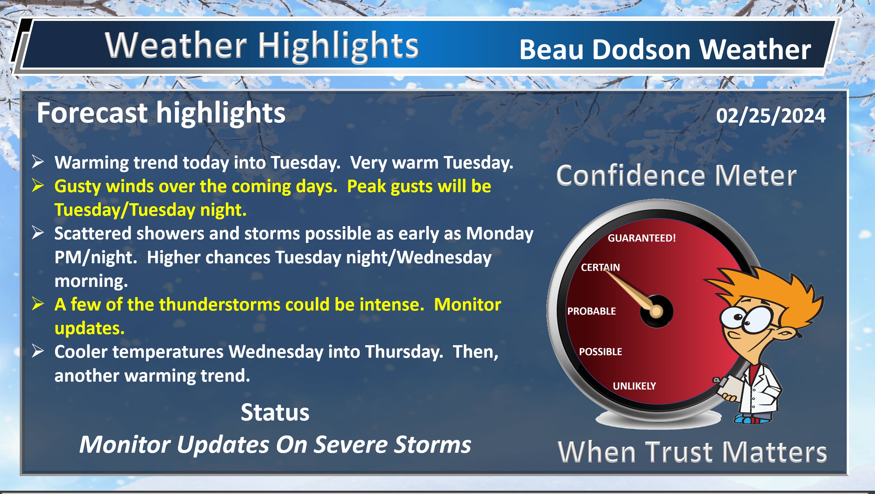
- Warming trend today into Tuesday.
- Very warm tomorrow and Tuesday.
- Gusty winds developing today into Wednesday. Occasional gusts above 30 mph likely (perhaps even 40 mph Tuesday/Tuesday night).
- A few showers and thunderstorms as early as tomorrow/tomorrow night (mainly eastern counties).
- Increasing storm chances late Tuesday into Wednesday morning.
- Some of the storms could be intense. There is a limited threat of severe weather. Monitor updates.
Weather advice:
Do you have any suggestions or comments? Email me at beaudodson@usawx.com
Make sure you have three to five ways of receiving your severe weather information.
We needmore storm spotters! Consider signing up for an in-person class or a zoom class.

Register at this link CLICK HERE
Beau’s Forecast Discussion
No significant weather concerns through Monday morning.
A thin band of clouds will move west to east across the region this morning and afternoon. It should be in and out fairly quickly. So, we should have quite a bit of sunshine today, as well.
Temperatures will rebound today and that begins our warming trend that will last into Tuesday night/Wednesday morning.
Gusty winds will develop today and linger into Wednesday. Peak winds will be Tuesday and Tuesday night. This is when winds will range from 25 to 40 mph. Gusty.
These winds will be gradient winds. Gradient winds are caused by tight pressure gradients.
See these squiggly black lines? Those are equal lines of pressure. As they tighter, winds increase.
There will be enough moisture for isolated to scattered showers and thunderstorms Monday evening into Monday night. That will mainly be over our eastern counties. See the forecast at the top of the page for more information. Lightning will be the only concern. No severe weather Monday or Monday night.
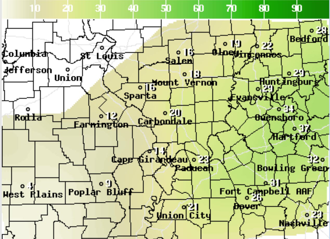
All eyes then turn to Tuesday’s weather.
Just wow. Look at this temperature forecast map for Tuesday. Winter? Where have you gone!
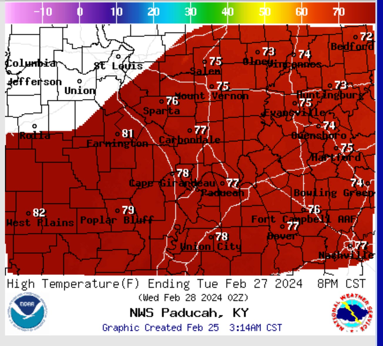
Record breaking temperatures are possible Tuesday.
The next subject will be thunderstorms.
There will be a very strong cap on the atmosphere.
This is the CAP. Where the red line darts to the right. The CAP keeps storms from forming.
In order for storms to form, you need to erode that CAP. Then, the line is straight (without a bump in it). That means air can freely flow upward. That allows storms to form.
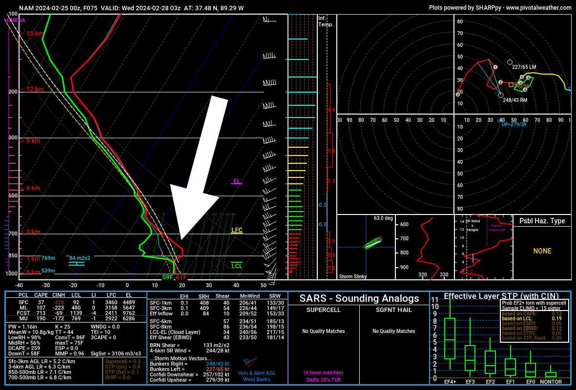
The very strong CAP will initially keep storms from forming Tuesday. I believe the CAP will hold until evening or Tuesday night.
Thus, the chance of storms forming Tuesday morning or afternoon will be limited. Isolated.
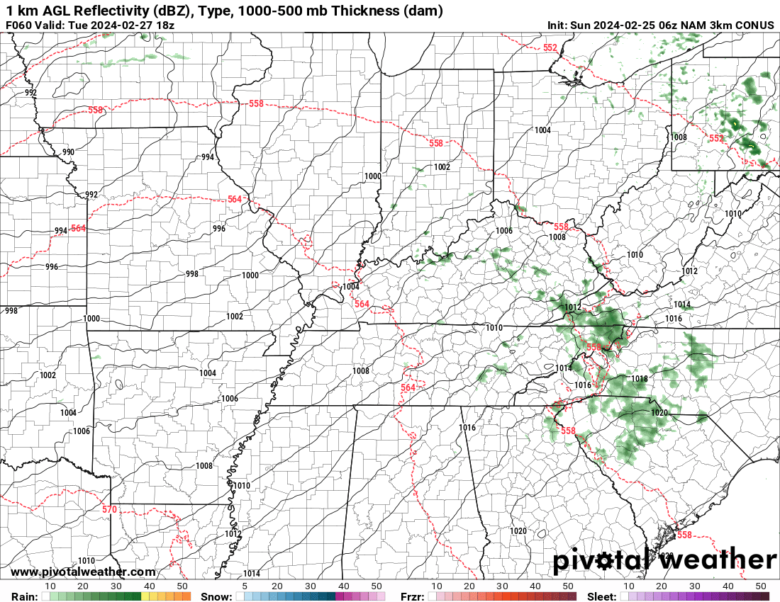
A strong cold front will sweep into the region Tuesday night and Wednesday. There remain questions on the timing.
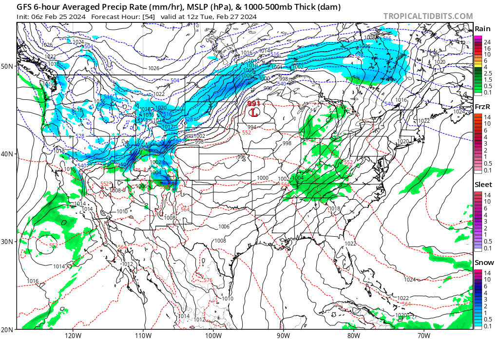
Check out the cold front on the GFS model. The warm air ahead of the front. The cold air sweeps in behind the front.
The GFS is somewhat slower than the EC model. The NAM model is slower than the GFS model. Thus, I need to monitor trends concerning the timing of frontal passage.
Showers and thunderstorms will form along and ahead of the cold front. A squall line is possible.
What is a squall line? A line of thunderstorms. A few of the storms could be intense. There is a limited severe threat.
The strong CAP raises questions, however, about the extent of the severe weather threat.
For now, the SPC has us outlined for severe storms Tuesday night/Wednesday morning.
There could still be adjustments in the severe weather outlook. The event is still three days away. Monitor updates.
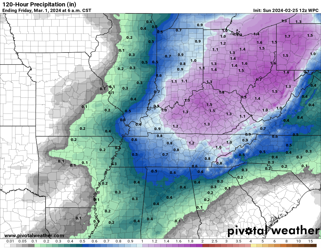
Anticipated rainfall totals
Cooler air arrives Wednesday into Thursday, then another warming trend. What cold air does filter into the region will be short lived.
Our above average temperatures are likely to continue over the coming weeks.
I don’t believe we are finished with below freezing temperatures. This raises concerns about fruit trees and other vegetation that blossoms in the warm air.
![]()
.
Click here if you would like to return to the top of the page.
This outlook covers southeast Missouri, southern Illinois, western Kentucky, and far northwest Tennessee.

.
Today’s Storm Prediction Center’s Severe Weather Outlook
Light green is where thunderstorms may occur but should be below severe levels.
Dark green is a level one risk. Yellow is a level two risk. Orange is a level three (enhanced) risk. Red is a level four (moderate) risk. Pink is a level five (high) risk.
One is the lowest risk. Five is the highest risk.
A severe storm is one that produces 58 mph wind or higher, quarter size hail, and/or a tornado.
Explanation of tables. Click here.

.
Tornado Probability Outlook

.
Large Hail Probability Outlook

.
High wind Probability Outlook

.
Tomorrow’s severe weather outlook.

.
Day Three Severe Weather Outlook

.

.
The images below are from NOAA’s Weather Prediction Center.
24-hour precipitation outlook..
 .
.
.
48-hour precipitation outlook.
. .
.
![]()
_______________________________________
.

Click here if you would like to return to the top of the page.
Again, as a reminder, these are models. They are never 100% accurate. Take the general idea from them.
What should I take from these?
- The general idea and not specifics. Models usually do well with the generalities.
- The time-stamp is located in the upper left corner.
.
What am I looking at?
You are looking at computer model data. Meteorologists use many different models to forecast the weather.
Occasionally, these maps are in Zulu time. 12z=7 AM. 18z=1 PM. 00z=7 PM. 06z=1 AM
Green represents light rain. Dark green represents moderate rain. Yellow and orange represent heavier rain.
.
This animation is the HRRR Model.
Occasionally, these maps are in Zulu time. 12z=6 AM. 18z=12 PM. 00z=6 PM. 06z=12 AM
Double click images to enlarge them. Blue is snow. Pink is a wintry mix. Green is rain.
.
This animation is the NAM Model.
Occasionally, these maps are in Zulu time. 12z=6 AM. 18z=12 PM. 00z=6 PM. 06z=12 AM
Double click images to enlarge them.
.
This animation is the GFS Model.
Green is rain. Yellow and orange are heavier rain. Pink is a wintry mix. Blue is snow. Dark blue is heavier snow.
Occasionally, these maps are in Zulu time. 12z=6 AM. 18z=12 PM. 00z=6 PM. 06z=12 AM
Double click images to enlarge them.
.
This animation is the EC Model.
Green is rain. Yellow and orange are heavier rain. Pink is a wintry mix. Blue is snow. Dark blue is heavier snow.
Occasionally, these maps are in Zulu time. 12z=6 AM. 18z=12 PM. 00z=6 PM. 06z=12 AM
Double click images to enlarge them.
..![]()

.
Click here if you would like to return to the top of the page.
.Average high temperatures for this time of the year are around 51 degrees.
Average low temperatures for this time of the year are around 31 degrees.
Average precipitation during this time period ranges from 0.50″ to 1.00″
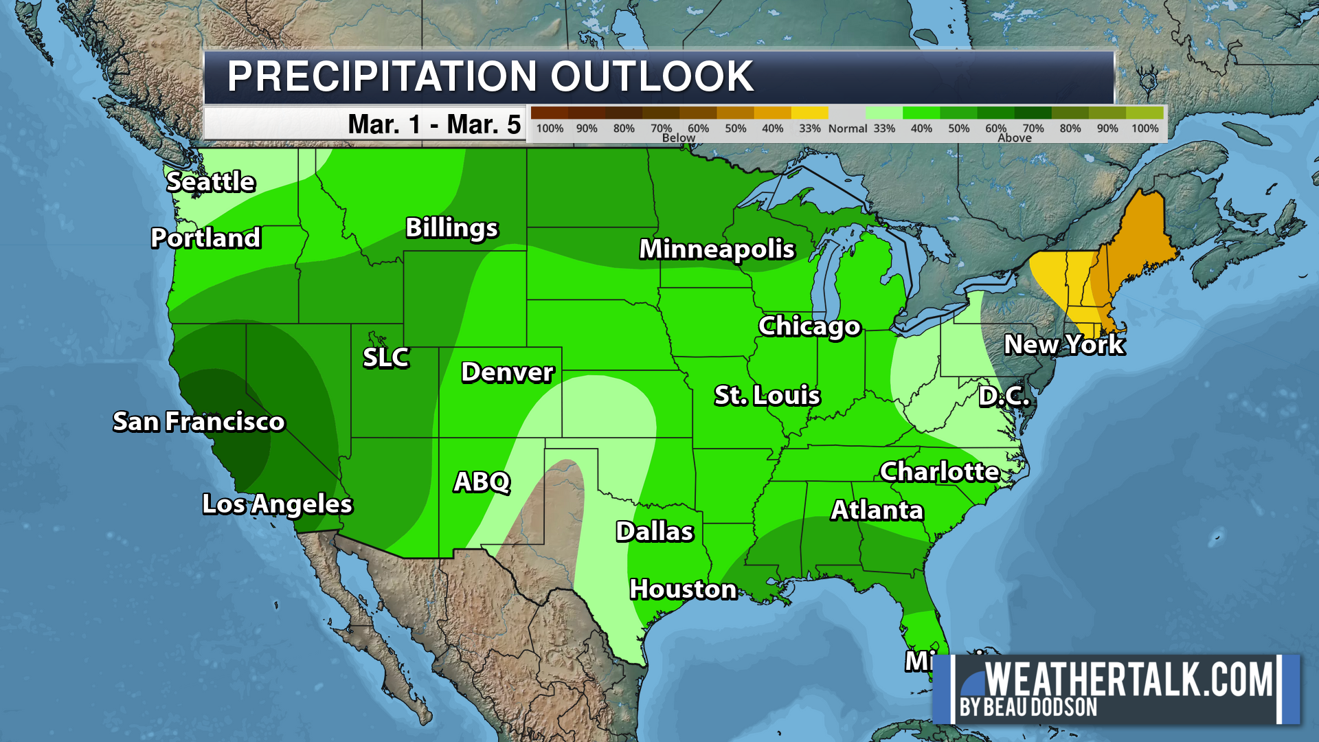
Six to Ten Day Outlook.
Blue is below average. Red is above average. The no color zone represents equal chances.
Average highs for this time of the year are in the lower 60s. Average lows for this time of the year are in the lower 40s.
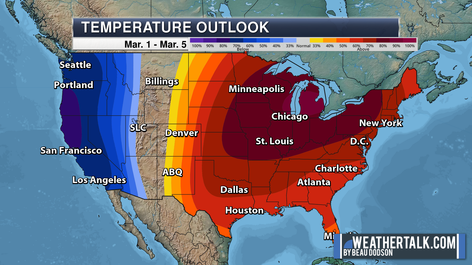
Green is above average precipitation. Yellow and brown favors below average precipitation. Average precipitation for this time of the year is around one inch per week.
.

Average low temperatures for this time of the year are around 32 degrees.
Average precipitation during this time period ranges from 0.50″ to 1.00″
.
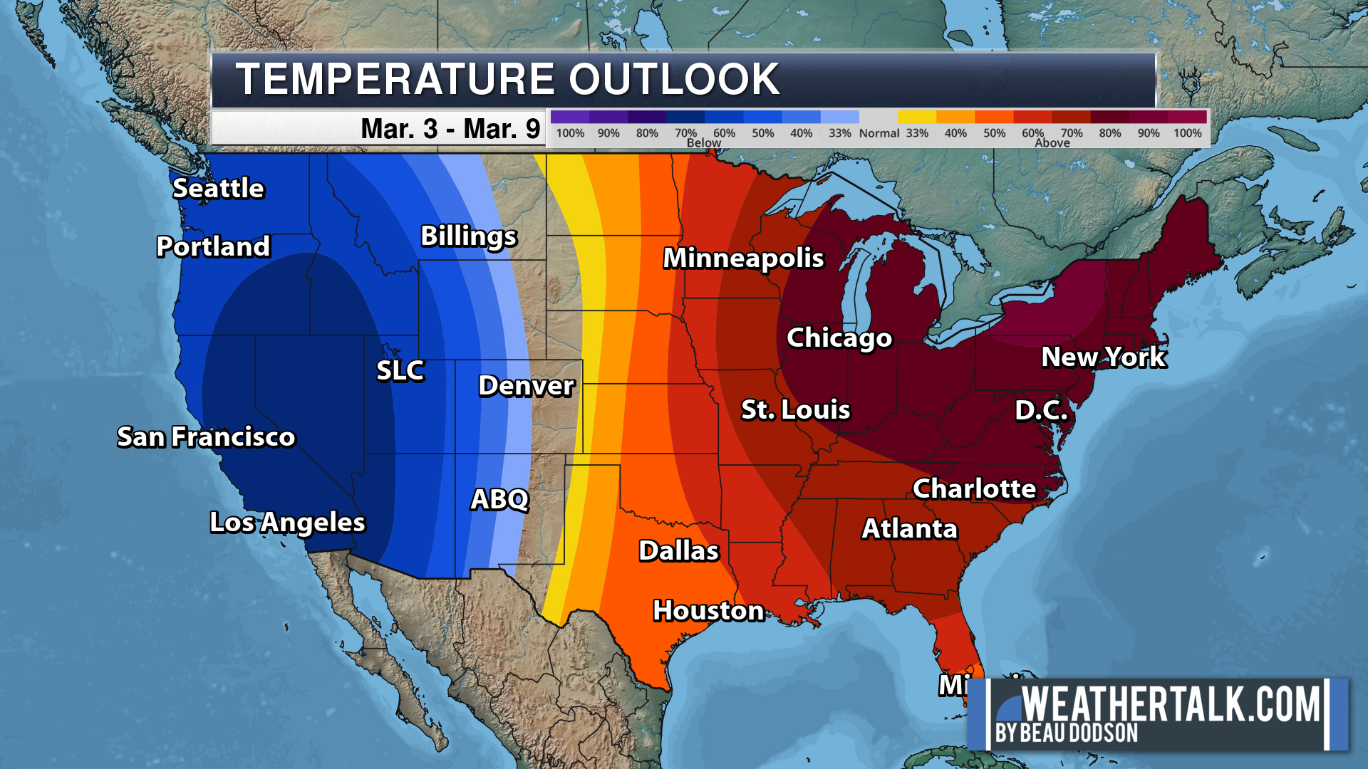
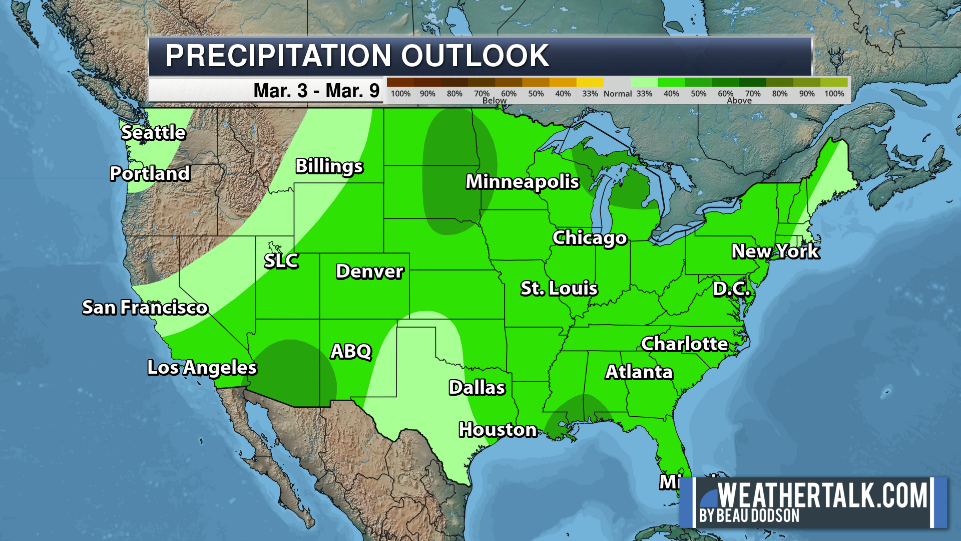
Eight to Fourteen Day Outlook.
Blue is below average. Red is above average. The no color zone represents equal chances.
Green is above average precipitation. Yellow and brown favors below average precipitation. Average precipitation for this time of the year is around one inch per week.
.
![]()
The app is for subscribers. Subscribe at www.weathertalk.com/welcome then go to your app store and search for WeatherTalk
Subscribers, PLEASE USE THE APP. ATT and Verizon are not reliable during severe weather. They are delaying text messages.
The app is under WeatherTalk in the app store.

Apple users click here

Android users click here
.

Radars and Lightning Data
Interactive-city-view radars. Clickable watches and warnings.
https://wtalk.co/B3XHASFZ
If the radar is not updating then try another one. If a radar does not appear to be refreshing then hit Ctrl F5. You may also try restarting your browser.
Backup radar site in case the above one is not working.
https://weathertalk.com/morani
Regional Radar
https://imagery.weathertalk.com/prx/RadarLoop.mp4
** NEW ** Zoom radar with chaser tracking abilities!
ZoomRadar
Lightning Data (zoom in and out of your local area)
https://wtalk.co/WJ3SN5UZ
Not working? Email me at beaudodson@usawx.com
National map of weather watches and warnings. Click here.
Storm Prediction Center. Click here.
Weather Prediction Center. Click here.
.

Live lightning data: Click here.
Real time lightning data (another one) https://map.blitzortung.org/#5.02/37.95/-86.99
Our new Zoom radar with storm chases
.
.

Interactive GOES R satellite. Track clouds. Click here.
GOES 16 slider tool. Click here.
College of DuPage satellites. Click here
.

Here are the latest local river stage forecast numbers Click Here.
Here are the latest lake stage forecast numbers for Kentucky Lake and Lake Barkley Click Here.
.
.
Find Beau on Facebook! Click the banner.


 .
.