4:30 AM.
Saturday, February 24, 2024
Severe Weather Outlook
Here is the SPC technical discussion.
https://www.spc.noaa.gov/products/exper/day4-8/
Good day, everyone.
Make sure you have three to five ways of receiving severe weather information.
One of those ways should be the Beau Dodson Weather App/Weather Talk app. You can subscribe to that at www.weathertalk.com
Remember, I send out rapid fire tornado alerts. With each radar scan, you will receive an update on where the circulation is and where it is moving.
A weather radio is another great source, local television meteorologists is another, weather apps, radio, WEA on your cell phone (google it), and outdoor sirens.
Do not rely on just one or two of those. Everything can fail. During the 2009 ice storm, the 2011 southern tornado outbreak. and the December 2021 tornado outbreak almost everything failed (including NOAA weather radios).
I will be at a weather conference today. I will try and check questions from time time.
First, , this event is still four days away. Just like snowstorms, the forecast will likely need adjustments.
Don’t walk away with one forecast and assume it won’t change.
Severe weather, like snowstorms, can be quite fickle. Meaning, small changes in the storm track or moisture could lead to significant adjustments in the forecast.
I will know a lot more Sunday afternoon and night. The system will move ashore by then. The model guidance will sample it better (once onshore).
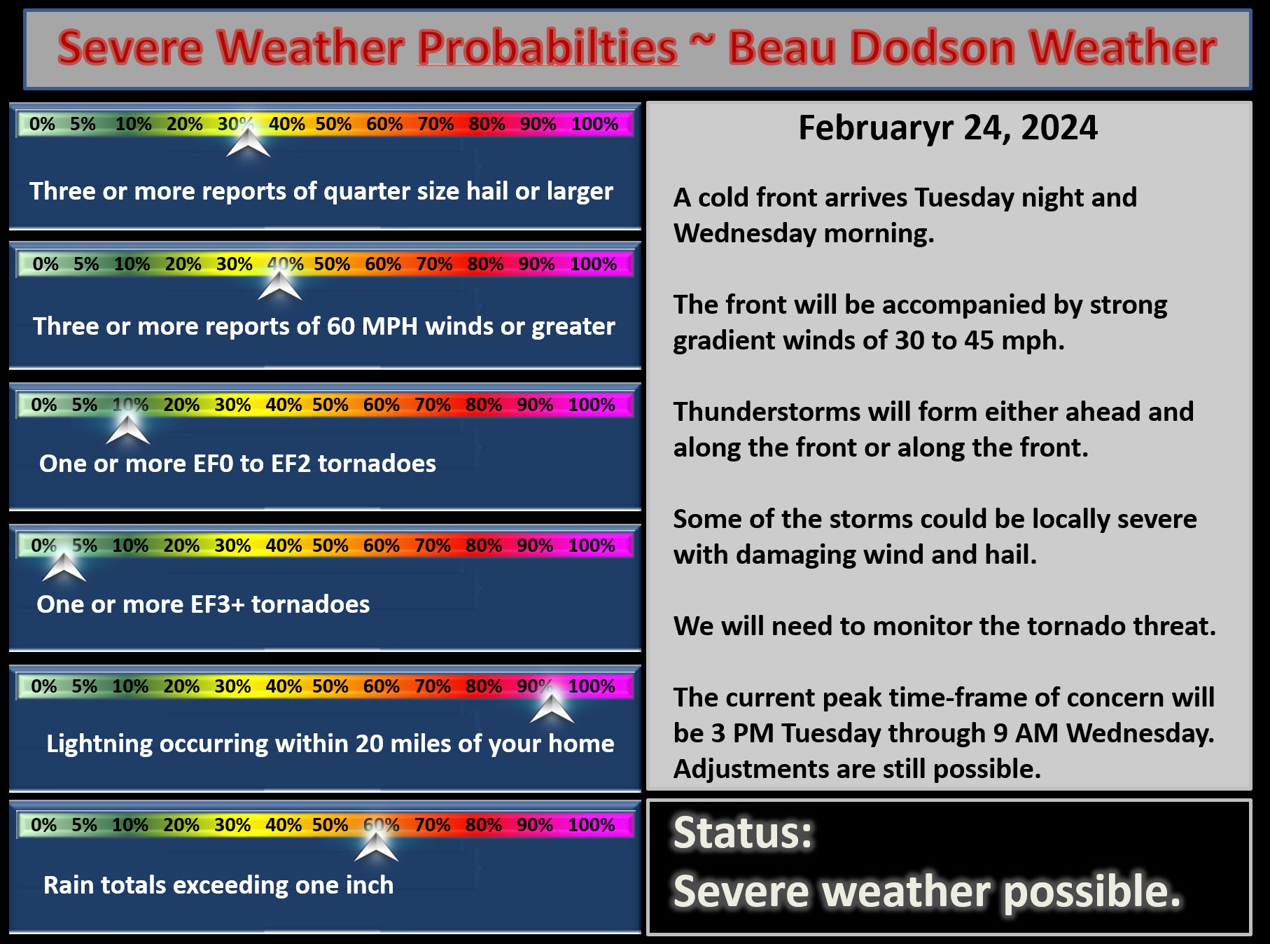
The primary concern will be a strong cold front Tuesday night into early Wednesday morning.
Thunderstorms will form along the front. Some of the storms will likely be severe.
At this time, it appears this will likely not be supercells. Although, that could change.
The concern, for now at least, is a squall line. A line of thunderstorms moving through the region Tuesday night.
This line would have intense storms embedded within it. Any bowing line segments could cause damaging wind and even brief QLCS tornadoes.
QLCS tornadoes are usually in the EF0 to EF2 range. They track a few miles and then lift. They are difficult to issue warnings on, because of how fast they develop and dissipate.
The bigger concern, however, will be pockets of 60 mph wind gusts. Damaging wind. A few hail reports, as well.
The event may end up passing through our region late Tuesday night. If that happens, then we would be at an instability minimum.
Peak instability is usually during the afternoon and evening. Then, overnight instability usually wanes.
This raises question to the extent of the severe potential.
On the other hand, some data brings the front through late Tuesday afternoon into Tuesday evening/mid-evening. If that were to happen, then the severe risk would be higher.
As you can see above, there remain forecast questions. That is not uncommon when an event is still days away.
Again, this event is still four days away. Adjustments in the placement of severe weather are still possible.
The Storm Prediction Center has outlined our region for severe thunderstorms Tuesday PM into early Wednesday AM.
If the front moves fast enough, then we won’t have additional concerns Wednesday afternoon. That will need to be monitored, as well.