We have some great sponsors for the Weather Talk Blog. Please let our sponsors know that you appreciate their support for the Weather Talk Blog.
Milner and Orr Funeral Home and Cremation Services located in Paducah, Kentucky and three other western Kentucky towns – at Milner and Orr they believe in families helping families. You can find Milner and Orr on Facebook, as well.
![]()
.

For all of your families eye care needs. Visit their web-site here. Or, you can also visit their Facebook page.
.

Best at Enabling Body Shop Profitability since 1996. Located In Paducah Kentucky and Evansville Indiana; serving all customers in between. They provide Customer Service, along with all the tools necessary for body shops to remain educated and competitive. Click the logo above for their main web-site. You can find McClintock Preferred Finishes on Facebook, as well
.

Duck/goose decoys? Game calls? Optics? We have you covered! Click the logo above or visit Final Flight on Facebook, as well.
.
I have launched the new weather texting service! I could use your help. Be sure and sign up and fully support all of the weather data you see each day.
This is a monthly subscription service. Supporting this helps support everything else. The cost is $3 a month for one phone, $5 a month for three phones, and $10 a month for seven phones.
For more information visit BeauDodsonWeather.com
Or directly sign up at Weathertalk.com


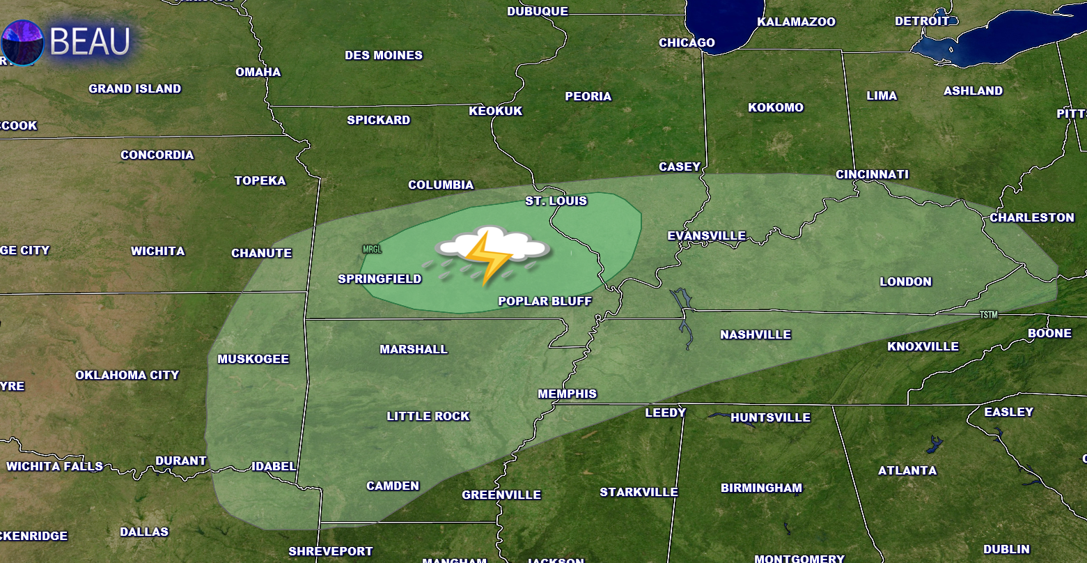
This forecast update covers far southern Illinois, far southeast Missouri, and far western Kentucky. See the coverage map on the right side of the blog.
Remember that weather evolves. Check back frequently for updates, especially during active weather.

Winter Weather Radars
WEATHER RADAR PAGE – Click here —
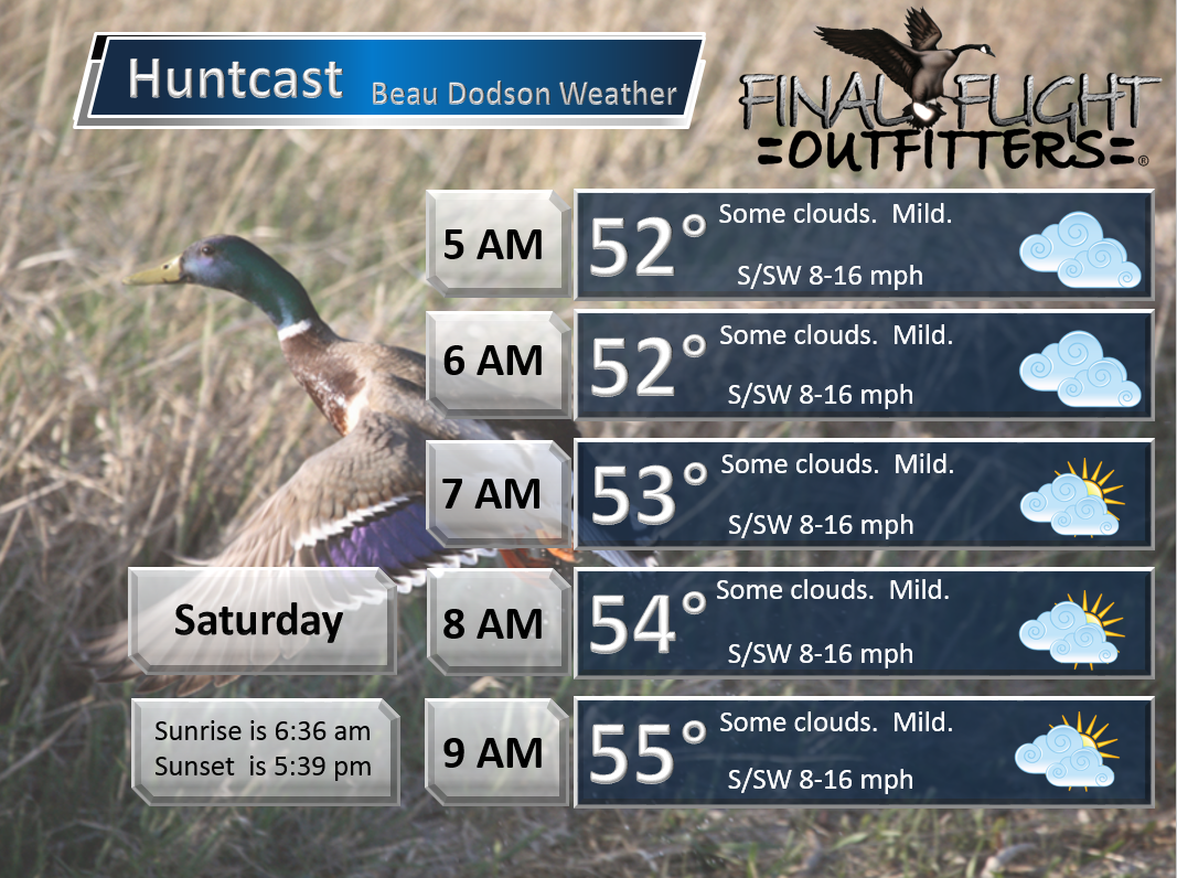
Friday Night – Partly to mostly cloudy. Mild. Breezy at times.
Temperatures: Lows in the 48 to 54 degree range.
Winds: South winds at 8-16 mph early. Then 5-10 mph late.
What is the chance for precipitation? 0%
Coverage of precipitation? None
My confidence in this part of the forecast verifying is High
Should I be concerned about snow or ice? No
Should I cancel my outdoor plans? No
Is severe weather expected? No
What impact is expected? None
Saturday – Quite a few clouds. Very warm for February. Breezy. Perhaps an afternoon shower or thunderstorm.
Temperatures: Highs in the 68-76 degree range.
Winds: South and southwest winds at 8-16 mph.
What is the chance for precipitation? 20%
Coverage of precipitation? Perhaps some spotty showers in the afternoon. Better chances Saturday night/Sunday.
My confidence in this part of the forecast verifying is High
Should I be concerned about snow or ice? No
Should I cancel my outdoor plans? No
Is severe weather expected? No, but lightning is possible late in the day and perhaps a couple of reports of hail.
What impact is expected? None
Saturday Night – Cloudy. A chance for showers and perhaps thunderstorms. Lightning possible. Small chance for hail.
Temperatures: Lows in the lower to middle 50s.
Winds: South winds at 8-16 mph.
What is the chance for precipitation? 50%-60%
Coverage of precipitation? Scattered to widespread
My confidence in this part of the forecast verifying is High
Should I be concerned about snow or ice? No
Should I cancel my outdoor plans? No
Is severe weather expected? No, but lightning is possible. A few reports of hail can’t be ruled out.
What impact is expected? Wet roadways possible. Maybe some lightning.
Sunday – Cloudy. Some showers possible. Maybe a rumble of thunder.
Temperatures: Highs in the 62-66 degree range.
Winds: South and southwest winds at 8-16 mph. Winds may shift out of the northwest during the afternoon and evening.
What is the chance for precipitation? 60%
Coverage of precipitation? Scattered to perhaps widespread.
My confidence in this part of the forecast verifying is High
Should I be concerned about snow or ice? No
Should I cancel my outdoor plans? No
Is severe weather expected? No
What impact is expected? Lightning possible. Wet roadways likely.
Sunday Night – Cloudy. Cooler Maybe a remaining evening shower.
Temperatures: Lows in the upper 30s to lower 40s
Winds: North winds at 10 mph.
What is the chance for precipitation? 10%- 20%
Coverage of precipitation? Maybe an evening shower.
My confidence in this part of the forecast verifying is High
Should I be concerned about snow or ice? No
Should I cancel my outdoor plans? No
Is severe weather expected? No
What impact is expected? Wet roadways possible.
Monday – Partly cloudy. Not as mild.
Temperatures: Highs in the 46 to 52 degree range.
Winds: North and northeast at 5-10 mph.
What is the chance for precipitation? 0%
Coverage of precipitation? None
My confidence in this part of the forecast verifying is High
Should I be concerned about snow or ice? No
Should I cancel my outdoor plans? No
Is severe weather expected? No
What impact is expected? None

Don’t forget to check out the Southern Illinois Weather Observatory web-site for weather maps, tower cams, scanner feeds, radars, and much more! Click here

An explanation of what is happening in the atmosphere over the coming days…
Highlights
1. Saturday will deliver mild temperatures
2. Rain showers possible Saturday night/Sunday. Thunderstorm not out of the question
3. Colder next week.
4. I continue to track the Tuesday and Wednesday winter weather event.
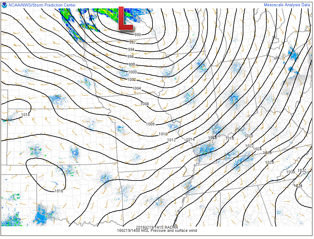
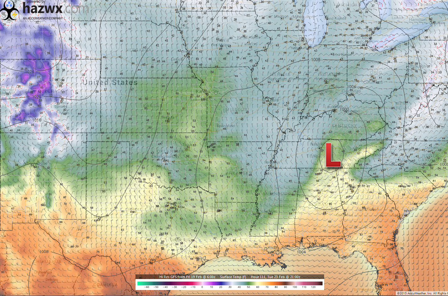
Windy windy. Friday delivered some wind gusts over 50 mph to the area. Tight pressure gradient was responsible for the high winds.
Here is the Storm Prediction’s isobar map from Friday morning. The low was in Minnesota. Look how tight the isobars are. The isobars are equal lines of pressure. That would be the black lines you see on this map. The red L is the area of low pressure.
It has been awhile since I have seen the isobars so packed together.
Warm warm warm! WOOHOO. I am just as excited as everyone else. I love mild weather in the winter. At least occasionally. Winter is not over, but this is a nice break.
Did you know that temperatures rose into the 80s and 90s over Kansas and Oklahoma on Thursday? Amazing warmth. We were not that warm, but 60s were common on Friday.
Clouds will continue to be on the increase tonight into Saturday. Our next weather maker will deliver some shower chances by Saturday night into Sunday. Thunderstorms are also possible. Lightning being the main concern. And, I can’t rule out a report or two of hail.
Here is the thunderstorm risk zone from the Storm Prediction Center. Areas to the east of this could also experience lightning. Not expecting severe storms.
There is a small chance of a scattered shower on Saturday afternoon. However, this does not look to be a widespread problem.
Rainfall totals should be light with this event. A few days ago I was thinking a bit more. But, with time, it appears 0.10″-0.30″ might be the general rule. Emphasis on lighter vs heavier.
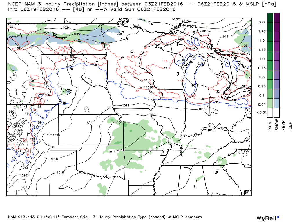
The best chance for showers will be Saturday night and Sunday morning.
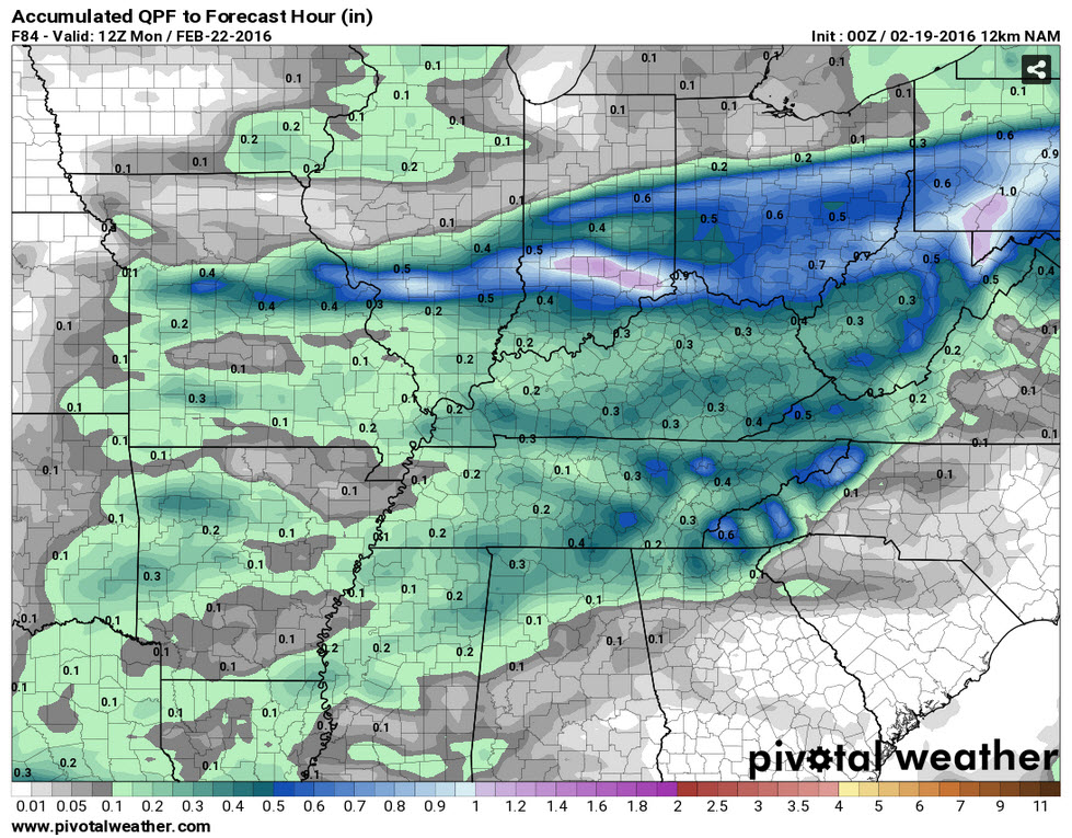
Here is the NAM guidance for Saturday night around 11 pm or 12 am Sunday morning. The green represents a few showers.
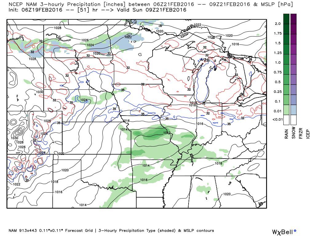
Moving ahead to Sunday morning around 3 am. Some thunderstorms possible. Weak area of low pressure situated over central Missouri. Closed isobars on the map.
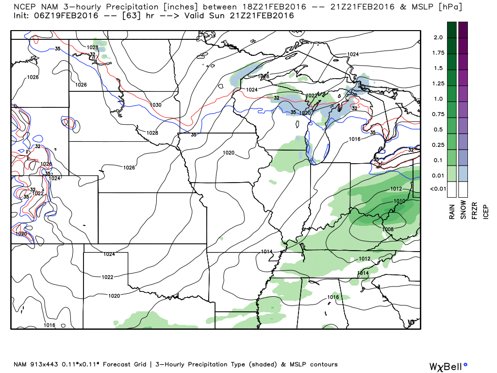
Moving ahead to Sunday afternoon. Rain should be on the way out by late Sunday morning into the afternoon hours. Again, lightning will be possible.
Here is a zoomed in version of the NAM model. You can see it is painting 0.10″-0.30″ of precipitation over the region. This is the total rainfall map through Sunday afternoon.
Let’s move ahead
I continue to monitor a system for next Tuesday night-Thursday (centered on Wednesday). The track has shifted westward with the latest guidance. But, I don’t really trust guidance this far out. The data has shown everything from a low moving across the southern U.S. and off the coast to the low tracking into Kentucky. Wild swings like that tell me not to trust guidance.
Ensembles, which I do have a little more faith in, indicate this system could track into the Tennessee Valley. That would also be supported by teleconnections. If true then we might have some precipitation in our general region on Tuesday night or Wednesday.
Let’s just keep watching it.
Here is the GFS showing the low over the Tennessee Valley next Wednesday.
Too soon to make a call on where it will track. And, this chart is even too warm for snow in our region.

No snow or ice expected through Monday

Saturday – No snow or ice anticipated.
Sunday – No snow or ice anticipated.
Monday – No snow or ice anticipated.
Tuesday – Currently no snow or ice anticipated. But, monitor updates.
Wednesday – Currently no snow or ice anticipated. But, monitor updates.

No major changes in this forecast update.

No major concerns for Friday night into Saturday.
Lightning possible Saturday night and Sunday morning. Small chance late in the afternoon, as well. Especially over northern parts of southeast Missouri and southwest Illinois. Better chances Saturday night.
Small chance for hail.


The wild card will be rainfall totals this coming weekend. Shower chances ramp up on Saturday night into Sunday. A few guidance packages bring a shower into the region on Saturday. But, I believe the better chances will hold off until Saturday night/Sunday. Rainfall totals over our southern counties might be heavier than northern counties.

How much precipitation should we expect over the next few days?
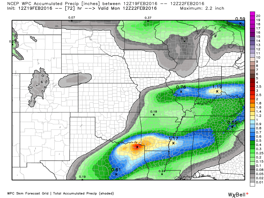
This is the precipitation for Saturday into Sunday night. Not a lot. 0.10″-0.30″. The heavier axis has shifted south quite a bit since the last update.

Can we expect severe thunderstorms over the next 24 to 48 hours? Remember that a severe thunderstorm is defined as a thunderstorm that produces 58 mph winds or higher, quarter size hail or larger, and/or a tornado.
The thunderstorm threat level will be a ZERO on Saturday
The thunderstorm threat level will be a ONE on Saturday night. Lightning and maybe a few reports of hail.
The thunderstorm threat level will be a ONE on Sunday
The thunderstorm threat level will be a ZERO on Monday

Here is the official 6-10 day and 8-14 day temperature and precipitation outlook. Check the date stamp at the top of each image (so you understand the time frame).
The forecast maps below are issued by the Weather Prediction Center (NOAA).


The latest 8-14 day temperature and precipitation outlook. Note the dates are at the top of the image. These maps DO NOT tell you how high or low temperatures or precipitation will be. They simply give you the probability as to whether temperatures or precipitation will be above or below normal.


Here are the current river stage forecasts. You can click your state and then the dot for your location. It will bring up the full forecast and hydrograph.
Click Here For River Stage Forecasts…

Who do you trust for your weather information and who holds them accountable?
I have studied weather in our region since the late 1970’s. I have 37 years of experience in observing our regions weather patterns. My degree is in Broadcast Meteorology from Mississippi State University and an Associate of Science (AS). I am currently working on my Bachelor’s Degree in Geoscience.
My resume includes:
Member of the American Meteorological Society.
NOAA Weather-Ready Nation Ambassador.
Meteorologist for McCracken County Emergency Management. I served from 2005 through 2015.
I own and operate the Southern Illinois Weather Observatory.
Recipient of the Mark Trail Award, WPSD Six Who Make A Difference Award, Kentucky Colonel, and the Caesar J. Fiamma” Award from the American Red Cross.
In 2009 I was presented with the Kentucky Office of Highway Safety Award.
Recognized by the Kentucky House of Representatives for my service to the State of Kentucky leading up to several winter storms and severe weather outbreaks.
I am also President of the Shadow Angel Foundation which serves portions of western Kentucky and southern Illinois.
There is a lot of noise on the internet. A lot of weather maps are posted without explanation. Over time you should learn who to trust for your weather information.
My forecast philosophy is simple and straight forward.
- Communicate in simple terms
- To be as accurate as possible within a reasonable time frame before an event
- Interact with you on Twitter, Facebook, and the blog
- Minimize the “hype” that you might see on television or through other weather sources
- Push you towards utilizing wall-to-wall LOCAL TV coverage during severe weather events
I am a recipient of the Mark Trail Award, WPSD Six Who Make A Difference Award, Kentucky Colonel, and the Caesar J. Fiamma” Award from the American Red Cross. In 2009 I was presented with the Kentucky Office of Highway Safety Award. I was recognized by the Kentucky House of Representatives for my service to the State of Kentucky leading up to several winter storms and severe weather outbreaks.
If you click on the image below you can read the Kentucky House of Representatives Resolution.

Many of my graphics are from www.weatherbell.com – a great resource for weather data, model data, and more


You can sign up for my AWARE email by clicking here I typically send out AWARE emails before severe weather, winter storms, or other active weather situations. I do not email watches or warnings. The emails are a basic “heads up” concerning incoming weather conditions.