We have some great sponsors for the Weather Talk Blog. Please let our sponsors know that you appreciate their support for the Weather Talk Blog.
Milner and Orr Funeral Home and Cremation Services located in Paducah, Kentucky and three other western Kentucky towns – at Milner and Orr they believe in families helping families. You can find Milner and Orr on Facebook, as well.
![]()
.

For all of your families eye care needs. Visit their web-site here. Or, you can also visit their Facebook page.
.

Best at Enabling Body Shop Profitability since 1996. Located In Paducah Kentucky and Evansville Indiana; serving all customers in between. They provide Customer Service, along with all the tools necessary for body shops to remain educated and competitive. Click the logo above for their main web-site. You can find McClintock Preferred Finishes on Facebook, as well
.

Duck/goose decoys? Game calls? Optics? We have you covered! Click the logo above or visit Final Flight on Facebook, as well.
.
I have launched the new weather texting service! I could use your help. Be sure and sign up and fully support all of the weather data you see each day.
This is a monthly subscription service. Supporting this helps support everything else. The cost is $3 a month for one phone, $5 a month for three phones, and $10 a month for seven phones.
For more information visit BeauDodsonWeather.com
Or directly sign up at Weathertalk.com


This forecast update covers far southern Illinois, far southeast Missouri, and far western Kentucky. See the coverage map on the right side of the blog.
Remember that weather evolves. Check back frequently for updates, especially during active weather.

Winter Weather Radars
WEATHER RADAR PAGE – Click here —
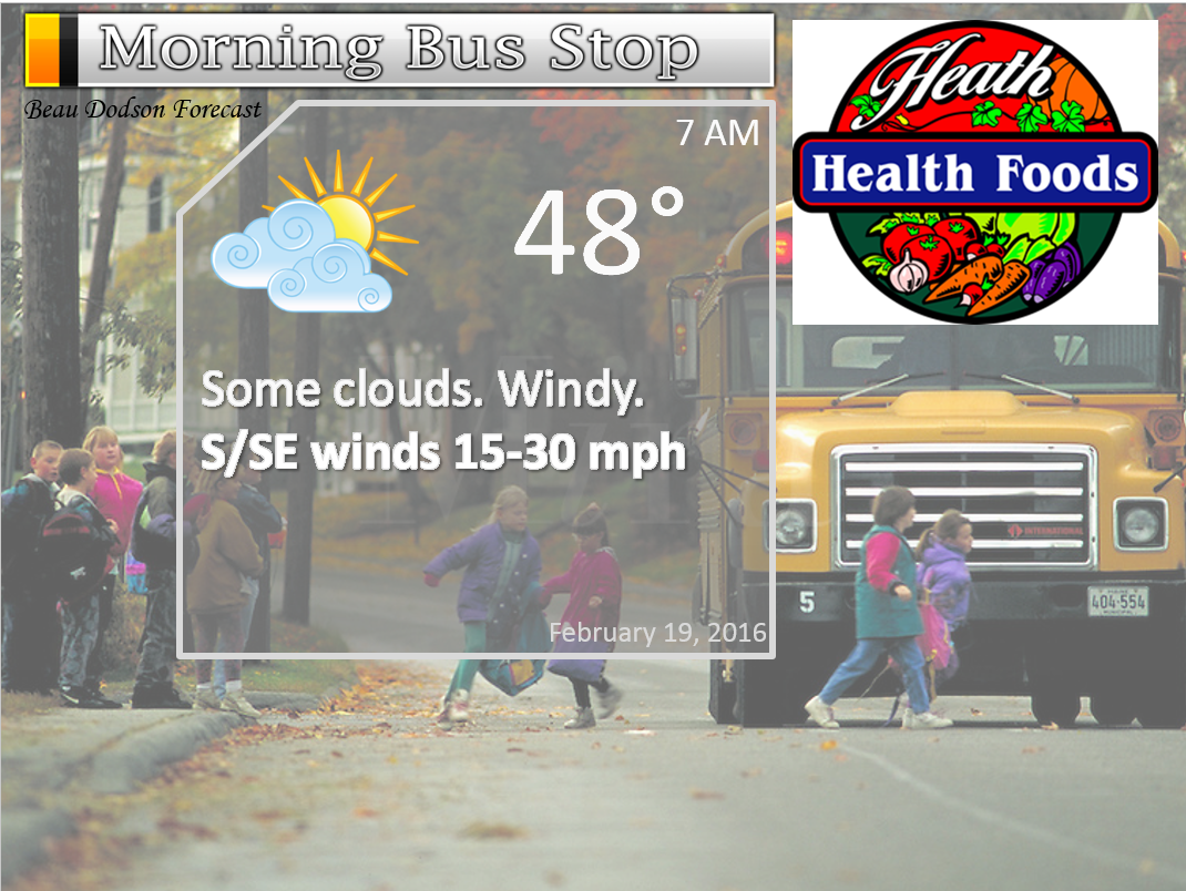
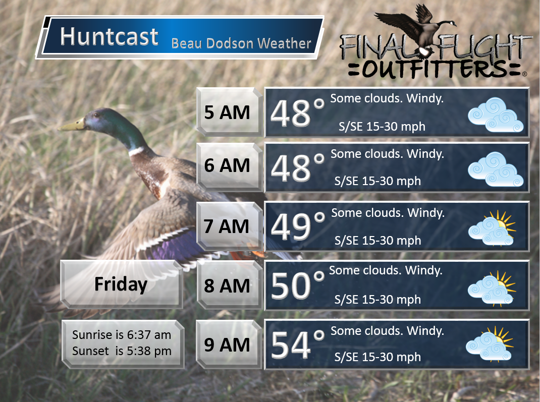
Thursday Night – Partly cloudy. Mild. Breezy at times.
Temperatures: Lows in the upper 40s to around 50 degrees!
Winds: South/southeast winds at 10-20 mph. Gusty, at times.
What is the chance for precipitation? 0%
Coverage of precipitation? None
My confidence in this part of the forecast verifying is High
Should I be concerned about snow or ice? No
Should I cancel my outdoor plans? No
Is severe weather expected? No
What impact is expected? None
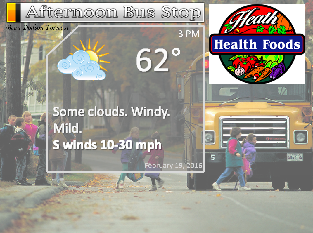
Friday – Windy. Strong/high winds possible. Partly to mostly cloudy. Warm for February.
Temperatures: Highs in the 64-68 degree range.
Winds: South and southwest winds at 10-20 mph and gusts to 30-50 mph possible.
What is the chance for precipitation? 0%
Coverage of precipitation? None
My confidence in this part of the forecast verifying is High
Should I be concerned about snow or ice? No
Should I cancel my outdoor plans? No, but it will be windy
Is severe weather expected? No
What impact is expected? Strong wind potential on Friday.
Friday Night – Partly to mostly cloudy. Mild. Breezy at times.
Temperatures: Lows in the upper 40s to around 50 degrees!
Winds: South winds at 8-16 mph.
What is the chance for precipitation? 0%
Coverage of precipitation? None
My confidence in this part of the forecast verifying is High
Should I be concerned about snow or ice? No
Should I cancel my outdoor plans? No
Is severe weather expected? No
What impact is expected? None
Saturday – Quite a few clouds. Warm for February. Breezy. Perhaps an afternoon shower.
Temperatures: Highs in the 64-68 degree range.
Winds: South and southwest winds at 10-20 mph and gusty.
What is the chance for precipitation? 20%
Coverage of precipitation? Perhaps some spotty showers in the afternoon. Better chances Saturday night/Sunday.
My confidence in this part of the forecast verifying is High
Should I be concerned about snow or ice? No
Should I cancel my outdoor plans? No
Is severe weather expected? No
What impact is expected? None
Saturday Night – Cloudy. A chance for showers.
Temperatures: Lows in the upper 40s to around 50 degrees!
Winds: South winds at 8-16 mph.
What is the chance for precipitation? 40%-50%
Coverage of precipitation? None
My confidence in this part of the forecast verifying is High
Should I be concerned about snow or ice? No
Should I cancel my outdoor plans? No
Is severe weather expected? No
What impact is expected? Wet roadways possible. Maybe some lightning.
Sunday – Cloudy. Some showers possible. Maybe a rumble of thunder.
Temperatures: Highs in the 62-66 degree range.
Winds: South and southwest winds at 10-20 mph and gusty. Winds may shift out of the northwest during the afternoon and evening.
What is the chance for precipitation? 60%
Coverage of precipitation? None
My confidence in this part of the forecast verifying is High
Should I be concerned about snow or ice? No
Should I cancel my outdoor plans? No
Is severe weather expected? No
What impact is expected? Lightning possible. Wet roadways likely.
Sunday Night – Cloudy. Cooler Maybe a remaining evening shower.
Temperatures: Lows in the upper 30s to lower 40s
Winds: North winds at 8-16 mph.
What is the chance for precipitation? 20%
Coverage of precipitation? None
My confidence in this part of the forecast verifying is High
Should I be concerned about snow or ice? No
Should I cancel my outdoor plans? No
Is severe weather expected? No
What impact is expected? Wet roadways possible.
Monday – Partly cloudy. Not as mild.
Temperatures: Highs in the 50-55 degree range.
Winds: North and northeast at 5-10 mph.
What is the chance for precipitation? 0%
Coverage of precipitation? None
My confidence in this part of the forecast verifying is High
Should I be concerned about snow or ice? No
Should I cancel my outdoor plans? No
Is severe weather expected? No
What impact is expected? None

Don’t forget to check out the Southern Illinois Weather Observatory web-site for weather maps, tower cams, scanner feeds, radars, and much more! Click here

An explanation of what is happening in the atmosphere over the coming days…
Highlights
1. Warm and windy
2. Some increase in clouds on Friday into Saturday
3. Rain showers and maybe a thunderstorm this weekend
4. Colder next week
The big weather story is of course the milder temperatures! And, with the milder temperatures will arrive gusty southerly winds. Strong winds likely on Friday. The winds could gust above 45-50 mph.
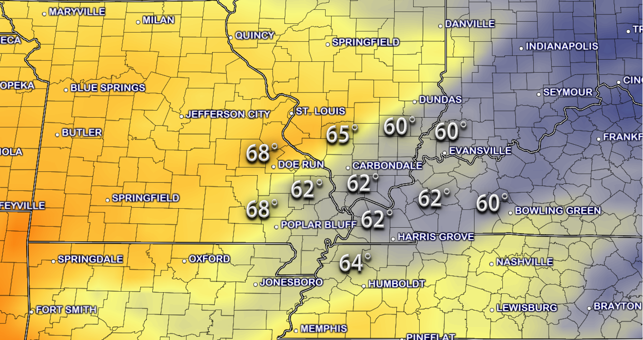
High temperatures on Friday and Saturday should rise into the 60s area wide.
Here are the Friday high temperatures. They will likely be a few degrees higher than this. Lower to middle 60s are a good bet area wide. And, some upper 60s possible.
These are 1 pm temperatures. And, we could rise a few more degrees after that.
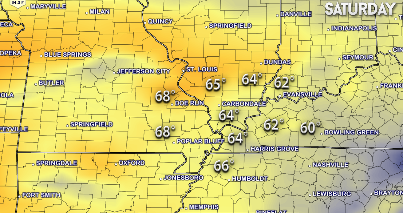
Saturday should be warmer than Friday. Widespread middle to upper 60s. Can parts of southeast Missouri touch 70 on Saturday? It is possible.
These are the 1 to 2 pm temperatures. We could rise a bit higher after that time.
Winds on Friday will be strong and gusty. Expect morning wind gusts above 30 mph. Some open areas could even see wind gusts into the 40s. Either way, a breezy day.
Here is the Friday morning wind gust map.
Strong southerly winds will continue into Friday afternoon and evening. At least we have warm temperatures to go with the windy weather.
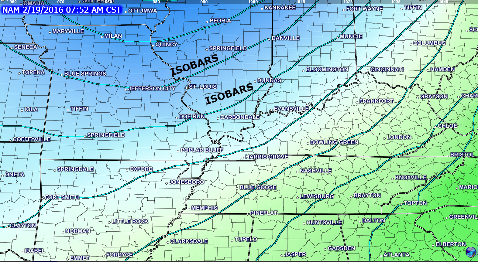
Here is the Friday morning barometric pressure map. The lines are isobars. Equal lines of pressure. The tighter those lines are the windier it is. Lines will be packed fairly tight tomorrow. Thus, windy weather is anticipated.
We will likely see some increase in clouds on both Friday and Saturday.
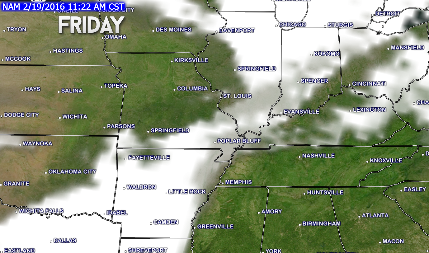
Here is the future-cast satellite view for Friday morning. You can see the areas in white. That represents some increase in clouds over our region. We could see some sun on Friday, as well. But, an increase in clouds is anticipated.
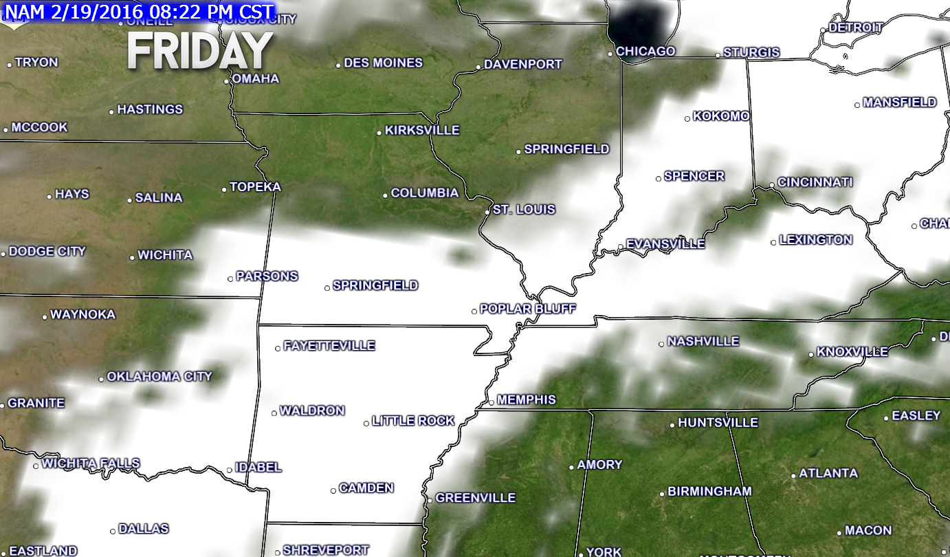
Here is the future-cast satellite view for Friday evening. You can see the white represents some cloud cover.
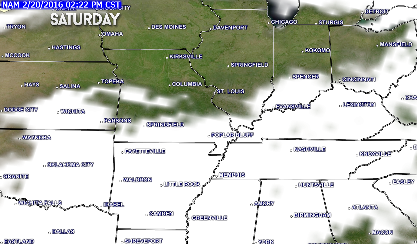
Here is the Saturday map for 2 pm. Some clouds in the region. Increasing clouds in general on Saturday. And, we might end up mostly cloudy. Will have to see how that goes. Sure would be nice to have some more sunshine.
Our next weather maker will be knocking on the door by Saturday night into Sunday. This will spread some rain back into the area. RAIN and not snow! I know some snow fans still would like to see more snow. Some of you have received very little snow, thus far. Others have hit the jackpot. As a matter of fact, Paducah is nearing a top ten snowiest winter. They just need one more inch of snow.
Too warm for snow this weekend. That is for sure. We might even experience some thunderstorms (not severe).
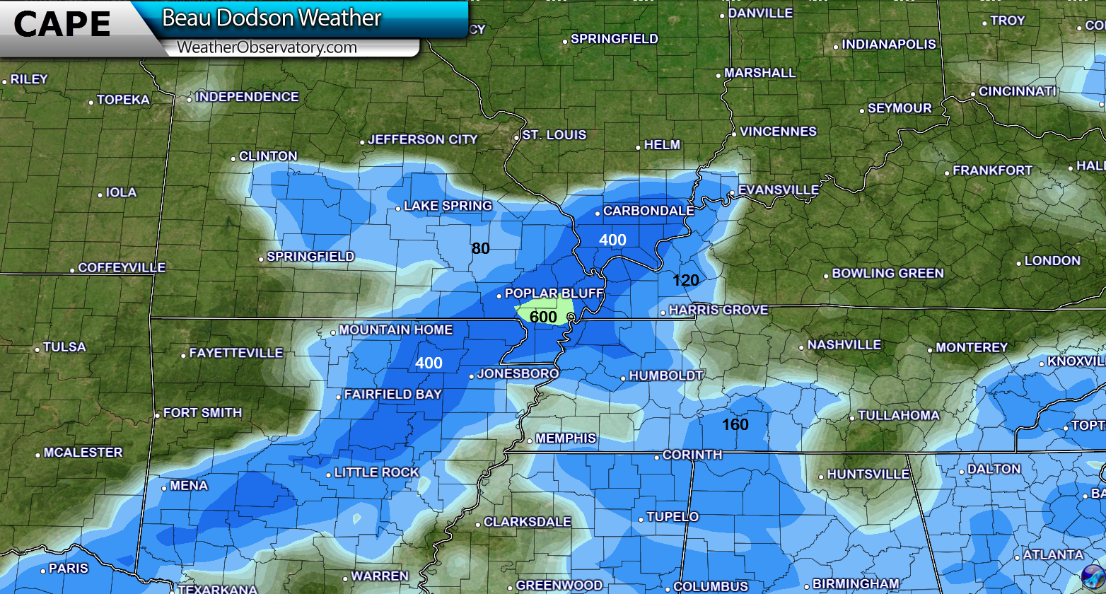
I talk quite a bit about CAPE during the spring and summer months. Occasionally in the fall and winter. CAPE is basically energy available for thunderstorms. We do have some CAPE on Saturday night and especially on Sunday. Not expecting severe storms, but certainly a rumble of thunder will be possible.
Here is the Sunday morning CAPE map. The blue colors represent around 300-600 joules of surface based CAPE.
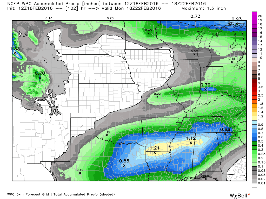
Rain shower chances on Saturday night into Sunday will likely be in the 50%-70% range. Whether a few showers develop on Saturday afternoon will need to be monitored.
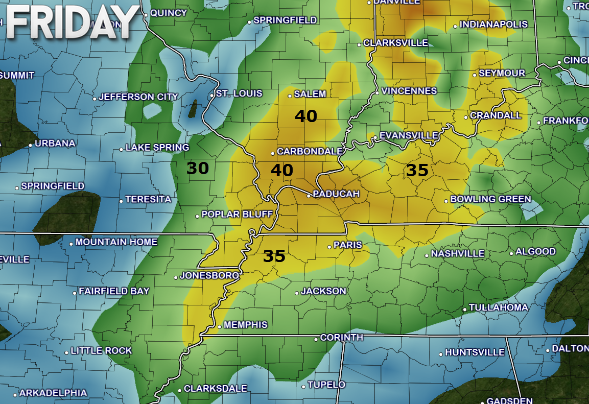
Rainfall totals over our northern counties should be fairly light. Less than 0.30″. Rainfall totals over parts of the Missouri Bootheel into western Kentucky/Tennessee could be a bit more. Some of the data shows 0.30″-0.60″. I will post a rainfall map further down in this update.
Still some time for adjustments on the rainfall totals.
Colder by Monday into the middle of next week.
I am watching a storm system for Tuesday/Wednesday of next week. Right now it is forecast to track to our south and east. But, shifts could still occur in the eventual track.

No snow or ice expected through Monday

Friday – No snow or ice anticipated.
Saturday – No snow or ice anticipated.
Sunday – No snow or ice anticipated.
Monday – No snow or ice anticipated.
Tuesday – Currently no snow or ice anticipated.

No major changes in this forecast update.

The only concern I have is patchy fog over the coming days.
Windy on Friday with gusts of 30-50 mph possible.


The wild card will be rainfall totals this coming weekend. Shower chances ramp up on Saturday night into Sunday. A few guidance packages bring a shower into the region on Saturday. But, I believe the better chances will hold off until Saturday night/Sunday. Rainfall totals over our southern counties might be heavier than northern counties.

How much precipitation should we expect over the next few days?

Can we expect severe thunderstorms over the next 24 to 48 hours? Remember that a severe thunderstorm is defined as a thunderstorm that produces 58 mph winds or higher, quarter size hail or larger, and/or a tornado.
The thunderstorm threat level will be a ZERO on Friday
The thunderstorm threat level will be a ZERO on Saturday
The thunderstorm threat level will be a ONE on Saturday night
The thunderstorm threat level will be a ONE on Sunday
The thunderstorm threat level will be a ZERO on Monday

Here is the official 6-10 day and 8-14 day temperature and precipitation outlook. Check the date stamp at the top of each image (so you understand the time frame).
The forecast maps below are issued by the Weather Prediction Center (NOAA).


The latest 8-14 day temperature and precipitation outlook. Note the dates are at the top of the image. These maps DO NOT tell you how high or low temperatures or precipitation will be. They simply give you the probability as to whether temperatures or precipitation will be above or below normal.


Here are the current river stage forecasts. You can click your state and then the dot for your location. It will bring up the full forecast and hydrograph.
Click Here For River Stage Forecasts…

Who do you trust for your weather information and who holds them accountable?
I have studied weather in our region since the late 1970’s. I have 37 years of experience in observing our regions weather patterns. My degree is in Broadcast Meteorology from Mississippi State University and an Associate of Science (AS). I am currently working on my Bachelor’s Degree in Geoscience.
My resume includes:
Member of the American Meteorological Society.
NOAA Weather-Ready Nation Ambassador.
Meteorologist for McCracken County Emergency Management. I served from 2005 through 2015.
I own and operate the Southern Illinois Weather Observatory.
Recipient of the Mark Trail Award, WPSD Six Who Make A Difference Award, Kentucky Colonel, and the Caesar J. Fiamma” Award from the American Red Cross.
In 2009 I was presented with the Kentucky Office of Highway Safety Award.
Recognized by the Kentucky House of Representatives for my service to the State of Kentucky leading up to several winter storms and severe weather outbreaks.
I am also President of the Shadow Angel Foundation which serves portions of western Kentucky and southern Illinois.
There is a lot of noise on the internet. A lot of weather maps are posted without explanation. Over time you should learn who to trust for your weather information.
My forecast philosophy is simple and straight forward.
- Communicate in simple terms
- To be as accurate as possible within a reasonable time frame before an event
- Interact with you on Twitter, Facebook, and the blog
- Minimize the “hype” that you might see on television or through other weather sources
- Push you towards utilizing wall-to-wall LOCAL TV coverage during severe weather events
I am a recipient of the Mark Trail Award, WPSD Six Who Make A Difference Award, Kentucky Colonel, and the Caesar J. Fiamma” Award from the American Red Cross. In 2009 I was presented with the Kentucky Office of Highway Safety Award. I was recognized by the Kentucky House of Representatives for my service to the State of Kentucky leading up to several winter storms and severe weather outbreaks.
If you click on the image below you can read the Kentucky House of Representatives Resolution.

Many of my graphics are from www.weatherbell.com – a great resource for weather data, model data, and more


You can sign up for my AWARE email by clicking here I typically send out AWARE emails before severe weather, winter storms, or other active weather situations. I do not email watches or warnings. The emails are a basic “heads up” concerning incoming weather conditions.