We have some great sponsors for the Weather Talk Blog. Please let our sponsors know that you appreciate their support for the Weather Talk Blog.
Milner and Orr Funeral Home and Cremation Services located in Paducah, Kentucky and three other western Kentucky towns – at Milner and Orr they believe in families helping families. You can find Milner and Orr on Facebook, as well.
![]()
.

For all of your families eye care needs. Visit their web-site here. Or, you can also visit their Facebook page.
.

Best at Enabling Body Shop Profitability since 1996. Located In Paducah Kentucky and Evansville Indiana; serving all customers in between. They provide Customer Service, along with all the tools necessary for body shops to remain educated and competitive. Click the logo above for their main web-site. You can find McClintock Preferred Finishes on Facebook, as well
.

Duck/goose decoys? Game calls? Optics? We have you covered! Click the logo above or visit Final Flight on Facebook, as well.
.
I have launched the new weather texting service! I could use your help. Be sure and sign up and fully support all of the weather data you see each day.
This is a monthly subscription service. Supporting this helps support everything else. The cost is $3 a month for one phone, $5 a month for three phones, and $10 a month for seven phones.
For more information visit BeauDodsonWeather.com
Or directly sign up at Weathertalk.com


This forecast update covers far southern Illinois, far southeast Missouri, and far western Kentucky. See the coverage map on the right side of the blog.
Remember that weather evolves. Check back frequently for updates, especially during active weather.

Winter Weather Radars
WEATHER RADAR PAGE – Click here —
UPDATE:
Snow never did change to rain over parts of southern Illinois and northwest Kentucky. Some slushy accumulation is occurring where the snow is coming down heavy.
Temperatures tonight will drop below freezing. Icy road conditions will be possible in areas that picked up a slushy inch or two of snow.
Use care
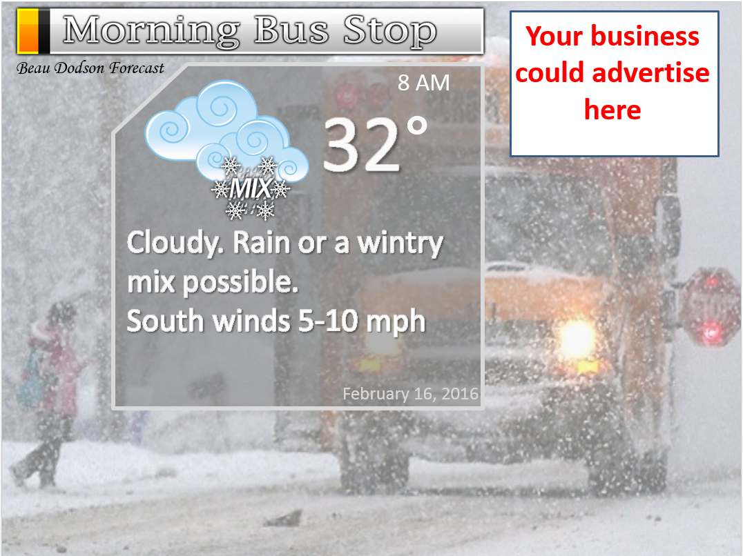
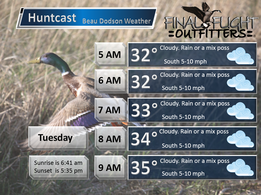
Monday Night – Cloudy early. Then, rain, sleet, freezing rain, snow or mix developing late tonight from the northwest towards the southeast. Better chances for all rain over southeast Missouri. Better chances for a mix over an area from near Farmington, Missouri into southern Illinois and western Kentucky. Low confidence on temperature profiles for this system.
Temperatures: Lows in the upper 20s to lower 30s.
Winds: South winds to variable winds at 0-5 mph.
What is the chance for precipitation? 50%
Coverage of precipitation? Scattered before 3 am and then increasing coverage after 3 am.
My confidence in this part of the forecast verifying is Medium
Should I be concerned about snow or ice? Wintry mix possible late tonight.
Should I cancel my outdoor plans? No
Is severe weather expected? No
What impact is expected? Maybe slick roads if temperatures were to fall below freezing.
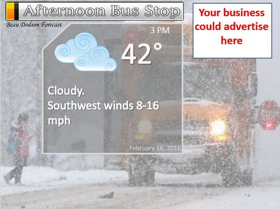
Tuesday – WIDE range of weather over our region on Tuesday. A morning chance of rain or rain/snow mix over southeast Missouri and then becoming partly cloudy during the afternoon hours. A chance for rain and rain/snow/wintry mix over southern Illinois and western Kentucky Tuesday morning. Tapering off late morning into the afternoon hours. Northwest Tennessee will have a chance for rain or rain/snow mix in the morning.
Temperatures: Highs upper 40s to lower 50s near Poplar Bluff, The Missouri Bootheel, and northwest Tennessee. Temperatures decreasing to upper 30s and lower 40s over southern Illinois and western Kentucky.
Winds: West/southwest winds at 8-16 mph. Gusty winds at times during the afternoon.
What is the chance for precipitation? 40% over southeast Missouri and northwest Tennessee. 70% over southern Illinois and northwest Kentucky.
Coverage of precipitation? Scattered to widespread
My confidence in this part of the forecast verifying is High
Should I be concerned about snow or ice? Some snow or wintry mix possible on Tuesday morning.
Should I cancel my outdoor plans? No
Is severe weather expected? No
What impact is expected? Will need to monitor the timing of precipitation on Tuesday morning. Some slick roads can’t be ruled out before temperatures rise above freezing.
Tuesday Night – Some clouds. Fog possible.
Temperatures: Lows in the upper 20s to lower 30s.
Winds: West winds at 10 mph
What is the chance for precipitation? 0%
Coverage of precipitation? None
My confidence in this part of the forecast verifying is High
Should I be concerned about snow or ice? No
Should I cancel my outdoor plans? No
Is severe weather expected? No
What impact is expected? None
Wednesday – Morning fog possible Some clouds. Not too bad for February.
Temperatures: Highs in the 46 to 54 degree range.
Winds: West/southwest winds at 5-10 mph.
What is the chance for precipitation? 0%
Coverage of precipitation? None
My confidence in this part of the forecast verifying is High
Should I be concerned about snow or ice? No
Should I cancel my outdoor plans? No
Is severe weather expected? No
What impact is expected? None
Wednesday Night – Partly cloudy. Fog possible.
Temperatures: Lows in the upper 20s to lower 30s.
Winds: Variable winds at 5 mph
What is the chance for precipitation? 0%
Coverage of precipitation? None
My confidence in this part of the forecast verifying is High
Should I be concerned about snow or ice? No
Should I cancel my outdoor plans? No
Is severe weather expected? No
What impact is expected? None
Thursday – Morning fog possible. Some clouds. Warm. Breezy at times.
Temperatures: Highs in the 54 to 58 degree range.
Winds: East winds at 8-16 mph.
What is the chance for precipitation? 0%
Coverage of precipitation? None
My confidence in this part of the forecast verifying is High
Should I be concerned about snow or ice? No
Should I cancel my outdoor plans? No
Is severe weather expected? No
What impact is expected? None
Thursday Night – Partly cloudy. Mild. Breezy at times.
Temperatures: Lows in the upper 40s to around 50 degrees!
Winds: South winds at 8-16 mph.
What is the chance for precipitation? 0%
Coverage of precipitation? None
My confidence in this part of the forecast verifying is High
Should I be concerned about snow or ice? No
Should I cancel my outdoor plans? No
Is severe weather expected? No
What impact is expected? None
Friday – Partly cloudy. Warm for February. Breezy.
Temperatures: Highs in the 64-68 degree range.
Winds: South and southwest winds at 10-20 mph and gusty.
What is the chance for precipitation? 0%
Coverage of precipitation? None
My confidence in this part of the forecast verifying is High
Should I be concerned about snow or ice? No
Should I cancel my outdoor plans? No
Is severe weather expected? No
What impact is expected? None
Mild Saturday and Sunday. Highs in the upper 50s to middle 60s. Perhaps increasing clouds on Sunday with a chance for showers.

Don’t forget to check out the Southern Illinois Weather Observatory web-site for weather maps, tower cams, scanner feeds, radars, and much more! Click here

An explanation of what is happening in the atmosphere over the coming days…
Highlights
1. Clipper system moving into the region on Monday night/Tuesday
2. MUCH MUCH warmer later this week
3. Is winter over?
We have a couple of weather stories to follow over the coming days. The biggest story will be near record warmth later this week. But, first we have another clipper diving into the region from the northwest.
Precipitation will push out of Iowa and Missouri later tonight into Tuesday morning. It will rapidly dive south and east into the morning hours. Typically these systems are fast movers. And, this one will be no different.
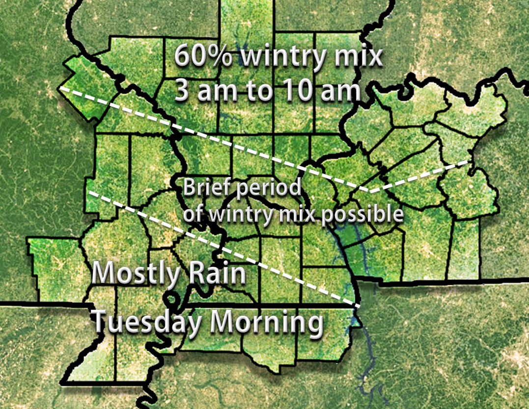
Widespread rain and rain/snow rain/wintry mix is forecast to push into our northern and northwestern counties after 2 AM Tuesday morning. The bulk of the precipitation will probably fall between 4 am and 12 pm on Tuesday morning.
Temperatures are forecast to dip below freezing tonight. Freezing rain could be a concern. There is a significant warm layer aloft with this system. That means that snowflakes might melt on their way down and then refreeze as surface temperatures are below freezing.
Snow chances would probably be limited to the Mt Vernon, IL area into southeast Illinois. Although even in those areas temperatures aloft may be too warm for snow. Thus, ice would be the primary concern.
If you have travel plans late Monday night into Tuesday morning then monitor updates.
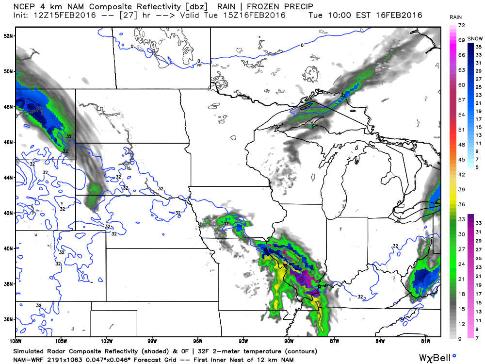
Here is the future-cast radar from weatherbell.com
This is the NAM/WRF model
Green is rain. Purple is wintry mix. Blue is snow. You can see that parts of our region are all of the above. That means the model really is not sure what type of precipitation will fall.
This is the 2 am to 4 am time frame. You can see precipitation moving in from the northwest. It is moving southeast.
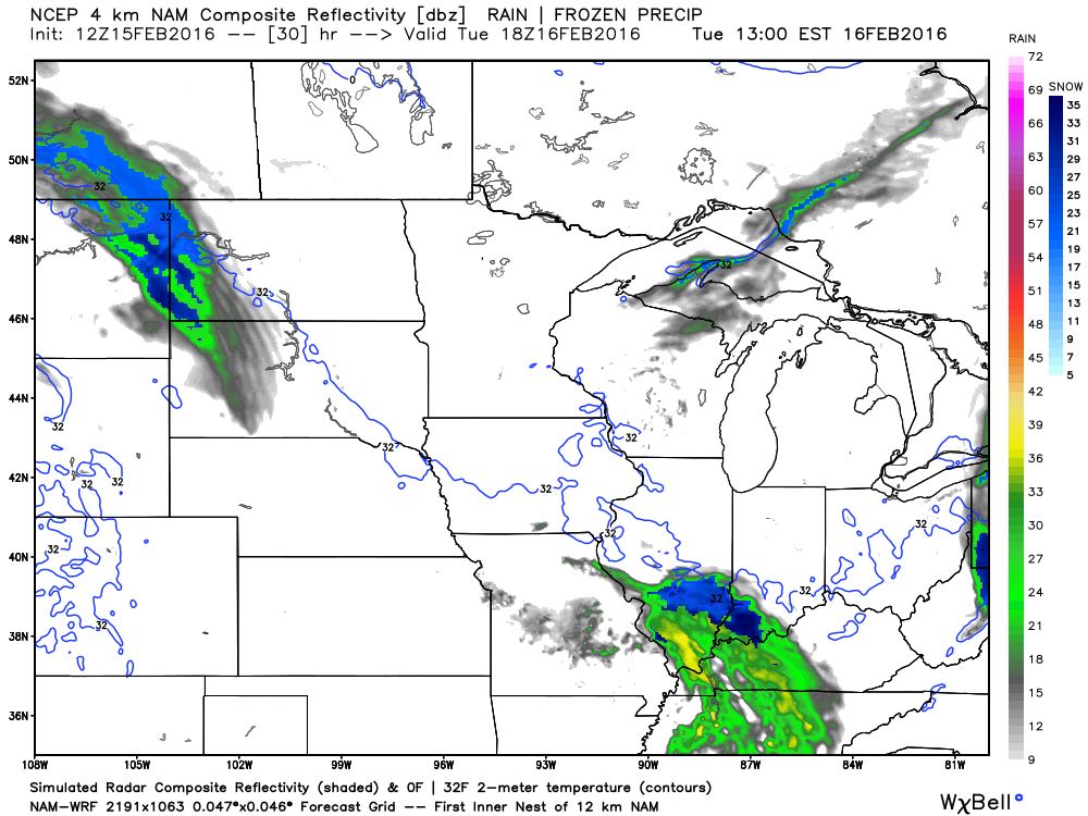
This is the 5 am to 7 am time frame.
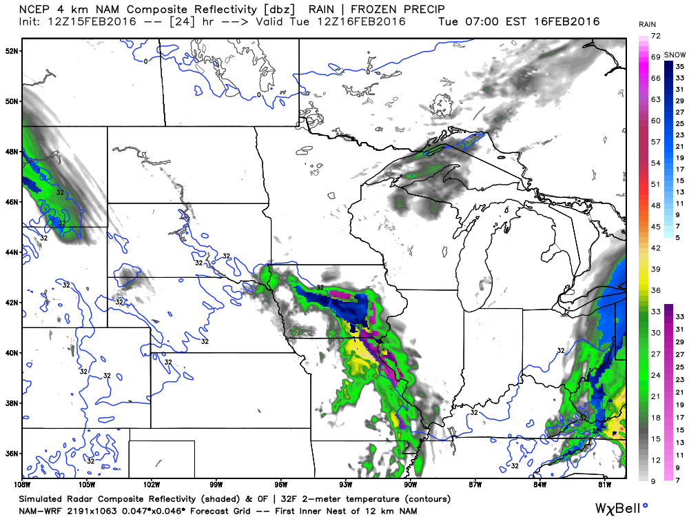
This is the 7 am to 9 am time frame.
And, this is the 11 am to 1 pm time frame.
Temperatures are forecast to rise during the morning hours. If this does start out as a wintry mix then it should change to rain by mid or late morning. Again, some question marks on precipitation type. Especially true the further north and east you travel in our region.
WARM UP IS ON THE WAY!!!!
The next BIG story will be a huge warm up later this week. By Thursday, Friday, and Saturday temperatures are forecast to rise into the 50s/60s. What a difference one week makes.

Yes, you can mail me some chocolate chip cookies for that one. 🙂
And, it is official. A car wash watch has been issued for Thursday-Saturday.
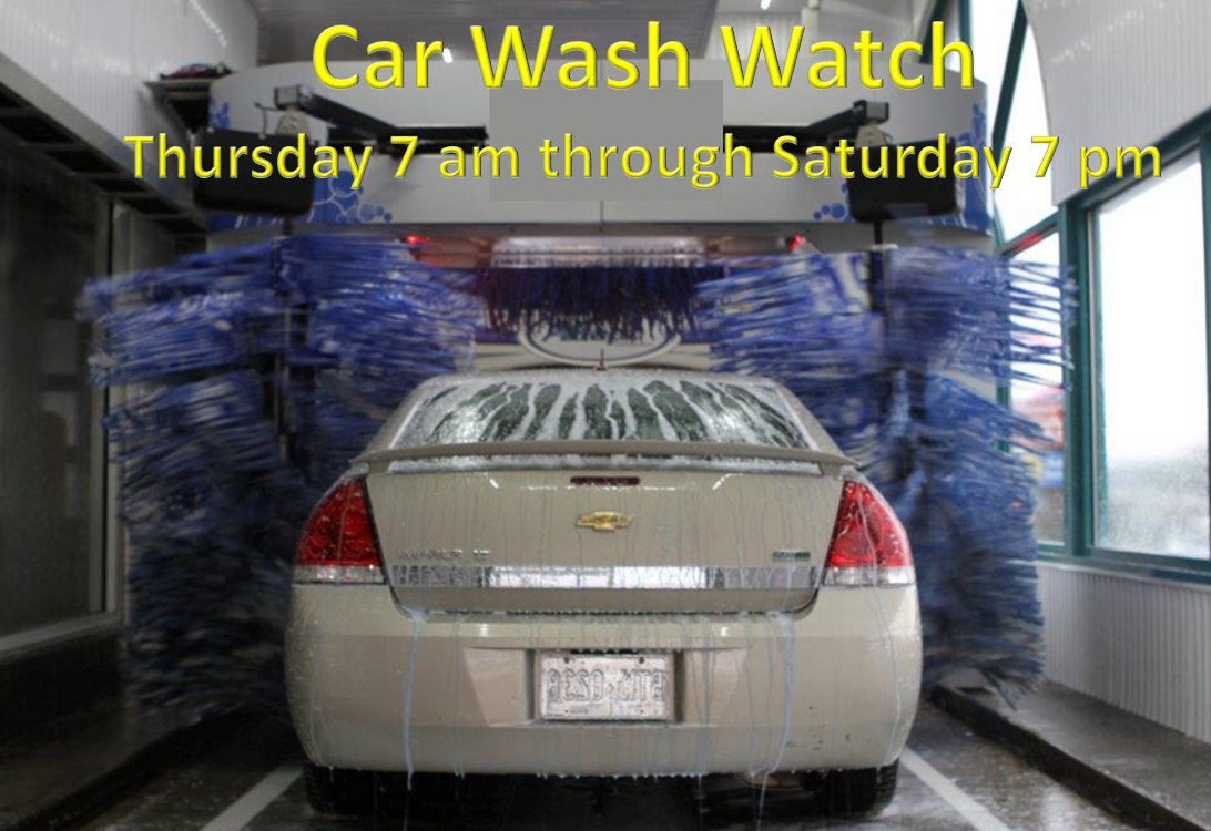
I suspect everyone will enjoy the break. Car washes will be busy as beavers! People will open their windows and let some fresh air into the house. I doubt there will be many complaints about the weather later this week.
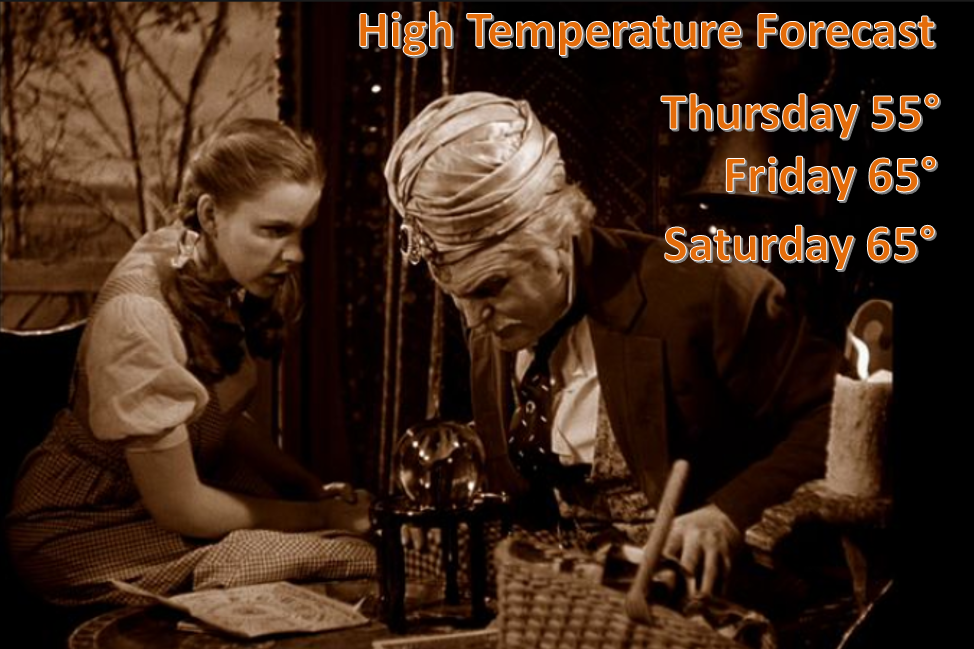
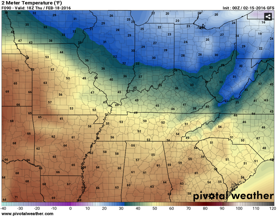
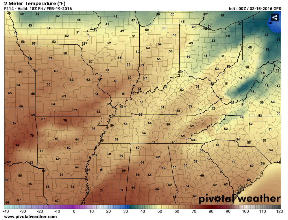
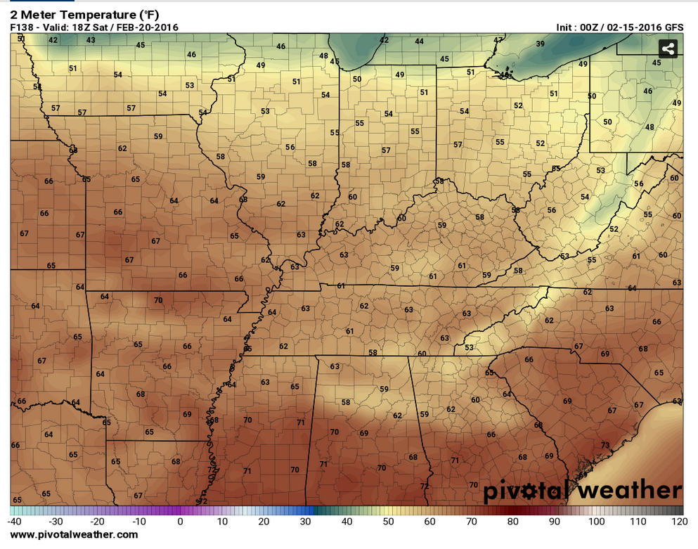
Here are the temperature forecast numbers for 12 pm on Thursday, 12 pm on Friday, and 12 pm on Saturday. Temperatures will rise a few more degrees during the afternoon hours. You get the general idea. Spring fever might take hold?
Thursday Noon Temperatures
Friday Noon Temperatures
Saturday Noon Temperatures
I will be watching for perhaps some showers or even a thunderstorm around Sunday or Monday. Long way off. Plenty of time to monitor that time frame. A cold front is forecast to push into the area from the north over the weekend. Then, perhaps return as a warm front.
Is winter over?
My thinking is that winter is not over. We still have more to go.
Long range charts show multiple pushes of cold air over the next 2-4 weeks. Could we still have more snow and ice? Yes, we certainly could. I know some of you have had very little snow so far this winter. Especially true over southeast Missouri and southwest Illinois. I would not give up yet.
Did you know that the Paducah, Kentucky NWS is only one inch shy of reaching a top ten snowiest winters? Hard to believe for those of you who have missed out on most of the snow events. Location, location, location. I say it all the time. Winter storm tracks are KEY to how much snow falls at any given location.
Yes, with each passing day and with each passing week we draw closer to spring. We will trade the snow and ice for thunderstorms. Let’s enjoy the season at hand.

A clipper system moving into the region from the northwest on Monday night and Tuesday morning could produce a rain rain/snow wintry mix over parts of southeast Missouri into southern Illinois and west Kentucky. Freezing rain could cause roads to become slick late tonight into early Tuesday morning. Temperatures should rise above freezing by mid or late morning on Tuesday.

Monday night – Rain and/or a wintry mix possible late tonight into Tuesday morning.
Tuesday – Wintry mix possible in the morning.
Wednesday – No snow or ice anticipated.
Thursday – No snow or ice anticipated.
Friday – No snow or ice anticipated.
Saturday – No snow or ice anticipated.
Sunday – No snow or ice anticipated.

Adjustment precipitation probabilities for Monday night/Tuesday morning.

Main concern will be ice late tonight into Tuesday morning. Use care if you have to drive late tonight into Tuesday morning. Temperatures should rise above freezing around mid morning on Tuesday.


The wild card in this forecast will be the incoming storm system on Monday night and Tuesday morning. Will it be rain, freezing rain, or snow. Perhaps all three. Warm layer aloft indicates ice is possible on Tuesday morning.
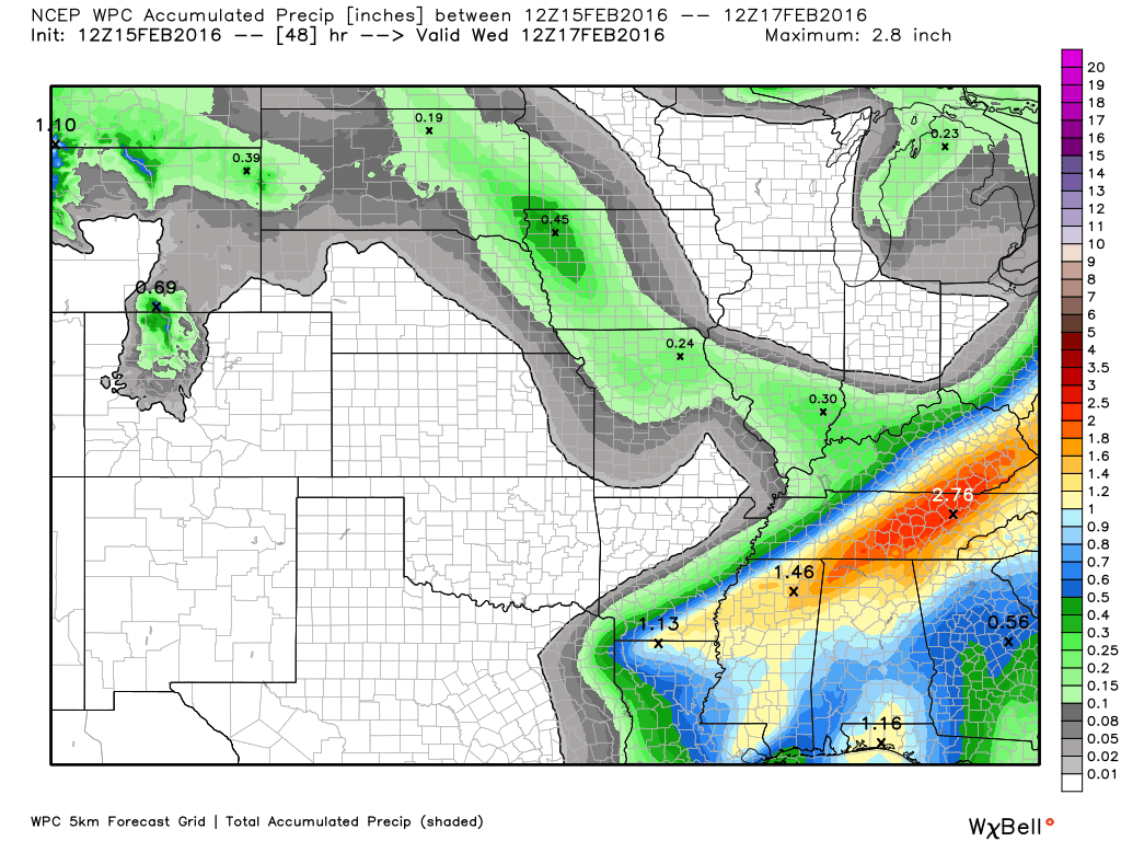
 How much precipitation should we expect over the next few days?
Rain or a mix of rain/snow will push back into the region on Monday night and especially on Tuesday morning. Right now this appears to mostly be a rain system. Rain totals will vary across the region. Best chances for 0.25″+ will be over southern Illinois and western Kentucky. Southeast Missouri should pick up 0.10″-0.25″.
Temperatures will be marginal for a wintry mix. Believe impacts would be minimal. But, let’s keep an eye on it. Occasionally dynamic systems like this can produce a burst of heavy/wet snow.
Official precipitation forecast numbers for this event. This is through Tuesday afternoon. Precipitation will end during that time frame. The next chance of rain should hold off until later this weekend.

Can we expect severe thunderstorms over the next 24 to 48 hours? Remember that a severe thunderstorm is defined as a thunderstorm that produces 58 mph winds or higher, quarter size hail or larger, and/or a tornado.
The thunderstorm threat level will be a ZERO through Saturday. Some indications of a chance for thunderstorms around Sunday. Will monitor.

Here is the official 6-10 day and 8-14 day temperature and precipitation outlook. Check the date stamp at the top of each image (so you understand the time frame).
The forecast maps below are issued by the Weather Prediction Center (NOAA).


The latest 8-14 day temperature and precipitation outlook. Note the dates are at the top of the image. These maps DO NOT tell you how high or low temperatures or precipitation will be. They simply give you the probability as to whether temperatures or precipitation will be above or below normal.


Here are the current river stage forecasts. You can click your state and then the dot for your location. It will bring up the full forecast and hydrograph.
Click Here For River Stage Forecasts…

Who do you trust for your weather information and who holds them accountable?
I have studied weather in our region since the late 1970’s. I have 37 years of experience in observing our regions weather patterns. My degree is in Broadcast Meteorology from Mississippi State University and an Associate of Science (AS). I am currently working on my Bachelor’s Degree in Geoscience.
My resume includes:
Member of the American Meteorological Society.
NOAA Weather-Ready Nation Ambassador.
Meteorologist for McCracken County Emergency Management. I served from 2005 through 2015.
I own and operate the Southern Illinois Weather Observatory.
Recipient of the Mark Trail Award, WPSD Six Who Make A Difference Award, Kentucky Colonel, and the Caesar J. Fiamma” Award from the American Red Cross.
In 2009 I was presented with the Kentucky Office of Highway Safety Award.
Recognized by the Kentucky House of Representatives for my service to the State of Kentucky leading up to several winter storms and severe weather outbreaks.
I am also President of the Shadow Angel Foundation which serves portions of western Kentucky and southern Illinois.
There is a lot of noise on the internet. A lot of weather maps are posted without explanation. Over time you should learn who to trust for your weather information.
My forecast philosophy is simple and straight forward.
- Communicate in simple terms
- To be as accurate as possible within a reasonable time frame before an event
- Interact with you on Twitter, Facebook, and the blog
- Minimize the “hype” that you might see on television or through other weather sources
- Push you towards utilizing wall-to-wall LOCAL TV coverage during severe weather events
I am a recipient of the Mark Trail Award, WPSD Six Who Make A Difference Award, Kentucky Colonel, and the Caesar J. Fiamma” Award from the American Red Cross. In 2009 I was presented with the Kentucky Office of Highway Safety Award. I was recognized by the Kentucky House of Representatives for my service to the State of Kentucky leading up to several winter storms and severe weather outbreaks.
If you click on the image below you can read the Kentucky House of Representatives Resolution.

Many of my graphics are from www.weatherbell.com – a great resource for weather data, model data, and more


You can sign up for my AWARE email by clicking here I typically send out AWARE emails before severe weather, winter storms, or other active weather situations. I do not email watches or warnings. The emails are a basic “heads up” concerning incoming weather conditions.