We have some great sponsors for the Weather Talk Blog. Please let our sponsors know that you appreciate their support for the Weather Talk Blog.
Milner and Orr Funeral Home and Cremation Services located in Paducah, Kentucky and three other western Kentucky towns – at Milner and Orr they believe in families helping families. You can find Milner and Orr on Facebook, as well.
![]()
.

For all of your families eye care needs. Visit their web-site here. Or, you can also visit their Facebook page.
.

Best at Enabling Body Shop Profitability since 1996. Located In Paducah Kentucky and Evansville Indiana; serving all customers in between. They provide Customer Service, along with all the tools necessary for body shops to remain educated and competitive. Click the logo above for their main web-site. You can find McClintock Preferred Finishes on Facebook, as well
.

Duck/goose decoys? Game calls? Optics? We have you covered! Click the logo above or visit Final Flight on Facebook, as well.
.
I have launched the new weather texting service! I could use your help. Be sure and sign up and fully support all of the weather data you see each day.
This is a monthly subscription service. Supporting this helps support everything else. The cost is $3 a month for one phone, $5 a month for three phones, and $10 a month for seven phones.
For more information visit BeauDodsonWeather.com
Or directly sign up at Weathertalk.com


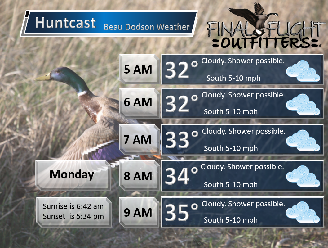
This forecast update covers far southern Illinois, far southeast Missouri, and far western Kentucky. See the coverage map on the right side of the blog.
Remember that weather evolves. Check back frequently for updates, especially during active weather.

Winter Weather Radars
WEATHER RADAR PAGE – Click here —
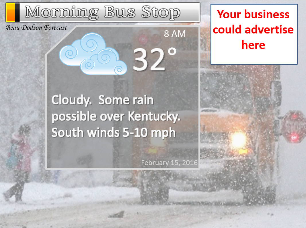
Sunday Night – Patchy freezing drizzle or light freezing rain may continue well into the night. Temperatures may rise after midnight.
Temperatures: Lows from 25-30 degrees. Temperatures may rise after midnight.
Winds: Southeast winds at 5-10 mph turning more southerly late
What is the chance for precipitation? 40% early. 60% near the KY/TN line.
Coverage of precipitation? Coming to an end from west to east
My confidence in this part of the forecast verifying is High
Should I be concerned about snow or ice? Some light freezing drizzle possible.
Should I cancel my outdoor plans? Slick roads likely on Sunday night.
Is severe weather expected? No
What impact is expected? Slick roads likely.
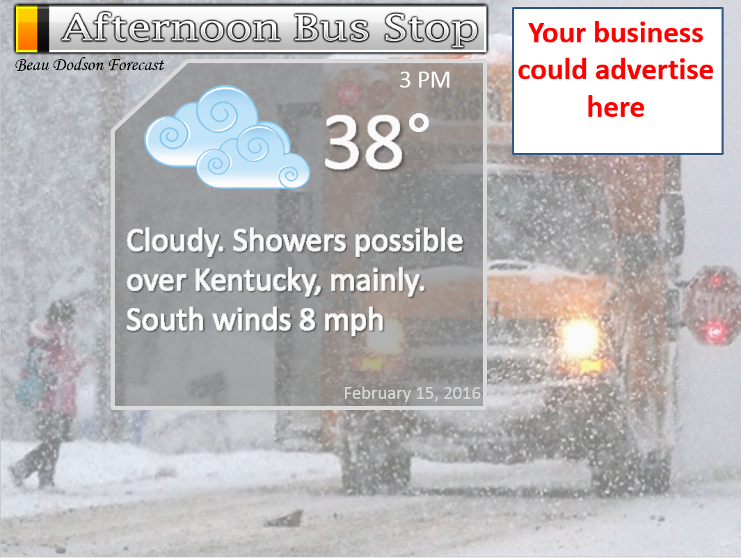
Monday – Cloudy. A 20% chance of a morning wintry mix. Then rain possible over western Kentucky and western Tennessee. A few scattered showers perhaps over southeast Missouri and southern Illinois. Monday’s precipitation will mostly be further south and east. Milder.
Temperatures: Rising temperatures into the 30s to perhaps even lower 40s.
Winds: South winds at 5-10 mph. Variable winds, at times.
What is the chance for precipitation? 20%-30% over MO/IL and 40%-60% over Kentucky and Tennessee. Better chances the further south and east you travel.
Coverage of precipitation? Some rain possible over western Kentucky.
My confidence in this part of the forecast verifying is High
Should I be concerned about snow or ice? Believe most of the wintry precipitation will have ended. Will need to monitor the KY/TN border counties and southeast Missouri (early in the day).
Should I cancel my outdoor plans? Morning travel may be disrupted by slick roads.
Is severe weather expected? No
What impact is expected? Slick roadways will be possible on Monday morning. Rising temps should help road conditions during the afternoon.
Monday Night – Cloudy. A chance for light rain or light rain/snow/freezing drizzle mix.
Temperatures: Lows in the upper 20s to lower 30s.
Winds: Southwest winds at 10 mph
What is the chance for precipitation? 30%
Coverage of precipitation? Scattered
My confidence in this part of the forecast verifying is Medium
Should I be concerned about snow or ice? Maybe some light rain/snow mix late at night.
Should I cancel my outdoor plans? No
Is severe weather expected? No
What impact is expected? Maybe slick roads if temperatures were to fall below freezing.
Tuesday – Quite a few clouds. Some showers possible.
Temperatures: Highs in the 46 to 54 degree range.
Winds: West/southwest winds at 8-16 mph.
What is the chance for precipitation? 40%
Coverage of precipitation? Scattered
My confidence in this part of the forecast verifying is High
Should I be concerned about snow or ice? No
Should I cancel my outdoor plans? No
Is severe weather expected? No
What impact is expected? If no snow or ice develops on Monday night then no impacts.
Tuesday Night – Some clouds.
Temperatures: Lows in the upper 20s to lower 30s.
Winds: West winds at 10 mph
What is the chance for precipitation? 10%
Coverage of precipitation? None
My confidence in this part of the forecast verifying is High
Should I be concerned about snow or ice? No
Should I cancel my outdoor plans? No
Is severe weather expected? No
What impact is expected? None
Wednesday – Partly cloudy. Not too bad for February.
Temperatures: Highs in the 46 to 54 degree range.
Winds: West/southwest winds at 8-16 mph.
What is the chance for precipitation? 0%
Coverage of precipitation? None
My confidence in this part of the forecast verifying is High
Should I be concerned about snow or ice? No
Should I cancel my outdoor plans? No
Is severe weather expected? No
What impact is expected? None
We rise into the 50s and 60s on Thursday and Friday. Mild!!

Don’t forget to check out the Southern Illinois Weather Observatory web-site for weather maps, tower cams, scanner feeds, radars, and much more! Click here

An explanation of what is happening in the atmosphere over the coming days…
Highlights
1. Our Valentines Day snow, sleet, and freezing rain is coming to an end.
2. Additional rain possible on Monday and Tuesday?
3. MUCH warmer later this week!!!
Snow, sleet, and freezing rain spread across the region on Saturday night (late). Precipitation ramped up quickly early Sunday morning. There were numerous reports of thundersnow in the area. This is not all that common, but it isn’t rare. Typically occurs with dynamic systems.
Most areas picked up 1/2″-3″ of snow. Eastern counties had a bit more. This is where the cold air was deeper. More of the atmosphere was below freezing. Thus, mostly snow fell.
Freezing rain and sleet mixed in over much of southeast Missouri, far southern Illinois, and western Kentucky, northwest Tennessee. This helped keep snow totals down, somewhat. All in all the forecast panned out about as anticipated. There are always some spots that end up with more. Some spots end up with less. Nature of the beast when it comes to winter storms.
Almost every road in the region was snow and ice covered on Sunday morning.
Here was my forecast map.
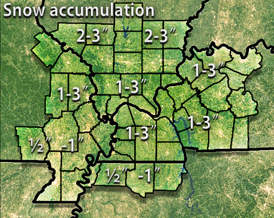
Here is what I thought might fall if sleet DID NOT mix in. Eastern counties.
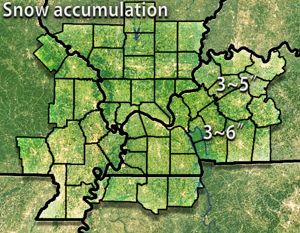
And, here is what was reported. Areas with no numbers did not report in. They still had snow/ice. I just didn’t have any information from that county.

Over the next 24 hours I will be monitoring two things. One is the freezing line. The freezing line will advance northward later tonight. Slowly, but surely moving north across the Missouri Bootheel into western Tennessee. And, by Monday morning, it should be into parts of western Kentucky. How fast the freezing line shifts northward will be the determining factor as to how much roads improve on Monday morning.
Plan on icy roads into Sunday night and Monday morning.
Temperatures are forecast to rise above freezing everywhere on Monday. This should help clear the roads. Some areas over southeast Missouri, western Tennessee, and perhaps western Kentucky could hit 40 degrees.
Rain is possible on Monday over western Tennessee and western Kentucky. This will be in response to a second system moving to our south. Rainfall totals should not be heavy.
On Monday night/Tuesday a clipper system will dive down from the northwest. This could spread light rain or a rain/snow/freezing drizzle mix back into the region. Some questions remain on temperatures Monday night.
Perhaps some showers on Tuesday from the above mentioned clipper.
Temperatures warm up on Tuesday into the rest of the week. Everyone should reach into the 50s on Thursday and Friday. And, 60s will even be possible. Imagine that. Say goodbye to the snow cover!

Sunday night – Some wintry mix could continue into the evening hours over western Kentucky. Ending elsewhere.
Monday – Rain is possible.
Tuesday – Small chance late Monday night and Tuesday of a rain/snow mix. Maybe freezing drizzle.

Sunday night – Snow, sleet, and freezing rain should come to an end over the region. Lingering longer near the KY/TN border counties and eastern counties. East of Kentucky Lake.
Monday – We should go above freezing. This will change whatever precipitation is left over to rain.
Tuesday – Small chance for morning snow showers or wintry mix.
Wednesday – No snow or ice anticipated.
Thursday – No snow or ice anticipated.

No significant changes to the forecast.

Hazardous roads are my main concern.

Slick roads into Sunday night and Monday morning. Roads will improve on Monday as temperatures rise above freezing.

The wild card for Sunday night will be the freezing line. How far north can it push tonight into early Monday morning. It does appear it should make some headway northward. But, not sure it will be fast enough to clear up roads. Especially true in areas with quite a bit of snow or sleet on the ground.
 How much precipitation should we expect over the next few days?
Much of the area will be dry on Monday. But, areas along the Kentucky and Tennessee border could see another surge of precipitation. This time it is forecast to be rain. Some question as to how far north the rain shield will edge. Keep that in mind.
Areas that do receive rain could pick up another 0.20″-0.50″. Again, some question on how far north the rain will push.
Light showers possible on Tuesday, as well.

Can we expect severe thunderstorms over the next 24 to 48 hours? Remember that a severe thunderstorm is defined as a thunderstorm that produces 58 mph winds or higher, quarter size hail or larger, and/or a tornado.
The thunderstorm threat level will be a ZERO through next Wednesday.

Here is the official 6-10 day and 8-14 day temperature and precipitation outlook. Check the date stamp at the top of each image (so you understand the time frame).
The forecast maps below are issued by the Weather Prediction Center (NOAA).


The latest 8-14 day temperature and precipitation outlook. Note the dates are at the top of the image. These maps DO NOT tell you how high or low temperatures or precipitation will be. They simply give you the probability as to whether temperatures or precipitation will be above or below normal.


Here are the current river stage forecasts. You can click your state and then the dot for your location. It will bring up the full forecast and hydrograph.
Click Here For River Stage Forecasts…

Who do you trust for your weather information and who holds them accountable?
I have studied weather in our region since the late 1970’s. I have 37 years of experience in observing our regions weather patterns. My degree is in Broadcast Meteorology from Mississippi State University and an Associate of Science (AS). I am currently working on my Bachelor’s Degree in Geoscience.
My resume includes:
Member of the American Meteorological Society.
NOAA Weather-Ready Nation Ambassador.
Meteorologist for McCracken County Emergency Management. I served from 2005 through 2015.
I own and operate the Southern Illinois Weather Observatory.
Recipient of the Mark Trail Award, WPSD Six Who Make A Difference Award, Kentucky Colonel, and the Caesar J. Fiamma” Award from the American Red Cross.
In 2009 I was presented with the Kentucky Office of Highway Safety Award.
Recognized by the Kentucky House of Representatives for my service to the State of Kentucky leading up to several winter storms and severe weather outbreaks.
I am also President of the Shadow Angel Foundation which serves portions of western Kentucky and southern Illinois.
There is a lot of noise on the internet. A lot of weather maps are posted without explanation. Over time you should learn who to trust for your weather information.
My forecast philosophy is simple and straight forward.
- Communicate in simple terms
- To be as accurate as possible within a reasonable time frame before an event
- Interact with you on Twitter, Facebook, and the blog
- Minimize the “hype” that you might see on television or through other weather sources
- Push you towards utilizing wall-to-wall LOCAL TV coverage during severe weather events
I am a recipient of the Mark Trail Award, WPSD Six Who Make A Difference Award, Kentucky Colonel, and the Caesar J. Fiamma” Award from the American Red Cross. In 2009 I was presented with the Kentucky Office of Highway Safety Award. I was recognized by the Kentucky House of Representatives for my service to the State of Kentucky leading up to several winter storms and severe weather outbreaks.
If you click on the image below you can read the Kentucky House of Representatives Resolution.

Many of my graphics are from www.weatherbell.com – a great resource for weather data, model data, and more


You can sign up for my AWARE email by clicking here I typically send out AWARE emails before severe weather, winter storms, or other active weather situations. I do not email watches or warnings. The emails are a basic “heads up” concerning incoming weather conditions.