We have some great sponsors for the Weather Talk Blog. Please let our sponsors know that you appreciate their support for the Weather Talk Blog.
Milner and Orr Funeral Home and Cremation Services located in Paducah, Kentucky and three other western Kentucky towns – at Milner and Orr they believe in families helping families. You can find Milner and Orr on Facebook, as well.
![]()
.

Wortham Dental Care located in Paducah, Kentucky. The gentle dentist. Mercury free dentistry. They also do safe Mercury removal. You can find Wortham Dental Care on Facebook, as well
.

For all of your families eye care needs. Visit their web-site here. Or, you can also visit their Facebook page.
.

Endrizzi’s Storm Shelters – For more information click here. Endrizzi Contracting and Landscaping can be found on Facebook, as well – click here
.

Best at Enabling Body Shop Profitability since 1996. Located In Paducah Kentucky and Evansville Indiana; serving all customers in between. They provide Customer Service, along with all the tools necessary for body shops to remain educated and competitive. Click the logo above for their main web-site. You can find McClintock Preferred Finishes on Facebook, as well
.

Duck/goose decoys? Game calls? Optics? We have you covered! Click the logo above or visit Final Flight on Facebook, as well.

This forecast update covers far southern Illinois, far southeast Missouri, and far western Kentucky. See the coverage map on the right side of the blog.
Remember that weather evolves. Check back frequently for updates, especially during active weather.
Thursday night – Clouds. Small chance for a flurry. Cold.
Temperatures: Lows in the middle to upper 20s
Winds: West/northwest wind at 3-6 mph
What is the chance for precipitation? 0%
Coverage of precipitation? None
My confidence in this part of the forecast verifying is High
Should I be concerned about snow or ice? No
Should I cancel my outdoor plans? No
Is severe weather expected? No
What impact is expected? None
Friday – Morning clouds and cold. Small chance for a sprinkle or flurry. Some clearing in the afternoon.
Temperatures: Highs in the 36 to 44 degree range
Winds: West/northwest winds at 6-12 mph with gusts to 18 mph. Winds becoming more southwest/west during the afternoon and evening hours.
What is the chance for precipitation? 0%
Coverage of precipitation? None expected
My confidence in this part of the forecast verifying is High
Should I be concerned about snow or ice? No
Should I cancel my outdoor plans? No
Is severe weather expected? No
What impact is expected? None
Friday night – Mostly clear and cold. Some spots could dip colder than these readings.
Temperatures: Lows in the 22 to 26 degree range
Winds: West wind at 0-5 mph
What is the chance for precipitation? 0%
Coverage of precipitation? None
My confidence in this part of the forecast verifying is High
Should I be concerned about snow or ice? No
Should I cancel my outdoor plans? No
Is severe weather expected? No
What impact is expected? None
Saturday – Mostly sunny and cold.
Temperatures: Highs from 44 to 48 degrees.
Winds: West/southwest winds at 4-8 mph with gusts to 12 mph. Winds becoming more and more southwest during the afternoon hours.
What is the chance for precipitation? 0%
Coverage of precipitation? None expected
My confidence in this part of the forecast verifying is High
Should I be concerned about snow or ice? No
Should I cancel my outdoor plans? No
Is severe weather expected? No
What impact is expected? None
Saturday night – Mostly clear and cold.
Temperatures: Lows in the upper 20s to middle 30s
Winds: West/northwest wind at 3-6 mph. Winds becoming south/southwest late.
What is the chance for precipitation? 0%
Coverage of precipitation? None
My confidence in this part of the forecast verifying is High
Should I be concerned about snow or ice? No
Should I cancel my outdoor plans? No
Is severe weather expected? No
What impact is expected? None
Sunday – Quite a bit of sun in the morning. Increasing clouds in the afternoon. Windy at times.
Temperatures: Highs in the 48-54 degree range
Winds: Southwest winds at 10-20 mph.
What is the chance for precipitation? 0%
Coverage of precipitation? None expected
My confidence in this part of the forecast verifying is High
Should I be concerned about snow or ice? No
Should I cancel my outdoor plans? No
Is severe weather expected? No
What impact is expected? Gusty winds possible
Sunday night – Cloudy. A chance for showers.
Temperatures: Lows in the upper 40s to lower 50s
Winds: South winds at 8-16 mph
What is the chance for precipitation? 40%
Coverage of precipitation? Scattered
My confidence in this part of the forecast verifying is Medium
Should I be concerned about snow or ice? No
Should I cancel my outdoor plans? No, but monitor updates.
Is severe weather expected? No
What impact is expected? Wet roadways
Monday – Cloudy. A chance for showers.
Temperatures: Highs in the 55-60 degree range
Winds: Southwest winds at 10-20 mph.
What is the chance for precipitation? 40%-60%
Coverage of precipitation? Scattered to perhaps widespread
My confidence in this part of the forecast verifying is Medium
Should I be concerned about snow or ice? No
Should I cancel my outdoor plans? Have a plan B
Is severe weather expected? No
What impact is expected? Wet roadways.
Monday night – Some clouds. Perhaps a shower.
Temperatures: Lows in the middle 40s
Winds: West winds at 6-12 mph
What is the chance for precipitation? 20%
Coverage of precipitation? Isolated
My confidence in this part of the forecast verifying is Medium
Should I be concerned about snow or ice? No
Should I cancel my outdoor plans? No
Is severe weather expected? No
What impact is expected? None
Tuesday – Cloudy. Showers possible.
Temperatures: Highs in the 56 to 62 degree range
Winds: Southeast winds at 6-12 mph.
What is the chance for precipitation? 40% But, this could change. Depends on the track of the system.
Coverage of precipitation? Scattered
My confidence in this part of the forecast verifying is Medium
Should I be concerned about snow or ice? No
Should I cancel my outdoor plans? No
Is severe weather expected? No
What impact is expected? Possibly wet roadways
Tuesday night – Cloudy. A chance for some showers.
Temperatures: Lows in the 48 to 54 degree range
Winds: Southwest at 10 mph.
What is the chance for precipitation? 40% – 60%
Coverage of precipitation? Scattered
My confidence in this part of the forecast verifying is Medium
Should I be concerned about snow or ice? No
Should I cancel my outdoor plans? No, but have a plan B in mind. Some disagreement in guidance as to precipitation coverage.
Is severe weather expected? Monitor updates. Not likely.
What impact is expected? Wet roadways.
Wednesday – Cloudy. Rain likely. Perhaps a thunderstorm.
Temperatures: Highs in the 50s
Winds: Southwest at 10-20 mph. Gusty winds.
What is the chance for precipitation? 70%
Coverage of precipitation? Widespread
My confidence in this part of the forecast verifying is LOW
Should I be concerned about snow or ice? No
Should I cancel my outdoor plans? No, but have a plan B in mind. Some disagreement in guidance as to precipitation coverage.
Is severe weather expected? Monitor updates
What impact is expected? Wet roadways. Lightning possible.
Wednesday night – Cloudy. Showers possible. But, ending late.
Temperatures: Lows in the middle 40s to lower 50s
Winds: Southwest at 10 mph turning northwest at 6-12 mph
What is the chance for precipitation? 40% early (low confidence this far out)
Coverage of precipitation? Scattered
My confidence in this part of the forecast verifying is LOW
Should I be concerned about snow or ice? No
Should I cancel my outdoor plans? No, but have a plan B in mind. Some disagreement in guidance as to precipitation coverage.
Is severe weather expected? No
What impact is expected? Wet roads
Thursday – Some clouds. Cooler.
Temperatures: Highs in the 40s
Winds: Northwest winds at 5-10 mph.
What is the chance for precipitation? None (but, monitor updates)
Coverage of precipitation? None
My confidence in this part of the forecast verifying is LOW
Should I be concerned about snow or ice? No
Should I cancel my outdoor plans? No
Is severe weather expected? No
What impact is expected? None
Thursday night – Patchy clouds and colder
Temperatures: Lows in the 20s
Winds: Northwest at 5-10 mph with gusts to 15 mph
What is the chance for precipitation? 0%
Coverage of precipitation? None
My confidence in this part of the forecast verifying is LOW
Should I be concerned about snow or ice? No
Should I cancel my outdoor plans? No
Is severe weather expected? No
What impact is expected? None
Friday – Some clouds. Colder.
Temperatures: Highs in the upper 30s to lower 40s
Winds: Northwest at 5-10 mph
What is the chance for precipitation? 0%
Coverage of precipitation? None
My confidence in this part of the forecast verifying is LOW
Should I be concerned about snow or ice? No
Should I cancel my outdoor plans? No
Is severe weather expected? No
What impact is expected? None

Click their ad below to visit their web-site or click here reedelec.com


Don’t forget to check out the Southern Illinois Weather Observatory web-site for weather maps, tower cams, scanner feeds, radars, and much more! Click here

An explanation of what is happening in the atmosphere over the coming days…
Highlights
1. Weak system moves through Thursday night and Friday morning. Maybe a flurry
2. Warming trend Sunday through Christmas Eve
3. A very active 15 days ahead of us with multiple systems to watch
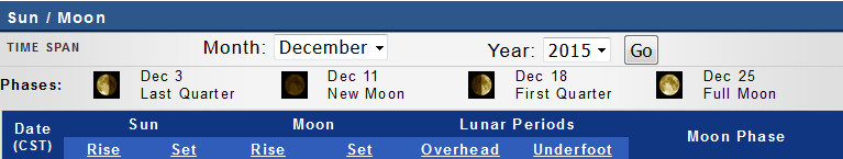
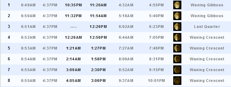
4. Let’s look at where we are at with December temperatures and precipitation.
Some clouds for your Thursday night and Friday morning as a weak storm system moves through the region. There could even be a novelty snow flurry. Nothing to write home about. Just a reminder that it is actually still December. This system will reinforce our cold air. Highs on Friday likely won’t reach 40 degrees. Brrr! Again, it will feel like winter, for once.
The cold snap will last into Saturday. A warming trend begins on Sunday and will last into next week. Sunday should deliver highs closer to 50-55 degrees. Near normal to above normal.
A series of storm systems will then impact our region starting on Sunday night and likely continuing into the end of the month. One system after another. They should be mostly rain. Warm air will ride up in front of each system. Then colder air behind.
It is a little murky as to just how many areas of low pressure we will deal with next week. Some of these systems spill into the next one. Keep that in mind. Doesn’t really change the actual forecast.
Whether one of these systems could produce a little light snow appears unlikely (at least through the 25th). Rain will be the dominant precipitation type.
Let’s take a look at each of the systems.
Let me say right now, it won’t rain ALL the time. And, there is disagreement among the guidance as to the exact timing of the systems between the 23rd and 28th. Keep that in mind.
The first one arrives Sunday night and Monday. Some showers will occur with this. The low passes way way north of us. No chance of snow with this one.

Then another system follows quickly on its heals.
This one arrives Tuesday night and Wednesday morning. Keep in mind that we are still a number of days out from this one. Timing will need to be adjusted.
More rain. Maybe even rumbles of thunder. GFS indicates a decent rain with this one.

Then another system quickly follows on Christmas Eve. This actually is part of the same system from Tuesday. Woosh is the weatherman going to have his hands full.
The low tracks just west of us. Thunderstorms can’t be ruled out. Let’s keep an eye on it.

Then another system shows up in the charts around December 27th. Talk about active, if true.

Then the models show that system continuing into the 28th. We will need to keep an eye on the track of this one. It does have some colder air to work with to our northwest. This is so far out that I would not have any confidence that there will even be a system.
The bottom line is that a very busy weather pattern is developing. Quite amazing just how many systems are showing up in the charts.

Using CIPS Analogs I can see that odds are almost 100% that next week will produce above normal rainfall. Some of the model guidance also indicates the potential for thunderstorms somewhere in the region around Christmas Eve. This will need to be monitored. Still too far out for details. But, it is something I have been watching for awhile.
Here is the CIPS analog map for next week. This map gives you an idea, based on past events, as to what might happen with a similar pattern. The numbers represent what the chances are for above normal precipitation.

During the same time period CIPS analogs indicate temperatures could average 4-8 degrees above normal. Next week could bring a couple of mild spells. Well above normal temperatures. But, that will come at a price. Clouds and rain. Perhaps thunderstorms.

DECEMBER, thus far
As you already know, December has been very mild. But, some of the maps being pumped out lately are just incredible. If you are a meteorologist or interested in weather then you already realize we are experiencing a very unusual event. Persistent and sustained warmth with high anomaly values.
Here is a national departure map. Very mild for the country as a whole. These are average temperature departures for the month, thus far. Typically 1-3 degree departures are considered fairly large. These numbers in the graph below are incredible.

For example, look at this average temperature departure map from December 8th through the 14th. Temperatures were anywhere from 10 to 21 degrees above normal over the Midwest. This is truly amazing.

Let’s look at the precipitation map from December 1st through the 15th. The heaviest band of precipitation was placed over central/eastern Kansas into Iowa and Wisconsin. That blue and purple band. That represents 3 to 4+ inches of rain. And, the month is just barely half over. Our region has experienced a few rain events. But, not as much rainfall as other areas. Anywhere from 0.50″ to 1.50″. Some spots did pick up a bit more over southeast Missouri.

This next map is full of red. This is the departure from normal temperature map for the month, thus far. Red, red, red. That represents above normal temperatures. Incredibly temperatures have been 6 to 10 degrees above normal. Those are amazing departures. December could be one of the warmest December’s in recorded history. It will certainly rank way up on the list.

Here is a zoomed in version of the above map. Just completely covered in red.

Let’s look at the departure from normal precipitation map since October 17th. We will be adding a lot of rain to this map over the coming weeks. When all is said and done, I suspect this map will indicate above normal precipitation for the entire region.

If we look at the latest soil moisture anomalies map. This shows that much of the Midwest into the Missouri Valley and upper Midwest are fairly wet. And, we will be adding a lot of rain over the coming weeks. So it would appear, at least.

Here is the latest 6-10 day temperature outlook. This is for December 22nd through the 26th. The deep red colors represent a 70%-90% chance for above normal temperatures during that time period. When averaged out.

The precipitation map, for the same time period, indicates odds favor above normal precipitation.

Pulling ahead to the 8-14 day temperature outlook. Again, odds favor above normal temperatures.

And, during that same time period, odds favor more above normal precipitation. Quite the amazing pattern. This is not a typical El Nino pattern for our region.


No snow anticipated.

Thursday night – Small chance for flurries
Friday – Stray flurry possible Friday morning
Saturday – No snow or ice anticipated.
Sunday – No snow or ice anticipated.
Monday – No snow or ice anticipated.

No major changes.

No major concerns!

No, fairly calm weather over the coming days.

The wild card in this forecast will be the small chance for snow flurries on Thursday night and Friday morning. Maybe a couple of stray flakes.

How much precipitation should we expect over the next few days?
No significant rain or snow through Sunday.

Can we expect severe thunderstorms over the next 24 to 48 hours? Remember that a severe thunderstorm is defined as a thunderstorm that produces 58 mph winds or higher, quarter size hail or larger, and/or a tornado.
The thunderstorm threat level will be a ZERO for Friday-Sunday
.
Friday: Severe weather is not anticipated.
Saturday: Severe weather is not anticipated.
Sunday: Severe weather is not anticipated.
Sunday Night – Monday: Some thunder possible
Tuesday – Monitor updates
Wednesday – Monitor updates
Thursday – Severe weather is not anticipated


We have regional radars and local city radars – if a radar does not seem to be updating then try another one. Occasional browsers need their cache cleared. You may also try restarting your browser. That usually fixes the problem. Occasionally we do have a radar go down. That is why I have duplicates. Thus, if one fails then try another one.
If you have any problems then please send me an email beaudodson@usawx.com
WEATHER RADAR PAGE – Click here —
We also have a new national interactive radar – you can view that radar by clicking here.
Local interactive city radars include St Louis, Mt Vernon, Evansville, Poplar Bluff, Cape Girardeau, Marion, Paducah, Hopkinsville, Memphis, Nashville, Dyersburg, and all of eastern Kentucky – these are interactive radars. Local city radars – click here
NOTE: Occasionally you will see ground clutter on the radar (these are false echoes). Normally they show up close to the radar sites – including Paducah.


Here is the official 6-10 day and 8-14 day temperature and precipitation outlook. Check the date stamp at the top of each image (so you understand the time frame).
The forecast maps below are issued by the Weather Prediction Center (NOAA).


The latest 8-14 day temperature and precipitation outlook. Note the dates are at the top of the image. These maps DO NOT tell you how high or low temperatures or precipitation will be. They simply give you the probability as to whether temperatures or precipitation will be above or below normal.


Here are the current river stage forecasts. You can click your state and then the dot for your location. It will bring up the full forecast and hydrograph.
Click Here For River Stage Forecasts…

Who do you trust for your weather information and who holds them accountable?
I have studied weather in our region since the late 1970’s. I have 37 years of experience in observing our regions weather patterns. My degree is in Broadcast Meteorology from Mississippi State University and an Associate of Science (AS). I am currently working on my Bachelor’s Degree in Geoscience.
My resume includes:
Member of the American Meteorological Society.
NOAA Weather-Ready Nation Ambassador.
Meteorologist for McCracken County Emergency Management. I served from 2005 through 2015.
I own and operate the Southern Illinois Weather Observatory.
Recipient of the Mark Trail Award, WPSD Six Who Make A Difference Award, Kentucky Colonel, and the Caesar J. Fiamma” Award from the American Red Cross.
In 2009 I was presented with the Kentucky Office of Highway Safety Award.
Recognized by the Kentucky House of Representatives for my service to the State of Kentucky leading up to several winter storms and severe weather outbreaks.
I am also President of the Shadow Angel Foundation which serves portions of western Kentucky and southern Illinois.
There is a lot of noise on the internet. A lot of weather maps are posted without explanation. Over time you should learn who to trust for your weather information.
My forecast philosophy is simple and straight forward.
- Communicate in simple terms
- To be as accurate as possible within a reasonable time frame before an event
- Interact with you on Twitter, Facebook, and the blog
- Minimize the “hype” that you might see on television or through other weather sources
- Push you towards utilizing wall-to-wall LOCAL TV coverage during severe weather events
I am a recipient of the Mark Trail Award, WPSD Six Who Make A Difference Award, Kentucky Colonel, and the Caesar J. Fiamma” Award from the American Red Cross. In 2009 I was presented with the Kentucky Office of Highway Safety Award. I was recognized by the Kentucky House of Representatives for my service to the State of Kentucky leading up to several winter storms and severe weather outbreaks.
If you click on the image below you can read the Kentucky House of Representatives Resolution.

Many of my graphics are from www.weatherbell.com – a great resource for weather data, model data, and more


You can sign up for my AWARE email by clicking here I typically send out AWARE emails before severe weather, winter storms, or other active weather situations. I do not email watches or warnings. The emails are a basic “heads up” concerning incoming weather conditions.