We have some great sponsors for the Weather Talk Blog. Please let our sponsors know that you appreciate their support for the Weather Talk Blog.
Milner and Orr Funeral Home and Cremation Services located in Paducah, Kentucky and three other western Kentucky towns – at Milner and Orr they believe in families helping families. You can find Milner and Orr on Facebook, as well.
![]()
.

Wortham Dental Care located in Paducah, Kentucky. The gentle dentist. Mercury free dentistry. They also do safe Mercury removal. You can find Wortham Dental Care on Facebook, as well
.

For all of your families eye care needs. Visit their web-site here. Or, you can also visit their Facebook page.
.

Endrizzi’s Storm Shelters – For more information click here. Endrizzi Contracting and Landscaping can be found on Facebook, as well – click here
.

Best at Enabling Body Shop Profitability since 1996. Located In Paducah Kentucky and Evansville Indiana; serving all customers in between. They provide Customer Service, along with all the tools necessary for body shops to remain educated and competitive. Click the logo above for their main web-site. You can find McClintock Preferred Finishes on Facebook, as well
.

Duck/goose decoys? Game calls? Optics? We have you covered! Click the logo above or visit Final Flight on Facebook, as well.

This forecast update covers far southern Illinois, far southeast Missouri, and far western Kentucky. See the coverage map on the right side of the blog.
Remember that weather evolves. Check back frequently for updates, especially during active weather.
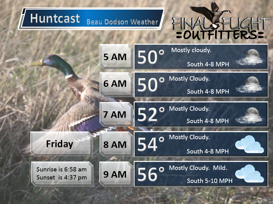
Thursday night – Partly cloudy to mostly cloudy, at times. Mild. Patchy fog/drizzle possible
Temperatures: Lows in the upper 40s. Some locations will remain in the lower 50s.
Winds: South and southwest winds at 5-10 mph. Gusts to 15 mph.
What is the chance for precipitation? 10% for light rain or drizzle.
Coverage of precipitation? Patchy
My confidence in this part of the forecast verifying is High
Should I be concerned about snow or ice? No
Should I cancel my outdoor plans? No
Is severe weather expected? No
What impact is expected? Fog may reduce visibility in some locations. Patchy wet roadways.
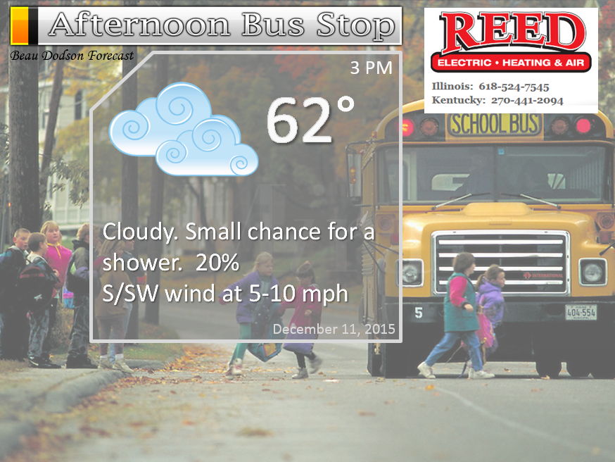
Friday – Some morning fog possible. Patchy drizzle. Quite a few clouds. A 20% chance for a shower.
Temperatures: Highs in the middle to upper 60s
Winds: South winds at 6-12 mph
What is the chance for precipitation? 20%
Coverage of precipitation? Isolated
My confidence in this part of the forecast verifying is High
Should I be concerned about snow or ice? No
Should I cancel my outdoor plans? No
Is severe weather expected? No
What impact is expected? None
Friday night – Cloudy. A chance for an isolated shower.
Temperatures: Lows in the upper 50s
Winds: South at 6-12 mph with gusts to 18 mph
What is the chance for precipitation? 20%
Coverage of precipitation? Isolated
My confidence in this part of the forecast verifying is Medium
Should I be concerned about snow or ice? No
Should I cancel my outdoor plans? No
Is severe weather expected? No
What impact is expected? None
Saturday – Quite a few clouds. Very mild with new record high temperatures. A chance for a shower. Maybe a thunderstorm (low confidence on thunderstorm chances)
Temperatures: Highs in the upper 60s to lower 70s
Winds: Southeast winds at 10-20 mph. Gusty winds.
What is the chance for precipitation? 30%
Coverage of precipitation? Scattered
My confidence in this part of the forecast verifying is High
Should I be concerned about snow or ice? No
Should I cancel my outdoor plans? No
Is severe weather expected? No
What impact is expected? Wet roadways.
Saturday night – Cloudy. A chance for showers and perhaps a rumble of thunder.
Temperatures: Lows in the 58 to 62 degree range
Winds: South and southeast winds at 10-20 mph. Gusty winds at times.
What is the chance for precipitation? 20% east and 40%-50% west.
Coverage of precipitation? Scattered early and then becoming more widespread late
My confidence in this part of the forecast verifying is Medium
Should I be concerned about snow or ice? No
Should I cancel my outdoor plans? Monitor updates
Is severe weather expected? Monitor updates
What impact is expected? Wet roadways. Windy at times.
Sunday – Cloudy. Showers likely. A rumble of thunder possible. Locally heavy rain and gusty winds.
Temperatures: Highs in the middle to upper 60s ahead of the front.
Winds: South/southeast winds at 10-20 mph with gusts to 30+ mph. Winds becoming more south/southwest late.
What is the chance for precipitation? 80%-90%
Coverage of precipitation? Widespread as the day wears on.
My confidence in this part of the forecast verifying is High
Should I be concerned about snow or ice? No
Should I cancel my outdoor plans? Have a plan B.
Is severe weather expected? Low risk.
What impact is expected? Wet roadways. Thunderstorms can’t be ruled out. Heavy rain possible. Strong and gusty winds.
Sunday night – Cloudy. Windy. Showers likely. A rumble of thunder possible.
Temperatures: Lows in the upper 40s (perhaps a bit lower temperatures if the front pushes through quickly)
Winds: South and southwest winds at 10-20 mph with gusts above 30+ mph. Winds may turn around to the west after 3 am on Monday morning.
What is the chance for precipitation? 60%-80%
Coverage of precipitation? Scattered to widespread
My confidence in this part of the forecast verifying is Medium
Should I be concerned about snow or ice? No
Should I cancel my outdoor plans? Possibly. Have a plan B.
Is severe weather expected? Low risk
What impact is expected? Wet roadways. Thunderstorms can’t be ruled out. Strong and gusty winds.
Monday – Cloudy. Perhaps some morning showers. Windy at times. Decreasing clouds possible later in the day.
Temperatures: Highs in the lower 50s. Temperatures might not rise much on Monday
Winds: Southwest/west winds at 10-20 mph with gusts above 20 mph.
What is the chance for precipitation? 40% early in the morning. Decreasing chances as the day wears on.
Coverage of precipitation? Scattered early in the morning
My confidence in this part of the forecast verifying is Medium
Should I be concerned about snow or ice? No
Should I cancel my outdoor plans? No
Is severe weather expected? No
What impact is expected? Wet roadways in the morning.
Monday night – Mostly clear and colder.
Temperatures: Lows in the middle to upper 30s
Winds: West/southwest wind at 8-16 mph
What is the chance for precipitation? 0%
Coverage of precipitation? None
My confidence in this part of the forecast verifying is High
Should I be concerned about snow or ice? No
Should I cancel my outdoor plans? No
Is severe weather expected? No
What impact is expected? None
Tuesday – Mostly sunny.
Temperatures: Highs in the middle 50s
Winds: South/southwest winds at 10-20 mph.
What is the chance for precipitation? 0%
Coverage of precipitation? None
My confidence in this part of the forecast verifying is High
Should I be concerned about snow or ice? No
Should I cancel my outdoor plans? No
Is severe weather expected? No
What impact is expected? None
Tuesday night – Some clouds possible.
Temperatures: Lows in the upper 30s to lower 40s.
Winds: West/southwest wind at 10 mph
What is the chance for precipitation? 10%
Coverage of precipitation? None
My confidence in this part of the forecast verifying is High
Should I be concerned about snow or ice? No
Should I cancel my outdoor plans? No
Is severe weather expected? No
What impact is expected? None
Wednesday – Some clouds. A chance for a shower.
Temperatures: Highs in the lower 40s
Winds: West/northwest winds at 6-12 mph.
What is the chance for precipitation? 20%
Coverage of precipitation? Isolated. Low confidence this far out.
My confidence in this part of the forecast verifying is Low
Should I be concerned about snow or ice? No
Should I cancel my outdoor plans? No
Is severe weather expected? No
What impact is expected? Wet roadways perhaps
Wednesday night – Some clouds. Small chance for precipitation.
Temperatures: Lows in the middle 30s
Winds: Northwest wind at 10 mph
What is the chance for precipitation? 20%
Coverage of precipitation? Isolated
My confidence in this part of the forecast verifying is Low
Should I be concerned about snow or ice? Unlikely
Should I cancel my outdoor plans? No
Is severe weather expected? No
What impact is expected? None
Thursday – Cloudy. A 20% chance for light precipitation.
Temperatures: Highs in the upper 30s to lower 40s
Winds: Northeast winds at 5-10 mph.
What is the chance for precipitation? 20%
Coverage of precipitation? Spotty
My confidence in this part of the forecast verifying is Low
Should I be concerned about snow or ice? Unlikely
Should I cancel my outdoor plans? No
Is severe weather expected? No
What impact is expected? Wet roadways possible if precipitation does occur. Low confidence.

Click their ad below to visit their web-site or click here reedelec.com


Don’t forget to check out the Southern Illinois Weather Observatory web-site for weather maps, tower cams, scanner feeds, radars, and much more! Click here

An explanation of what is happening in the atmosphere over the coming days…
Highlights
1. An unsettled pattern is developing
2. Potential for quite a bit of rain on Saturday night into Sunday evening
3. Strong/high winds likely Sunday and Sunday night/Monday morning.
4. Colder air next week?
Well, our nice streak of weather could not last forever. It is December, after all. A strong late fall storm system will push into the Missouri and Ohio Valleys on Saturday and Sunday. This system will pull plenty of Gulf of Mexico moisture northward over the coming days.
Clouds will be on the increase Thursday night and Friday. A few showers may dot radar from time to time on Friday into Saturday afternoon. But, the bulk of the precipitation is forecast to hold off until Saturday night into Sunday evening. Everything is coming together as anticipated.
Some locally heavy rain and gusty winds are a good bet with this system. I am thinking wind gusts on Sunday into Monday morning will range from 20-40 mph. There will be a peak time of wind gusts near the front. That is when the higher readings are possible. Obviously not good for holiday decorations.
This peak time for wind gusts should be on Sunday into Sunday night.
Rainfall totals of 1.5-2.5″ are likely over southeast Missouri and 1″-2″ elsewhere. I do not anticipated flooding problems with this particular system.
A few of the showers and storms could produce strong winds. Winds aloft will be quite strong late Saturday night into Sunday. But, CAPE values are minimal. CAPE is a measure of instability in the atmosphere. Higher CAPE values equal better potential for severe storms.
The overall severe weather risk with this system is minimal.
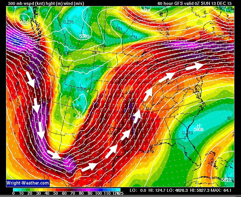
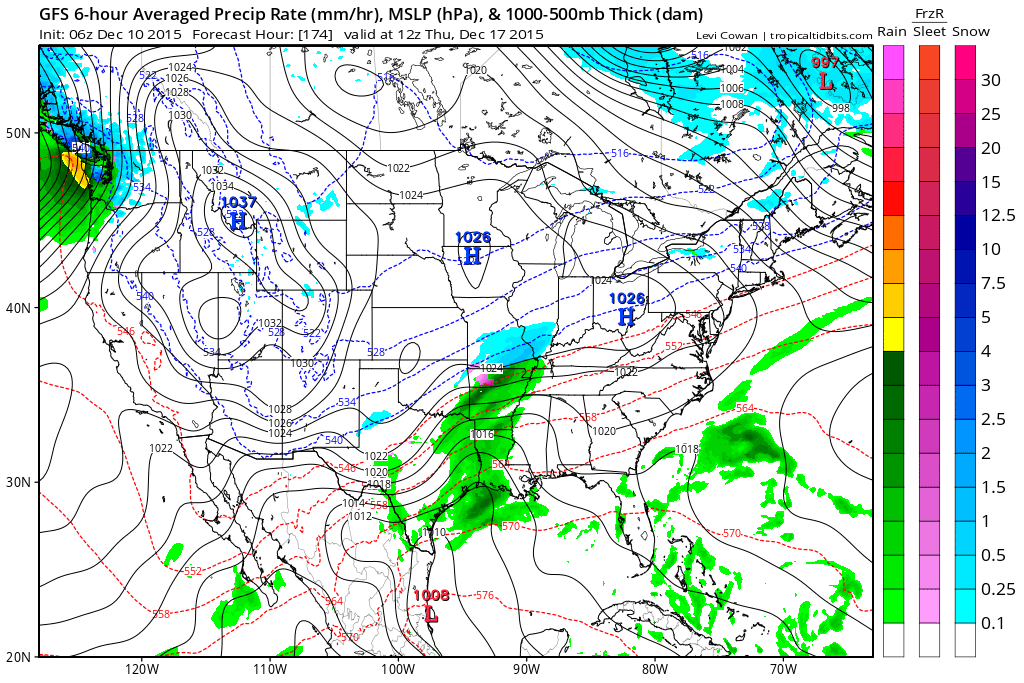
Look at the 500 mb wind map. See the jet stream dipping into the southwest United States and then riding into our region? Lot of moisture being pulled northward with this particular system. If this was later in January or February then we might be dealing with an ice storm. Let’s hope the pattern doesn’t repeat as we move later into winter.
Cooler air will filter in behind the system on Sunday night and Monday. But, nothing extreme.
Guidance is pointing towards a colder blast of air as we push into the middle and end of next week. And, some of the guidance even shows a little bit of snow. The problem with that guidance is there isn’t a lot of agreement with other data sets. However, that does not mean it will be wrong. There is some ensemble support for additional precipitation towards the middle and end of next week. And, if colder air is indeed in place then we will have to monitor trends. Right now it is on the “let’s keep an eye on it” board.
Let’s look at some maps.
First let me show you the NAM model guidance.
These maps are from weatherbell.com They will show you the precipitation anticipated and the timing.
This first map shows you some gray in our region. That color indicates light showers. Bottom line for Friday into Saturday (DAY) is that some light rain is possible. Light and scattered showers. Just enough perhaps to be a nuisance.
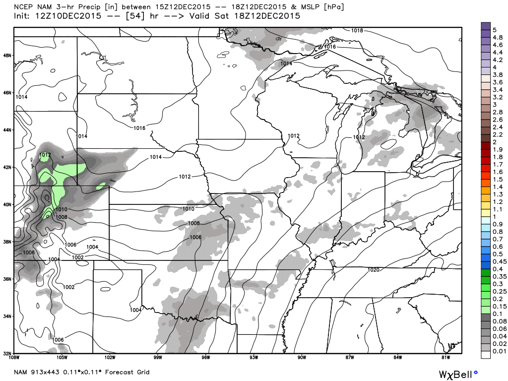
This next map is for Saturday night (late). This is around 11 pm to 1 am. You can see rain moving into our region from the southwest and west. The rain is moving east/northeast. The colors represent three hour rainfall totals.
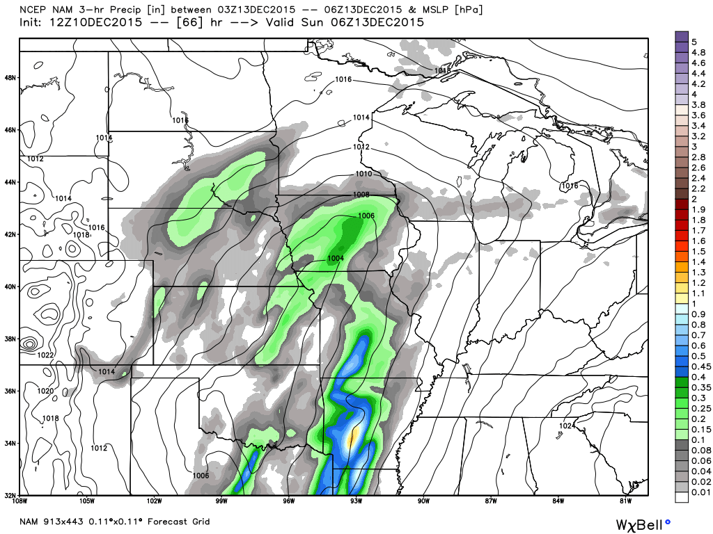
This next map shows you the 12 pm through 3 pm time frame on Sunday afternoon. Expect quite a bit of rain in our region on Sunday.
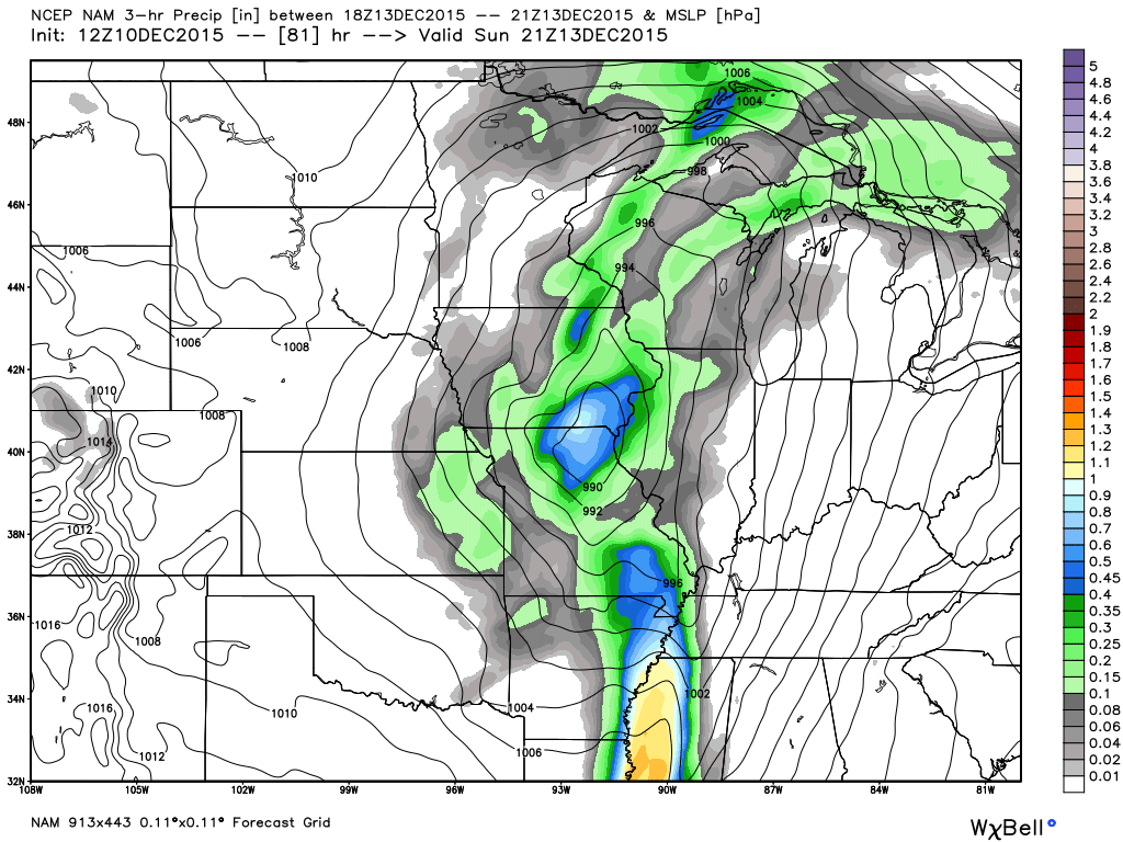
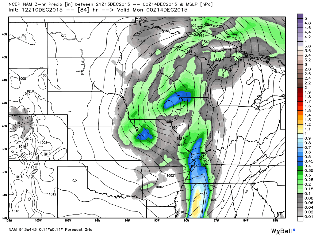
This next map is for Sunday evening.
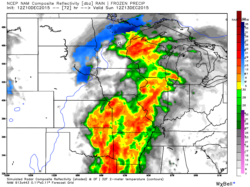
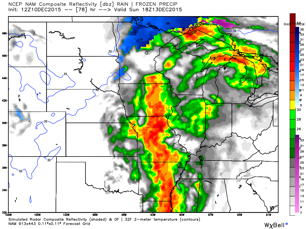
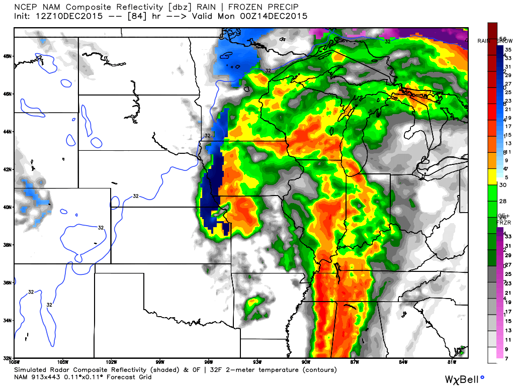
Let’s look at the future-cast radar from the NAM model guidance. Don’t get too caught up in the bright colors. This color scale bar is skewed towards bright colors. Does not mean severe.
This first image is for Sunday morning around 6 am. You can see showers and perhaps some thunderstorms in our region. Again, Sunday should be a wet day for many areas.
This next image is for Sunday around 11 am to 12 pm. Again, quite a bit of rain in the region. Especially the western half of the area. The rain will push east during the day.
This next image is for the 2 pm to 4 pm time frame on Sunday. Quite a bit of rain in our region.
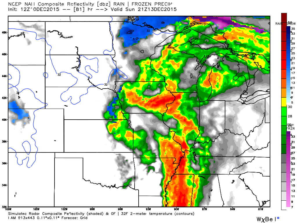
This image is for the evening hours on Sunday. Rain continues in our region. Rain will exit late Sunday night into Monday morning. Most of Monday should be rain free. Perhaps a few remaining morning showers.
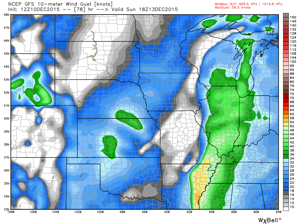
Let me show you the GFS wind map for Sunday late morning and early afternoon. Some gusty winds possible in our area on Sunday. Some of the wind gusts could exceed 40 mph. These colors represent knots.
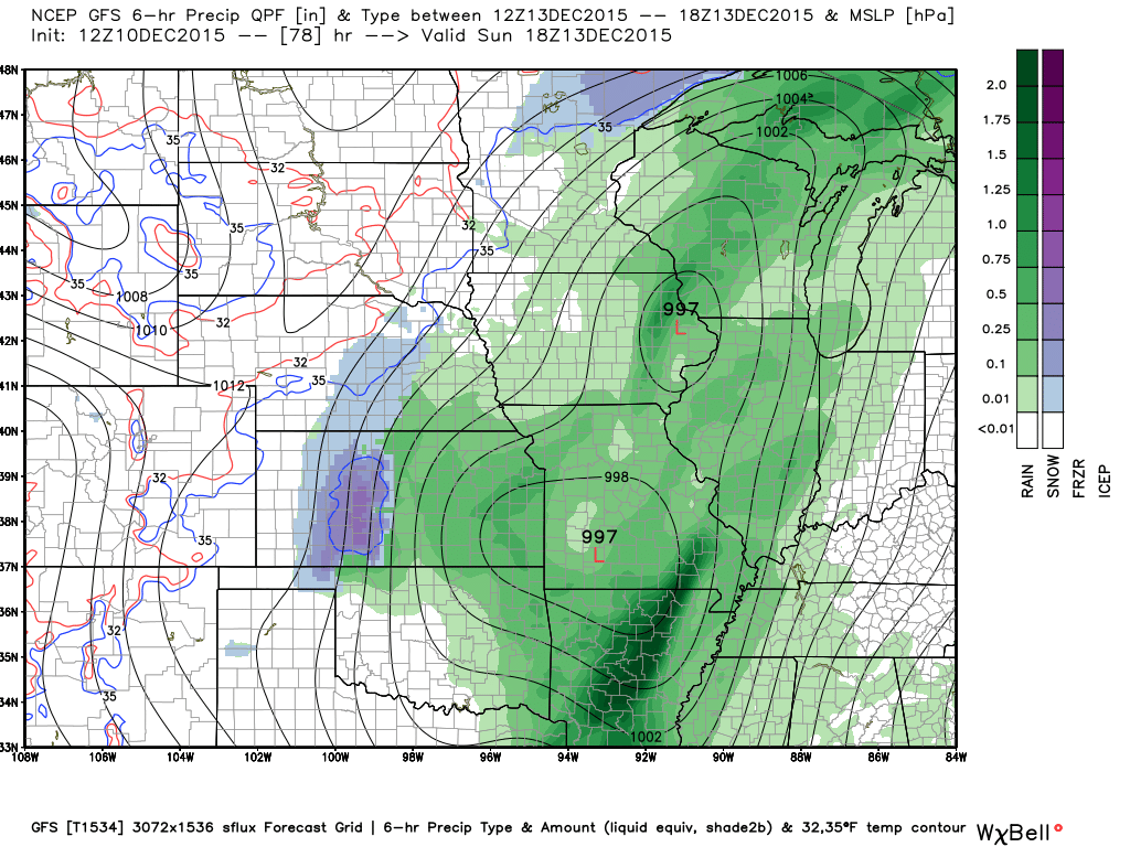
Let me show you the GFS model guidance. The above was the NAM model guidance. Each model guidance can be a little bit different.
The GFS has quite a bit of rain in our region early Sunday morning. But, the look is fairly similar to the NAM. You can see the area of low pressure over northern Missouri. Another low over northwest Oklahoma. These lows are moving northeast and will deepen as to move towards the Great Lakes.
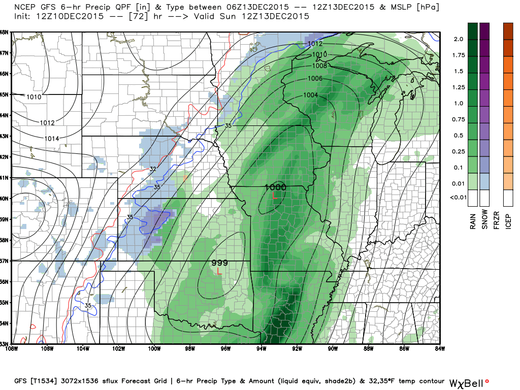
This next map is for Sunday late morning and early afternoon. You can see one low over eastern Iowa. 997 millibars. And, another low over southwest Missouri. This will help pump copious amounts of moisture into our region.
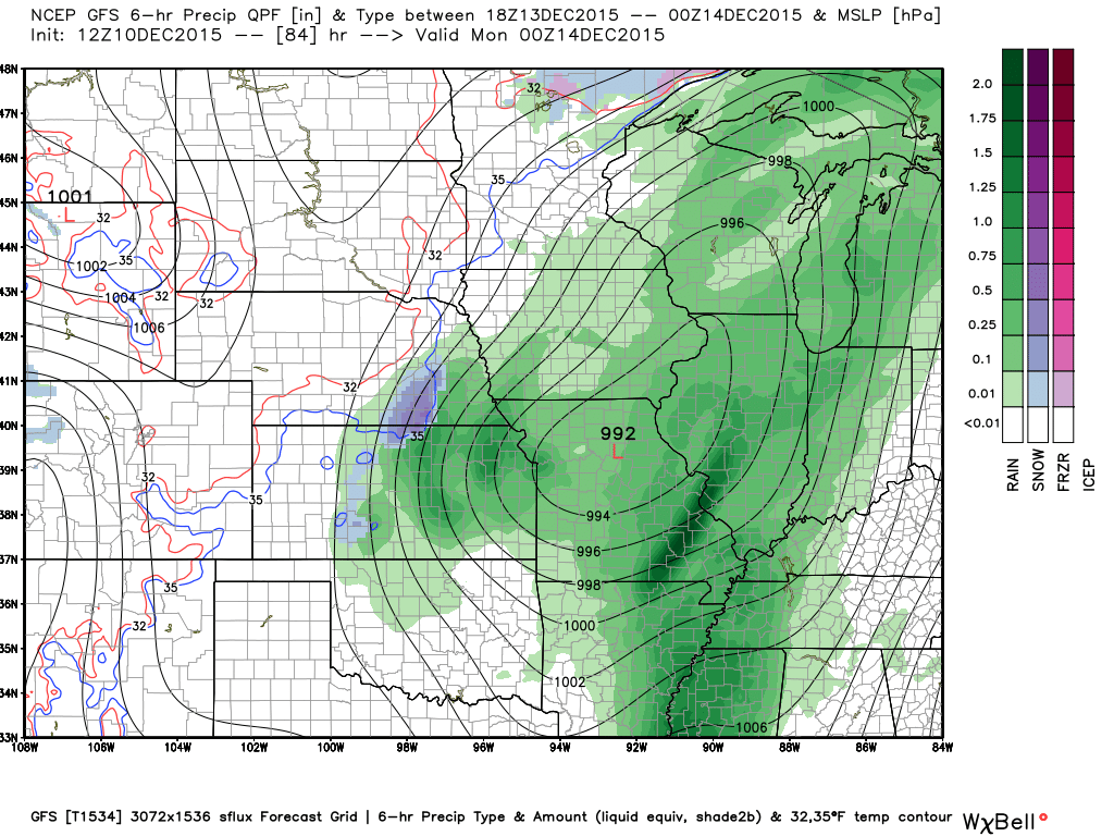
This next GFS model guidance map is for Sunday evening. You can see rain continuing over our region. The main low pressure center is now taking shape over Missouri and moving northeast.
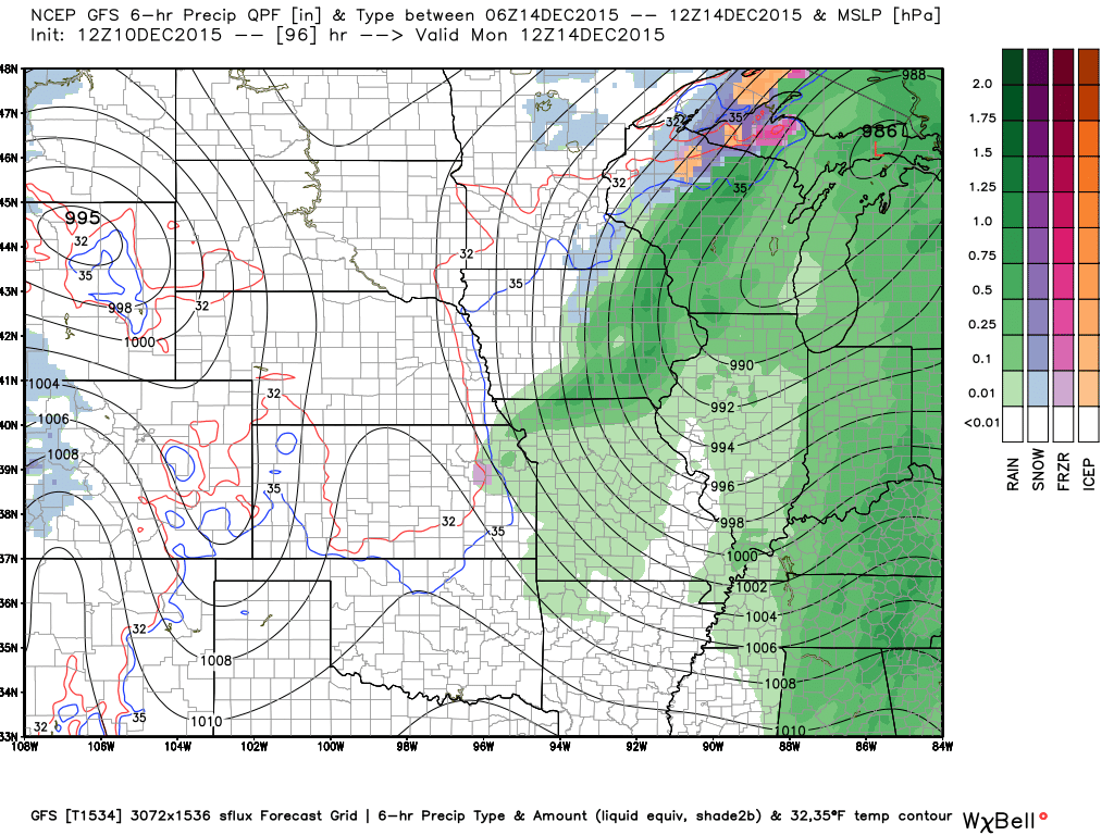
And, finally. This next map is for Monday morning. Precipitation winding down over our region. Moving off to the northeast. Deep area of low pressure north of Michigan. Those lines over our region are isobars. Equal lines of pressure. Tight pressure gradient will mean gusty winds.
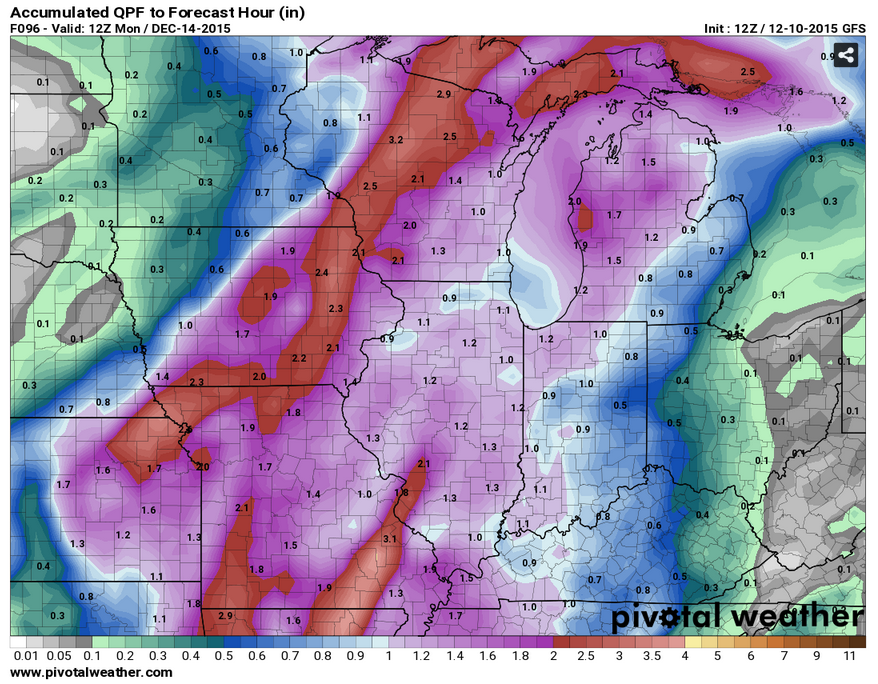
Here is the GFS rainfall total map. You can see the WPC rainfall total map further down in the blog.
Click image for a larger view.
There are a couple of other systems to monitor. The GFS shows some light precipitation in our region on Thursday. I will keep an eye on it.

No snow anticipated.

Friday – No snow or ice anticipated.
Saturday – No snow or ice anticipated.
Sunday – No snow or ice anticipated.
Monday – No snow or ice anticipated.
Tuesday – No snow or ice anticipated.
Wednesday – No snow or ice anticipated.

Updated both temperature and precipitation outlooks.

Watching thunderstorm chances for Saturday night and Sunday. Some locally heavy rain and gusty winds.

Not through Friday. Small chance for a few showers on Friday.
Umbrellas will likely be needed on Saturday night into Sunday night. The later we go into Saturday night the better odds of rain and possibly some storms.
Very gusty winds are likely on Sunday into Sunday night/Monday morning. Wind gusts above 40 mph possible.

The wild card in this forecast will be wind speeds on Sunday into Monday morning. Gusts above 40 mph will be possible as a strong area of low pressure passes through our region and off to the north. The pressure gradient around this system combined with strong winds aloft could spell some gusty winds for Christmas and holiday decorations.

No significant frost or freeze in the current forecast.

How much precipitation should we expect over the next few days?
A few showers will be possible on Friday into Saturday (DAY). Right now those showers are expected to be light. less than 0.10″ of rainfall.
A heavier rain event is unfolding for Saturday night into Sunday night. The main rain shield will likely move over our region late Saturday night and on Sunday. The system may last into Sunday night. This will need to be monitored.
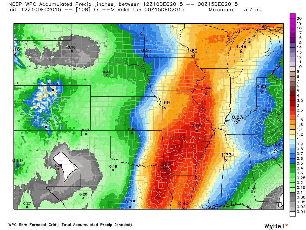
One to two inches of rain appears possible with this system. Heaviest amounts are expected over our western counties.
Here is the latest official rainfall forecast from the WPC. Click image from weatherbell.com to enlarge

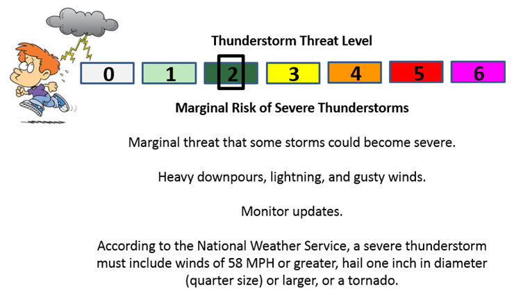
Can we expect severe thunderstorms over the next 24 to 48 hours? Remember that a severe thunderstorm is defined as a thunderstorm that produces 58 mph winds or higher, quarter size hail or larger, and/or a tornado.
The thunderstorm threat level will be ZERO for Friday and a TWO for Saturday night into Sunday evening. Some gusty winds possible with showers and storms.
.
Friday: Severe weather is not anticipated.
Saturday: Severe weather is not anticipated. Saturday night: A few storms possible. Gusty winds.
Sunday: Some thunderstorms are possible. Gusty winds.
Monday: Some storms late Sunday night still possible into early Monday morning. But, should be winding down. Gusty winds.
Tuesday: Severe weather is not anticipated.
Wednesday: Severe weather is not anticipated.
Thursday: Severe weather is not anticipated.

We have regional radars and local city radars – if a radar does not seem to be updating then try another one. Occasional browsers need their cache cleared. You may also try restarting your browser. That usually fixes the problem. Occasionally we do have a radar go down. That is why I have duplicates. Thus, if one fails then try another one.
If you have any problems then please send me an email beaudodson@usawx.com
WEATHER RADAR PAGE – Click here —
We also have a new national interactive radar – you can view that radar by clicking here.
Local interactive city radars include St Louis, Mt Vernon, Evansville, Poplar Bluff, Cape Girardeau, Marion, Paducah, Hopkinsville, Memphis, Nashville, Dyersburg, and all of eastern Kentucky – these are interactive radars. Local city radars – click here
NOTE: Occasionally you will see ground clutter on the radar (these are false echoes). Normally they show up close to the radar sites – including Paducah.


Live Lightning Data – zoom and pan: Click here
Live Lightning Data with sound (click the sound button on the left side of the page): Click here

I also set up a storm tracking page with additional links (use during active weather for quick reference)
Storm Tracking Tool Page
For watches and warnings click the image below. Then, zoom into your local area.


Here is the official 6-10 day and 8-14 day temperature and precipitation outlook. Check the date stamp at the top of each image (so you understand the time frame).
The forecast maps below are issued by the Weather Prediction Center (NOAA).


The latest 8-14 day temperature and precipitation outlook. Note the dates are at the top of the image. These maps DO NOT tell you how high or low temperatures or precipitation will be. They simply give you the probability as to whether temperatures or precipitation will be above or below normal.


Here are the current river stage forecasts. You can click your state and then the dot for your location. It will bring up the full forecast and hydrograph.
Click Here For River Stage Forecasts…

Who do you trust for your weather information and who holds them accountable?
I have studied weather in our region since the late 1970’s. I have 37 years of experience in observing our regions weather patterns. My degree is in Broadcast Meteorology from Mississippi State University and an Associate of Science (AS). I am currently working on my Bachelor’s Degree in Geoscience.
My resume includes:
Member of the American Meteorological Society.
NOAA Weather-Ready Nation Ambassador.
Meteorologist for McCracken County Emergency Management. I served from 2005 through 2015.
I own and operate the Southern Illinois Weather Observatory.
Recipient of the Mark Trail Award, WPSD Six Who Make A Difference Award, Kentucky Colonel, and the Caesar J. Fiamma” Award from the American Red Cross.
In 2009 I was presented with the Kentucky Office of Highway Safety Award.
Recognized by the Kentucky House of Representatives for my service to the State of Kentucky leading up to several winter storms and severe weather outbreaks.
I am also President of the Shadow Angel Foundation which serves portions of western Kentucky and southern Illinois.
There is a lot of noise on the internet. A lot of weather maps are posted without explanation. Over time you should learn who to trust for your weather information.
My forecast philosophy is simple and straight forward.
- Communicate in simple terms
- To be as accurate as possible within a reasonable time frame before an event
- Interact with you on Twitter, Facebook, and the blog
- Minimize the “hype” that you might see on television or through other weather sources
- Push you towards utilizing wall-to-wall LOCAL TV coverage during severe weather events
I am a recipient of the Mark Trail Award, WPSD Six Who Make A Difference Award, Kentucky Colonel, and the Caesar J. Fiamma” Award from the American Red Cross. In 2009 I was presented with the Kentucky Office of Highway Safety Award. I was recognized by the Kentucky House of Representatives for my service to the State of Kentucky leading up to several winter storms and severe weather outbreaks.
If you click on the image below you can read the Kentucky House of Representatives Resolution.

Many of my graphics are from www.weatherbell.com – a great resource for weather data, model data, and more


You can sign up for my AWARE email by clicking here I typically send out AWARE emails before severe weather, winter storms, or other active weather situations. I do not email watches or warnings. The emails are a basic “heads up” concerning incoming weather conditions.