We have some great sponsors for the Weather Talk Blog. Please let our sponsors know that you appreciate their support for the Weather Talk Blog.
Milner and Orr Funeral Home and Cremation Services located in Paducah, Kentucky and three other western Kentucky towns – at Milner and Orr they believe in families helping families. You can find Milner and Orr on Facebook, as well.
![]()
.

For all of your families eye care needs. Visit their web-site here. Or, you can also visit their Facebook page.
.

Best at Enabling Body Shop Profitability since 1996. Located In Paducah Kentucky and Evansville Indiana; serving all customers in between. They provide Customer Service, along with all the tools necessary for body shops to remain educated and competitive. Click the logo above for their main web-site. You can find McClintock Preferred Finishes on Facebook, as well

Expressway Carwash and Express Lube are a locally owned and operated full service Carwash and Lube established in 1987. They have been proudly serving the community for 29 years now at their Park Avenue location and 20 years at their Southside location. They have been lucky enough to partner with Sidecar Deli in 2015, which allows them to provide their customers with not only quality service, but quality food as well. . If you haven’t already, be sure to make Expressway your one stop shop, with their carwash, lube and deli. For hours of operation and pricing visit www.expresswashlube.com or Expressway Carwash on Facebook.

TORNADO SHELTERS! Endrizzi’s Storm Shelters – For more information click here. Endrizzi Contracting and Landscaping can be found on Facebook, as well – click here
I have launched the new weather texting service! I could use your help. Be sure and sign up and fully support all of the weather data you see each day.
This is a monthly subscription service. Supporting this helps support everything else. The cost is $3 a month for one phone, $5 a month for three phones, and $10 a month for seven phones.
For more information visit BeauDodsonWeather.com
Or directly sign up at Weathertalk.com


This forecast update covers far southern Illinois, far southeast Missouri, and far western Kentucky. See the coverage map on the right side of the blog.
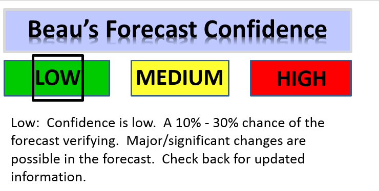
What do the confidence levels mean?


.
This forecast covers the counties in red.

This forecast covers the counties in red.
.
New! Video page on the main Weather Talk web-site.
I am posting videos each day on the WeatherTalk website. The videos can be found under the BeauCast tab. Click here.
.
August 8, 2016
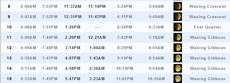
Sunset will be at 7:53 p.m.
Moonrise will be at 11:37 a.m. and moonset will be at 11:14 p.m. Waxing Crescent
Monday Night – Partly cloudy. A small chance for showers over the Pennyrile area of western Kentucky. A small chance for a shower over towards Poplar Bluff. Otherwise, dry.
What impact is expected? Maybe an isolated storm over western parts of southeast Missouri.
Temperatures: Lows in the 68-72 degree range
Winds: Winds northeast and east at 3-6 mph.
What is the chance for precipitation? 20%
Coverage of precipitation: Isolated
Is severe weather expected? No
My confidence in this part of the forecast verifying: High
Should I cancel my outdoor plans? No
.
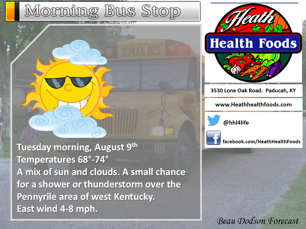
August 9, 2016
Tuesday – Partly to mostly sunny. Warm and humid. Scattered showers and thunderstorm possible (east and southeastern part of the area). Coverage of storms might increase a bit over western Kentucky and Tennessee. That would be in response to a tropical system approaching the Tennessee Valley from the Gulf Coast. Mostly east of LBL. Another chance for thunderstorms near Poplar Bluff and the Ozarks of Missouri.
What impact is expected? Slow moving storms, during the summer months, can produce flash flooding.
Temperatures: High temperatures in the 85-90 degree range.
Winds: East winds at 5-10 mph.
What is the chance for precipitation? 40% monitor updates.
Coverage of precipitation? Perhaps scattered over our far eastern counties (LBL towards Owensboro). Perhaps scattered over our far western counties in southeast Missouri.
Is severe weather expected? Unlikely
My confidence in this part of the forecast verifying: High
Should I cancel my outdoor plans? No, but monitor radars.
Sunrise will be at 6:07 a.m. and sunset will be at 7:52 p.m.
UV index will be 8-11. Most likely high to very high. We will need to monitor cloud cover and any storms in the region.
Moonrise will be at 12:31 p.m. and moonset will be at 11:47 p.m. Waxing Crescent
Tuesday Night – Partly cloudy. A shower or thunderstorm possible over western Kentucky and western Tennessee.
What impact is expected? Slow moving storms, during the summer months, can produce flash flooding.
Temperatures: Lows in the 68-74 degree range
Winds: Winds east at 3-6 mph.
What is the chance for precipitation? 30%
Coverage of precipitation: Scattered
Is severe weather expected? No
My confidence in this part of the forecast verifying: High
Should I cancel my outdoor plans? No, but monitor radars
.
August 10, 2016
Wednesday – Partly cloudy. Warm and humid. Scattered showers and thunderstorms possible.
What impact is expected? Storms could produce heavy rain, strong winds, small hail, and frequent lightning. Slow moving storms, during the summer months, can produce flash flooding.
Temperatures: High temperatures in the 86-92 degree range.
Winds: Southeast and east winds at 4-8 mph.
What is the chance for precipitation? 40%-50% monitor updates.
Coverage of precipitation? Scattered to perhaps numerous
Is severe weather expected? Very small chance for gusty winds with storms
My confidence in this part of the forecast verifying: High
Should I cancel my outdoor plans? No, but monitor radars.
Sunrise will be at 6:08 a.m. and sunset will be at 7:51 p.m.
UV index will be 7-10. Moderate to high. We will need to monitor cloud cover and any storms in the region.
Moonrise will be at 1:26 p.m. and moonset will be at — First quarter
Wednesday Night – Partly cloudy. A shower or thunderstorm possible.
What impact is expected? Storms could produce heavy rain, strong winds, small hail, and frequent lightning. Slow moving storms, during the summer months, can produce flash flooding.
Temperatures: Lows in the 70-74 degree range
Winds: Winds east at 3-6 mph.
What is the chance for precipitation? 40%
Coverage of precipitation: Scattered
Is severe weather expected? Unlikely
My confidence in this part of the forecast verifying: High
Should I cancel my outdoor plans? No, but monitor radars
.
August 11, 2016
Thursday – Partly cloudy. Warm and humid. A chance for scattered thunderstorms.
What impact is expected? Storms could produce heavy rain, strong winds, small hail, and frequent lightning. Slow moving storms, during the summer months, can produce flash flooding.
Temperatures: High temperatures in the 88-94 degree range.
Winds: Southeast winds at 3-6 mph.
What is the chance for precipitation? 40% monitor updates.
Coverage of precipitation? Scattered
Is severe weather expected? Monitor updates
My confidence in this part of the forecast verifying: Medium
Should I cancel my outdoor plans? No, but monitor radars.
Sunrise will be at 6:09 a.m. and sunset will be at 7:49 p.m.
UV index will be 8-11. Most likely high. We will need to monitor cloud cover and any storms in the region.
Moonrise will be at 2:20 p.m. and moonset will be at 12:21 a.m. Waxing Gibbous
Thursday Night – Partly cloudy. A thunderstorm possible.
What impact is expected? Storms could produce heavy rain, strong winds, small hail, and frequent lightning. Slow moving storms, during the summer months, can produce flash flooding.
Temperatures: Lows in the 70-74 degree range
Winds: Winds southwest at 3-6 mph.
What is the chance for precipitation? 30%
Coverage of precipitation: Isolated
Is severe weather expected? Unlikely
My confidence in this part of the forecast verifying: Low
Should I cancel my outdoor plans? No, but monitor radars
.
August 12, 2016
Friday – Partly cloudy. A chance for thunderstorms.
What impact is expected? Storms could produce heavy rain, strong winds, small hail, and frequent lightning. Slow moving storms, during the summer months, can produce flash flooding.
Temperatures: High temperatures in the 88-92 degree range.
Winds: South and southeast winds at 5-10 mph.
What is the chance for precipitation? 40% monitor updates.
Coverage of precipitation? Scattered
Is severe weather expected? Monitor updates
My confidence in this part of the forecast verifying: Medium
Should I cancel my outdoor plans? No, but monitor radars.
Sunrise will be at 6:09 a.m. and sunset will be at 7:48 p.m.
UV index will be 6-8. Moderate to most likely high. We will need to monitor cloud cover and any storms in the region.
Moonrise will be at 3:14 p.m. and moonset will be at 1:00 a.m. Waxing Gibbous
Friday Night – Partly cloudy. A chance for thunderstorms.
What impact is expected? Storms could produce heavy rain, strong winds, small hail, and frequent lightning. Slow moving storms, during the summer months, can produce flash flooding.
Temperatures: Lows in the 72-76 degree range
Winds: Winds south and southeast at 3-6 mph.
What is the chance for precipitation? 40%
Coverage of precipitation: Scattered
Is severe weather expected? Monitor updates
My confidence in this part of the forecast verifying: Medium
Should I cancel my outdoor plans? No, but monitor radars
.
August 13, 2016
Saturday – Partly cloudy. A chance for showers and thunderstorms. Some storms could produce heavy rain.
What impact is expected? Storms could produce heavy rain, strong winds, small hail, and frequent lightning. Slow moving storms, during the summer months, can produce flash flooding.
Temperatures: High temperatures in the 84-88 degree range.
Winds: South and southeast at 5-10 mph.
What is the chance for precipitation? 40% monitor updates.
Coverage of precipitation? Scattered
Is severe weather expected? Monitor updates
My confidence in this part of the forecast verifying: Low
Should I cancel my outdoor plans? No, but monitor radars.
Sunrise will be at 6:10 a.m. and sunset will be at 7:46 p.m.
UV index will be 4-8. Low to moderate. We will need to monitor cloud cover and any storms in the region.
Moonrise will be at 4:07 p.m. and moonset will be at 1:43 a.m. Waxing Gibbous
Saturday Night – Partly cloudy. Thunderstorms possible. Some storms could produce heavy rain.
What impact is expected? Storms could produce heavy rain, strong winds, small hail, and frequent lightning. Slow moving storms, during the summer months, can produce flash flooding.
Temperatures: Lows in the 68-74 degree range
Winds: Winds south at 3-6 mph. Winds becoming variable in direction.
What is the chance for precipitation? 50%
Coverage of precipitation: Scattered to perhaps numerous
Is severe weather expected? Monitor updates
My confidence in this part of the forecast verifying: Medium
Should I cancel my outdoor plans? No, but monitor radars
.
August 14, 2016
Sunday – Partly cloudy. A chance for showers and thunderstorms. Some storms could produce heavy rain.
What impact is expected? Storms could produce heavy rain, strong winds, small hail, and frequent lightning. Slow moving storms, during the summer months, can produce flash flooding.
Temperatures: High temperatures in the 84-88 degree range.
Winds: Variable winds at 5-10 mph.
What is the chance for precipitation? 50% monitor updates.
Coverage of precipitation? Perhaps numerous
Is severe weather expected? Small risk
My confidence in this part of the forecast verifying: Medium
Should I cancel my outdoor plans? No, but monitor radars.
Sunrise will be at 6:11 a.m. and sunset will be at 7:46 p.m.
UV index will be 5-8. Moderate. We will need to monitor cloud cover and any storms in the region.
Moonrise will be at 4:58 p.m. and moonset will be at 2:30 a.m. Waxing Gibbous
Sunday Night – Partly cloudy. A chance for showers and thunderstorms. Some storms could produce heavy rain.
What impact is expected? Storms could produce heavy rain, strong winds, small hail, and frequent lightning. Slow moving storms, during the summer months, can produce flash flooding.
Temperatures: Lows in the 65-70 degree range
Winds: Winds variable at 3-6 mph.
What is the chance for precipitation? 50%
Coverage of precipitation: Scattered
Is severe weather expected? Small risk
My confidence in this part of the forecast verifying: Medium
Should I cancel my outdoor plans? No, but monitor radars
More information on the UV index. Click here.
The School Bus Stop Forecast is sponsored by Heath Health and Wellness. Located next to Crowell Pools in Lone Oak, Kentucky.
Visit their web-site here. And. visit Heath Health Foods on Facebook!

Heath Health Foods is a locally owned and operated retail health and wellness store. Since opening in February 2006; the store has continued to grow as a ministry with an expanding inventory which also offers wellness appointments and services along with educational opportunities. Visit their web-site here. And. visit Heath Health Foods on Facebook!
.
The weekend forecast is sponsored by Farmer and Company Real Estate.

Farmer & Company Real Estate is proud to represent buyers and sellers in both Southern Illinois and Western Kentucky. With 13 licensed brokers, we can provide years of experience to buyers & sellers of homes, land & farms and commercial & investment properties. We look forward to representing YOU! Follow us on Facebook, as well
The weekend forecast is sponsored by Farmer and Company Real Estate. Click here to visit their site.


Don’t forget to check out the Southern Illinois Weather Observatory web-site for weather maps, tower cams, scanner feeds, radars, and much more! Click here

An explanation of what is happening in the atmosphere over the coming days…
- Increasing dew points and humidity
- Increasing shower and thunderstorm chances
- Tropical system
- Cold front this weekend
Tuesday delivered decent weather to most of the region. We had a complex of storms push eastward across Missouri and northern Arkansas. This was responsible for a few shower and thunderstorms over our far western counties in southeast Missouri. Much of the region remained dry with some spotty clouds.
The weather picture will be changing over the coming days. Moisture levels will be on the rise. Dew points will pop back into the uncomfortable 70’s. Temperatures will rise into the upper 80’s and lower 90’s. It will once again feel like summer.
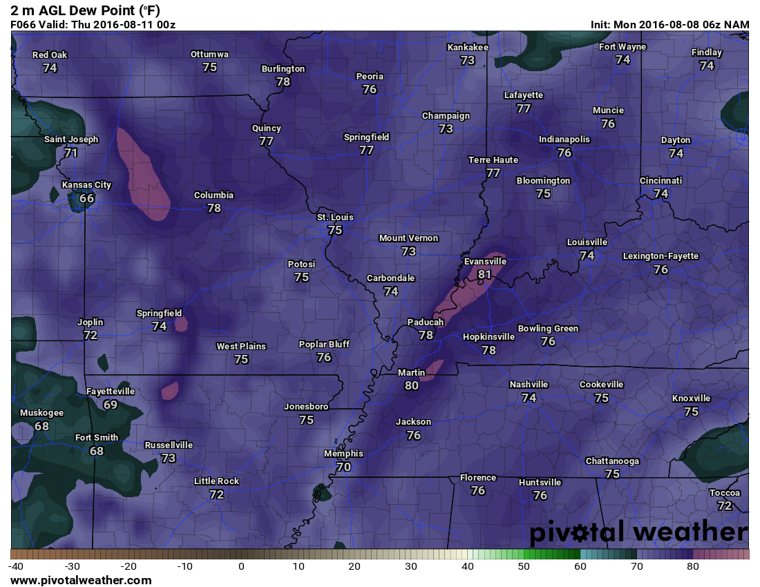
Notice the dew points on WeWednesdaysday. There are even some upper 70’s and lower 80’s showing up. This is the dew point map (not temperatures). Dew points into the 70’s would be air that you wear (as Jim Rasor says).
A tropical disturbance along the Gulf of Mexico will be responsible for an increase in both clouds and shower/thunderstorm chances as we push into Tuesday. The best chances for precipitation on Tuesday and Tuesday night will be the Pennyrile area of western Kentucky. If you were to draw a line from LBL towards Owensboro and then travel east of that line you might run into some precipitation. Lesser chances as you go west of that line. I will introduce shower chances for western Kentucky and Tennessee on Tuesday.
A weak disturbance well to our west could also spell a couple of showers or thunderstorms over southeast Missouri Monday night into Tuesday night.
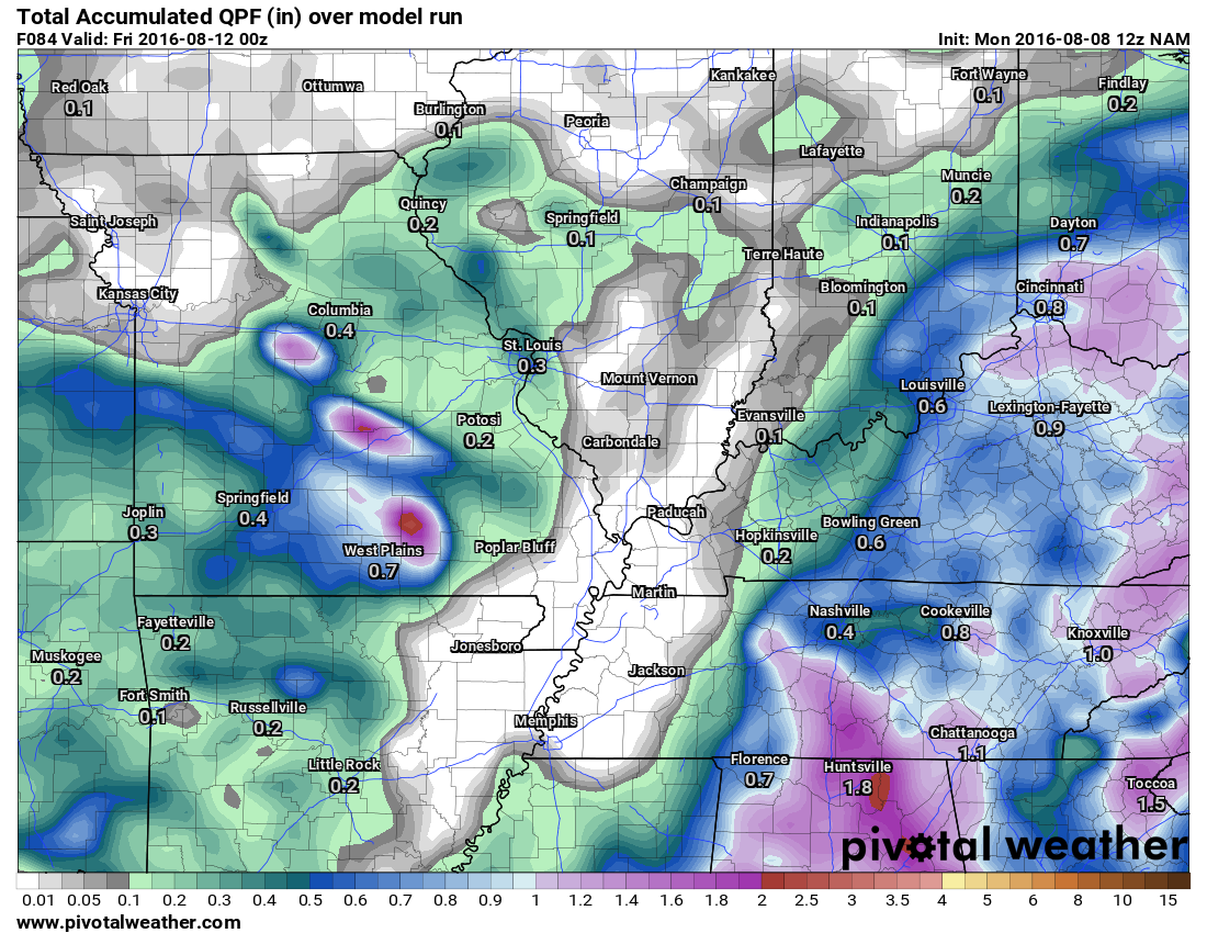
Notice how much of the precipitation stays to the west and the east through Thursday. This might not be exact, but it has the idea. This is the NAM model.
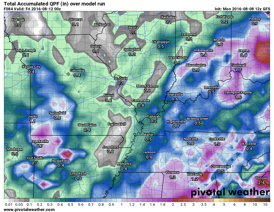
Here is the GFS model. Notice how it covers a bit more of the region with rain between now and Thursday night. Let’s keep an eye on how far west the tropical moisture pushes over the coming days.
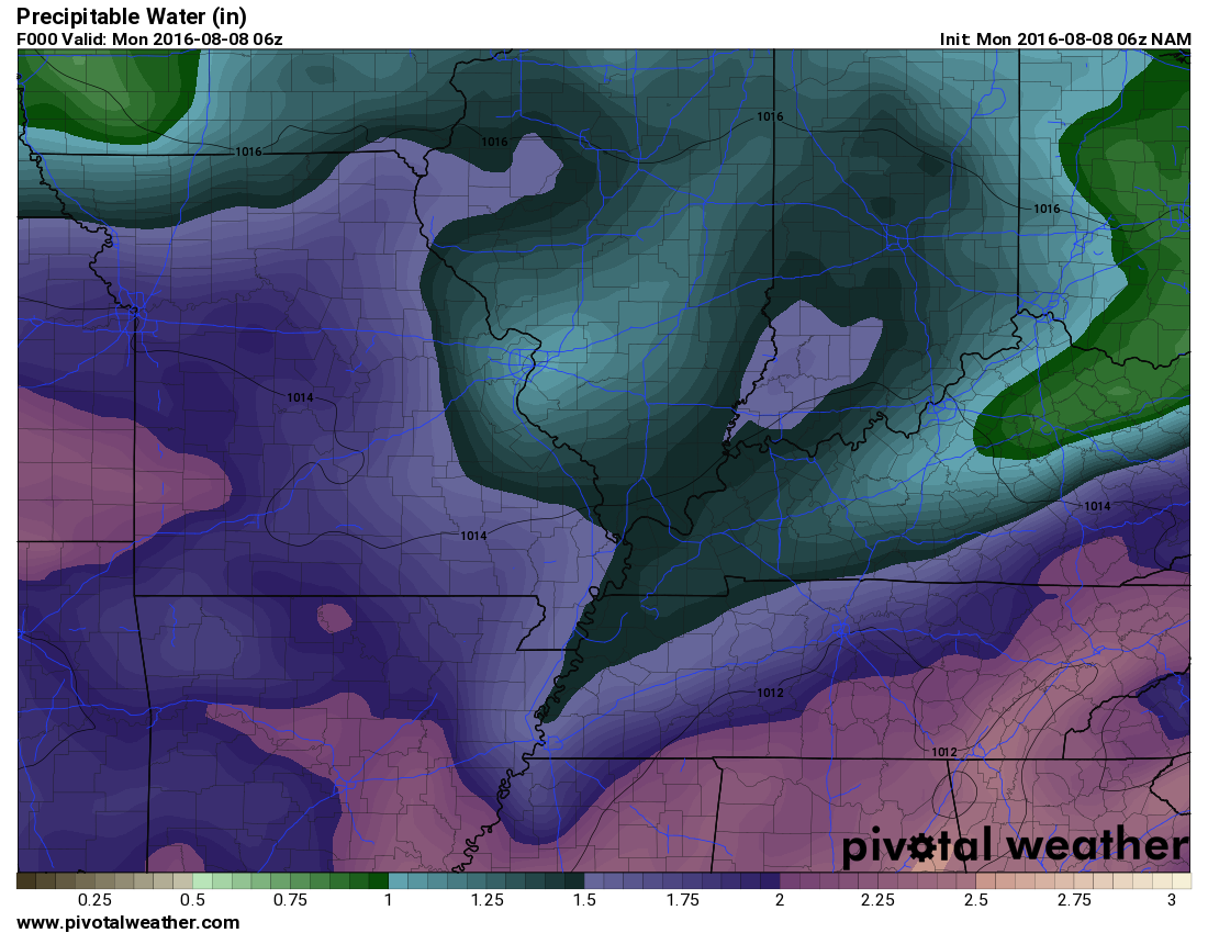
Clouds and precipitation chances will spread north and west with time. On Wednesday the entire area will have at least a chance for a shower or thunderstorm. Locally heavy rain will once again be a concern as PWAT values will be climbing back above two inches. PWAT values are a measure of moisture in the entire atmosphere. Anything about two inches is extreme. That is one reason we have had such a wet summer. High PWAT values.
You can see on this map how PWAT values looked on Monday
Now look at this map for Wednesday night. Notice the jump? Moisture levels will be on the rise. Any storms that form could produce heavy rain.
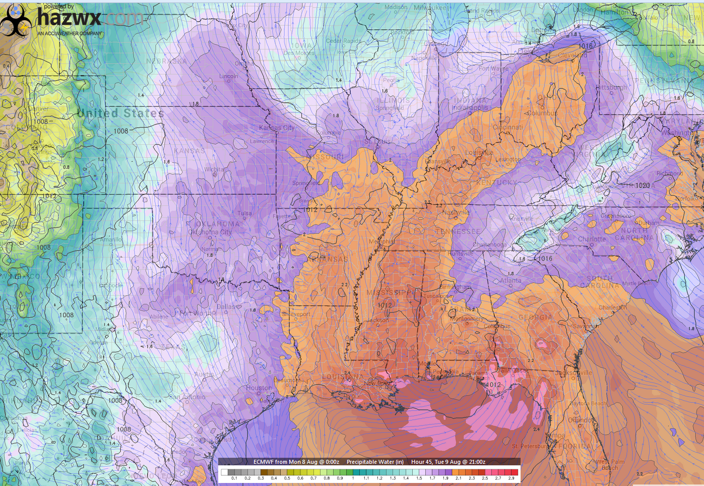
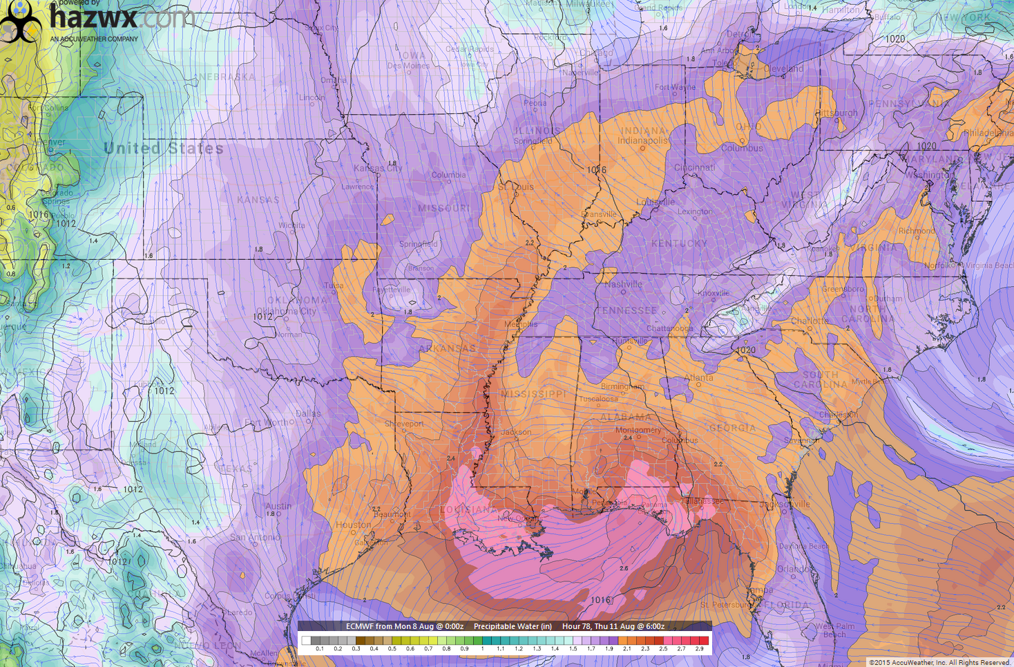
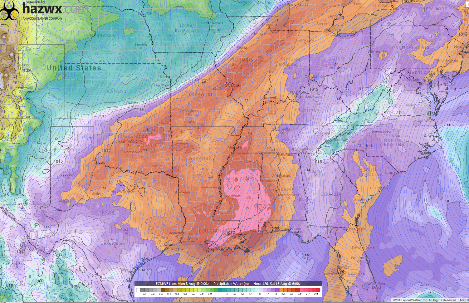
Let me show you the EC guidance. This is showing you the very high PWAT totals later this week. Again, that means potentially heavy rainfall totals.
I am concerned about this. Historically this setup produces very heavy rain.
Click images for a larger view.
The orange and red colors are high PWAT values. See how they come out of the Gulf of Mexico? That is a sign for heavy rain. This first map is for Tuesday.
This next map is for Thursday. Tongue of moisture into the Gulf of Mexico.
This next map is for Saturday. Lot of moisture.
Shower and thunderstorm chances will stick with us into the weekend.
A cold front will approach from the north and west on Friday and Saturday. This front will slowly move through our region over the weekend. Shower and thunderstorm chances will certainly be on the increase along this front. Some of the storms could be quite heavy. Flash flooding will continue to be a concern. It will be impossible to say who receives the heaviest rain totals. These slow moving storms can be random in development.
The front is forecast to push out of our region by Sunday night or Monday. It will be a slow mover. Rain chances may linger over Kentucky and Tennessee into Sunday night or Monday. This is a bit of a wild card and will need to be monitored.
Meteorological fall begins on September 1st. We will stair step down into more frequent cool shots and stronger cold fronts as we enter fall. Fall typical delivers a few severe weather events, as well. We are no stranger to fall severe weather.
I will be on vacation from August 10th through August 19th. I will keep everything updated, but perhaps a little less content.
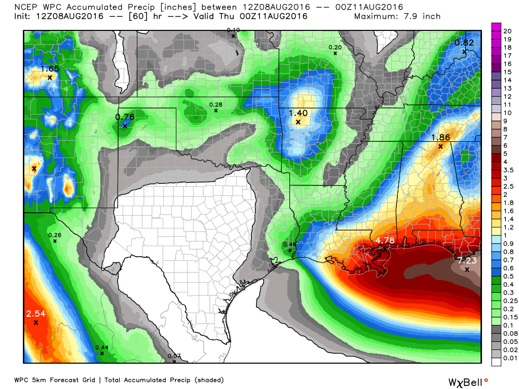
How much rain is forecast over the coming days?
Here are the rain totals through Wednesday afternoon.
We will have to monitor Wednesday. Coverage could be a bit greater than the WPC is showing. This is the WPC/NOAA forecast map.
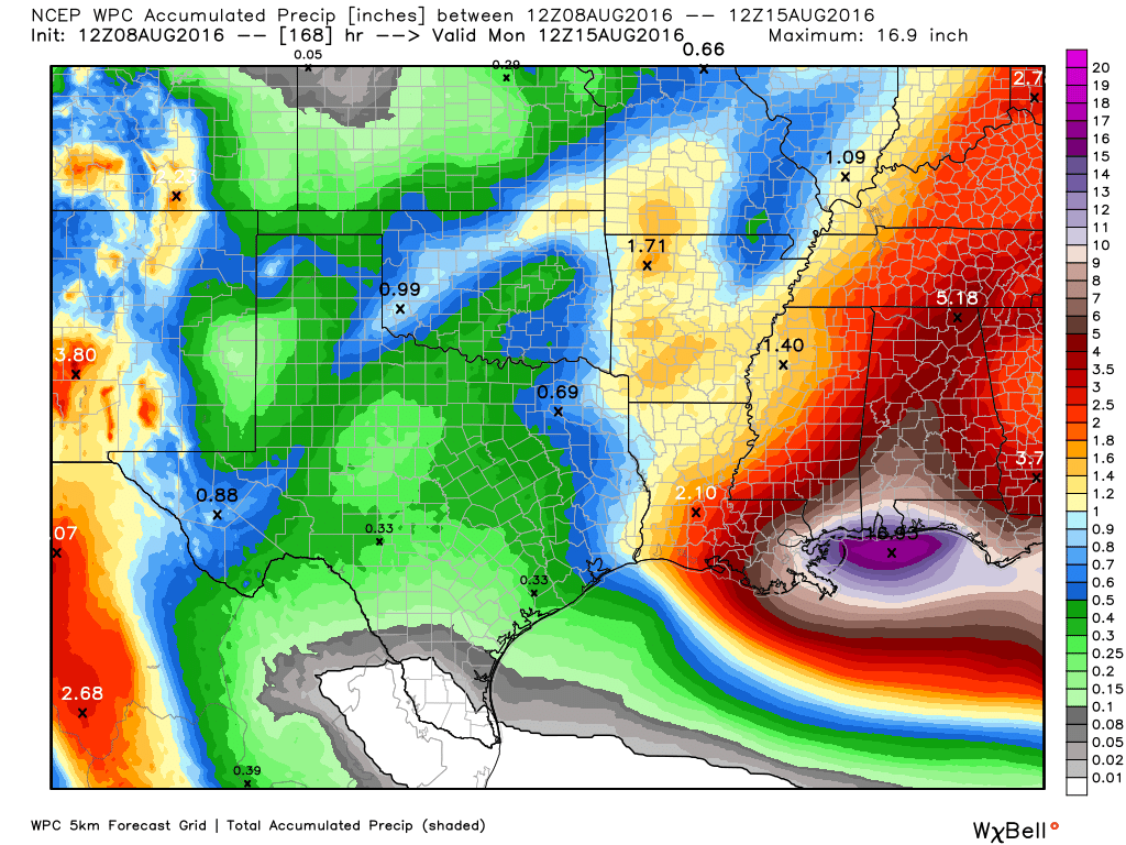
Here are the rain totals from now through next Sunday. Much of this falls on Friday, Saturday, and Sunday as a cold front enters our region.
We could have MUCH heavier totals in spots. Same as recent weeks. This is simply a broad-brushed map.
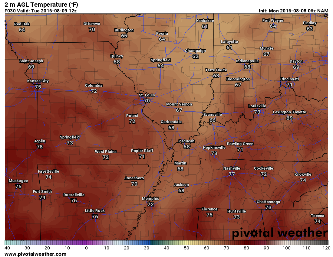
Tuesday morning low temperature map (temperatures over the coming days will vary based on clouds)
Click images for a larger view
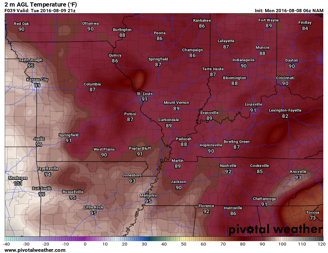
Tuesday high temperature forecast
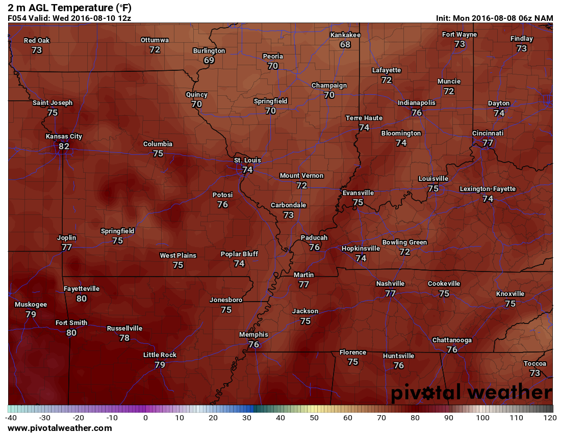
Wednesday morning low temperature map
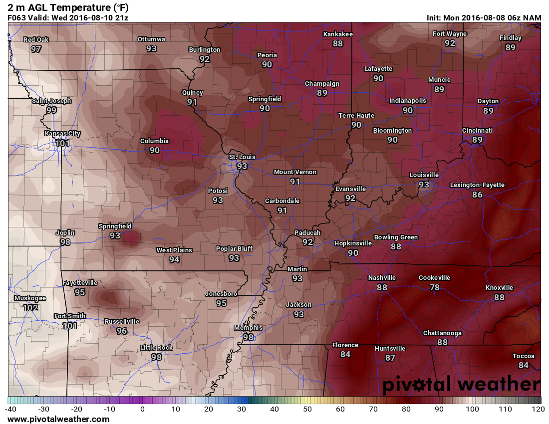
Wednesday afternoon high temperature map (will vary based on clouds and precipitation)
I will keep the Beau Dodson Weather Facebook page updated, Beau Dodson on Twitter, and the texts. Don’t forget if you want to receive links to the daily blog and Facebook updates to check box number four on the texting site. That is the one used for non-severe days.
Storm Tracking Radar


We have regional radars and local city radars – if a radar does not seem to be updating then try another one. Occasional browsers need their cache cleared. You may also try restarting your browser. That usually fixes the problem. Occasionally we do have a radar go down. That is why I have duplicates. Thus, if one fails then try another one.
If you have any problems then please send me an email beaudodson@usawx.com
WEATHER RADAR PAGE – Click here —
We also have a new national interactive radar – you can view that radar by clicking here.
Local interactive city radars include St Louis, Mt Vernon, Evansville, Poplar Bluff, Cape Girardeau, Marion, Paducah, Hopkinsville, Memphis, Nashville, Dyersburg, and all of eastern Kentucky – these are interactive radars. Local city radars – click here

Live Lightning Data – zoom and pan: Click here
Live Lightning Data with sound (click the sound button on the left side of the page): Click here

Can we expect severe thunderstorms over the next 24 to 48 hours? Remember that a severe thunderstorm is defined as a thunderstorm that produces 58 mph winds or higher, quarter size hail or larger, and/or a tornado.
.
Monday night and Tuesday: Severe weather is not anticipated. A few scattered storms are possible.
Tuesday night -Friday: Increasing chances for scattered thunderstorms. A few storms could produce strong winds. Heavy rain is a concern.
.

.
Updated wind direction and rain chances.

.
Slow moving storms this week could cause some flash flooding. Keep that in mind.

.
Monitor radars in case a storm develops. Lightning and heavy rain being the main issues.
.

Here are the current river stage forecasts. You can click your state and then the dot for your location. It will bring up the full forecast and hydrograph.
..

Here is the official 6-10 day and 8-14 day temperature and precipitation outlook. Check the date stamp at the top of each image (so you understand the time frame).
The forecast maps below are issued by the Weather Prediction Center (NOAA).


The latest 8-14 day temperature and precipitation outlook. Note the dates are at the top of the image. These maps DO NOT tell you how high or low temperatures or precipitation will be. They simply give you the probability as to whether temperatures or precipitation will be above or below normal.


Who do you trust for your weather information and who holds them accountable?
I have studied weather in our region since the late 1970’s. I have 37 years of experience in observing our regions weather patterns. My degree is in Broadcast Meteorology from Mississippi State University and an Associate of Science (AS). I am currently working on my Bachelor’s Degree in Geoscience.
My resume includes:
Member of the American Meteorological Society.
NOAA Weather-Ready Nation Ambassador.
Meteorologist for McCracken County Emergency Management. I served from 2005 through 2015.
I own and operate the Southern Illinois Weather Observatory.
Recipient of the Mark Trail Award, WPSD Six Who Make A Difference Award, Kentucky Colonel, and the Caesar J. Fiamma” Award from the American Red Cross.
In 2009 I was presented with the Kentucky Office of Highway Safety Award.
Recognized by the Kentucky House of Representatives for my service to the State of Kentucky leading up to several winter storms and severe weather outbreaks.
I am also President of the Shadow Angel Foundation which serves portions of western Kentucky and southern Illinois.
There is a lot of noise on the internet. A lot of weather maps are posted without explanation. Over time you should learn who to trust for your weather information.
My forecast philosophy is simple and straight forward.
- Communicate in simple terms
- To be as accurate as possible within a reasonable time frame before an event
- Interact with you on Twitter, Facebook, and the blog
- Minimize the “hype” that you might see on television or through other weather sources
- Push you towards utilizing wall-to-wall LOCAL TV coverage during severe weather events
I am a recipient of the Mark Trail Award, WPSD Six Who Make A Difference Award, Kentucky Colonel, and the Caesar J. Fiamma” Award from the American Red Cross. In 2009 I was presented with the Kentucky Office of Highway Safety Award. I was recognized by the Kentucky House of Representatives for my service to the State of Kentucky leading up to several winter storms and severe weather outbreaks.
If you click on the image below you can read the Kentucky House of Representatives Resolution.

Many of my graphics are from www.weatherbell.com – a great resource for weather data, model data, and more


You can sign up for my AWARE email by clicking here I typically send out AWARE emails before severe weather, winter storms, or other active weather situations. I do not email watches or warnings. The emails are a basic “heads up” concerning incoming weather conditions.