
3 PM
Storms are forming and moving into southern Illinois. They are growing in intensity.
Live coverage on Facebook – Click here
Radars are up and running
Radars
WEATHER RADAR PAGE – Click here —

I also set up a storm tracking page with additional links (use during active weather for quick reference)
Storm Tracking Tool Page
1 PM
A tornado watch has been issued for the rest of the afternoon for much of the region
http://www.spc.noaa.gov/products/watch/ww0112.html
12 PM
Areas of interest over the coming hours. This is where I believe storms will develop and move southeast.


Three day ago this was my forecast zone – red box. This is where I still have placed the greatest risk for severe weather. We will see how it unfolds.

11 AM
Today is a Weather Aware Day. That just means we pay a bit more attention to the weather.
Right now I am waiting to see where the clearing line ends up being placed later today. This could be the boundary where storms initiate and become severe.
A lot of questions remain on how this event unfolds. There is low confidence in the outcome. But, if storms form then they could quickly become severe later today.
Visible satellite at 11 am. You can see the clearing back in Missouri and Arkansas. The clearing line is advancing east/northeast. Heating will occur once the sky clears at your location.


You can see the cyclone over northern Missouri and Kansas. It will slide east and then southeast later today. The dry punch is very visible here on the water vapor image. That dry punch is where the clearing line will ride. Heating will occur. This is a classic set-up for severe weather as far as the dry punch and cyclone location.

This is the new day 1 outlook from the Storm Prediction Center – they have shifted the red zone a bit more. The red zone is where severe weather is “most” likely. Other areas in yellow could also experience severe storms and then lesser chances in the other shaded zones.

7 AM
Overnight storms never formed. Most areas remained dry.
The forecast for today continues to indicate some severe storms could form later this morning and then additional storms later this afternoon and evening. It is a wait and see at this point.
The area in red is the greatest risk zone. This could be adjusted as we move through the day. Areas in yellow and orange could also experience some severe storms.

Today into this evening would be a good time to monitor updated forecasts. Some severe storms are possible. Although the actual number of storms should be on the low side…those storms that form could be quite severe.
I will update the blog from time to time. There remain some questions about how today will unfold. Some data shows very little in the way of thunderstorm development. Scattered in nature. Also some of the new data does not develop storms until very late in the afternoon. Needless to say, this does not add confidence to the forecast.
I will have live and continuous coverage on the Beau Dodson Weather Facebook page. It is there that you can interact with me and ask questions. This is the best way that I know of to interact with all of you…the general public. You can ask questions and I can answer them quickly. I also post images on there.
We have some great sponsors for the Weather Talk Blog. Please let our sponsors know that you appreciate their support for the Weather Talk Blog.
Milner and Orr Funeral Home and Cremation Services located in Paducah, Kentucky and three other western Kentucky towns – at Milner and Orr they believe in families helping families. You can find Milner and Orr on Facebook, as well.
![]()

This forecast update covers far southern Illinois, far southeast Missouri, and far western Kentucky. See the coverage map on the right side of the blog.
Remember that weather evolves. Check back frequently for updates, especially during active weather.
The forecast numbers below may vary quite a bit across the region. These are the averages.
Saturday – Today is a Weather Aware Day. That means that we pay a little more attention to the weather than usual. Any morning precipitation will come to an end. Then a chance for a few storms to redevelop later today. I can’t rule out severe thunderstorms (if storms form). High temperatures near 80 degrees south and southwest of the warm front. Cooler northeast of the warm front. Southwest winds developing at 10-25 mph and gusty.
My confidence in this part of the forecast verifying is medium
Should I cancel my outdoor plans? You should have a plan B.
Radars
WEATHER RADAR PAGE – Click here —
I also set up a storm tracking page with additional links (use during active weather for quick reference)
Storm Tracking Tool Page
Saturday night – Thunderstorms ending. A few storms early in the evening could be severe. Turning cooler with northwest winds at 10-15 mph. Lows in the 50’s.
My confidence in this part of the forecast verifying is high
Should I cancel my outdoor plans? After the evening storms end then no further precipitation is expected.
Sunday – A few clouds. Lot of sun. Cooler. Highs only in the upper 50’s to middle 60’s. North/northwest winds at 10-15 mph.
My confidence in this part of the forecast verifying is high
Should I cancel my outdoor plans? No reason to cancel plans on Sunday.
Sunday night – Clearing and cooler. Lows in the 40’s. North winds at 5 mph.
My confidence in this part of the forecast verifying is high
Should I cancel my outdoor plans? No reason to cancel plans.
Monday – Just a few clouds. Otherwise sunny. Highs in the 60’s. Light winds.
My confidence in this part of the forecast verifying is high
Should I cancel my outdoor plans? No.
The latest data indicates that much of this week may end up remaining dry. The large storm system on Monday and Tuesday continues to trend southward. If this continues then we may finally have a dry spell. Much needed dry spell, I might add.
![]()
Sunrise and Sunset Times – Click Here

Current Temperatures Around The Local Area


Don’t forget to check out the Southern Illinois Weather Observatory web-site for weather maps, tower cams, scanner feeds, radars, and much more! Click here

An explanation of what is happening in the atmosphere over the coming days…
Highlights
1. Some storms possible today
2. Storms should end later this evening. Cooler overnight.
3. Dry on Sunday
This is an abbreviated version of WeatherTalk because of the possibility of a severe weather event in our region on Saturday.
All of the data is indicating that morning showers and thunderstorms (what end up forming) will quickly move off to the northeast. We will be situated on the south side of the warm front (most of us). That means clearing sky conditions and warm temperatures. Some places may actually see temperatures rise above 80 degrees.
Winds will turn out of the southwest and become strong and gusty. Expect general winds of 10-25 mph from time to time with gusts above 30 mph.
By late morning the clearing line should have reached well into southern Illinois and western Kentucky. We will watch temperatures rise and with rising temperatures will come rising instability.
By late morning and early afternoon we can expect a very unstable atmosphere in the region.
At this point is where the questions begin. Some of the data holds thunderstorm development off until between 3 pm and 8 pm. Other data develops storms as early as 11 am to 2 pm. Sometimes these events can be all or nothing. Meaning, sometimes these bigger event days can bring very little activity. The CAP does not break. Storms don’t form as expected.
An area of low pressure will move out of northeast Missouri and towards southern Illinois. An area of showers and thunderstorms could form to the south of the area of low pressure and along the warm front that will be draped near our region. These storms will move from the northwest towards the southeast. Other cells could move more east to west. Storms will move at speeds of 40-60 mph. This will give very little time to take shelter if a severe storm were to form.
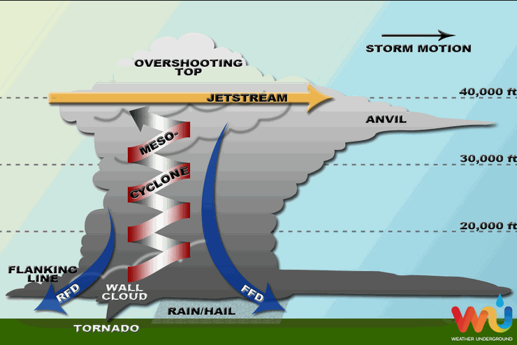
Not everyone will experience storms today. Some places will remain dry. Some of you will have a beautiful day. This is how supercell thunderstorms work. A few cells feed off of all of the energy. That makes them so intense.
What does a supercell thunderstorm look like in a diagram? Here is a side view of a supercell thunderstorm.
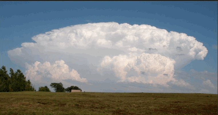
In a photograph it might look like this
and on radar it might look like this

Parameters coming together on Saturday will include a CAP early in the day. You can see that CAP here on this map. Denoted by the purple colors. A CAP will help keep storms from forming early on. What does this do? It allows the atmosphere to energize. Temperatures will rise and CAPE values will rise. The CAP means that there won’t be much in the way of clouds or storms during the mid to late morning hours. But, when the CAP breaks…then storms could explode upwards.
The image below shows you the CAP in purple and red colors. A strong CAP. This is around 10 am tomorrow morning.

Then by around 1 pm. The CAP is gone. That means that any updrafts are free to rise, thus forming thunderstorms.
See how the colors are gone? Black means there is no CAP.

CAPE Values (CAPE is basically energy for the thunderstorms) will be high tomorrow. Expect readings of 2000-3000+ in the region. That will grab your attention.
These are the CAPE numbers for around 1 pm. This is a lot of energy for any storms that form.

Radars
WEATHER RADAR PAGE – Click here —
I also set up a storm tracking page with additional links (use during active weather for quick reference)
Storm Tracking Tool Page
Don’t forget to support our sponsors!

Obvious concerns today will be a few storms becoming severe. Still a lot of questions above coverage. Uncertain about the timing of new development later today.

Yes. Action is required.
Monitor the latest weather radars.
Storms will be moving fast. Storms will move in a couple of directions. Some cells will move from the northwest towards the south/southeast. Other storms will move from west to east at speeds in excess of 40-60 mph. This will give very little time to take shelter.
Monitor warnings closely. If there is a warning to your west then go ahead and prepare to take shelter…soon.
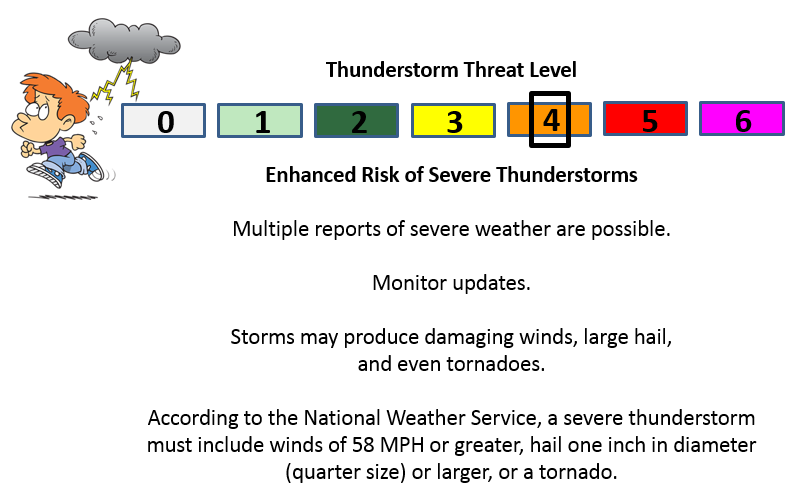
See the severe weather numbers further down in the blog. Today is a FOUR on the scale.
Check out our sponsors! There are more on the right side bar of the page, as well. Be sure and let them know that you appreciate their sponsorship of the WeatherTalk daily weather bulletin.
How about a $5 meal deal? The DQ Grill and Chill (located across from Noble Park in Paducah, Kentucky) is the newest WeatherTalk Blog sponsor! A local business helping to sponsor the weather information that you have come to love so much.
Check out their Facebook page for specials, as well DQ Grill and Chill on Facebook


Premier Portable Buildings proudly serving our region. For more information click the above ad or here
They can also be found on this Facebook page
G&C Multi-Services out of Paducah, Kentucky. G & C Multi-Services is a service provider in Western Kentucky that provides industrial and commercial equipment fabrication, machine troubleshooting, repair and maintenance, and installation. They can custom fabricate steel, stainless, and aluminum products per customer specifications.
Visit their web-site here. Or click the ad below! Facebook page.


Wortham Dental Care located in Paducah, Kentucky. The gentle dentist. Mercury free dentistry. They also do safe Mercury removal. You can find Wortham Dental Care on Facebook, as well

Trover’s Equipment and Lawn Care – Family owned and operated! They are a dealer for Snapper, Simplicity, Snapper Pro, Bad Boy Mowers, and Intimidator Utility Vehicles. They are a Stihl and Dolmar power products dealer. They also are a dealer for Briggs & Stratton, Kohler gas & diesel engines, and Kawasaki engines. They service and repair just about any brand. You can find them on Facebook, as well

Visit their web-site here. Or, you can also visit their Facebook page.

Endrizzi’s Storm Shelters – For more information click here. Endrizzi Contracting and Landscaping can be found on Facebook, as well – click here

Gary Eckelkamp’s web-site click the above banner or click here
.

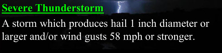
Can we expect severe thunderstorms over the next 24 to 48 hours? Remember that a severe thunderstorm is defined as a thunderstorm that produces 58 mph winds or higher, quarter size hail or larger, and/or a tornado.
Thunderstorm threat level is FOUR.
Severe thunderstorms later today could produce hail, 60 mph winds, and even a tornado.

How much precipitation should we expect over the next few days?
Thunderstorms today could produce very heavy rain in small pockets of the region. Many places could miss out on the late morning and afternoon rain. Those who find themselves under a severe thunderstorm could pick up 0.50″-1.00″ of rain in less than one hour.
A few spots could pick up 0.25″-0.50″ from passing showers and thunderstorms.
Main focus today is on a few supercell thunderstorms.

We have regional radars and local city radars – if a radar does not seem to be updating then try another one. Occasional browsers need their cache cleared. You may also try restarting your browser. That usually fixes the problem. Occasionally we do have a radar go down. That is why I have duplicates. Thus, if one fails then try another one.
If you have any problems then please send me an email beaudodson@usawx.com
WEATHER RADAR PAGE – Click here —
We also have a new national interactive radar – you can view that radar by clicking here.
Local interactive city radars include St Louis, Mt Vernon, Evansville, Poplar Bluff, Cape Girardeau, Marion, Paducah, Hopkinsville, Memphis, Nashville, Dyersburg, and all of eastern Kentucky – these are interactive radars. Local city radars – click here
NOTE: Occasionally you will see ground clutter on the radar (these are false echoes). Normally they show up close to the radar sites – including Paducah.

Regional Radar – Click on radar to take you our full radar page.


Regional Radar

Live Lightning Data – zoom and pan: Click here
Live Lightning Data with sound (click the sound button on the left side of the page): Click here
I also set up a storm tracking page with additional links (use during active weather for quick reference)
Storm Tracking Tool Page

For the most up to date maps – click here


Day 1 Severe Weather Outlook from the Storm Prediction Center – Storm Prediction Center
What does thunderstorms, marginal, slight, enhanced, medium, and high risk mean? Click here

Current Severe thunderstorm and tornado watches from the Storm Prediction Center. The Storm Prediction Center is in charge of issuing watches. Our local National Weather Service Office in Paducah, Kentucky is in charge of issuing warnings.
Remember that a watch means that conditions are favorable for severe weather. Severe weather MIGHT develop over the coming hours. Watches normally last 4 to 8 hours. Monitor updates for possible warnings. A watch is a step below a warning.
A warning means to take immediate action to protect you and your family. Warnings usually last from 15 to 45 minutes. A warning means that a storm is moving into your area.
For additional watch information click here

![]()
Current WARNINGS (a warning means take action now). Click on your county to drill down to the latest warning information. Keep in mind that there can be a 2-3 minute delay in the updated warning information.
I strongly encourage you to use a NOAA Weather Radio or warning cell phone app for the most up to date warning information. Nothing is faster than a NOAA weather radio.


Color shaded counties are under some type of watch, warning, advisory, or special weather statement. Click your county to view the latest information.

Missouri Warnings

Illinois Warnings

Kentucky Warnings

Please visit your local National Weather Service Office by clicking here. The National Weather Service Office, for our region, is located in Paducah, Kentucky. They have a lot of maps and information on their site. Local people…local forecasters who care about our region.

Here is the official 6-10 day and 8-14 day temperature and precipitation outlook. Check the date stamp at the top of each image (so you understand the time frame).
The forecast maps below are issued by the Weather Prediction Center (NOAA).


The latest 8-14 day temperature and precipitation outlook. Note the dates are at the top of the image. These maps DO NOT tell you how high or low temperatures or precipitation will be. They simply give you the probability as to whether temperatures or precipitation will be above or below normal.


Who do you trust for your weather information and who holds them accountable?
I have studied weather in our region since the late 1970’s. I have 37 years of experience in observing our regions weather patterns. My degree is in Broadcast Meteorology from Mississippi State University and an Associate of Science (AS). I am currently working on my Bachelor’s Degree in Geoscience. Just need to finish two Spanish classes!
I am a member of the American Meteorological Society. I am a NOAA Weather-Ready Nation Ambassador. And, I am the Meteorologist for McCracken County Emergency Management.
I own and operate the Southern Illinois Weather Observatory.
There is a lot of noise on the internet. A lot of weather maps are posted without explanation. Over time you should learn who to trust for your weather information.
My forecast philosophy is simple and straight forward.
- Communicate in simple terms
- To be as accurate as possible within a reasonable time frame before an event
- Interact with you on Twitter, Facebook, and the blog
- Minimize the “hype” that you might see on television or through other weather sources
- Push you towards utilizing wall-to-wall LOCAL TV coverage during severe weather events
I am a recipient of the Mark Trail Award, WPSD Six Who Make A Difference Award, Kentucky Colonel, and the Caesar J. Fiamma” Award from the American Red Cross. In 2009 I was presented with the Kentucky Office of Highway Safety Award. I was recognized by the Kentucky House of Representatives for my service to the State of Kentucky leading up to several winter storms and severe weather outbreaks.
If you click on the image below you can read the Kentucky House of Representatives Resolution.

I am also President of the Shadow Angel Foundation which serves portions of western Kentucky and southern Illinois.
Many of my graphics are from www.weatherbell.com – a great resource for weather data, model data, and more


This blog was inspired by ABC 33/40’s Alabama Weather Blog – view their blog
Current tower cam view from the Weather Observatory- Click here for all cameras.

Southern Illinois Weather Observatory

The Weather Observatory

Southern Illinois Weather Observatory
WSIL TV 3 has a number of tower cameras. Click here for their tower camera page & Illinois Road Conditions

Marion, Illinois
WPSD TV 6 has a number of tower cameras. Click here for their tower camera page & Kentucky Road Conditions & Kentucky Highway and Interstate Cameras

Downtown Paducah, Kentucky
Benton, Kentucky Tower Camera – Click here for full view

Benton, Kentucky

I24 Paducah, Kentucky

I24 Mile Point 9 – Paducah, KY

I24 – Mile Point 3 Paducah, Kentucky

You can sign up for my AWARE email by clicking here I typically send out AWARE emails before severe weather, winter storms, or other active weather situations. I do not email watches or warnings. The emails are a basic “heads up” concerning incoming weather conditions.