
.

🌪️ Seven-Day Tornado Outlook ⛈️
April 16th to April 22nd
Current risk: LOW RISK.
Current confidence level: Medium.
Comments: There is a low risk today across the Missouri Bootheel and western Tennessee.
.

Seven-Day Hazardous Weather Outlook
1. Is lightning in the forecast? YES. Lightning is possible today through Saturday evening. Chances will rapidly drop off as we move through Saturday night.
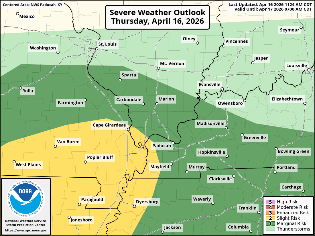
2. Are organized severe thunderstorms. MONITOR. At this time, the threat of widespread severe weather is low. I will monitor today, late Friday night, and Saturday. Perhaps a few intense storms. The concern would be gusty winds and hail. There is a low tornado risk over southern Missouri and western Tennessee this afternoon and evening.
Here is the latest severe weather risk. The dark green and yellow is the area of concern.
3. Is significant or widespread flash flooding in the forecast? NO.
4. Will non-thunderstorm winds top 40 mph? NO.
5. Will the temperature rise above 90 degrees? POSSIBLE. On Friday.
6. Is the heat index forecast to rise above 100 degrees? NO.
.
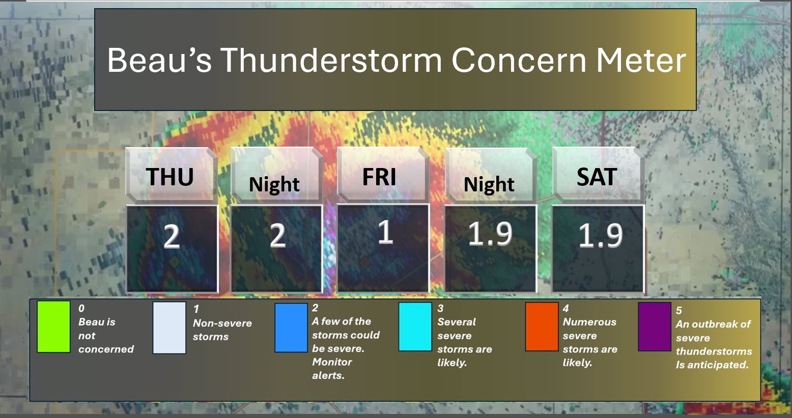
⛈️ Here is the short-range thunderstorm concern meter.
I will monitor this afternoon and then Friday into Saturday.
.
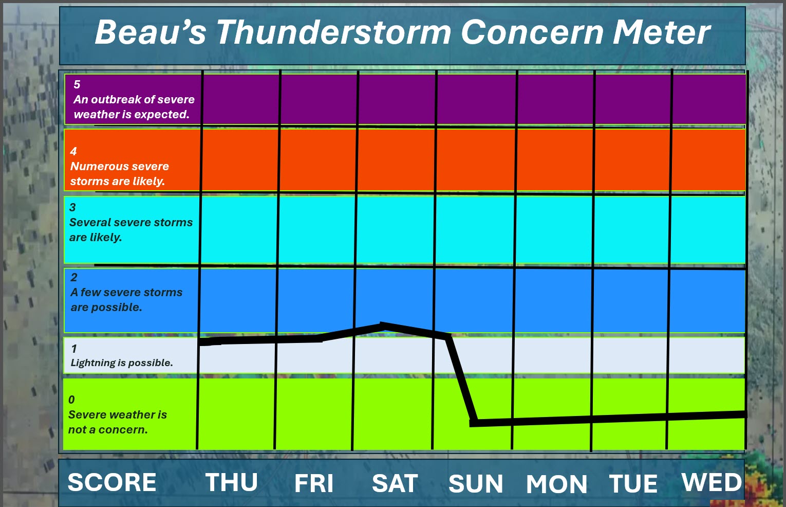
⛈️ Here is the extended thunderstorm concern meter.
I will monitor this afternoon. If storms can redevelop, then some could be intense with gusty winds and hail.
.


.
Here is your bus stop forecast
.
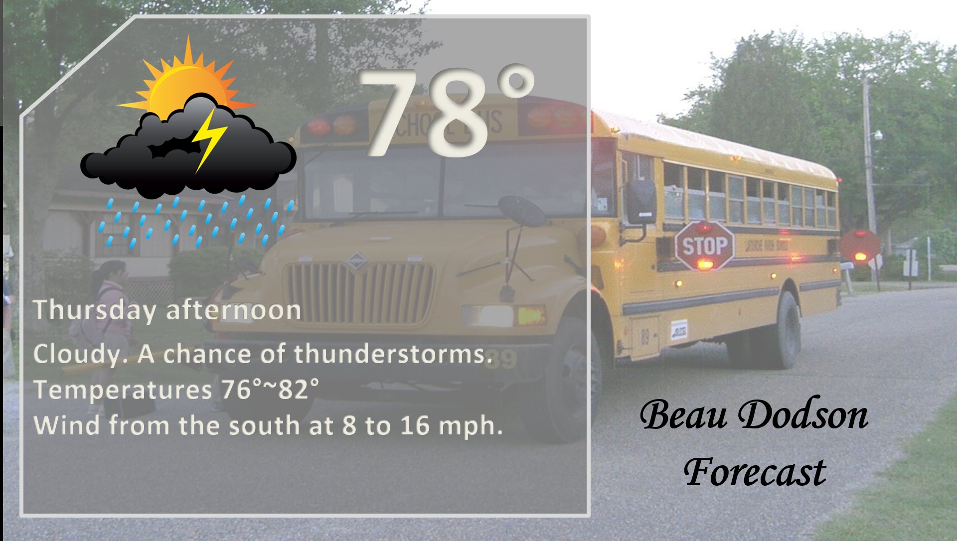
This morning
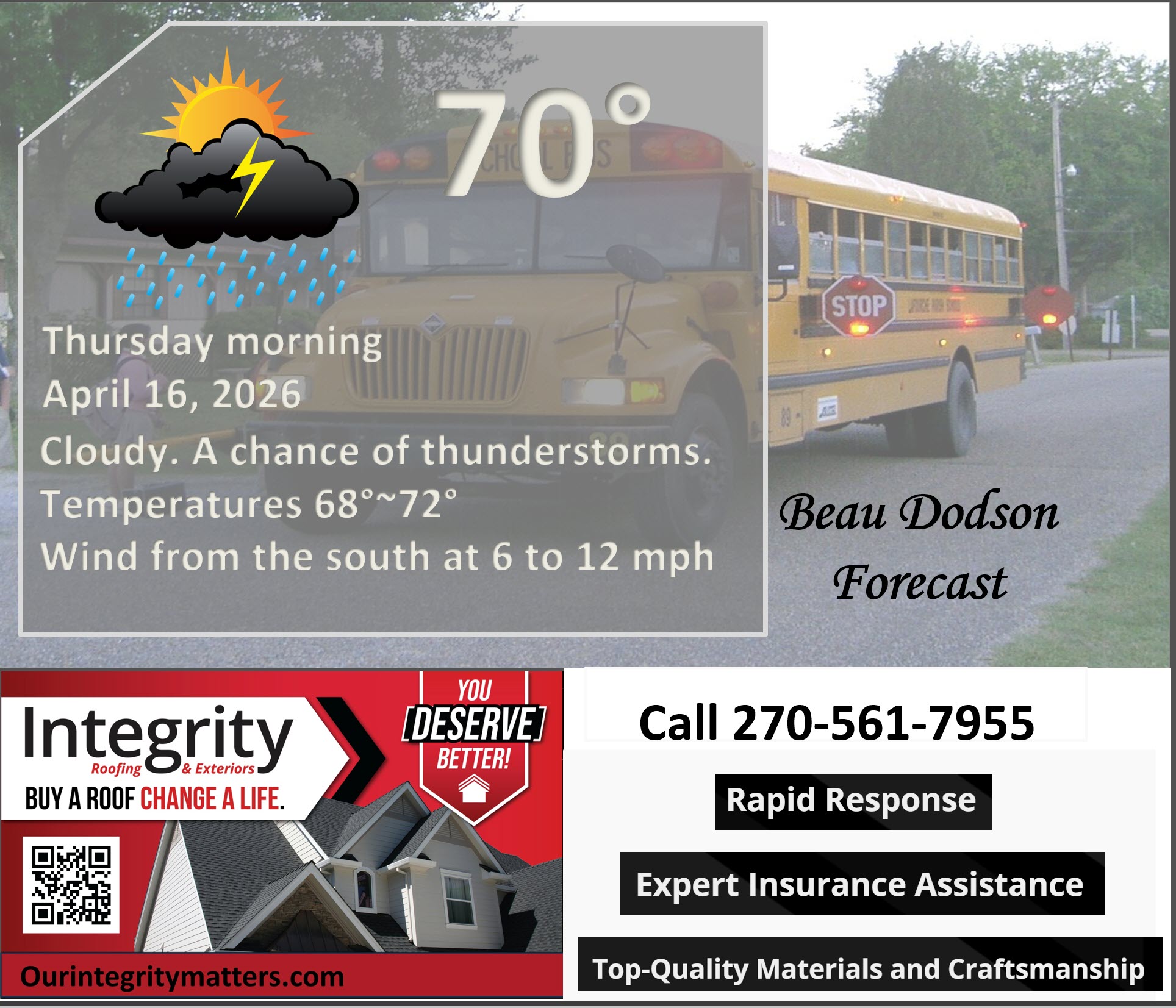
.
This afternoon
.
Tomorrow morning

.
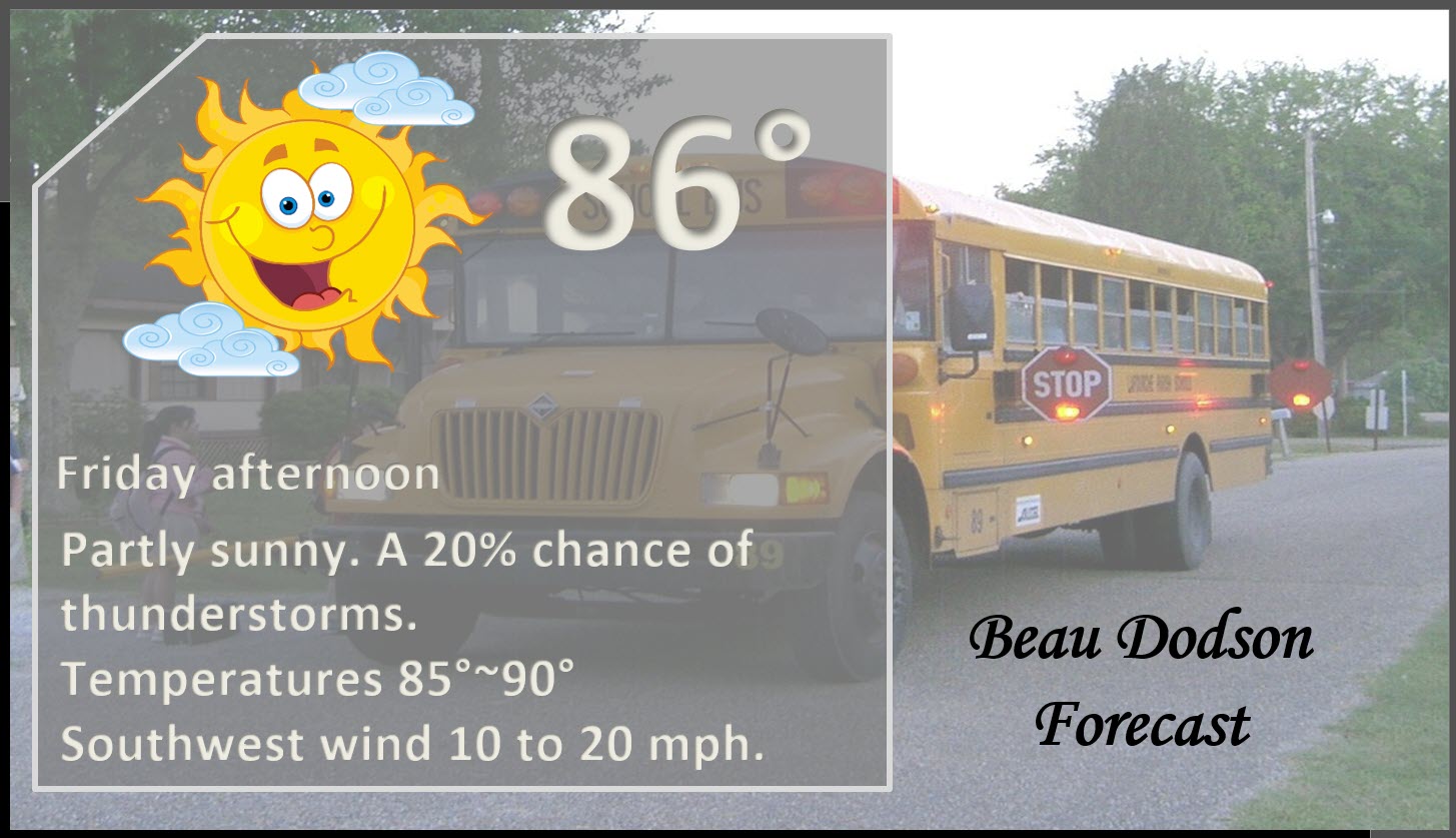
Tomorrow afternoon
.
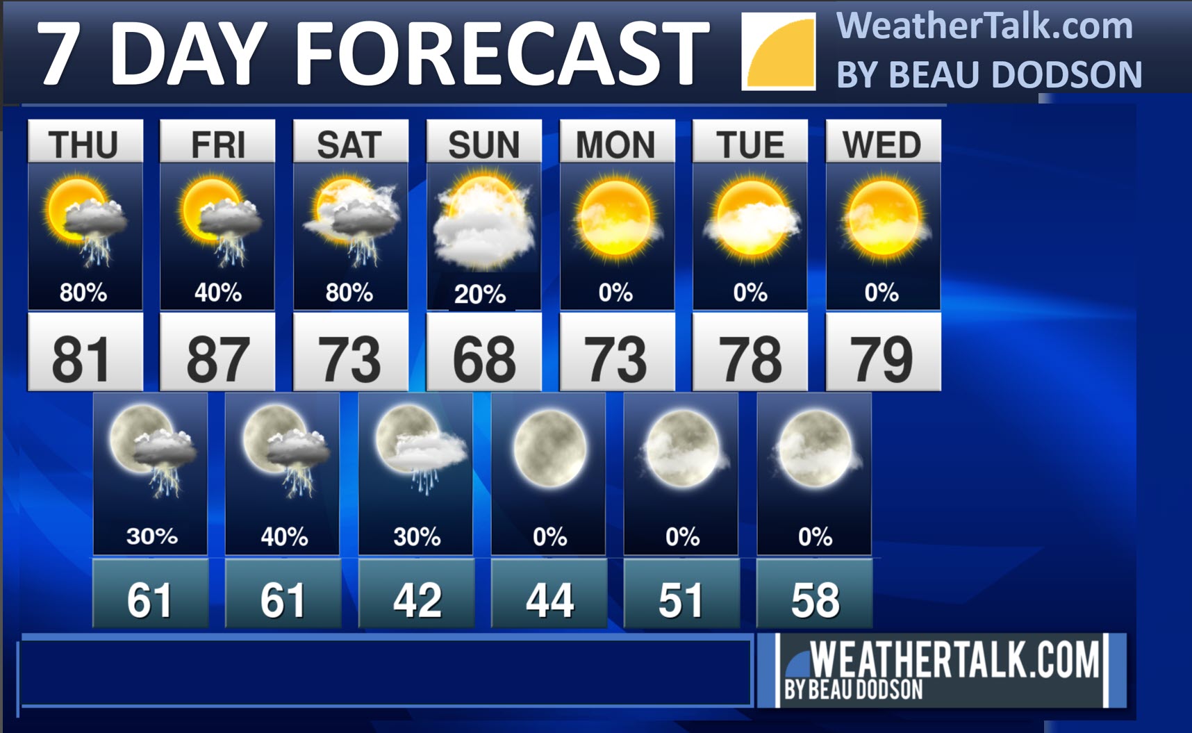
Seven-day outlook graphic.
See the video and graphics below for more details specific to your county. This is a broad-brush overview of the entire region.
.


Forecast discussion
- A chance of showers and thunderstorms today. A few storms could be intense late this afternoon and evening. Mainly over southeast Missouri, extreme southern Illinois, western Kentucky, and northwest Tennessee.
- Near record high temperatures on Friday. It is likely that some areas will break their record high temperatures. Perhaps some record high low temperatures, as well.
- On and off shower and thunderstorm chances today through Saturday evening.
- Peak chances will be late today. Another peak late Friday night into Saturday.
- A few storms could be intense today (low risk) and Friday night/Saturday (low risk).
.
 .
.
.
What is the primary weather concern today and tonight?
A chance of showers and thunderstorms today. If storms redevelop this afternoon, then a few could be intense. Questions remain as to whether the atmosphere can recharge from this morning’s rain and clouds. A bit cooler today. Much warmer tomorrow.
Monitor your Beau Dodson Weather App.
.
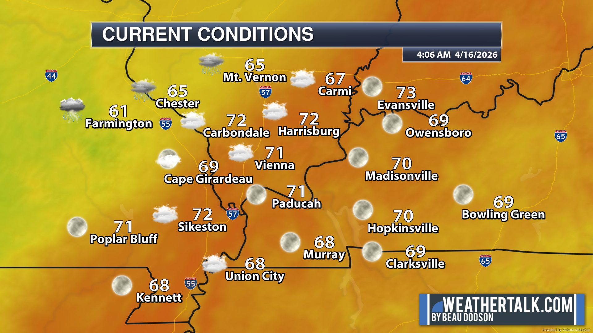
Here are the early morning current conditions. These are the 4 AM readings.
.
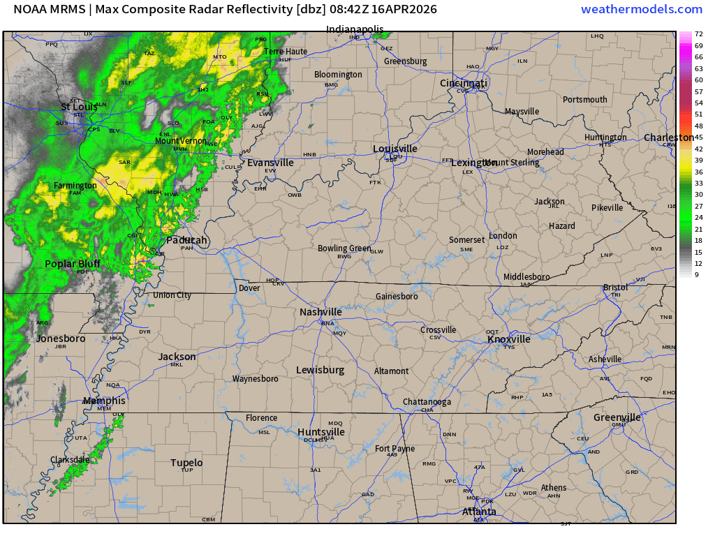
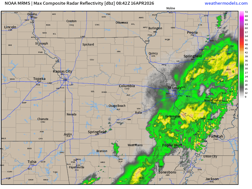
This is what radar looked like at 5 am. The showers are moving along quickly.
Central view.
.
Western view
.

Radars and Lightning Data
Interactive-city-view radars. Clickable watches and warnings.
https://wtalk.co/B3XHASFZ
Old legacy radar site (some of you like it better)
https://weatherobservatory.com/weather-radar.htm
If the radar is not updating then try another one. If a radar does not appear to be refreshing then hit Ctrl F5. You may also try restarting your browser.
Backup radar site in case the above one is not working.
https://weathertalk.com/morani
Regional Radar
https://imagery.weathertalk.com/prx/RadarLoop.mp4
** NEW ** Zoom radar with chaser tracking abilities!
ZoomRadar
.
The new drought monitor maps will be available later today. I will post them in tomorrow’s update. Drought conditions continue to worsen, even though we have received a little bit of rain. It isn’t enough.
We are waking up to showers and thunderstorms rapidly moving through the region. It is patchy on radar. Some of you may receive less than 0.10″ of rain. If you find yourself under a thunderstorm, then rainfall totals will be higher.
No severe weather concerns through 2 PM.
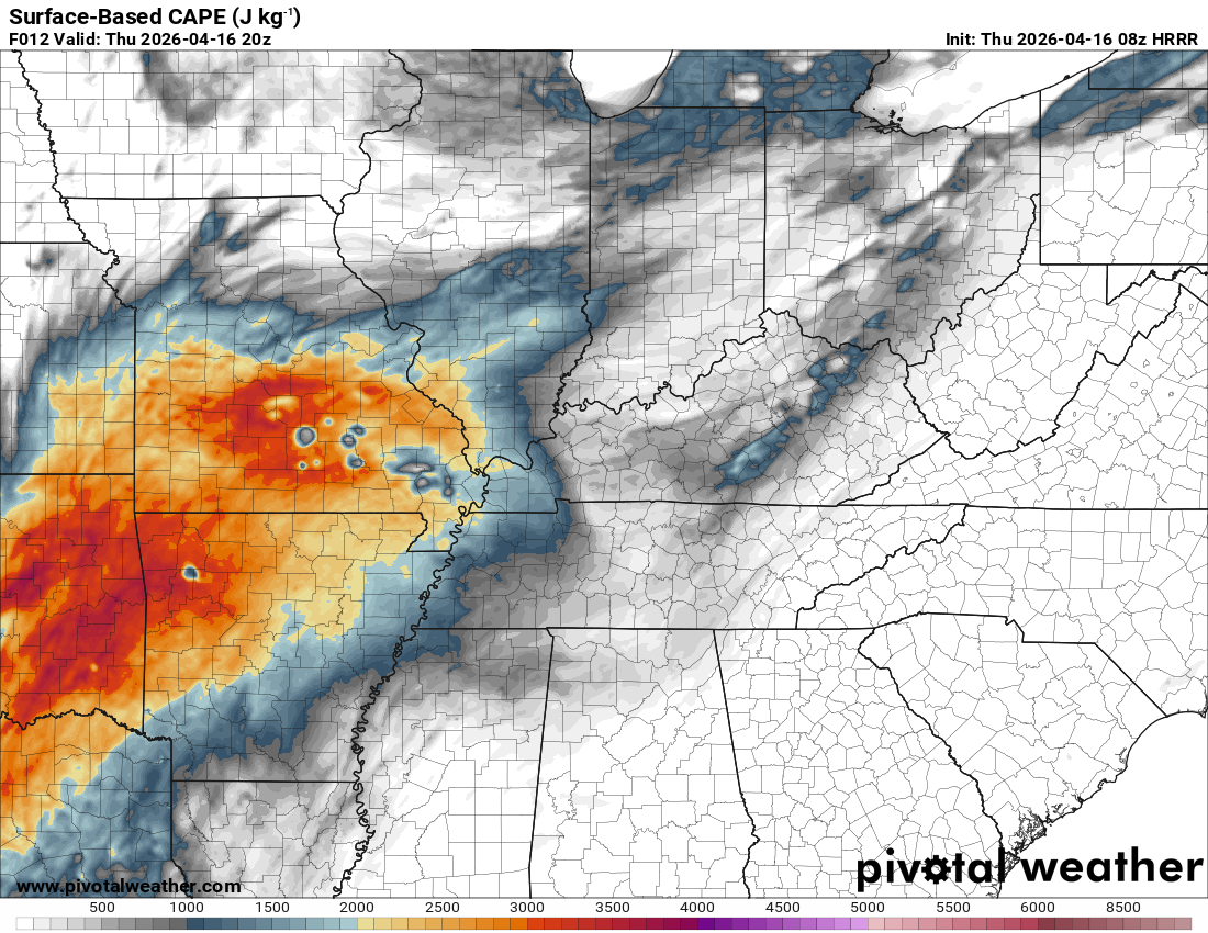
The atmosphere will be worked over this morning and early afternoon. This raises questions as to whether the atmosphere can recover this afternoon and evening.
If the atmosphere recovers and becomes unstable, there will be a chance of a few strong thunderstorms this afternoon and evening.
Here is the CAPE forecast. CAPE is energy that thunderstorms tap into. Higher CAPE numbers equal a higher chance of severe weather.
There are questions about just how much CAPE will be available. For the atmosphere to recover, we need to see the morning activity push eastward and perhaps some broken sunshine. That would mean the atmosphere is becoming more unstable.
.
I will just need to monitor trends in the guidance. Either way, the primary concern will be a few thunderstorms becoming intense this afternoon and evening.
The primary concerns will be 60-mph wind gusts and golfball-sized hail. There is a 40% chance of a few severe thunderstorm warnings this afternoon and evening.
There is a low-end brief tornado risk late this afternoon and evening. Mainly over southeast Missouri, extreme southern Illinois, western Kentucky, and northwest Tennessee.
Again, confidence in severe weather is low due to morning clouds and thunderstorms.
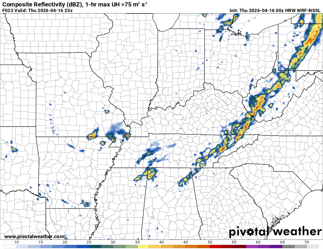
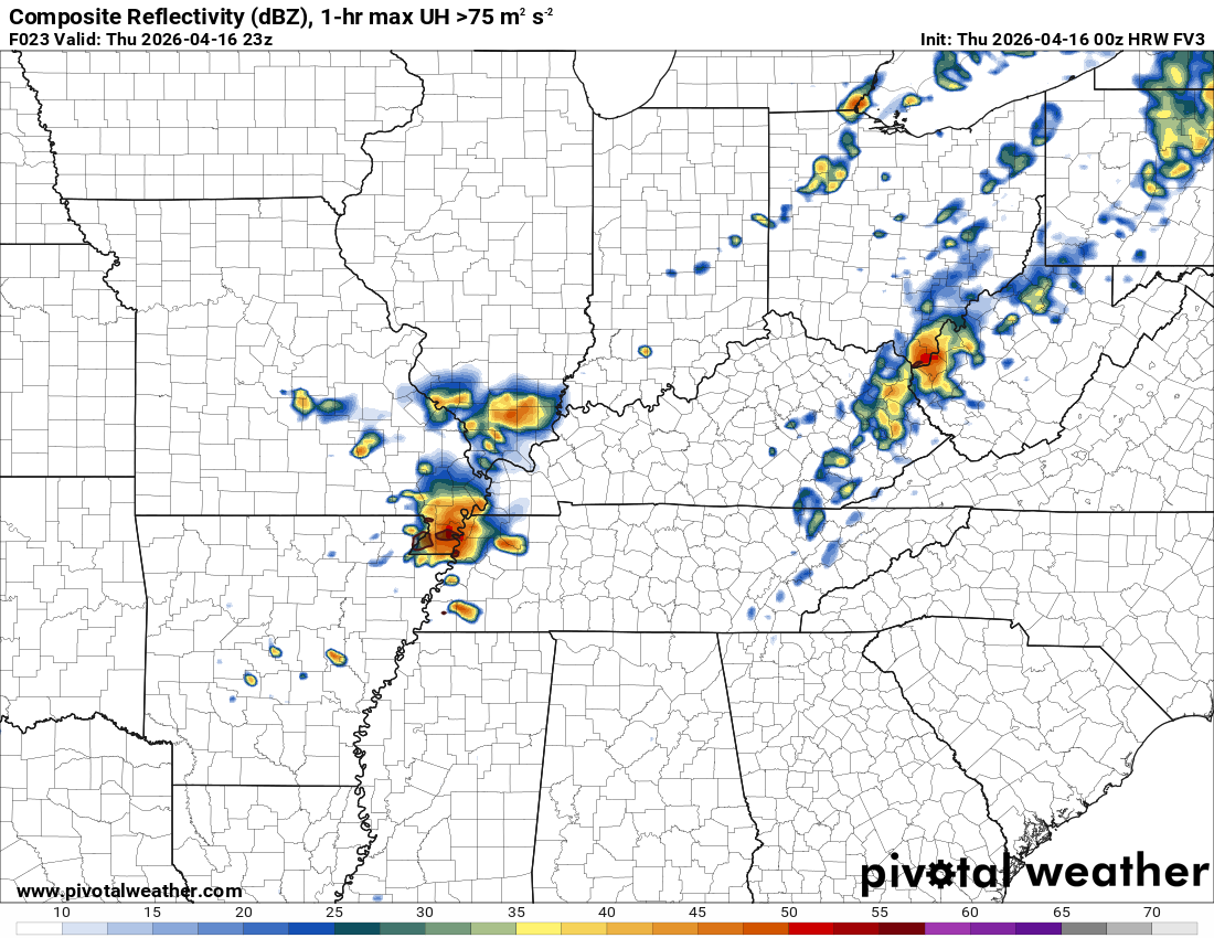
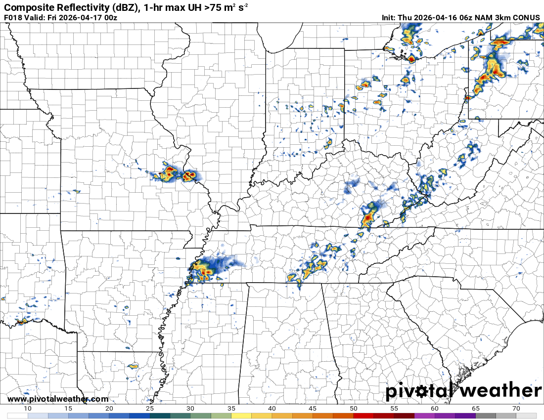
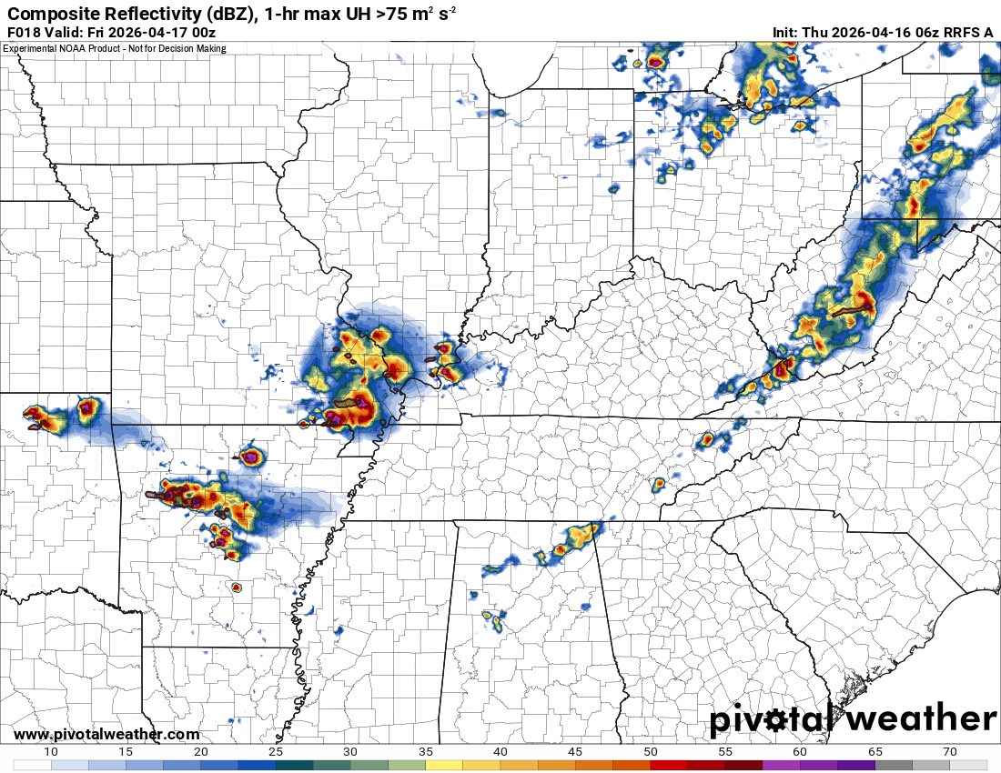
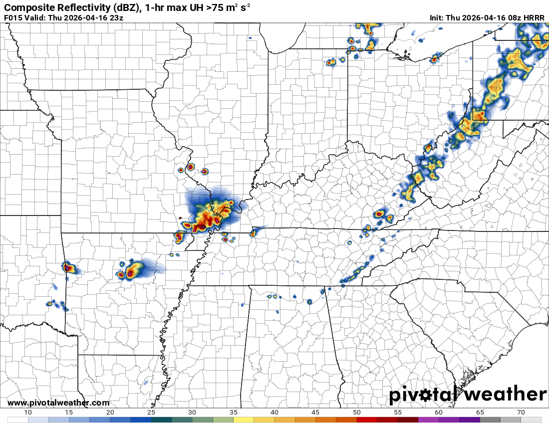
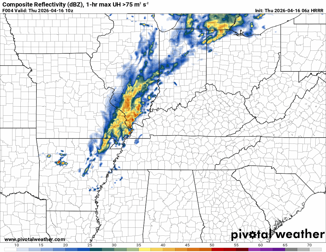
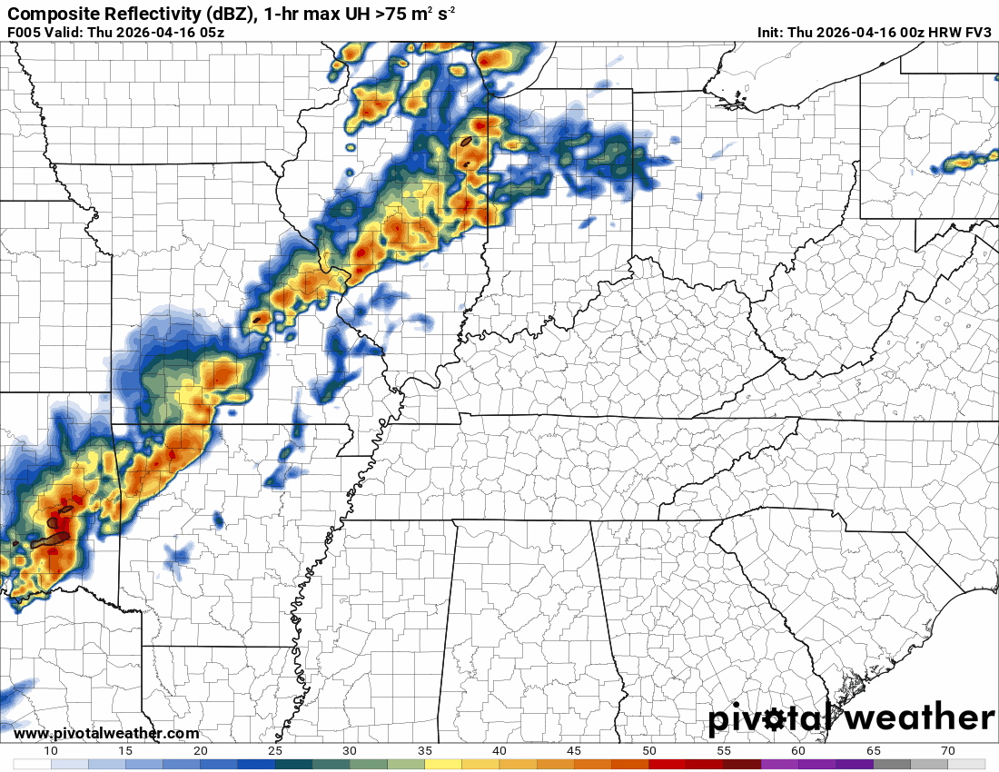
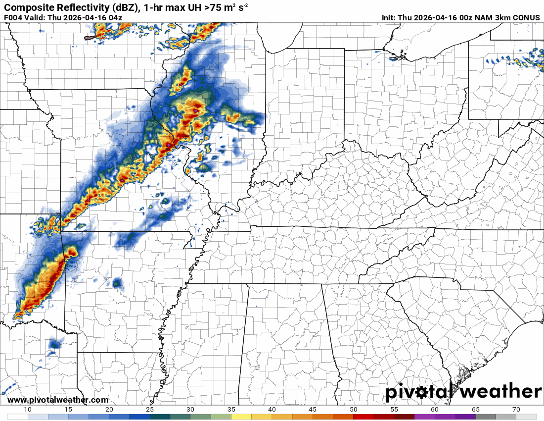
Here are a few models. This is for later today. As you can see, some models do redevelop thunderstorms during the mid to late afternoon hours.
.
WRF NSSL model. Not much in the way of redevelopment.
.
FVS model. It shows some intense storms reforming during the mid to late afternoon hours.
.
NAM 3K model. Shows a few storms trying to redevelop this afternoon (late afternoon).
.
RRFS model (it tends to run too hot) shows storms reforming from mid to late afternoon.
.
The Hrrr model shows some redevelopment during the mid to late afternoon hours (today).
.
The bottom line is that if storms can redevelop, then a few could be strong enough to trigger a severe thunderstorm warning.
Monitor your Beau Dodosn Weather App later today into this evening.
There will be a lull in shower and thunderstorm activity as we move through tonight. Then the chance increases Friday afternoon into Saturday evening.
See the rain probability maps below.
I will monitor Friday night and Saturday for a few intense thunderstorms. For now, the risk appears limited. Monitor updates over the next few days.
As always, during the spring, monitor updated forecasts.
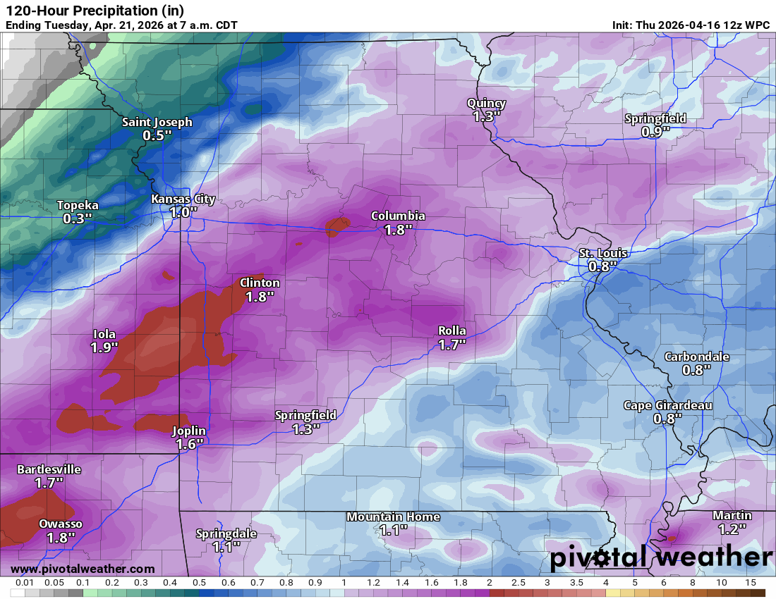
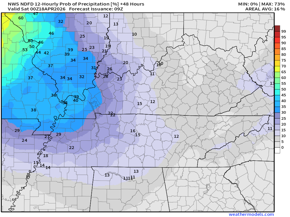
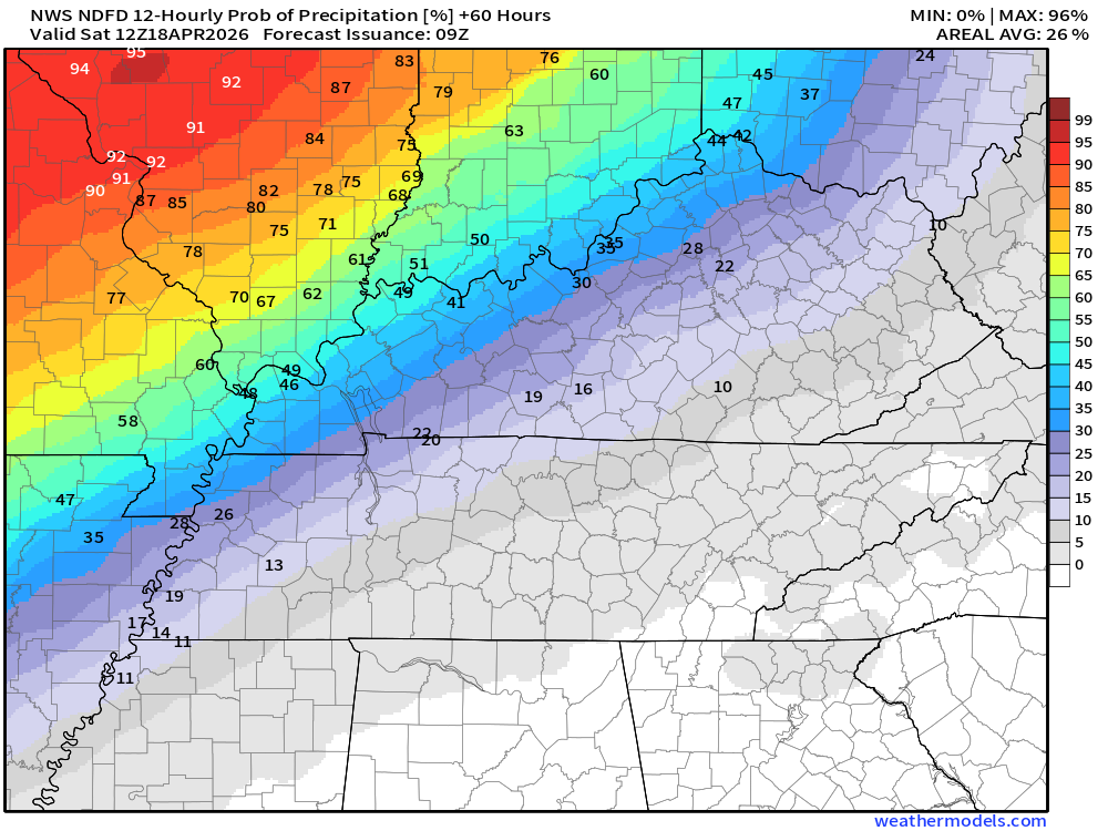
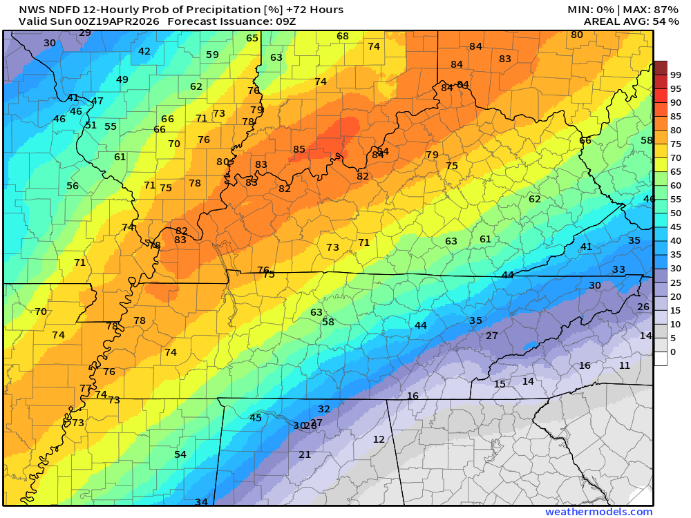
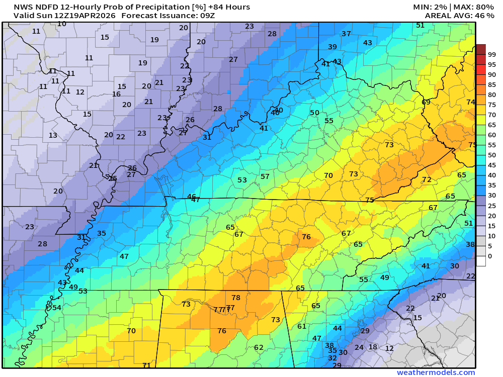
Here are the expected rain totals from today through Sunday.
A lot of the rain, over the past four months, has ended up being less than forecast. We will see how this week goes. We need rain. A lot of rain. Drought conditions continue to worsen.
Double-click on images to enlarge them.
Central view of our region.
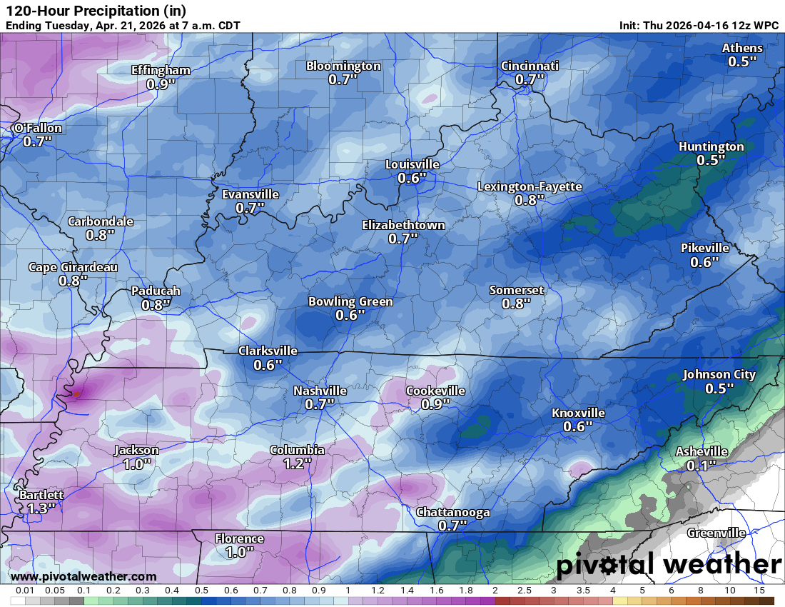
.
Missouri view
.
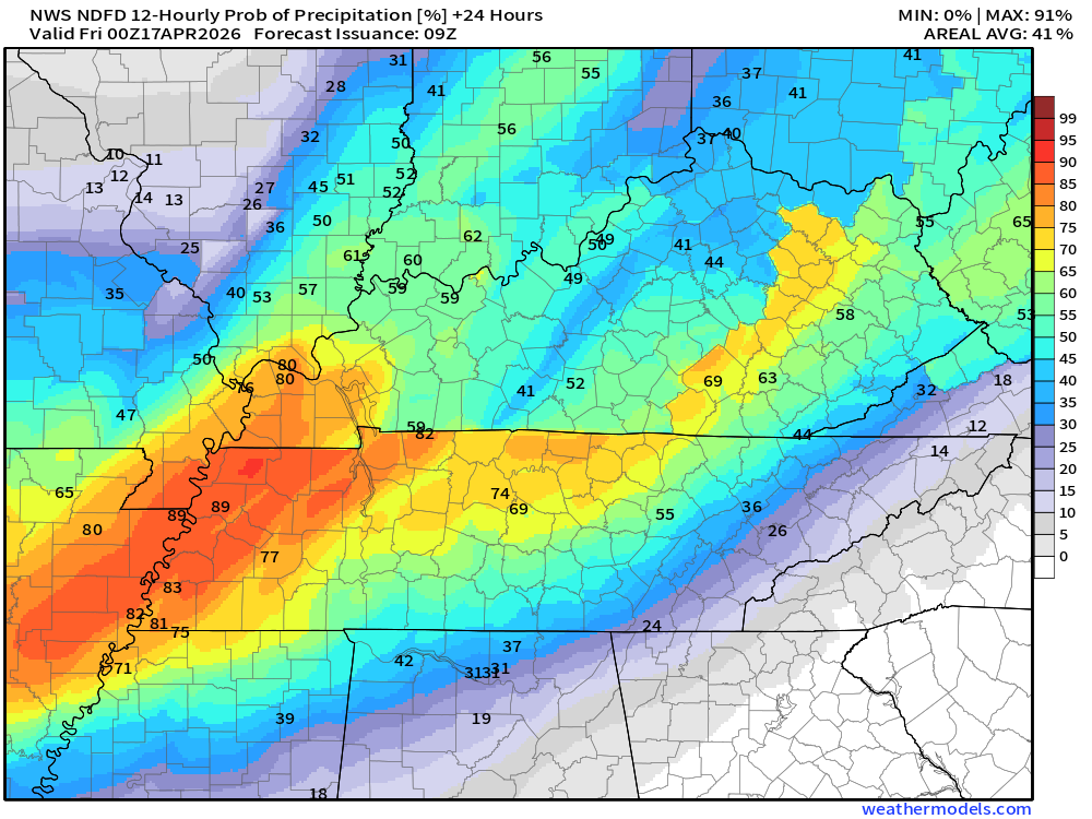
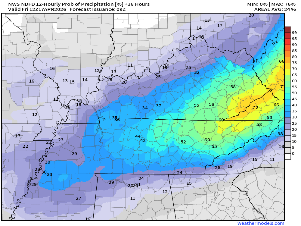
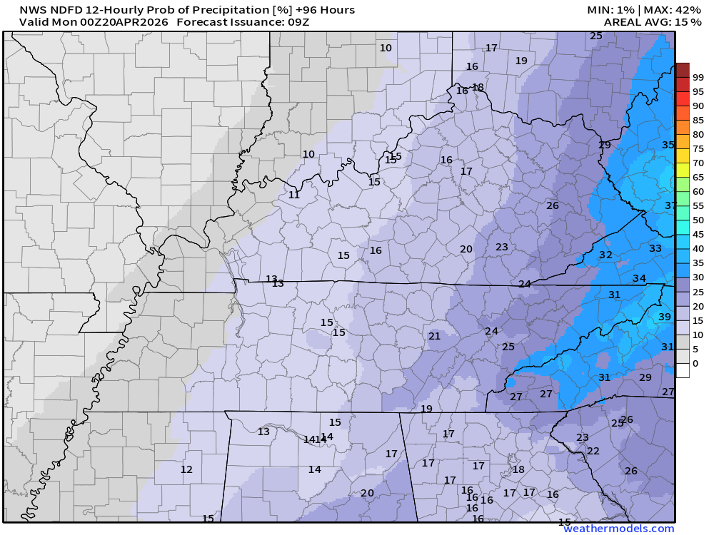
Let’s look at those rain probabilities.
What is the % chance of rain?
Double-click images to enlarge them.
This next graphic is the % chance of rain from 7 AM Thursday to 7 PM Thursday
It will turn cooler on Sunday (behind the cold front). Highs may only reach into the 60s on Sunday.
No frost in the forecast at this time.
.

.
The timestamp (upper left) is in Zulu. 12z=7 am. 18z=1 pm. 00z=7 pm.
Green is rain. Yellow is moderate rain. Orange indicates locally heavy rain.
This model pops most of the storms east northeast of our region (on Thursday PM)
Double-click the animation to enlarge it.
Hrrr Model
.
The timestamp (upper left) is in Zulu. 12z=7 am. 18z=1 pm. 00z=7 pm.
Green is rain. Yellow is moderate rain. Orange indicates locally heavy rain.
Double-click the animation to enlarge it.
FV3 Model
.
The timestamp (upper left) is in Zulu. 12z=7 am. 18z=1 pm. 00z=7 pm.
Green is rain. Yellow is moderate rain. Orange indicates locally heavy rain.
Double-click the animation to enlarge it.
NAM 3K Model
.
..
.
Click here if you would like to return to the top of the page.
.Average high temperatures for this time of the year are around 68 degrees.
Average low temperatures for this time of the year are around 45 degrees.
Average precipitation during this time period ranges from 1.00″ to 1.20″
Six to Ten Day Outlook.
Blue is below average. Red is above average. The no color zone represents equal chances.
Average highs for this time of the year are in the lower 60s. Average lows for this time of the year are in the lower 40s.

Green is above average precipitation. Yellow and brown favors below-average precipitation. Average precipitation for this time of the year is around one inch per week.

.

Average low temperatures for this time of the year are around 46 degrees.
Average precipitation during this time period ranges from 1.00″ to 1.30″
.
Eight to Fourteen Day Outlook.
Blue is below average. Red is above average. The no color zone represents equal chances.

Green is above average precipitation. Yellow and brown favors below average precipitation. Average precipitation for this time of the year is around one inch per week.

.
.
.
We have a new service to complement your www.weathertalk.com subscription. This does NOT replace www.weathertalk.com It is simply another tool for you to receive severe weather information.
.
https://weathercallservices.com/beau-dodson-weather


Want to receive the daily forecast/other products on your Beau Dodson Weather app?
Did you know you have four options in your www.weathertalk.com account
You will then receive these via your Beau Dodson Weather app.
Just log into your www.weathertalk.com account
Click the NOTIFICATION SETTINGS TAB
Then, turn them on (green) and off (red)
🌪️ Number 1 is the most important one. Severe alerts, tornado alerts, and so on.
Number 2 is the daily video, blog, livestream alerts, and severe weather Facebook threads on severe days or winter storm days.
Number 3 is the daily forecast. I send that out every day during the afternoon hours. It is the seven-day forecast, hazardous weather outlook, fire outlook, and more.
Number 4 is to receive the daily video, blog, and other content on NON-severe weather days (every day without severe threats in other words)
GREEN IS ON
RED IS OFF

Radars and Lightning Data
Interactive-city-view radars. Clickable watches and warnings.
https://wtalk.co/B3XHASFZ
Old legacy radar site (some of you like it better)
https://weatherobservatory.com/weather-radar.htm
If the radar is not updating then try another one. If a radar does not appear to be refreshing then hit Ctrl F5. You may also try restarting your browser.
Backup radar site in case the above one is not working.
https://weathertalk.com/morani
Regional Radar
https://imagery.weathertalk.com/prx/RadarLoop.mp4
** NEW ** Zoom radar with chaser tracking abilities!
ZoomRadar
If the radar is not working, then email me: Email me at beaudodson@usawx.com
.
We do have some sponsors! Check them out.
Roof damage from recent storms? Link – Click here
INTEGRITY ROOFING AND EXTERIORS!
⛈️ Roof or gutter damage from recent storms? Today’s weather is sponsored by Integrity Roofing. Check out their website at this link https://www.ourintegritymatters.com/

![]()
![]()
![]()
Make sure you have three to five ways of receiving your severe weather information.
Weather Talk is one of those ways! Now, I have another product for you and your family.

.
Want to add more products to your Beau Dodson Weather App?
Receive daily videos, weather blog updates on normal weather days and severe weather and winter storm days, your county by county weather forecast, and more!
Here is how to do add those additional products to your app notification settings!
Here is a video on how to update your Beau Dodson Weather payment.
The app is for subscribers. Subscribe at www.weathertalk.com/welcome then go to your app store and search for WeatherTalk
Subscribers, PLEASE USE THE APP. ATT and Verizon are not reliable during severe weather. They are delaying text messages.
The app is under WeatherTalk in the app store.

Apple users click here

Android users click here
.
Radars and Lightning Data
Interactive-city-view radars. Clickable watches and warnings.
https://wtalk.co/B3XHASFZ
Old legacy radar site (some of you like it better)
https://weatherobservatory.com/weather-radar.htm
If the radar is not updating then try another one. If a radar does not appear to be refreshing then hit Ctrl F5. You may also try restarting your browser.
Backup radar site in case the above one is not working.
https://weathertalk.com/morani
Regional Radar
https://imagery.weathertalk.com/prx/RadarLoop.mp4
** NEW ** Zoom radar with chaser tracking abilities!
ZoomRadar
Lightning Data (zoom in and out of your local area)
https://wtalk.co/WJ3SN5UZ
Not working? Email me at beaudodson@usawx.com
National map of weather watches and warnings. Click here.
Storm Prediction Center. Click here.
Weather Prediction Center. Click here.
.

Live lightning data: Click here.
Real time lightning data (another one) https://map.blitzortung.org/#5.02/37.95/-86.99
Our new Zoom radar with storm chases
.
.

Interactive GOES R satellite. Track clouds. Click here.
GOES 16 slider tool. Click here.
College of DuPage satellites. Click here
.

Here are the latest local river stage forecast numbers Click Here.
Here are the latest lake stage forecast numbers for Kentucky Lake and Lake Barkley Click Here.
.
.
Find Beau on Facebook! Click the banner.


 .
.