We have some great sponsors for the Weather Talk Blog. Please let our sponsors know that you appreciate their support for the Weather Talk Blog.
Milner and Orr Funeral Home and Cremation Services located in Paducah, Kentucky and three other western Kentucky towns – at Milner and Orr they believe in families helping families. You can find Milner and Orr on Facebook, as well.
![]()
.

For all of your families eye care needs. Visit their web-site here. Or, you can also visit their Facebook page.
.

Best at Enabling Body Shop Profitability since 1996. Located In Paducah Kentucky and Evansville Indiana; serving all customers in between. They provide Customer Service, along with all the tools necessary for body shops to remain educated and competitive. Click the logo above for their main web-site. You can find McClintock Preferred Finishes on Facebook, as well

Expressway Carwash and Express Lube are a locally owned and operated full service Carwash and Lube established in 1987. We have been proudly serving the community for 29 years now at our Park Avenue location and 20 years at our Southside location. We have been lucky enough to partner with Sidecar Deli in 2015, which allows us to provide our customers with not only quality service, but quality food as well. . If you haven’t already, be sure to make Expressway your one stop shop, with our carwash, lube and deli. For hours of operation and pricing visit www.expresswashlube.com or Expressway Carwash on Facebook.

TORNADO SHELTERS! Endrizzi’s Storm Shelters – For more information click here. Endrizzi Contracting and Landscaping can be found on Facebook, as well – click here
I have launched the new weather texting service! I could use your help. Be sure and sign up and fully support all of the weather data you see each day.
This is a monthly subscription service. Supporting this helps support everything else. The cost is $3 a month for one phone, $5 a month for three phones, and $10 a month for seven phones.
For more information visit BeauDodsonWeather.com
Or directly sign up at Weathertalk.com


This forecast update covers far southern Illinois, far southeast Missouri, and far western Kentucky. See the coverage map on the right side of the blog.
Remember that weather evolves. Check back frequently for updates, especially during active weather.

FROST FORECAST:
Frost update for the orchards/others.
Sunday night – No concerns for frost
Monday night -No concerns for frost
Tuesday night – Monitor updates
Wednesday night – Monitor updates
Thursday night – Monitor updates
Sunday Night – Blowing dust early in the evening over the Missouri Bootheel. Dust storm warning in effect for that area. Mostly cloudy. An increasing chance for showers. Thunderstorms possible overnight.
Temperatures: Lows in the 56-65 degree range.
Winds: Winds south at 12 mph with gusts to 15-25 mph.
What is the chance for precipitation? 40% before midnight and then 60% after midnight
Coverage of precipitation? Scattered to becoming widespread (especialy for the western and northern half of the region)
My confidence in this part of the forecast verifying is High
Should I be concerned about snow or ice? No
Should I cancel my outdoor plans? No, but some showers possible
Is severe weather expected? Unlikely. A few storms could produce hail in Missouri (more towards St Louis than our area). Severe weather risk in our area is small.
What impact is expected? Maybe wet roadways. Perhaps lightning. Severe blowing dust over the Missouri Bootheel. Winds over 50 mph over the Bootheel area of Missouri.
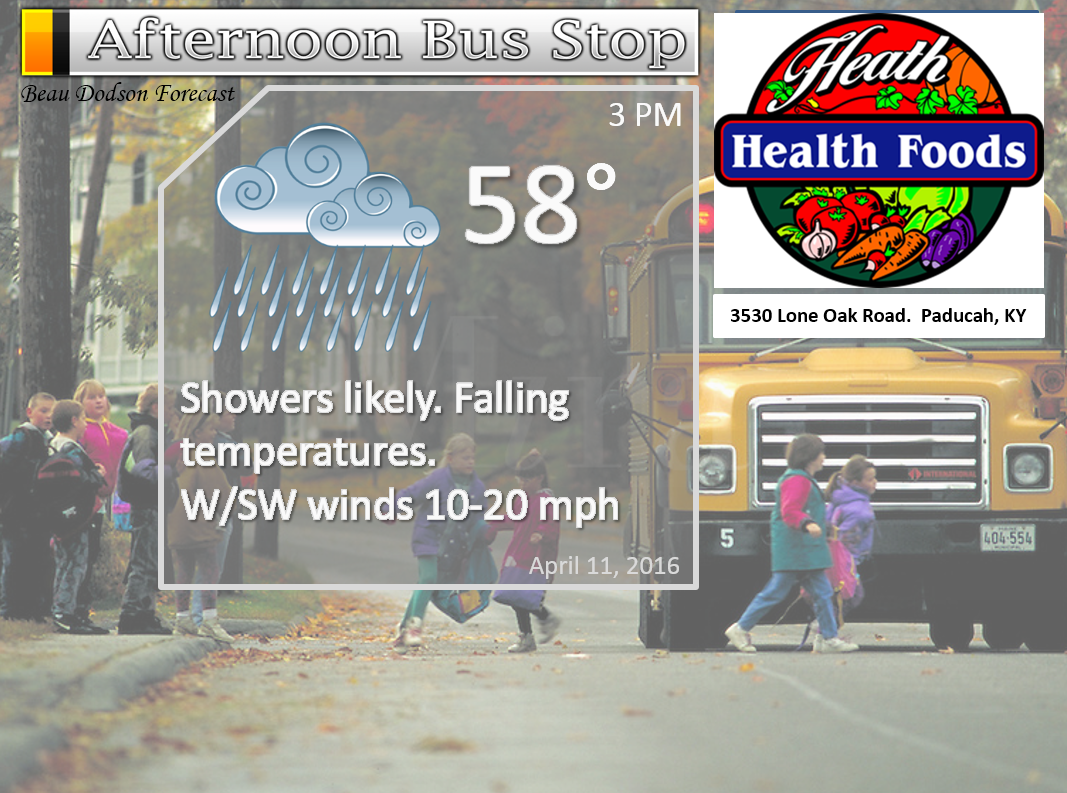
Monday – Cloudy. Widespread showers. Thunder possible. Some heavy downpours possible. Rain will spread from west/north towards the south and east. Temperatures may fall during the afternoon hours. This, as a cold front moves southward.
Temperatures: High temperatures in the lower to middle 60s. Temperatures falling in the afternoon.
Winds: Southerly winds at 8-16 mph. Gusty winds at times ahead of our next system. Winds becoming more west and northwest behind the cold front.
What is the chance for precipitation? 80%
Coverage of precipitation? Widespread
My confidence in this part of the forecast verifying is High
Should I be concerned about snow or ice? No
Should I cancel my outdoor plans? Have a plan B
Is severe weather expected? Unlikely
What impact is expected? Wet roadways. Lightning possible.
Monday Night – Mostly cloudy. Showers. A rumble of thunder possible early. Rain lingers the longer over western Kentucky and western Tennessee. Rain ends from northwest to southeast.
Temperatures: Lows in the 38 to 44 degree range
Winds: Winds becoming northwest and north at 10-20 mph. Gusty winds, at times.
What is the chance for precipitation? 70% southern counties and 40% northern counties. North being from Farmington, MO towards Carmi, IL. Better chances for rain the further south you travel in the region.
Coverage of precipitation? Widespread (especially southern half of the region)
My confidence in this part of the forecast verifying is High
Should I be concerned about snow or ice? No
Should I cancel my outdoor plans? Some showers and storms are possible Monday and Monday night. Have a back up plan.
Is severe weather expected? No
What impact is expected? Wet roadways. Lightning possible.
Tuesday – Partly cloudy.
Winds: North and northeast winds at 6-12 mph. Gusts to 15 mph.
What is the chance for precipitation? 10%
Coverage of precipitation? Rain should come to an end by Tuesday morning.
My confidence in this part of the forecast verifying is Medium
Should I be concerned about snow or ice? No
Should I cancel my outdoor plans? No
Is severe weather expected? No
What impact is expected? Likely none.
Tuesday Night – Clearing and cold. Frost possible. Some uncertainty on frost potential on Tuesday night. Monitor updates.
Temperatures: Lows in the 34-38 degree range.
Winds: Winds north and northeast at 5-10 mph
What is the chance for precipitation? 0%
Coverage of precipitation? None
My confidence in this part of the forecast verifying is High
Should I be concerned about snow or ice? No
Should I cancel my outdoor plans? No
Is severe weather expected? No
What impact is expected? Monitoring for frost. Otherwise, none.
Wednesday – Mostly sunny and cool.
Temperatures: High temperatures from 58 to 64 degrees.
Winds: North and northeast winds at 10 mph.
What is the chance for precipitation? 0%
Coverage of precipitation? None
My confidence in this part of the forecast verifying is High
Should I be concerned about snow or ice? No
Should I cancel my outdoor plans? No
Is severe weather expected? No
What impact is expected? None
Wednesday Night – Clearing and cool. Will monitor temperatures for frost conditions.
Temperatures: Lows from 36 to 44 degrees.
Winds: Winds northeast at 5 mph
What is the chance for precipitation? 0%
Coverage of precipitation? None
My confidence in this part of the forecast verifying is High
Should I be concerned about snow or ice? No
Should I cancel my outdoor plans? No
Is severe weather expected? No
What impact is expected? Most likely none.
Thursday – Mostly sunny and mild.
Temperatures: High temperatures 64-68 degrees
Winds: Northeast/east winds at 10 mph.
What is the chance for precipitation? 0%
Coverage of precipitation? None
My confidence in this part of the forecast verifying is Medium
Should I be concerned about snow or ice? No
Should I cancel my outdoor plans? No
Is severe weather expected? No
What impact is expected? None
Thursday Night – A few passing clouds. Otherwise, mostly clear. Cool.
Temperatures: Lows in the lower to middle 40s
Winds: Winds south and southeast at 4-8 mph.
What is the chance for precipitation? 0%
Coverage of precipitation? None
My confidence in this part of the forecast verifying is High
Should I be concerned about snow or ice? No
Should I cancel my outdoor plans? No
Is severe weather expected? No
What impact is expected? None
Friday – Mostly sunny. Warmer. Spring.
Temperatures: High temperatures 68-72 degrees.
Winds: South winds at 6-12 mph.
What is the chance for precipitation? 0%
Coverage of precipitation? None
My confidence in this part of the forecast verifying is Medium
Should I be concerned about snow or ice? No
Should I cancel my outdoor plans? No
Is severe weather expected? No
What impact is expected? None
Friday Night – A few clouds. Small chance for a shower.
Temperatures: Lows in the lower 50s
Winds: Winds south at 4-8 mph.
What is the chance for precipitation? 10%
Coverage of precipitation? None to isolated
My confidence in this part of the forecast verifying is High
Should I be concerned about snow or ice? No
Should I cancel my outdoor plans? No
Is severe weather expected? No
What impact is expected? None
Saturday – Partly to mostly sunny. Warmer. Spring.
Temperatures: High temperatures 70-75 degrees.
Winds: South winds at 6-12 mph.
What is the chance for precipitation? 10%
Coverage of precipitation? None
My confidence in this part of the forecast verifying is Medium
Should I be concerned about snow or ice? No
Should I cancel my outdoor plans? No
Is severe weather expected? No
What impact is expected? None
Saturday Night – Mostly clear.
Temperatures: Lows in the lower 50s
Winds: Winds south at 4-8 mph.
What is the chance for precipitation? 0%
Coverage of precipitation? None
My confidence in this part of the forecast verifying is High
Should I be concerned about snow or ice? No
Should I cancel my outdoor plans? No
Is severe weather expected? No
What impact is expected? None
Sunday – Partly sunny. Warmer. Spring.
Temperatures: High temperatures 73-76 degrees.
Winds: South winds at 8-16 mph.
What is the chance for precipitation? 0%
Coverage of precipitation? None
My confidence in this part of the forecast verifying is Medium
Should I be concerned about snow or ice? No
Should I cancel my outdoor plans? No
Is severe weather expected? No
What impact is expected? None
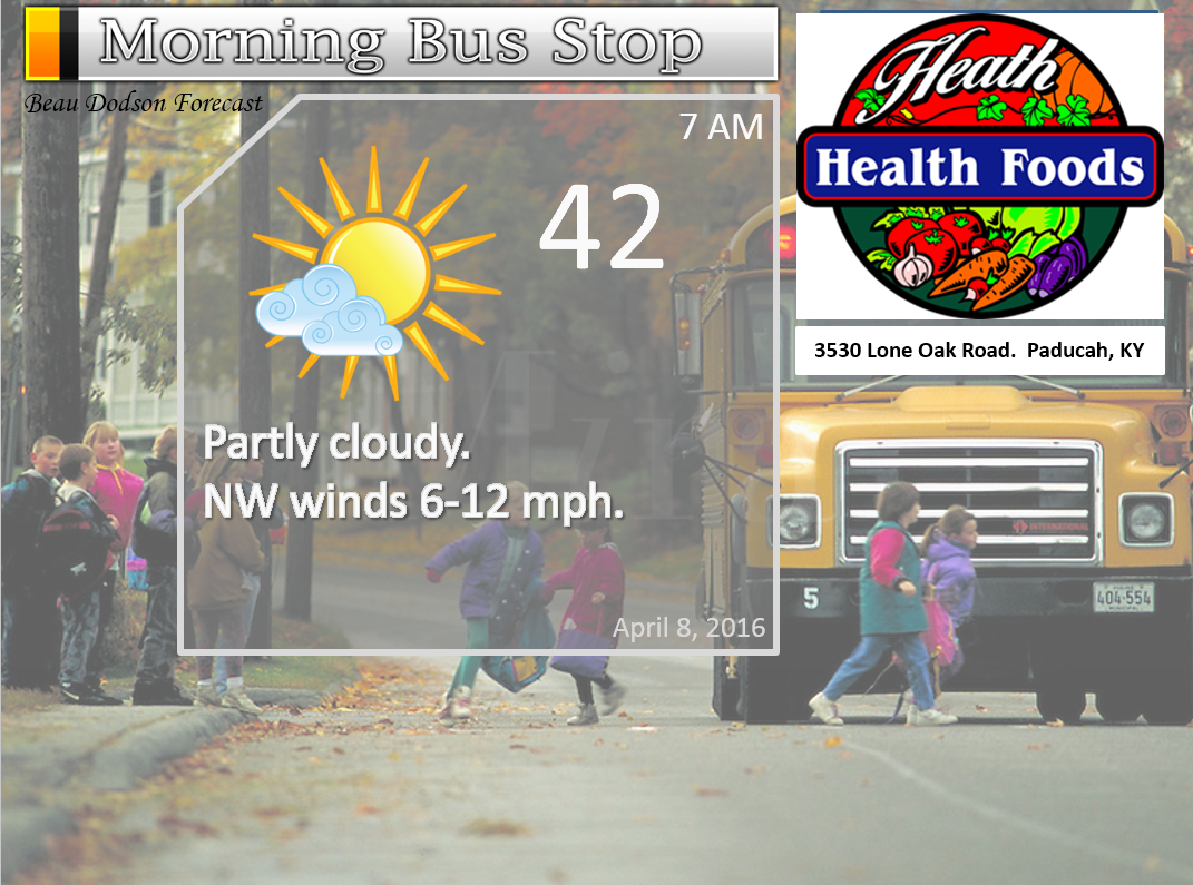
The School Bus Stop Forecast is sponsored by Heath Health and Wellness. Located next to Crowell Pools in Lone Oak, Kentucky.
Visit their web-site here. And. visit Heath Health Foods on Facebook!

The School Bus Stop Forecast is sponsored by Heath Health and Wellness. Located next to Crowell Pools in Lone Oak.

Heath Health Foods is a locally owned and operated retail health and wellness store. Since opening in February 2006; the store has continued to grow as a ministry with an expanding inventory which also offers wellness appointments and services along with educational opportunities. Visit their web-site here. And. visit Heath Health Foods on Facebook!

Don’t forget to check out the Southern Illinois Weather Observatory web-site for weather maps, tower cams, scanner feeds, radars, and much more! Click here

An explanation of what is happening in the atmosphere over the coming days…
- Rain in the forecast
- Monitoring for frost chances on Wednesday morning
- Warming trend from Thursday into the weekend
- Spring like next weekend? Let’s hope!
The main weather story over the next 24-36 hours will be a cold front that will push southward on Monday and Monday night. Widespread showers and thunderstorms are anticipated for Sunday night into Monday morning just to our west and north. This area of showers and storms will sag southward on Monday morning and afternoon.
There could be a few scattered showers and thunderstorms at just about any given time Sunday night into Monday morning. But, the more general and widespread rain should arrive through the day on Monday. First arriving late Sunday night and early Monday morning over western parts of southeast Missouri and northern parts of southeast Missouri and southern Illinois. Then spreading south and east with time.
I am expecting rainfall totals to be between 0.30″-0.60″. There will be a band of heavier totals just a tad to our north or perhaps over our northern counties. That would be more towards Farmington, MO into the Carmi, IL region. South of there totals are expected to be a bit less. The heavier rain band, mentioned above, could top one inch. I will post some graphics below.
Severe weather is once again not anticipated. It has been a very quiet year for severe storms in our region. We have had a couple of events that produced spotty severe weather. But, for the second year in a row we are averaging below normal in the severe weather department. Let’s hope the rest of spring delivers the same.
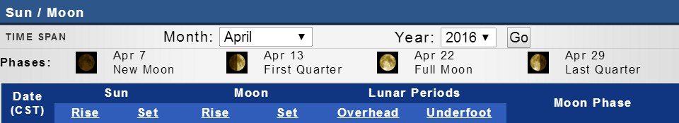
It will turn colder on Tuesday night. Temperatures should dip into the 30s on Wednesday morning. I will be monitoring for frost.
Let’s look at a series of map.
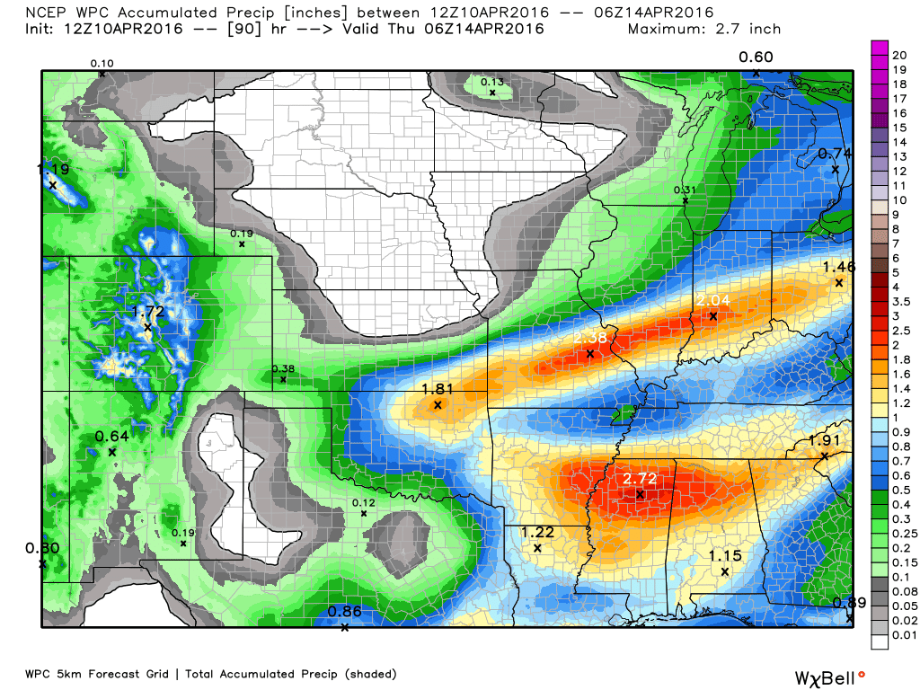
I want to show you the forecasted rainfall totals from a few models. You can see the heavier band I mentioned for our northern counties.
Here is the WPC forecast rainfall totals. Notice the split north and south for heavier totals. Scale is on the right side of the image. Click for a larger view. Image is from weatherbell.com
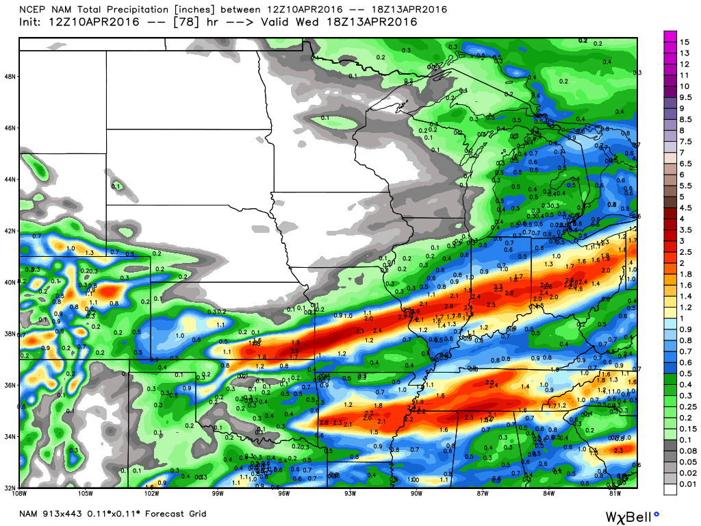
Here is the NAM guidance and what it is forecasting for totals. Scale is on the right side of the image. Click for larger image. Image is from weatherbell.com
Again, you can see the split
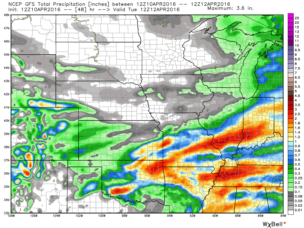
Here is the GFS guidance and what it is forecasting for totals. Click for larger image. Image is from weatherbell.com
The GFS also shows the split.
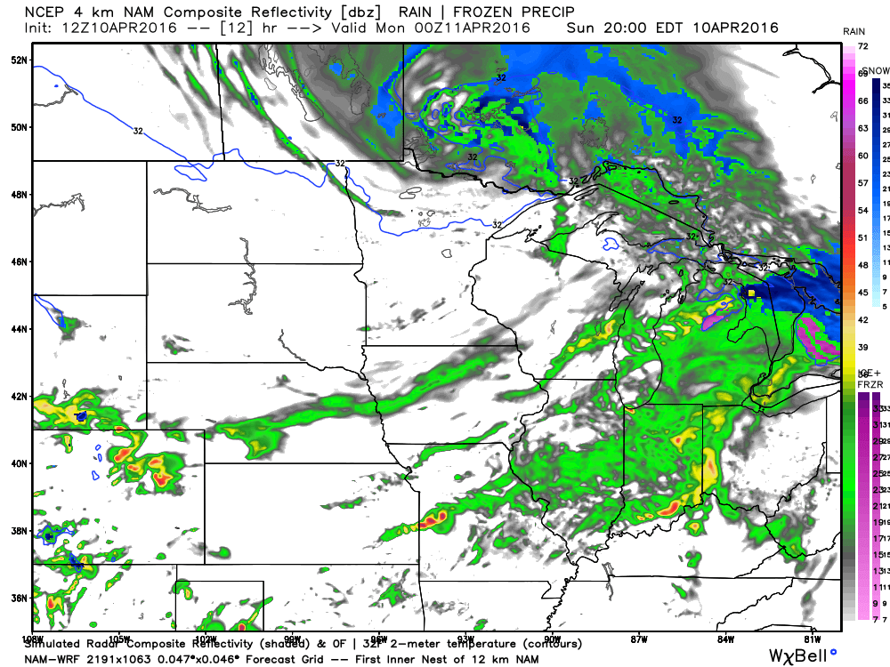
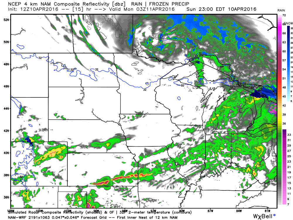
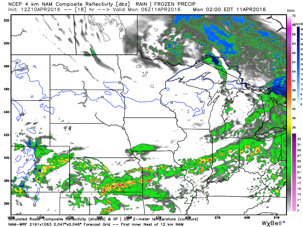
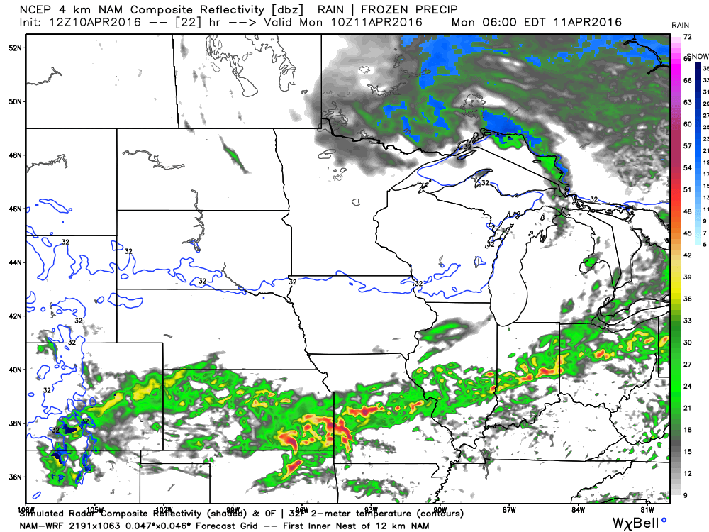
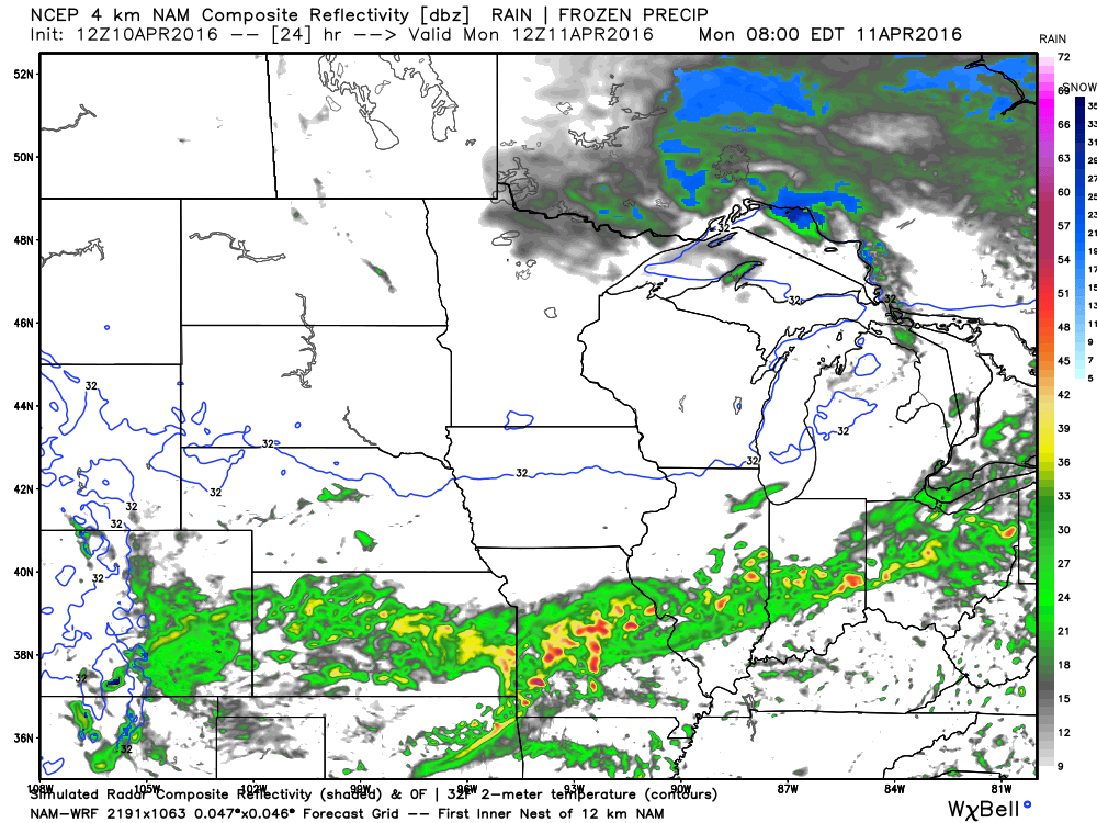
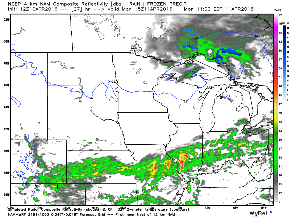
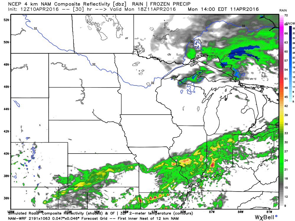
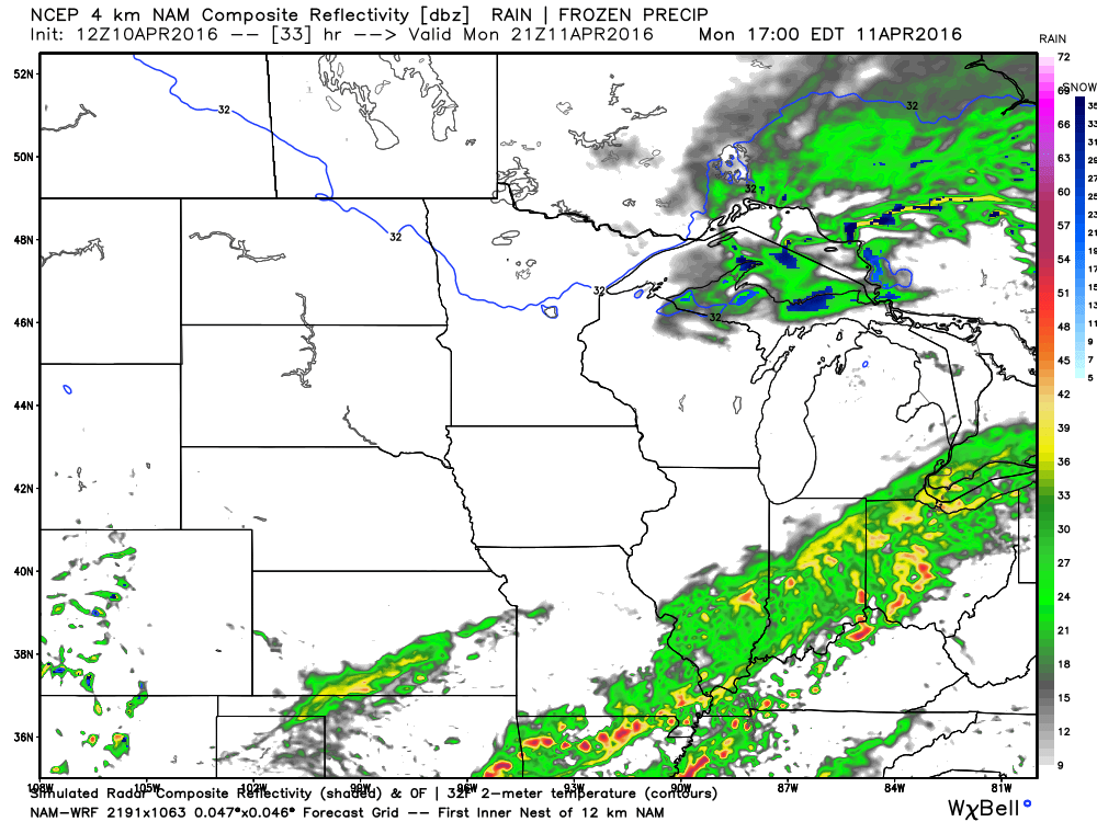
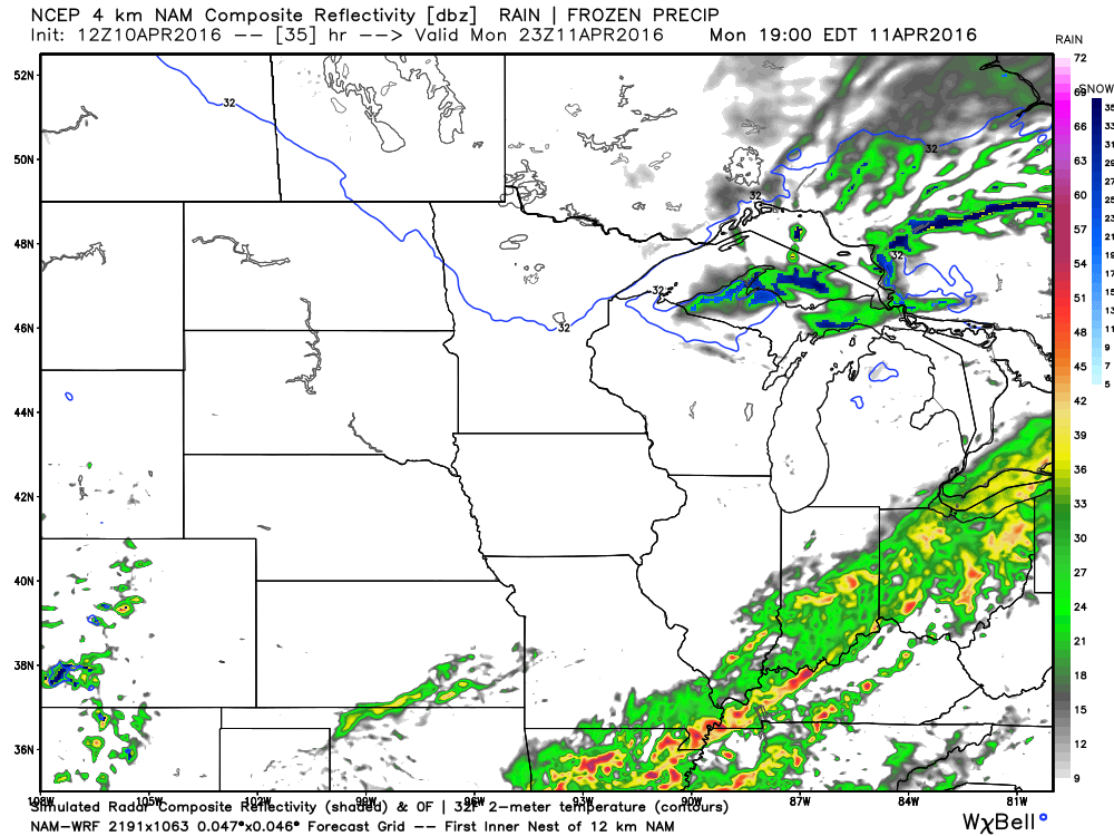
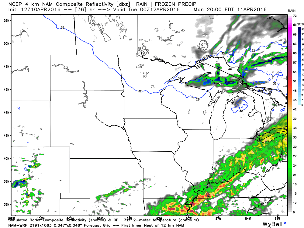
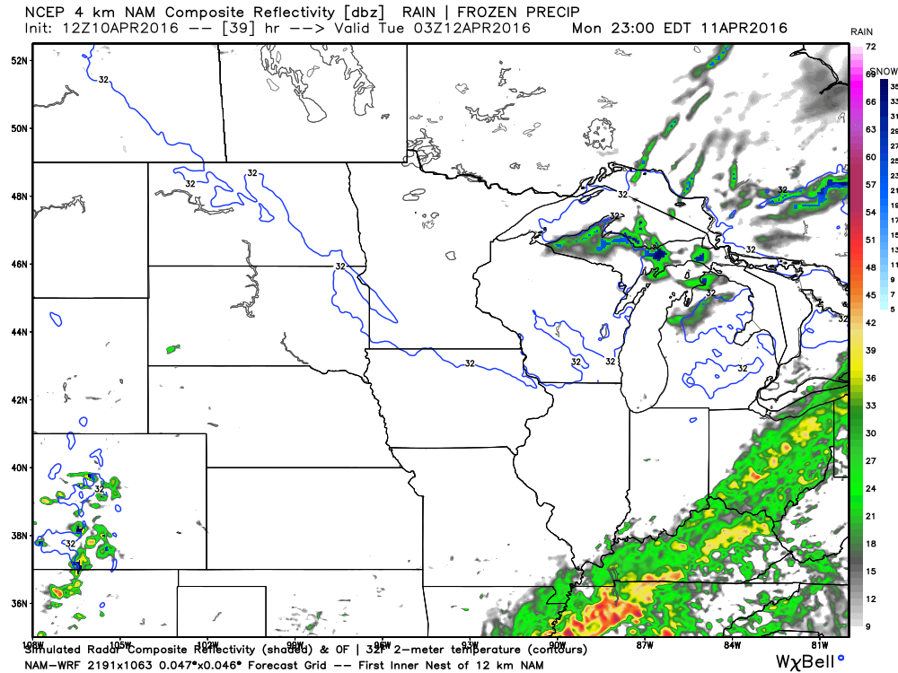
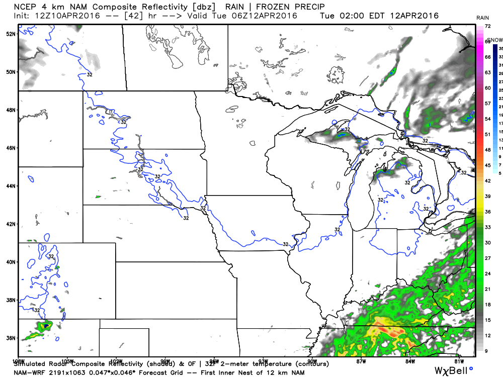
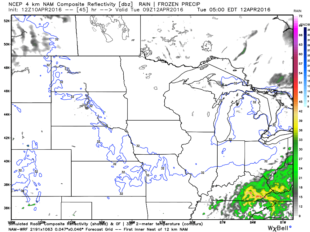
Let’s look at some future-cast radar images from weatherbell.com These images from the high resolution WRF data. This is what radar MIGHT look like on Sunday night and Monday.
You can click each image for a larger view. Green represents rain. Yellow and red are some embedded heavier showers. Perhaps rumbles of thunder.
This first image is for 7 pm on Sunday evening
10 pm Sunday evening
1 am on Monday morning
5 am on Monday morning
7 am on Monday morning
10 am on Monday
1 pm on Monday
4 pm on Monday
6 pm on Monday
7 pm on Monday
10 pm on Monday night
1 am on Tuesday morning
4 am on Tuesday morning
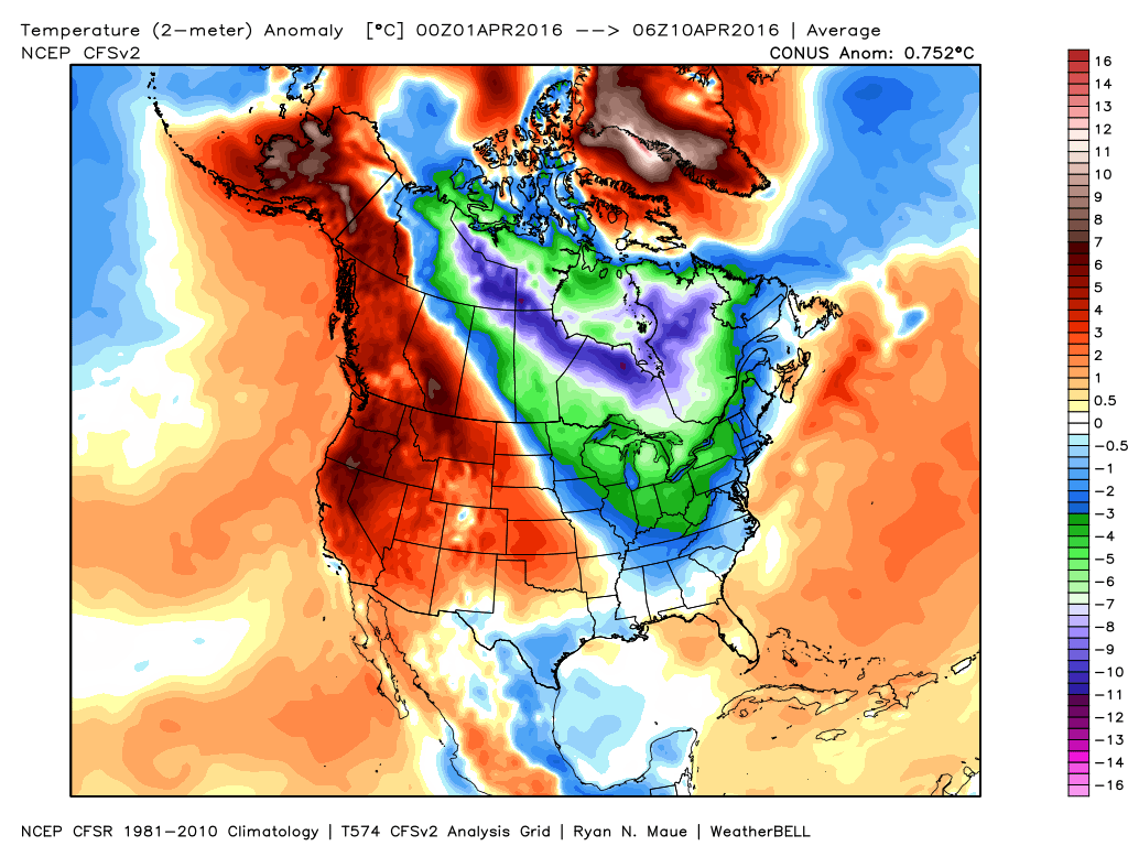
Perhaps a nice warmer trend next Thursday through Sunday. We can hope. Temperatures this month have been well below the normal levels.
Speaking of norms. Here is the month to date temperature anomalies. Below normal has been the rule for much of the eastern United States
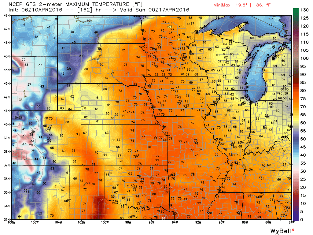
Speaking the warming trend. Here are the forecast high temperatures for Friday and Saturday. Expect some 60s and 70s.
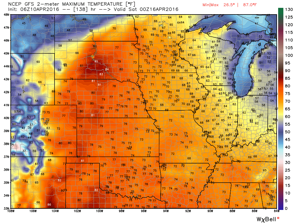
Saturday (image below)
I want to let everyone know the following:
NOTICE on Credit Card statements for WeatherTalk. A number of cards were NOT charged in February and March. Your statement will say pending. You were never charged. Today all of the cards finally processed.
You were only charged once. Even though the “PENDING” charge would have shown up on previous statements. It was never processed.
Today it was processed.
If you signed up for monthly then it is possible you will see February, March, and April’s charges on this months statement. But, again you were never charged previously.
There was an error card in the batches and it caused all transactions on three separate days (in February and March) to be kicked out of the system. Thus, you were never charged.
I have had a couple of people ask me about this. Thinking they were charged multiple times. The only people who would see multiple charges are the ones with a monthly billing plan.
Anyone who paid up front for an entire year was only charged once. Again, you might see pending on previous statements. But, pending means you were not charged.
If you have any concerns then private message me.
Thank you and sorry for any confusion or inconvenience.
Beau

Can we expect severe thunderstorms over the next 24 to 48 hours? Remember that a severe thunderstorm is defined as a thunderstorm that produces 58 mph winds or higher, quarter size hail or larger, and/or a tornado.
.
Sunday Night – A few storms on Sunday night over our far northern counties. Most likely from Farmington northward. Mt Vernon and northward. The storms might end up mostly north of my forecast counties. Any storms that form on Sunday night could produce gusty winds, heavy downpours, and even some hail reports. Again, mostly to the north of my forecast area.
Monday – Thunderstorms are possible. Not anticipating severe weather.
Tuesday – Severe weather is not anticipated.
Wednesday – Severe weather is not anticipated.
Thursday – Severe weather is not anticipated.
Friday – Severe weather is not anticipated.
Saturday – Severe weather is not anticipated.
Sunday – Severe weather is not anticipated
Monday – Severe weather is not anticipated
Tuesday – Severe weather is not anticipated
Wednesday – Severe weather is not anticipated
.
.

.
No major changes in this update.
.
.
Monday night – No concerns
Tuesday night – Monitor updates
Wednesday night – Monitor updates
Thunderstorms are possible on Sunday night and Monday. Lightning is the main concern. Small risk for severe weather. The main area of storms on Sunday night will be just a tad to our north. Closer to St Louis. Some of those storms may creep southward late Sunday night and early Monday morning.


How much precipitation should we expect over the next few days?
Showers are likely as we push into Sunday night and Monday. Precipitation will push in from the west and north. It is possible that early Monday morning will be mostly dry over far southern Illinois and western Kentucky. Increasing rain chances through the day.
A few thunderstorms will also be possible.
Rainfall totals of 0.30″-0.60″ appear likely. And, pockets of higher totals possible. Note the split on this rainfall forecast map. Much of the heavier band to our north will fall on Sunday night and early Monday morning. That band will contain some heavy thunderstorms on Sunday night.
.

Here are the current river stage forecasts. You can click your state and then the dot for your location. It will bring up the full forecast and hydrograph.
.
.

Here is the official 6-10 day and 8-14 day temperature and precipitation outlook. Check the date stamp at the top of each image (so you understand the time frame).
The forecast maps below are issued by the Weather Prediction Center (NOAA).


The latest 8-14 day temperature and precipitation outlook. Note the dates are at the top of the image. These maps DO NOT tell you how high or low temperatures or precipitation will be. They simply give you the probability as to whether temperatures or precipitation will be above or below normal.


Who do you trust for your weather information and who holds them accountable?
I have studied weather in our region since the late 1970’s. I have 37 years of experience in observing our regions weather patterns. My degree is in Broadcast Meteorology from Mississippi State University and an Associate of Science (AS). I am currently working on my Bachelor’s Degree in Geoscience.
My resume includes:
Member of the American Meteorological Society.
NOAA Weather-Ready Nation Ambassador.
Meteorologist for McCracken County Emergency Management. I served from 2005 through 2015.
I own and operate the Southern Illinois Weather Observatory.
Recipient of the Mark Trail Award, WPSD Six Who Make A Difference Award, Kentucky Colonel, and the Caesar J. Fiamma” Award from the American Red Cross.
In 2009 I was presented with the Kentucky Office of Highway Safety Award.
Recognized by the Kentucky House of Representatives for my service to the State of Kentucky leading up to several winter storms and severe weather outbreaks.
I am also President of the Shadow Angel Foundation which serves portions of western Kentucky and southern Illinois.
There is a lot of noise on the internet. A lot of weather maps are posted without explanation. Over time you should learn who to trust for your weather information.
My forecast philosophy is simple and straight forward.
- Communicate in simple terms
- To be as accurate as possible within a reasonable time frame before an event
- Interact with you on Twitter, Facebook, and the blog
- Minimize the “hype” that you might see on television or through other weather sources
- Push you towards utilizing wall-to-wall LOCAL TV coverage during severe weather events
I am a recipient of the Mark Trail Award, WPSD Six Who Make A Difference Award, Kentucky Colonel, and the Caesar J. Fiamma” Award from the American Red Cross. In 2009 I was presented with the Kentucky Office of Highway Safety Award. I was recognized by the Kentucky House of Representatives for my service to the State of Kentucky leading up to several winter storms and severe weather outbreaks.
If you click on the image below you can read the Kentucky House of Representatives Resolution.

Many of my graphics are from www.weatherbell.com – a great resource for weather data, model data, and more


You can sign up for my AWARE email by clicking here I typically send out AWARE emails before severe weather, winter storms, or other active weather situations. I do not email watches or warnings. The emails are a basic “heads up” concerning incoming weather conditions.