
Click one of the links below to take you directly to that section
![]()
![]()
![]()
![]()
![]()
![]()
![]()
.

.
Seven Day Hazardous Weather Outlook
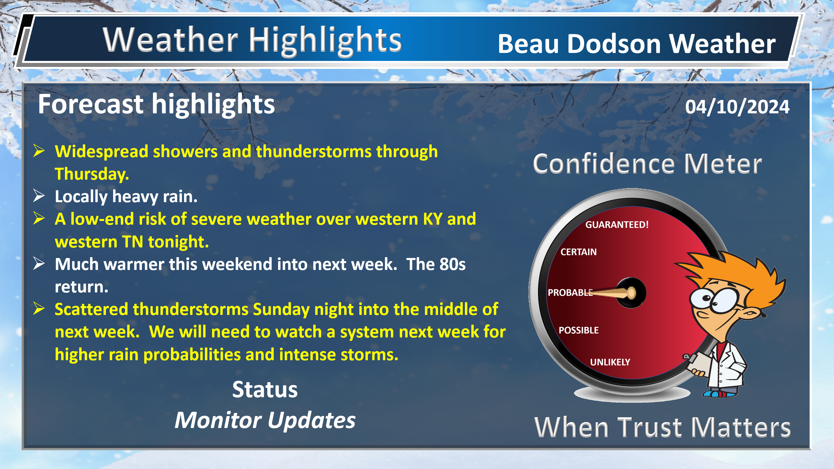
1. Is lightning in the forecast? YES. Lightning is likely today into Thursday. Another chance of lightning Sunday night into at least Tuesday night.
2. Are severe thunderstorms in the forecast? MONITOR. A few storms could become severe tonight over western Kentucky and western Tennessee. Overall, the risk appears very low. If a storm became surface based it could tap into some very strong wind shear. The atmosphere will be rotating. It appears instability will be limited, thus the risk is very low. Monitor updates.
I am monitoring thunderstorm chances Sunday night into the middle of next week. Some of those could be strong.
3. Is flash flooding in the forecast? POSSIBLE. Locally heavy rain is likely into Thursday. Some ponding of water in fields and ditches will occur. Void flooded roadways.
4. Will non-thunderstorm winds top 40 mph? POSSIBLE. Winds will approach 40 mph Thursday and Friday. A wind advisory may be necessary.
5. Will the heat index exceed 100 degrees? NO.
6. Will the wind chill dip below 10 degrees? NO.
7. Is measurable snow and/or sleet in the forecast? NO.
8. Is freezing rain/ice in the forecast? NO.
Freezing rain is rain that falls and instantly freezes on objects such as trees and power lines Freezing fog possible, as well.
.

Fire weather risk level.
Wednesday through Wednesday night: 3. Very low risk.
Thursday: 3. Very low risk.
Thursday night: 4. Low risk.
Fire Weather Discussion
Widespread showers and scattered thunderstorms will bring 1-3″ of rainfall to the region through Thursday. As the rains end from the west Thursday, very gusty northwest winds will develop. The gusty northwest winds will continue into Friday, as very deep and strong mixing develops and minimum relative humidity drops to 25-30%. Southwest winds will become gusty Saturday with similar relative humidity. Gusty south to southwest winds will be the rule through the first half of next week, along with warm temperatures and increasing humidity.
A Haines Index of 6 means a high potential for an existing fire to become large or exhibit erratic fire behavior, 5 means medium potential, 4 means low potential, and anything less than 4 means very low potential.
.

THE FORECAST IS GOING TO VARY FROM LOCATION TO LOCATION.
Scroll down to see your local forecast details.
Seven-day forecast for southeast Missouri, southern Illinois, western Kentucky, and western Tennessee.
This is a BLEND for the region. Scroll down to see the region by region forecast.

48-hour forecast Graphics


.
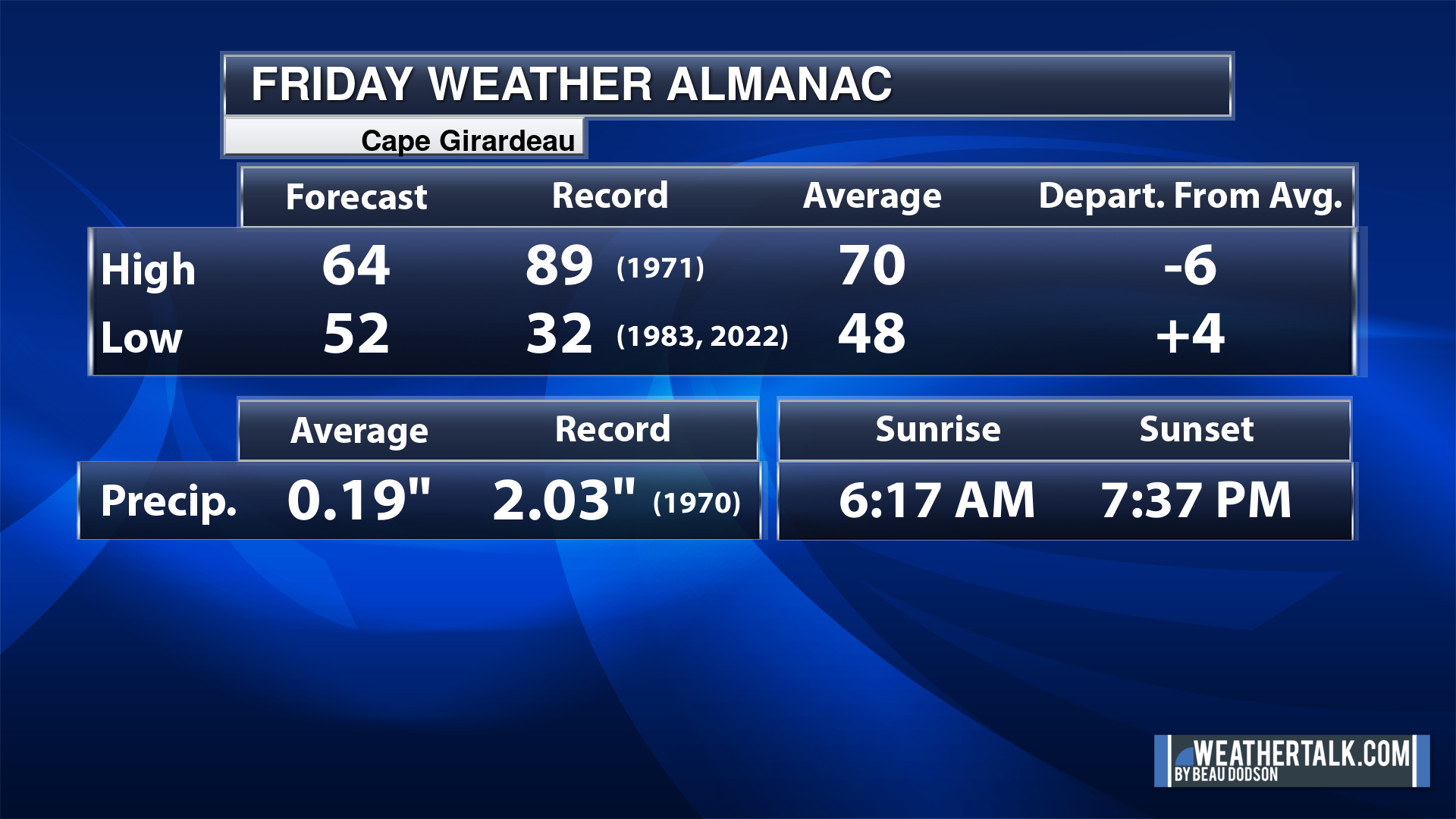
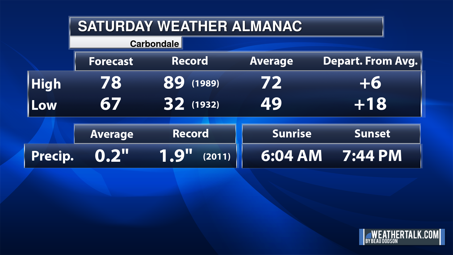
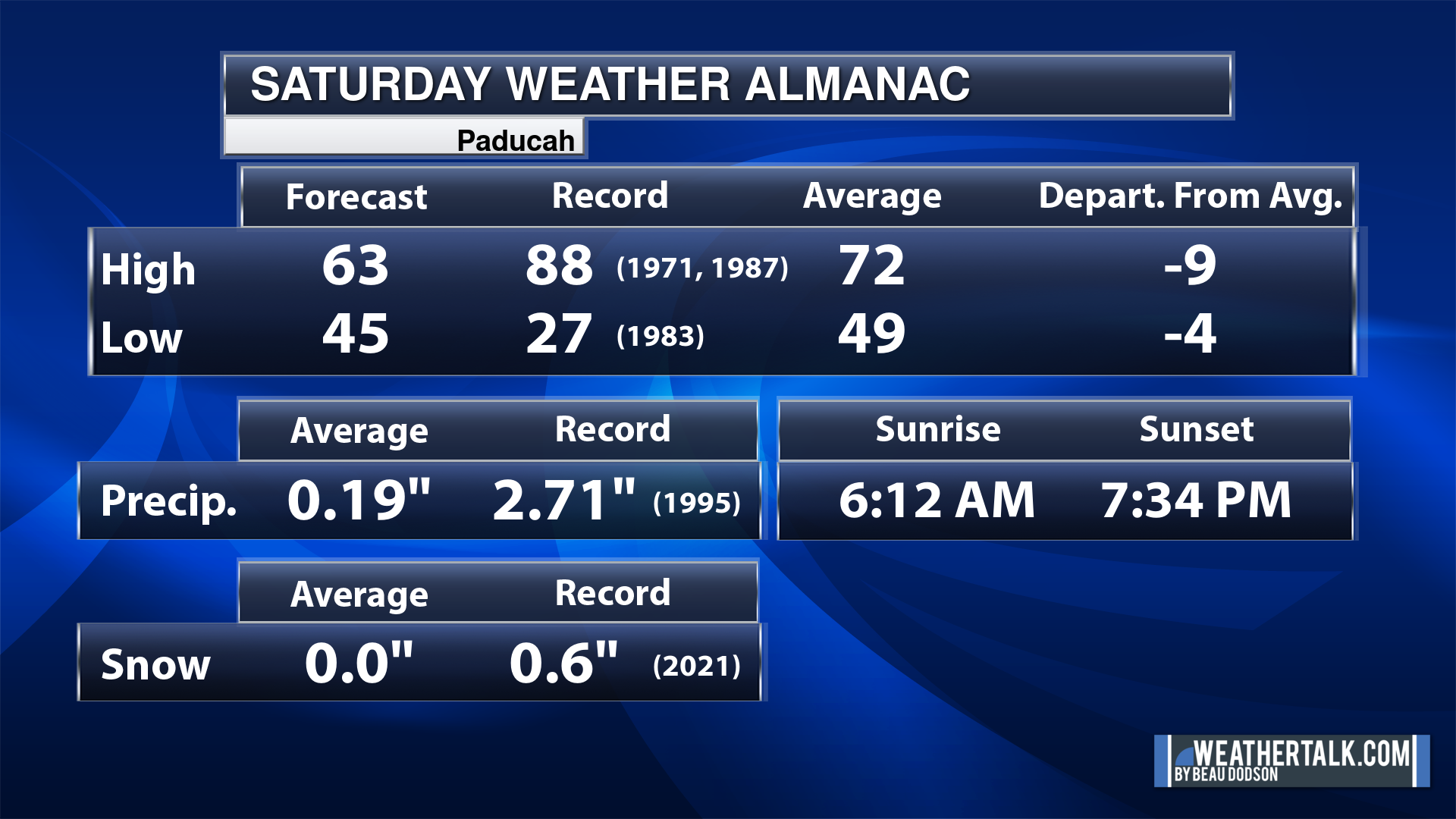
Today’s Local Almanacs (for a few select cities). Your location will be comparable.
Note, the low is this morning’s low and not tomorrows.
The forecast temperature shows you today’s expected high and this morning’s low.
The graphic shows you the record high and record low for today. It shows you what year that occurred, as well.
It then shows you what today’s average temperature is.
It shows you the departures (how may degrees above or below average temperatures will be ).
It shows you the average precipitation for today. Average comes from thirty years of rain totals.
It also shows you the record rainfall for the date and what year that occurred.
The sunrise and sunset are also shown.


![]()
.
.
Wednesday Forecast: Showers and thunderstorms likely. We will need to monitor the track of the area of low pressure. Where it tracks, the rain totals will be lower. Heavier rain to the northwest of the low.
What is the chance of precipitation?
Far northern southeast Missouri ~ 90%
Southeast Missouri ~ 90%
The Missouri Bootheel ~ 90%
I-64 Corridor of southern Illinois ~ 80%
Southern Illinois ~ 80%
Extreme southern Illinois (southern seven counties) ~ 80%
Far western Kentucky (Purchase area) ~ 80%
The Pennyrile area of western KY ~ 80%
Northwest Kentucky (near Indiana border) ~ 80%
Northwest Tennessee ~ 90%
Coverage of precipitation: Numerous.
Timing of the precipitation: Any given point of time.
Far northern southeast Missouri ~ 66° to 70°
Southeast Missouri ~ 66° to 70°
The Missouri Bootheel ~ 66° to 70°
I-64 Corridor of southern Illinois ~ 66° to 70°
Southern Illinois ~ 66° to 70°
Extreme southern Illinois (southern seven counties) ~ 66° to 70°
Far western Kentucky ~ 66° to 70°
The Pennyrile area of western KY ~ 66° to 70°
Northwest Kentucky (near Indiana border) ~ 66° to 70°
Northwest Tennessee ~ 66° to 70°
Winds will be from this direction: East southeast 10 t0 25 mph
Wind chill or heat index (feels like) temperature forecast: 66° to 70°
What impacts are anticipated from the weather? Wet roadways. Lightning.
Should I cancel my outdoor plans? Have a plan B and monitor the Beau Dodson Weather Radars
UV Index: 3. Moderate.
Sunrise: 6:27 AM
Sunset: 7:26 PM
.
Wednesday Night Forecast: Showers and thunderstorms likely. We will need to monitor the track of the area of low pressure. Where it tracks, the rain totals will be lower. Heavier rain to the northwest of the low. Some storms could be intense over Kentucky and Tennessee.
What is the chance of precipitation?
Far northern southeast Missouri ~ 90%
Southeast Missouri ~ 90%
The Missouri Bootheel ~ 90%
I-64 Corridor of southern Illinois ~ 80%
Southern Illinois ~ 80%
Extreme southern Illinois (southern seven counties) ~ 80%
Far western Kentucky (Purchase area) ~ 80%
The Pennyrile area of western KY ~ 90%
Northwest Kentucky (near Indiana border) ~ 90%
Northwest Tennessee ~ 90%
Coverage of precipitation: Numerous.
Timing of the precipitation: Any given point of time.
Temperature range:
Far northern southeast Missouri ~ 48° to 52°
Southeast Missouri ~ 48° to 52°
The Missouri Bootheel ~ 48° to 52°
I-64 Corridor of southern Illinois ~ 48° to 52°
Southern Illinois ~ 48° to 52°
Extreme southern Illinois (southern seven counties) ~ 48° to 52°
Far western Kentucky ~ 48° to 52°
The Pennyrile area of western KY ~ 50° to 55°
Northwest Kentucky (near Indiana border) ~ 48° to 52°
Northwest Tennessee ~ 50° to 54°
Winds will be from this direction: Southeast becoming north northwest 15 to 30 mph
Wind chill or heat index (feels like) temperature forecast: 48° to 52°
What impacts are anticipated from the weather? Wet roadways. Lightning.
Should I cancel my outdoor plans? Have a plan B and monitor the Beau Dodson Weather Radars
Moonrise: 7:26 AM
Moonset: 10:11 PM
The phase of the moon: Waxing Crescent
.
Thursday Forecast: Showers and thunderstorms likely. Rain ending with time from west to east.
What is the chance of precipitation?
Far northern southeast Missouri ~ 80%
Southeast Missouri ~ 90%
The Missouri Bootheel ~ 90%
I-64 Corridor of southern Illinois ~ 80%
Southern Illinois ~ 80%
Extreme southern Illinois (southern seven counties) ~ 80%
Far western Kentucky (Purchase area) ~ 90%
The Pennyrile area of western KY ~ 80%
Northwest Kentucky (near Indiana border) ~ 80%
Northwest Tennessee ~ 90%
Coverage of precipitation: Numerous.
Timing of the precipitation: Any given point of time.
Far northern southeast Missouri ~ 62° to 65°
Southeast Missouri ~ 62° to 65°
The Missouri Bootheel ~ 62° to 65°
I-64 Corridor of southern Illinois ~ 62° to 65°
Southern Illinois ~ 62° to 65°
Extreme southern Illinois (southern seven counties) ~ 62° to 65°
Far western Kentucky ~ 62° to 65°
The Pennyrile area of western KY ~ 62° to 65°
Northwest Kentucky (near Indiana border) ~ 62° to 65°
Northwest Tennessee ~ 62° to 65°
Winds will be from this direction: Northwest 20 to 40 mph
Wind chill or heat index (feels like) temperature forecast: 62° to 65°
What impacts are anticipated from the weather? Wet roadways. Lightning.
Should I cancel my outdoor plans? Have a plan B and monitor the Beau Dodson Weather Radars
UV Index: 5. Moderate.
Sunrise: 6:26 AM
Sunset: 7:27 PM
.
Thursday Night Forecast: Any remaining showers and thunderstorms will end west to east. Some clearing overnight.
What is the chance of precipitation?
Far northern southeast Missouri ~ 30%
Southeast Missouri ~ 30%
The Missouri Bootheel ~ 30%
I-64 Corridor of southern Illinois ~ 40%
Southern Illinois ~ 40%
Extreme southern Illinois (southern seven counties) ~ 40%
Far western Kentucky (Purchase area) ~ 40%
The Pennyrile area of western KY ~ 40%
Northwest Kentucky (near Indiana border) ~ 40%
Northwest Tennessee ~ 40%
Coverage of precipitation: Scattered. Ending.
Timing of the precipitation: Ending
Temperature range:
Far northern southeast Missouri ~ 42° to 45°
Southeast Missouri ~ 42° to 45°
The Missouri Bootheel ~ 42° to 45°
I-64 Corridor of southern Illinois ~ 42° to 45°
Southern Illinois ~ 42° to 45°
Extreme southern Illinois (southern seven counties) ~ 42° to 45°
Far western Kentucky ~ 44° to 48°
The Pennyrile area of western KY ~ 44° to 48°
Northwest Kentucky (near Indiana border) ~ 44° to 46°
Northwest Tennessee ~ 44° to 48°
Winds will be from this direction: Northwest 10 to 25 mph. Gusty.
Wind chill or heat index (feels like) temperature forecast: 34° to 46°
What impacts are anticipated from the weather? Wet roadways. Lightning.
Should I cancel my outdoor plans? No, but monitor the Beau Dodson Weather Radars
Moonrise: 8:05 AM
Moonset: 11:24 PM
The phase of the moon: Waxing Crescent
.
Friday Forecast: Mostly sunny.
What is the chance of precipitation?
Far northern southeast Missouri ~ 0%
Southeast Missouri ~ 0%
The Missouri Bootheel ~ 0%
I-64 Corridor of southern Illinois ~ 0%
Southern Illinois ~ 0%
Extreme southern Illinois (southern seven counties) ~ 0%
Far western Kentucky (Purchase area) ~ 0%
The Pennyrile area of western KY ~ 0%
Northwest Kentucky (near Indiana border) ~ 0%
Northwest Tennessee ~ 0%
Coverage of precipitation:
Timing of the precipitation:
Far northern southeast Missouri ~ 65° to 70°
Southeast Missouri ~ 65° to 70°
The Missouri Bootheel ~ 65° to 70°
I-64 Corridor of southern Illinois ~ 65° to 70°
Southern Illinois ~ 65° to 70°
Extreme southern Illinois (southern seven counties) ~ 65° to 70°
Far western Kentucky ~ 65° to 70°
The Pennyrile area of western KY ~ 65° to 70°
Northwest Kentucky (near Indiana border) ~ 65° to 70°
Northwest Tennessee ~ 65° to 70°
Winds will be from this direction: West northwest 15 to 35 mph
Wind chill or heat index (feels like) temperature forecast: 65° to 70°
What impacts are anticipated from the weather?
Should I cancel my outdoor plans? No
UV Index: 7. High
Sunrise: 6:24 AM
Sunset: 7:28 PM
.
Friday Night Forecast: Mostly clear.
What is the chance of precipitation?
Far northern southeast Missouri ~ 0%
Southeast Missouri ~ 0%
The Missouri Bootheel ~ 0%
I-64 Corridor of southern Illinois ~ 0%
Southern Illinois ~ 0%
Extreme southern Illinois (southern seven counties) ~ 0%
Far western Kentucky (Purchase area) ~ 0%
The Pennyrile area of western KY ~ 0%
Northwest Kentucky (near Indiana border) ~ 0%
Northwest Tennessee ~ 0%
Coverage of precipitation:
Timing of the precipitation:
Temperature range:
Far northern southeast Missouri ~ 43° to 46°
Southeast Missouri ~ 42° to 45°
The Missouri Bootheel ~ 42° to 45°
I-64 Corridor of southern Illinois ~ 43° to 46°
Southern Illinois ~ 42° to 45°
Extreme southern Illinois (southern seven counties) ~ 42° to 45°
Far western Kentucky ~ 42° to 45°
The Pennyrile area of western KY ~ 42° to 45°
Northwest Kentucky (near Indiana border) ~ 42° to 45°
Northwest Tennessee ~ 42° to 45°
Winds will be from this direction: West southwest 10 to 25 mph. Gusty.
Wind chill or heat index (feels like) temperature forecast: 36° to 42°
What impacts are anticipated from the weather?
Should I cancel my outdoor plans? No
Moonrise: 8:50 AM
Moonset:
The phase of the moon: Waxing Crescent
.
Click here if you would like to return to the top of the page.

-
- Showers and thunderstorms on and off into Thursday evening.
- We will need to watch the dry slow. That is where rain totals will be lower.
- Locally heavy rain.
- Gusty winds this week, as well.
- Monitoring the risk of severe weather Wednesday night. Low risk.
- Dry Friday into Saturday.
Weather advice:
Do you have any suggestions or comments? Email me at beaudodson@usawx.com
Make sure you have three to five ways of receiving your severe weather information.
Weather Talk is one of those ways.
.
Beau’s Forecast Discussion
Good day, everyone.
Well, our much anticipated rain has arrived. Some areas have already received more than an inch of rain. Another widespread 0.7 to 1.4″ is anticipated with pockets of greater than two inches.
Here is the latest rainfall outlook
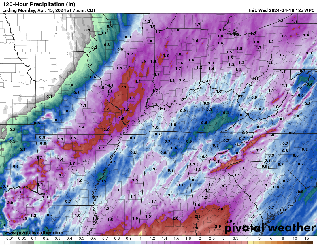
Yesterday, I mentioned a dry slot would cut totals over portions of the region. That appears most likely across portions of Kentucky/Tennessee.
Notice how the totals are higher over Arkansas, Missouri, and Illinois. That is because they are to the left of the area of low pressure.
The dry slot cuts totals down.
We will have showers and thunderstorms on radar today into Thursday afternoon. It won’t rain everywhere the entire time, but scattered on and off rain.
Rain will become more numerous this afternoon and evening. Coverage will increase. Intensity of the rain will increase.
This will occur as the area of low pressure deepens over the central United States.
Thankfully, our region is not in the highest risk of severe thunderstorms. The risk is higher well to our south where a severe weather outbreak may occur.
Our region is on the north side of the severe weather threat zone. Officially, the Storm Prediction Center has outlined portions of Kentucky and Tennessee for the threat of a few severe thunderstorms tonight. Wednesday night.
The threat would be short lived tornadoes, hail, and wind.
There is quite a bit of wind shear in the atmosphere. Wind shear is the turning of wind direction and speed with height. Rotation.
We just aren’t going to have much instability to work with. That should help keep the severe weather threat limited. If any at all. I will monitor the situation tonight.
Overall, the threat is low. But, not zero.
Showers and thunderstorms will continue into Thursday. Some tapering of the rain will occur Thursday afternoon and come to an end Thursday night.
It will be windy over the coming days. Peak wind will be Thursday and Friday. This is when winds could top 40 mph. The NWS said they may issue a wind advisory. Either way, gusty winds into Friday afternoon.
A strong warming trends begins Saturday, Sunday, Monday, and Tuesday. As a matter of fact, some areas could reach into the 80s later this weekend and next week!
A few thunderstorms will return to the forecast Sunday night into Wednesday. Into at least Wednesday. It is possible thunderstorm chances continue beyond that.
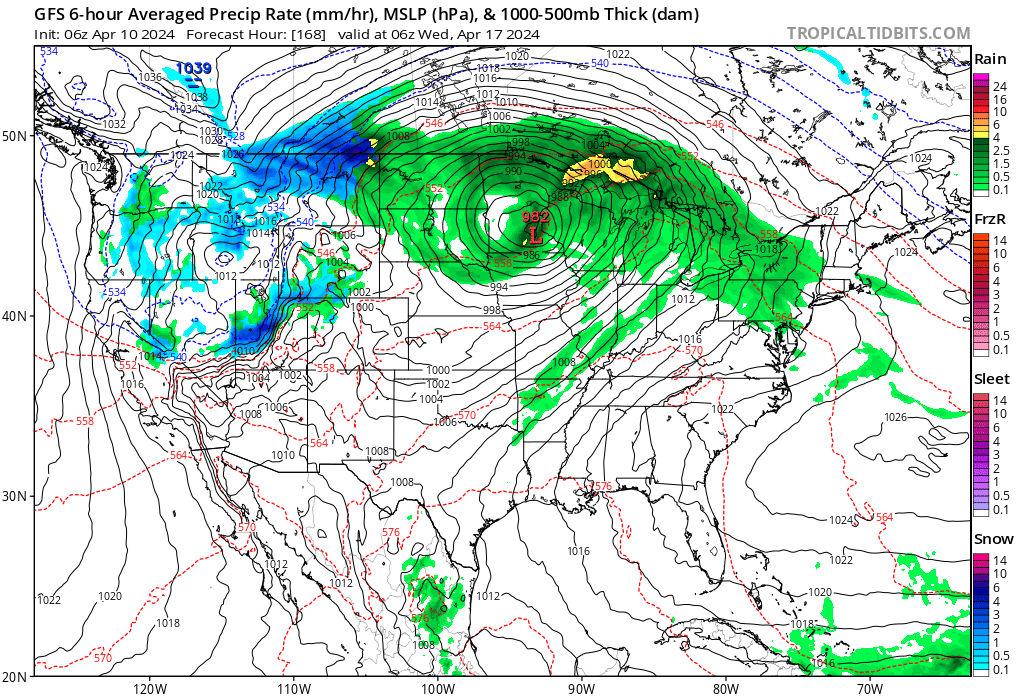
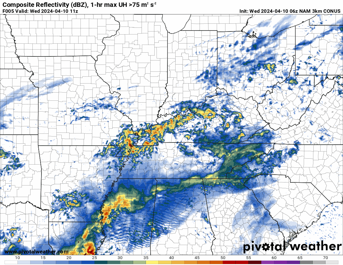
I will be watching a larger storm system around Tuesday and Wednesday of next week. Rain chances will increase a bit with that.
You can see that on this GFS weather map. This is for next Tuesday night. That is a deep low Over Iowa and Minnesota with a cold front extending southward from it. Showers and thunderstorms will occur along that front. Some could be intense. Long way off and plenty of time to watch that system.
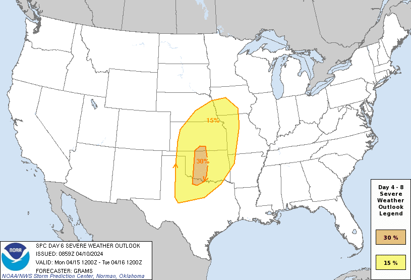
The Storm Prediction Center has already outlined a severe weather threat Monday to our west. That could spread eastward by Tuesday.
This is the Monday severe weather outlook. The cold front, with time, will sweep eastward.
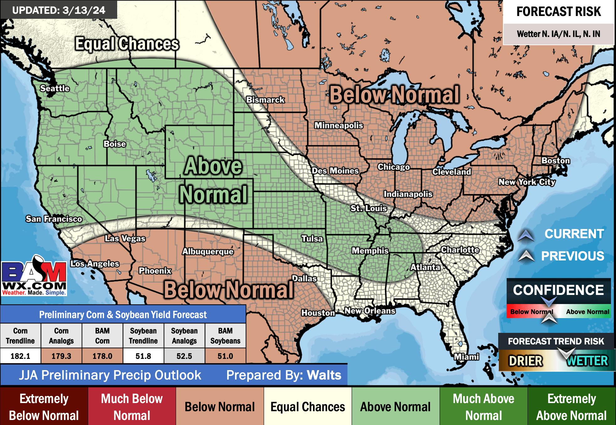
Let’s look at some long range outlooks from the long range team.
April 23rd through May 6th

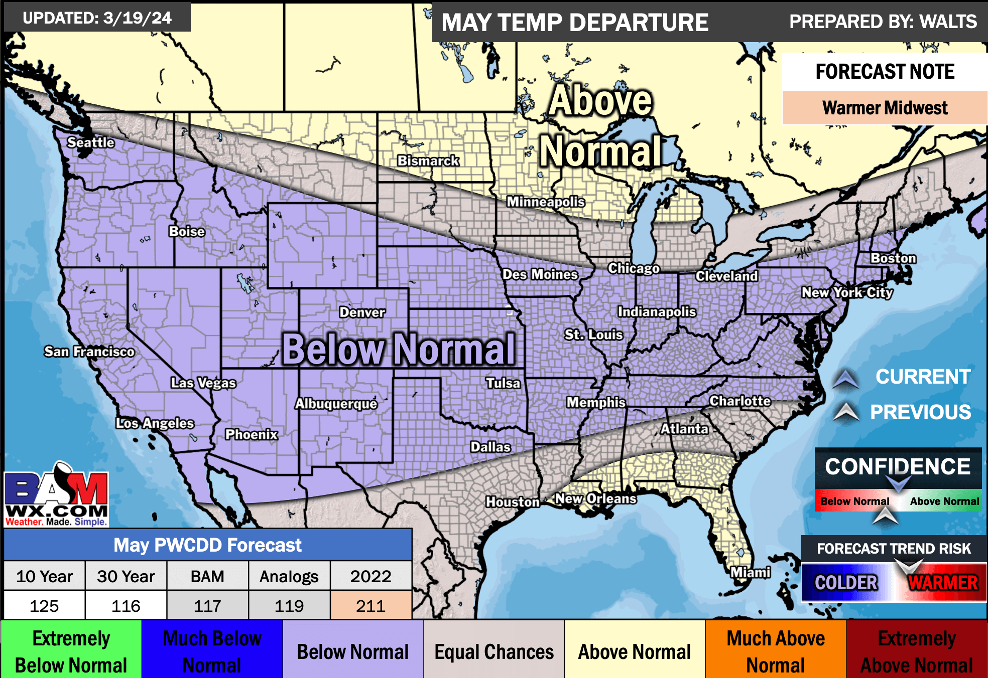
May Temperature Outlook
May Precipitation Outlook

June Temperature Outlook

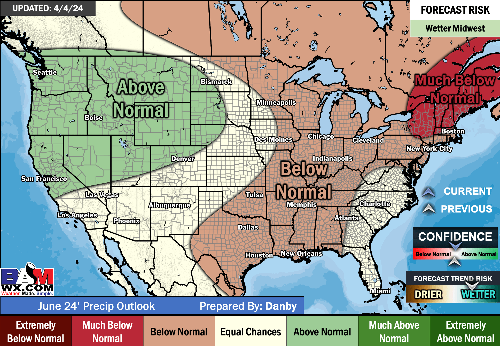
June Precipitation Outlook
July Temperature Outlook

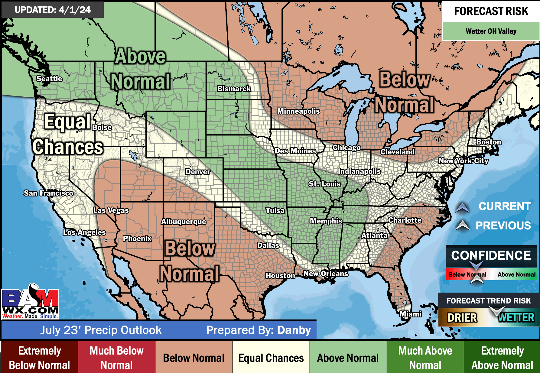
July Precipitation Outlook
August Temperature Outlook


June, July, and August Preliminary Temperature Outlook

June, July, and August Preliminary Precipitation Outlook
![]()
.
Click here if you would like to return to the top of the page.
This outlook covers southeast Missouri, southern Illinois, western Kentucky, and far northwest Tennessee.

.
Today’s Storm Prediction Center’s (SPC) Severe Weather Outlook
Light green is where thunderstorms may occur but should be below severe levels.
Dark green is a level one risk. Yellow is a level two risk. Orange is a level three (enhanced) risk. Red is a level four (moderate) risk. Pink is a level five (high) risk.
One is the lowest risk. Five is the highest risk.
A severe storm is one that produces 58 mph wind or higher, quarter or larger size hail, and/or a tornado.
Explanation of tables. Click here.
Day One Severe Weather Outlook

Day One Severe Weather Outlook. Zoomed in on our region.

.
Day One Tornado Probability Outlook

Day One Regional Tornado Outlook. Zoomed in on our region.

.
Day One Large Hail Probability Outlook

Day One Regional Hail Outlook. Zoomed in on our region.

.
Day One High wind Probability Outlook

Day One Regional Wind Outlook. Zoomed in on our region.

.
Tomorrow’s severe weather outlook. Day two outlook.

Day Two Outlook. Zoomed in on our region.

.
Day Three Severe Weather Outlook

.

.
The images below are from NOAA’s Weather Prediction Center.
24-hour precipitation outlook..
 .
.
.
48-hour precipitation outlook.
. .
.
![]()
_______________________________________
.

Click here if you would like to return to the top of the page.
Again, as a reminder, these are models. They are never 100% accurate. Take the general idea from them.
What should I take from these?
- The general idea and not specifics. Models usually do well with the generalities.
- The time-stamp is located in the upper left corner.
.
What am I looking at?
You are looking at computer model data. Meteorologists use many different models to forecast the weather.
Occasionally, these maps are in Zulu time. 12z=7 AM. 18z=1 PM. 00z=7 PM. 06z=1 AM
Green represents light rain. Dark green represents moderate rain. Yellow and orange represent heavier rain.
.
This animation is the NAM 3K Model.
Occasionally, these maps are in Zulu time. 12z=7 AM. 18z=1 PM. 00z=7 PM. 06z=1 AM
Double click images to enlarge them.
.
This animation is the HRRR Model.
Green is rain. Yellow and orange are heavier rain. Pink is a wintry mix. Blue is snow. Dark blue is heavier snow.
Occasionally, these maps are in Zulu time. 12z=7 AM. 18z=1 PM. 00z=7 PM. 06z=1 AM
Double click images to enlarge them.

.
This animation is the FVS Model.
Green is rain. Yellow and orange are heavier rain. Pink is a wintry mix. Blue is snow. Dark blue is heavier snow.
Occasionally, these maps are in Zulu time. 12z=7 AM. 18z=1 PM. 00z=7 PM. 06z=1 AM
Double click images to enlarge them.
.
This animation is the GFS Model.
Green is rain. Yellow and orange are heavier rain. Pink is a wintry mix. Blue is snow. Dark blue is heavier snow.
Occasionally, these maps are in Zulu time. 12z=7 AM. 18z=1 PM. 00z=7 PM. 06z=1 AM
Double click images to enlarge them.

.
This animation is the EC Model.
Green is rain. Yellow and orange are heavier rain. Pink is a wintry mix. Blue is snow. Dark blue is heavier snow.
Occasionally, these maps are in Zulu time. 12z=7 AM. 18z=1 PM. 00z=7 PM. 06z=1 AM
Double click images to enlarge them.
.
..![]()

.
Click here if you would like to return to the top of the page.
.Average high temperatures for this time of the year are around 66 degrees.
Average low temperatures for this time of the year are around 44 degrees.
Average precipitation during this time period ranges from 0.80″ to 1.60″
Six to Ten Day Outlook.
Blue is below average. Red is above average. The no color zone represents equal chances.
Average highs for this time of the year are in the lower 60s. Average lows for this time of the year are in the lower 40s.

Green is above average precipitation. Yellow and brown favors below average precipitation. Average precipitation for this time of the year is around one inch per week.

.

Average low temperatures for this time of the year are around 45 degrees.
Average precipitation during this time period ranges from 0.80″ to 1.60″
.
Eight to Fourteen Day Outlook.
Blue is below average. Red is above average. The no color zone represents equal chances.

Green is above average precipitation. Yellow and brown favors below average precipitation. Average precipitation for this time of the year is around one inch per week.

.
![]()
The app is for subscribers. Subscribe at www.weathertalk.com/welcome then go to your app store and search for WeatherTalk
Subscribers, PLEASE USE THE APP. ATT and Verizon are not reliable during severe weather. They are delaying text messages.
The app is under WeatherTalk in the app store.

Apple users click here

Android users click here
.

Radars and Lightning Data
Interactive-city-view radars. Clickable watches and warnings.
https://wtalk.co/B3XHASFZ
If the radar is not updating then try another one. If a radar does not appear to be refreshing then hit Ctrl F5. You may also try restarting your browser.
Backup radar site in case the above one is not working.
https://weathertalk.com/morani
Regional Radar
https://imagery.weathertalk.com/prx/RadarLoop.mp4
** NEW ** Zoom radar with chaser tracking abilities!
ZoomRadar
Lightning Data (zoom in and out of your local area)
https://wtalk.co/WJ3SN5UZ
Not working? Email me at beaudodson@usawx.com
National map of weather watches and warnings. Click here.
Storm Prediction Center. Click here.
Weather Prediction Center. Click here.
.

Live lightning data: Click here.
Real time lightning data (another one) https://map.blitzortung.org/#5.02/37.95/-86.99
Our new Zoom radar with storm chases
.
.

Interactive GOES R satellite. Track clouds. Click here.
GOES 16 slider tool. Click here.
College of DuPage satellites. Click here
.

Here are the latest local river stage forecast numbers Click Here.
Here are the latest lake stage forecast numbers for Kentucky Lake and Lake Barkley Click Here.
.
.
Find Beau on Facebook! Click the banner.


 .
.