
Click one of the links below to take you directly to that section
![]()
![]()
![]()
![]()
![]()
![]()
![]()
.

.
Seven Day Hazardous Weather Outlook
1. Is lightning in the forecast? YES. Lightning is possible today into Tuesday. I will monitor next Sunday into Tuesday.
2. Are severe thunderstorms in the forecast? YES. Severe thunderstorms are possible Monday afternoon and night. Some risk on Tuesday morning, as well. We will need to monitor the track of the cold front Tuesday. It is possible that a few storm redevelop during the afternoon hours on Tuesday. Once the cold front exits your county, then the threat of severe weather is over.
3. Is flash flooding in the forecast? MONITOR. Any slow moving thunderstorms could cause locally heavy rain. If a couple of storms train over the same areas, then the risk of flash flooding will increase.
4. Will non-thunderstorm winds top 40 mph? NOT AT THIS TIME. Gusty winds are possible today into Tuesday. For now, I kept them below 40 mph.
5. Will the heat index exceed 100 degrees? NO.
6. Will the wind chill dip below 10 degrees? NO.
7. Is measurable snow and/or sleet in the forecast? NO.
8. Is freezing rain/ice in the forecast? NO.
Freezing rain is rain that falls and instantly freezes on objects such as trees and power lines Freezing fog possible, as well.
.

Fire weather risk level.
Monday through Monday night: 4. Low risk.
Tuesday: 3. Very low risk.
Tuesday night: 4. Very low risk.
Fire Weather Discussion
Today should be mostly dry, with a southwest breeze and mixing heights up to around 3000 ft. This should lead to fair to good smoke dispersion through the day. Thunderstorms will approach tonight into Tuesday followed by a cold front that will sweep much cooler conditions and lower relative humidity values into the area.
A Haines Index of 6 means a high potential for an existing fire to become large or exhibit erratic fire behavior, 5 means medium potential, 4 means low potential, and anything less than 4 means very low potential.
.

THE FORECAST IS GOING TO VARY FROM LOCATION TO LOCATION.
Scroll down to see your local forecast details.
Seven-day forecast for southeast Missouri, southern Illinois, western Kentucky, and western Tennessee.
This is a BLEND for the region. Scroll down to see the region by region forecast.
48-hour forecast Graphics


.
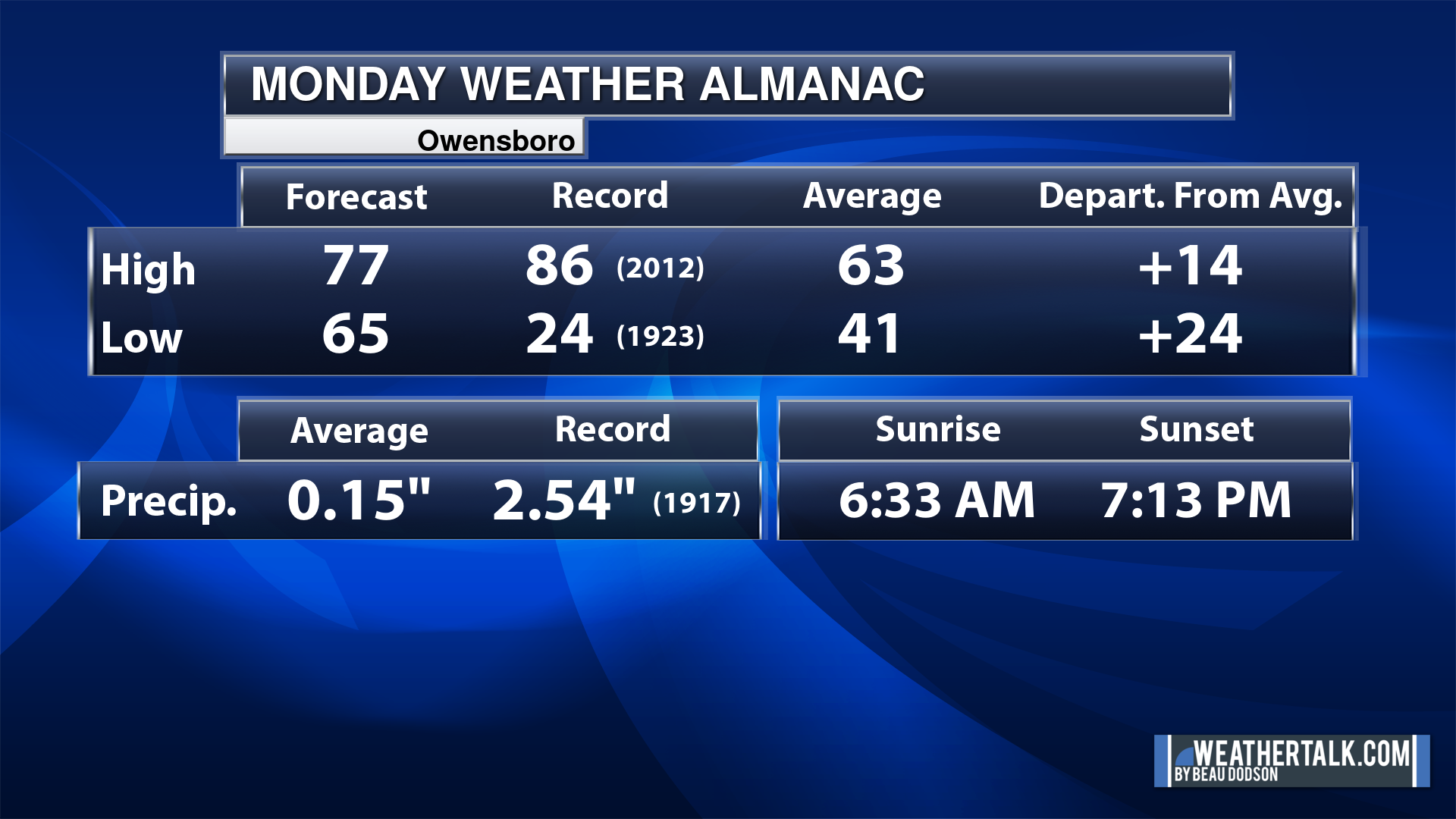
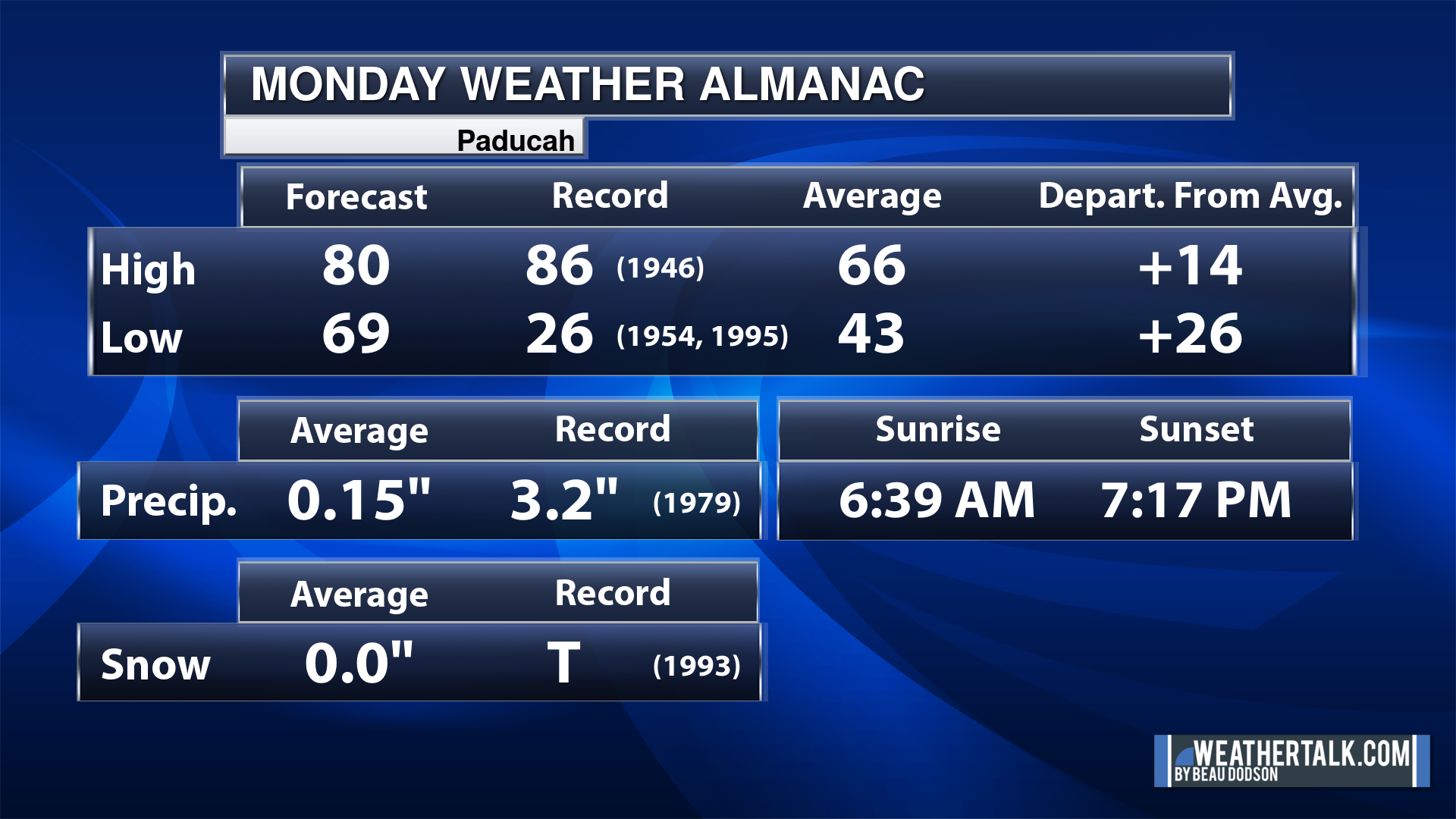
Today’s Local Almanacs (for a few select cities). Your location will be comparable.
Note, the low is this morning’s low and not tomorrows.
The forecast temperature shows you today’s expected high and this morning’s low.
The graphic shows you the record high and record low for today. It shows you what year that occurred, as well.
It then shows you what today’s average temperature is.
It shows you the departures (how may degrees above or below average temperatures will be ).
It shows you the average precipitation for today. Average comes from thirty years of rain totals.
It also shows you the record rainfall for the date and what year that occurred.
The sunrise and sunset are also shown.


![]()
.
.
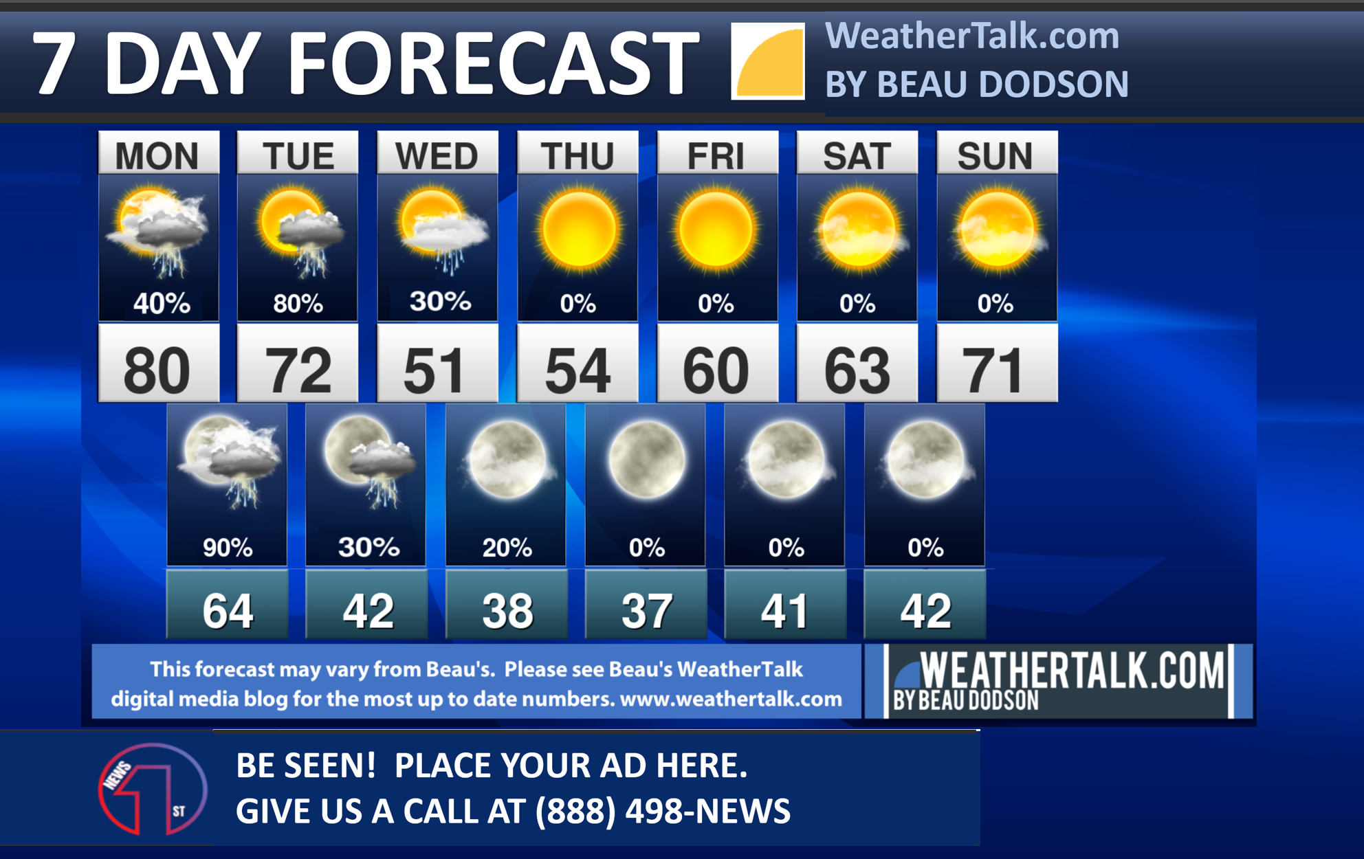
Monday Forecast: Mostly cloudy. A chance of showers and thunderstorms. Chances will be higher over the northern half of the region. A few in the morning and then we will watch the afternoon counties. If storms do form during the PM hours, then they could become severe. Monitor updates.
What is the chance of precipitation?
Far northern southeast Missouri ~ 60%
Southeast Missouri ~ 60%
The Missouri Bootheel ~ 20%
I-64 Corridor of southern Illinois ~ 70%
Southern Illinois ~ 40%
Extreme southern Illinois (southern seven counties) ~ 30%
Far western Kentucky (Purchase area) ~ 20%
The Pennyrile area of western KY ~ 20%
Northwest Kentucky (near Indiana border) ~ 30%
Northwest Tennessee ~ 20%
Coverage of precipitation: Most likely none far south. Becoming more numerous far north. A wide range of % chances of showers and storms today.
Timing of the precipitation: Any given point of time. More likely after 12 PM.
Far northern southeast Missouri ~ 75° to 80°
Southeast Missouri ~ 75° to 80°
The Missouri Bootheel ~ 75° to 80°
I-64 Corridor of southern Illinois ~ 75° to 80°
Southern Illinois ~ 75° to 80°
Extreme southern Illinois (southern seven counties) ~ 75° to 80°
Far western Kentucky ~ 75° to 80°
The Pennyrile area of western KY ~ 75° to 80°
Northwest Kentucky (near Indiana border) ~ 75° to 80°°
Northwest Tennessee ~ 75° to 80°
Winds will be from this direction: South 10 to 30 mph. Gusty.
Wind chill or heat index (feels like) temperature forecast: 75° to 80°
What impacts are anticipated from the weather? Wet roadways. Lightning. Some storms could produce wind and hail.
Should I cancel my outdoor plans? No, but check the Beau Dodson Weather Radars
UV Index: 4. Moderate
Sunrise: 6:40 AM
Sunset: 7:18 PM
.
Monday Night Forecast: Mostly cloudy. Showers and thunderstorms likely. Some storms could become severe.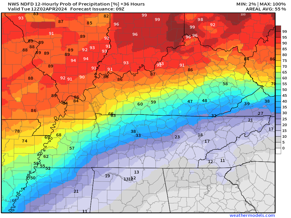
What is the chance of precipitation?
Far northern southeast Missouri ~ 90%
Southeast Missouri ~ 90%
The Missouri Bootheel ~ 80%
I-64 Corridor of southern Illinois ~ 90%
Southern Illinois ~ 90%
Extreme southern Illinois (southern seven counties) ~ 80%
Far western Kentucky (Purchase area) ~ 80%
The Pennyrile area of western KY ~ 70%
Northwest Kentucky (near Indiana border) ~ 90%
Northwest Tennessee ~ 80%
Coverage of precipitation: Numerous
Timing of the precipitation: Any given point of time
Temperature range:
Far northern southeast Missouri ~ 60° to 62°
Southeast Missouri ~ 62° to 64°
The Missouri Bootheel ~ 64° to 66°
I-64 Corridor of southern Illinois ~ 60° to 62°
Southern Illinois ~ 62° to 64°
Extreme southern Illinois (southern seven counties) ~ 62° to 64°
Far western Kentucky ~ 62° to 64°
The Pennyrile area of western KY ~ 64° to 66°
Northwest Kentucky (near Indiana border) ~ 62° to 64°
Northwest Tennessee ~ 64° to 66°
Winds will be from this direction: South southwest 15 to 35 mph. Gusty.
Wind chill or heat index (feels like) temperature forecast: 60° to 66°
What impacts are anticipated from the weather? Wet roadways. Lightning. Some storms could produce damaging wind and hail. Isolated tornadoes.
Should I cancel my outdoor plans? Have a plan B and monitor updates. Monitor the Beau Dodson Weather Radars.
Moonrise: 2:10 AM
Moonset: 11:04 AM
The phase of the moon: Last Quarter
.
Tuesday Forecast: Mostly cloudy. A chance of showers and thunderstorms. Chances will taper west to east as the day wears on. Higher chances east. A few of the thunderstorms could be severe.
What is the chance of precipitation?
Far northern southeast Missouri ~ 40%
Southeast Missouri ~ 40%
The Missouri Bootheel ~ 40%
I-64 Corridor of southern Illinois ~ 60%
Southern Illinois ~ 60%
Extreme southern Illinois (southern seven counties) ~ 70%
Far western Kentucky (Purchase area) ~ 70%
The Pennyrile area of western KY ~ 80%
Northwest Kentucky (near Indiana border) ~ 70%
Northwest Tennessee ~ 70%
Coverage of precipitation: Scattered west but more numerous eastern counties.
Timing of the precipitation: Any given point of time
Far northern southeast Missouri ~ 68° to 70°
Southeast Missouri ~ 68° to 70°
The Missouri Bootheel ~ 70° to 72°
I-64 Corridor of southern Illinois ~ 68° to 72°
Southern Illinois ~ 70° to 72°
Extreme southern Illinois (southern seven counties) ~ 72° to 75°
Far western Kentucky ~ 72° to 75°
The Pennyrile area of western KY ~ 74° to 76°
Northwest Kentucky (near Indiana border) ~ 72° to 74°
Northwest Tennessee ~ 72° to 75°
Winds will be from this direction: Southwest becoming west 10 to 30 mph. Gusty.
Wind chill or heat index (feels like) temperature forecast: 58° to 70°
What impacts are anticipated from the weather? Wet roadways. Lightning. Some storms could produce wind and hail. Isolated tornado risk east.
Should I cancel my outdoor plans? Have a plan B early in the day. Peak rain chances will be early, then ending west to east.
UV Index: 4. Moderate
Sunrise: 6:39 AM
Sunset: 7:19 PM
.
Tuesday Night Forecast: Mostly cloudy. A chance of showers.
What is the chance of precipitation?
Far northern southeast Missouri ~ 10%
Southeast Missouri ~ 10%
The Missouri Bootheel ~ 10%
I-64 Corridor of southern Illinois ~ 20%
Southern Illinois ~ 20%
Extreme southern Illinois (southern seven counties) ~ 20%
Far western Kentucky (Purchase area) ~ 20%
The Pennyrile area of western KY ~ 30%
Northwest Kentucky (near Indiana border) ~ 20%
Northwest Tennessee ~ 20%
Coverage of precipitation: Isolated
Timing of the precipitation: Any given point of time
Temperature range:
Far northern southeast Missouri ~ 34° to 38°
Southeast Missouri ~ 34° to 38°
The Missouri Bootheel ~ 38° to 42°
I-64 Corridor of southern Illinois ~ 34° to 38°
Southern Illinois ~ 34° to 38°
Extreme southern Illinois (southern seven counties) ~ 34° to 38°
Far western Kentucky ~ 34° to 38°
The Pennyrile area of western KY ~ 38° to 42°
Northwest Kentucky (near Indiana border) ~ 34° to 38°
Northwest Tennessee ~ 38° to 42°
Winds will be from this direction: West northwest 10 to 20 mph. Gusty.
Wind chill or heat index (feels like) temperature forecast: 32° to 40°
What impacts are anticipated from the weather? Wet roadways.
Should I cancel my outdoor plans? No, but check the Beau Dodson Weather radars.
Moonrise: 2:56 AM
Moonset: 12:10 PM
The phase of the moon: Waning Crescent
.
Wednesday Forecast: Intervals of clouds. A chance of showers.
What is the chance of precipitation?
Far northern southeast Missouri ~ 20%
Southeast Missouri ~ 20%
The Missouri Bootheel ~ 20%
I-64 Corridor of southern Illinois ~ 60%
Southern Illinois ~ 40%
Extreme southern Illinois (southern seven counties) ~ 40%
Far western Kentucky (Purchase area) ~40%
The Pennyrile area of western KY ~ 60%
Northwest Kentucky (near Indiana border) ~ 60%
Northwest Tennessee ~ 30%
Coverage of precipitation: Scattered
Timing of the precipitation: Any given point of time
Far northern southeast Missouri ~ 52° to 54
Southeast Missouri ~ 52° to 55°
The Missouri Bootheel ~ 52° to 55°
I-64 Corridor of southern Illinois ~ 52° to 55°
Southern Illinois ~ 52° to 55°
Extreme southern Illinois (southern seven counties) ~ 52° to 55°
Far western Kentucky ~ 52° to 55°
The Pennyrile area of western KY ~ 52° to 55°
Northwest Kentucky (near Indiana border) ~ 52° to 55°
Northwest Tennessee ~ 52° to 55°
Winds will be from this direction: Northwest 10 to 25 mph.
Wind chill or heat index (feels like) temperature forecast: 48° to 52°
What impacts are anticipated from the weather? Wet roadways.
Should I cancel my outdoor plans? No, but monitor the Beau Dodson Weather Radars. Some showers are likely.
UV Index: 5. Moderate
Sunrise: 6:37 AM
Sunset: 7:20 PM
.
Wednesday Night Forecast: Partly cloudy. Colder. Any remaining showers will end.
What is the chance of precipitation?
Far northern southeast Missouri ~ 0%
Southeast Missouri ~ 0%
The Missouri Bootheel ~ 0%
I-64 Corridor of southern Illinois ~ 0%
Southern Illinois ~ 0%
Extreme southern Illinois (southern seven counties) ~ 0%
Far western Kentucky (Purchase area) ~ 0%
The Pennyrile area of western KY ~ 0%
Northwest Kentucky (near Indiana border) ~ 0%
Northwest Tennessee ~ 0%
Coverage of precipitation:
Timing of the precipitation:
Temperature range:
Far northern southeast Missouri ~ 32° to 34°
Southeast Missouri ~ 33° to 35°
The Missouri Bootheel ~ 33° to 36°
I-64 Corridor of southern Illinois ~ 32° to 34°
Southern Illinois ~ 32° to 35°
Extreme southern Illinois (southern seven counties) ~ 33° to 36°
Far western Kentucky ~ 33° to 36°
The Pennyrile area of western KY ~ 33° to 36°
Northwest Kentucky (near Indiana border) ~ 34° to 36°
Northwest Tennessee ~ 34° to 38°
Winds will be from this direction: Northwest 10 to 20 mph.
Wind chill or heat index (feels like) temperature forecast: 30° to 35°
What impacts are anticipated from the weather? Wet roadways early in the night.
Should I cancel my outdoor plans? No, but check the Beau Dodson Weather radars.
Moonrise: 3:44 AM
Moonset: 1:22 PM
The phase of the moon: Waning Crescent
.
Click here if you would like to return to the top of the page.

-
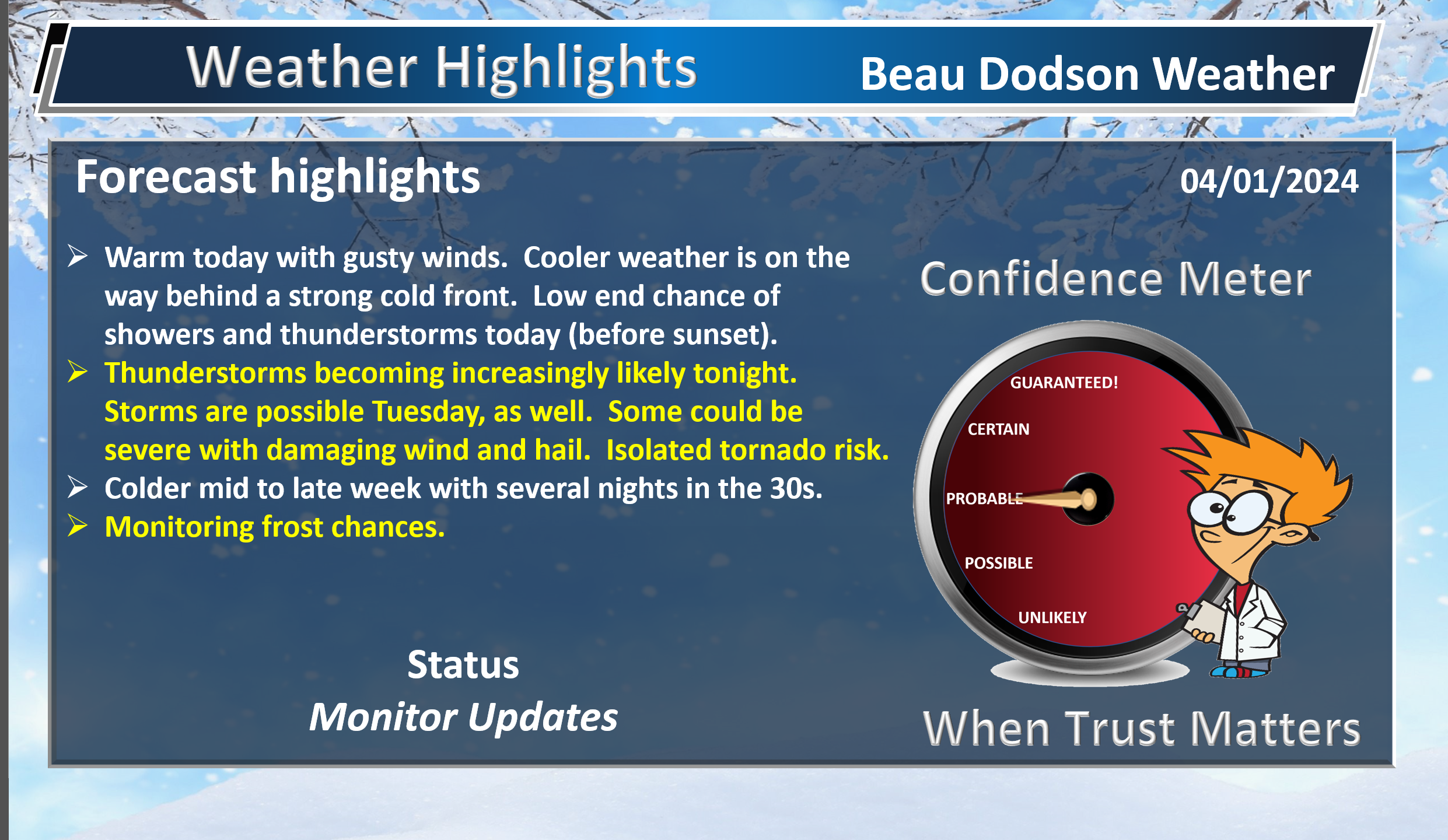
- Warm today. Gusty winds, at times. A few showers and storms possible before sunset, but most of the activity will hold off until after sunset.
- Thunderstorm chances ramp up tonight into Tuesday. Some will be severe.
- Storms will redevelop or continue Tuesday. Especially the eastern half of the region.
- Colder air Wednesday into Friday.
Weather advice:
Do you have any suggestions or comments? Email me at beaudodson@usawx.com
Make sure you have three to five ways of receiving your severe weather information.
Weather Talk is one of those ways.
.
Beau’s Forecast Discussion
** Severe Weather Event Increasingly Likely **
The concern?
Damaging wind and golf ball size hail. A few tornadoes can’t be ruled out, as well. Locally heavy rain and lightning.
When?
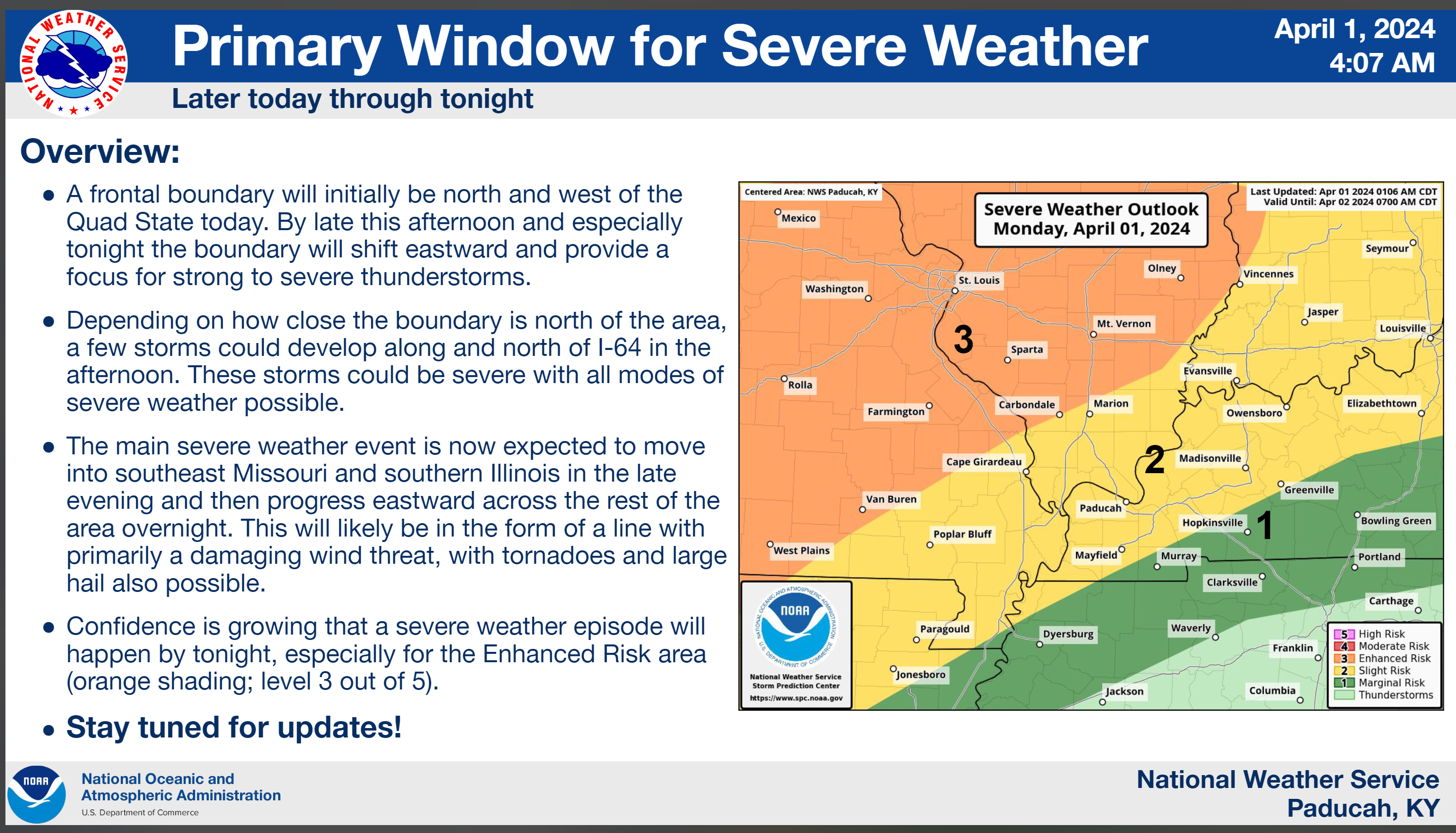
We are focused on late Monday afternoon into the wee early morning hours of Tuesday. Peak time-frame will be 10 PM tonight to 2 PM Tuesday. Some of the thunderstorms may continue into Tuesday afternoon over southeast Illinois, Kentucky, and Tennessee.
The risk will first arrive over southeast Missouri and northern portions of southern Illinois this evening into the overnight hours.
It will then move east across the region late tonight into tomorrow.
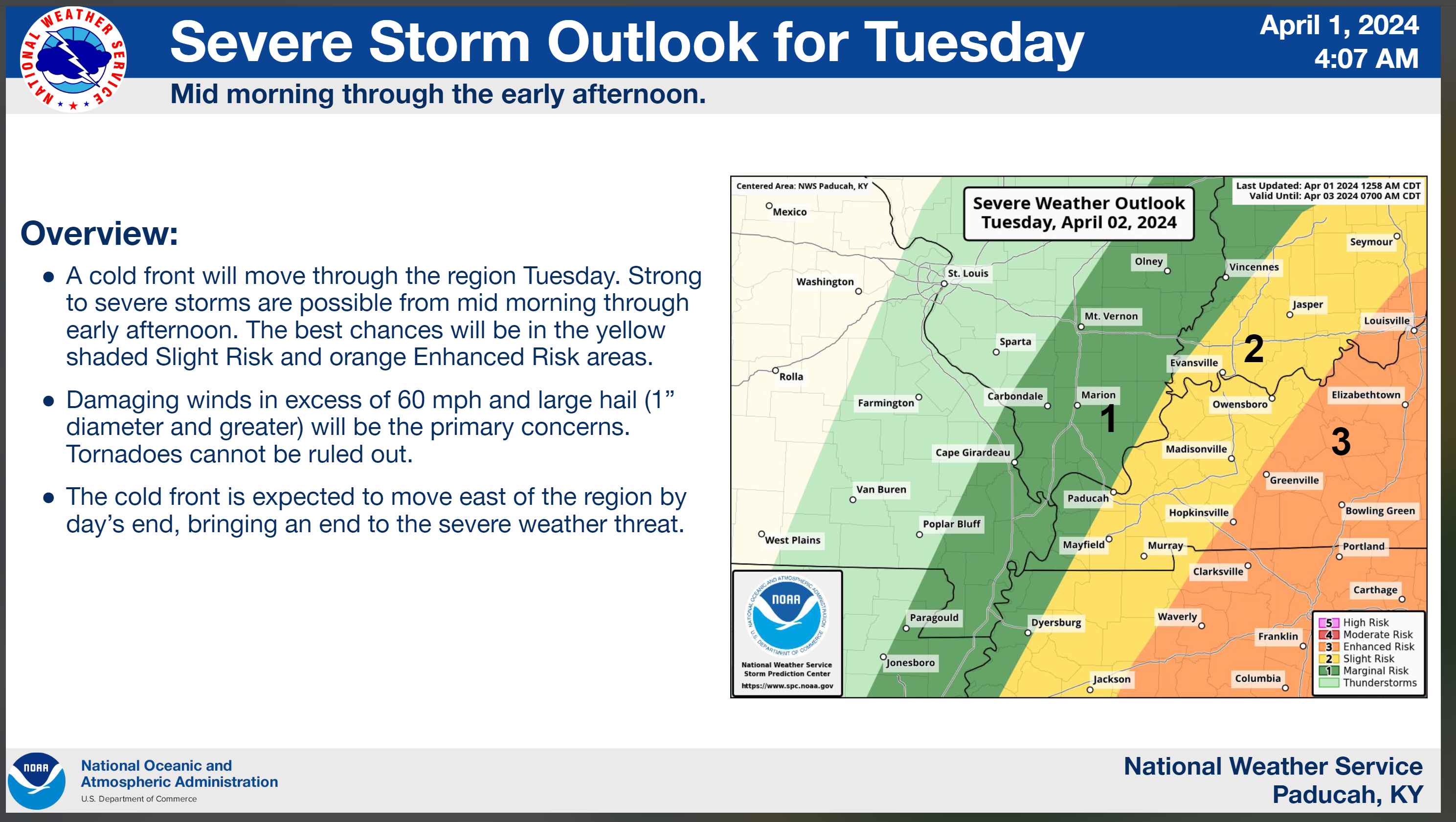
A second round of storms will develop Tuesday mid to late morning into the afternoon hours. That round would mainly be southern Illinois into Kentucky and Tennessee. More likely east vs west. Some of those storms could be severe, as well.
Where?
See the graphics. There is a risk area-wide later today/tonight into tomorrow morning. Then, the risk shifts a bit more east tomorrow.
Certainties
Thunderstorms will occur. Some will be severe. Severe thunderstorm and/or tornado watches will be issued. Some warnings will be issued.
Uncertainties
There are questions about the exact timing county by county. Models are not handling this situation very well. It appears a few storms could develop as early as this afternoon over our northern counties, but most likely the bulk of this event will be very late tonight into Tuesday morning.
There are questions about coverage. Some data shows a line of storms moving into the region late tonight, but then it falls apart leaving a boundary. New storms form along the boundary tomorrow.
Other data shows a solid line of storms sweeping across the entire region.
Confidence in the coverage is lower than usual. Monitor updates.
Call to action
Make sure you have 3 to 5 ways of receiving severe weather information.
The www.weathertalk.com Beau Dodson Weather app is one of those ways.
We have a new service that CALLS your home phone of cell phone if you house is in a tornado or severe thunderstorm warning. You can subscribe to that here https://weathercallservices.com/beau-dodson-weather
I have partnered with WeatherCall to bring you this service.
A weather radio is a great source of weather information.
Other local television weather apps.
Make sure your WEA is on. Google Android or Apple WEA severe weather alerts. How to turn on my WEA. Google that.
Outdoor sirens can be a source for those outside.
Forecast Discussion.
The risk of severe weather continues to increase Monday afternoon and especially Monday night.
We are in a level one, two, and three risk across the region.
I encourage you to not get caught up in the colors. Weather doesn’t always follow our nicely drawn maps and color grids.
A tornado in the level one zone is the same as a tornado in a level three zone. The damage is the same. Thus, let’s not focus on the colors. Focus on the forecast.
Most of our regions EF3 and greater intensity tornadoes have occurred in level one, two, and three risks.
The forecast is for severe thunderstorms to develop Monday afternoon into early Tuesday morning. Tornadoes, damaging wind, and large hail will be a concern.
If supercells form, then some of the hail could reach golf ball size or perhaps even larger.
Supercells tend to be scattered vs a solid line of storms. A solid line of storms would be more likely to produce damaging wind and short-lived tornadoes.
A squall line looks like this
Supercells look like this. Supercells are discrete.
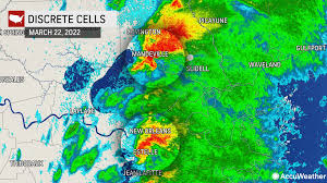
Supercells tend to produce longer tracked tornadoes, higher damaging wind gusts, and larger hail.
Early on, supercells appear possible. Then, a line of storms should form.
The bulk of our regions tornadoes occur in level one, two, and three risk zones. So, again, don’t get too caught up in the colors.
The color levels are good for guidance, but don’t tell the entire story. I try to remind everyone of this during every event.
For example, the Harrisburg EF4 tornadoes, several years ago, was in a level two risk. A slight risk.
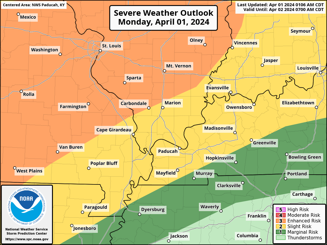
Graphic one shows you the Storm Prediction Center’s official severe weather outlook. Adjustments are still possible. They have changed this outlook three times in the last 24 hours.
Which is one more reason not to get too caught up in the colors.
If storms train over the same area, then some brief flooding concerns could develop. Avoid flooded roadways, as always.
There will be quite a bit of wind shear aloft with this event. Wind shear is the turning of wind with height and the increase in wind speed with height.
This is an ingredient for severe thunderstorms.
Dew points will rise into the 60s. That is plenty of moisture for severe thunderstorms to tap into.
CAPE values (instability) will rise into the 500 to 1500 range Monday afternoon and evening.
All of those are ingredients for severe weather.
The Paducah, Kentucky, National Weather Service made the fifth graphic.
Double click graphics to enlarge them.
We will have some lingering light showers Wednesday.
Turning colder Wednesday into Friday. I can’t rule out some frost and or a light freeze this week, again.
Dry Thursday into Saturday.
![]()
.
Click here if you would like to return to the top of the page.
This outlook covers southeast Missouri, southern Illinois, western Kentucky, and far northwest Tennessee.

.
Today’s Storm Prediction Center’s (SPC) Severe Weather Outlook
Light green is where thunderstorms may occur but should be below severe levels.
Dark green is a level one risk. Yellow is a level two risk. Orange is a level three (enhanced) risk. Red is a level four (moderate) risk. Pink is a level five (high) risk.
One is the lowest risk. Five is the highest risk.
A severe storm is one that produces 58 mph wind or higher, quarter or larger size hail, and/or a tornado.
Explanation of tables. Click here.
Day One Severe Weather Outlook

Day One Severe Weather Outlook. Zoomed in on our region.

.
Day One Tornado Probability Outlook

Day One Regional Tornado Outlook. Zoomed in on our region.

.
Day One Large Hail Probability Outlook

Day One Regional Hail Outlook. Zoomed in on our region.

.
Day One High wind Probability Outlook

Day One Regional Wind Outlook. Zoomed in on our region.

.
Tomorrow’s severe weather outlook. Day two outlook.

Day Two Outlook. Zoomed in on our region.

.
Day Three Severe Weather Outlook

.

.
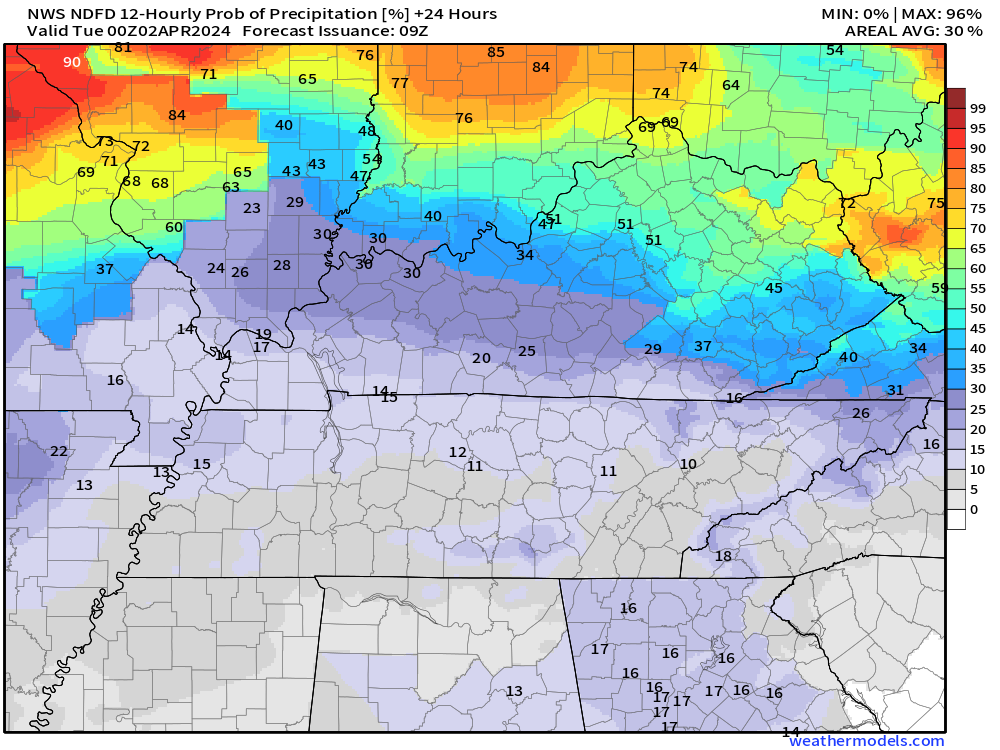
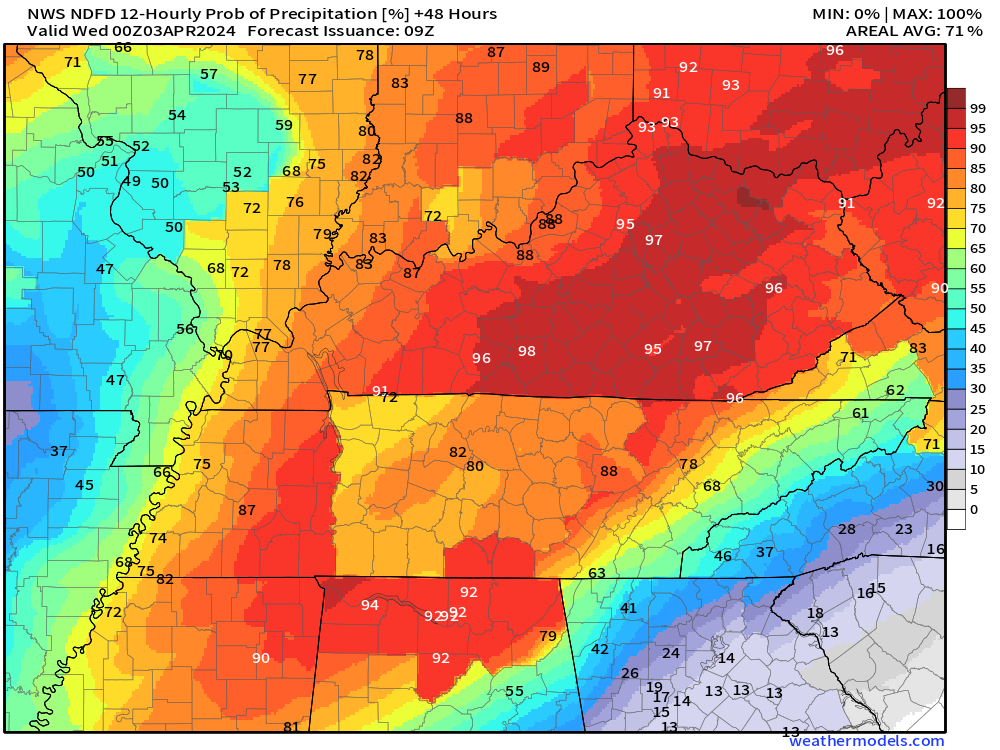
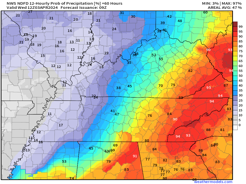
The images below are from NOAA’s Weather Prediction Center.
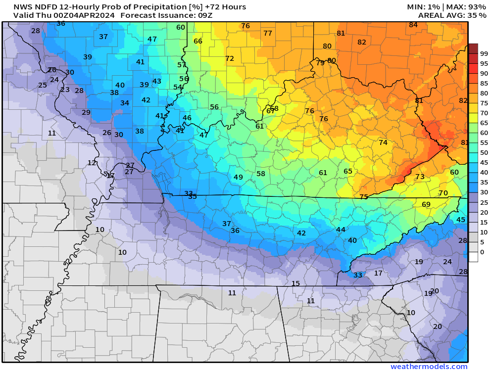
24-hour precipitation outlook..
 .
.
.
48-hour precipitation outlook.
. .
.
![]()
_______________________________________
.

Click here if you would like to return to the top of the page.
Again, as a reminder, these are models. They are never 100% accurate. Take the general idea from them.
What should I take from these?
- The general idea and not specifics. Models usually do well with the generalities.
- The time-stamp is located in the upper left corner.
.
What am I looking at?
You are looking at computer model data. Meteorologists use many different models to forecast the weather.
Occasionally, these maps are in Zulu time. 12z=7 AM. 18z=1 PM. 00z=7 PM. 06z=1 AM
Green represents light rain. Dark green represents moderate rain. Yellow and orange represent heavier rain.
.
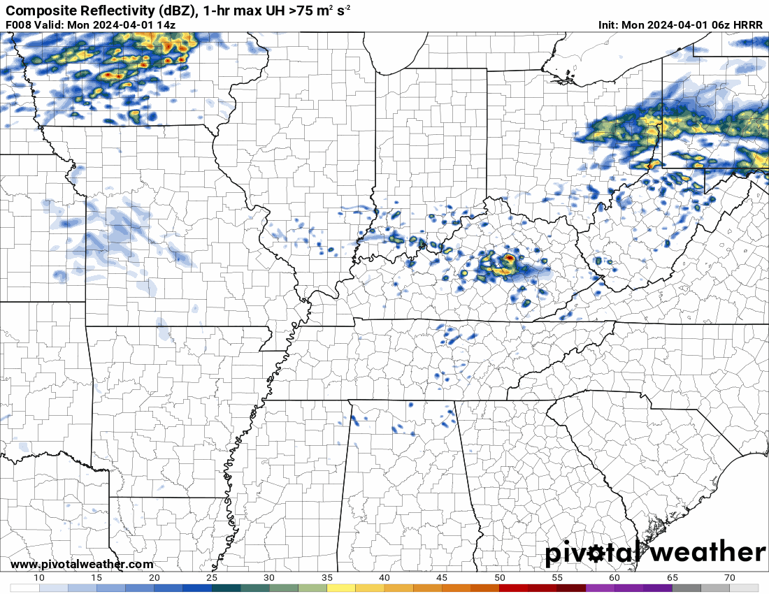
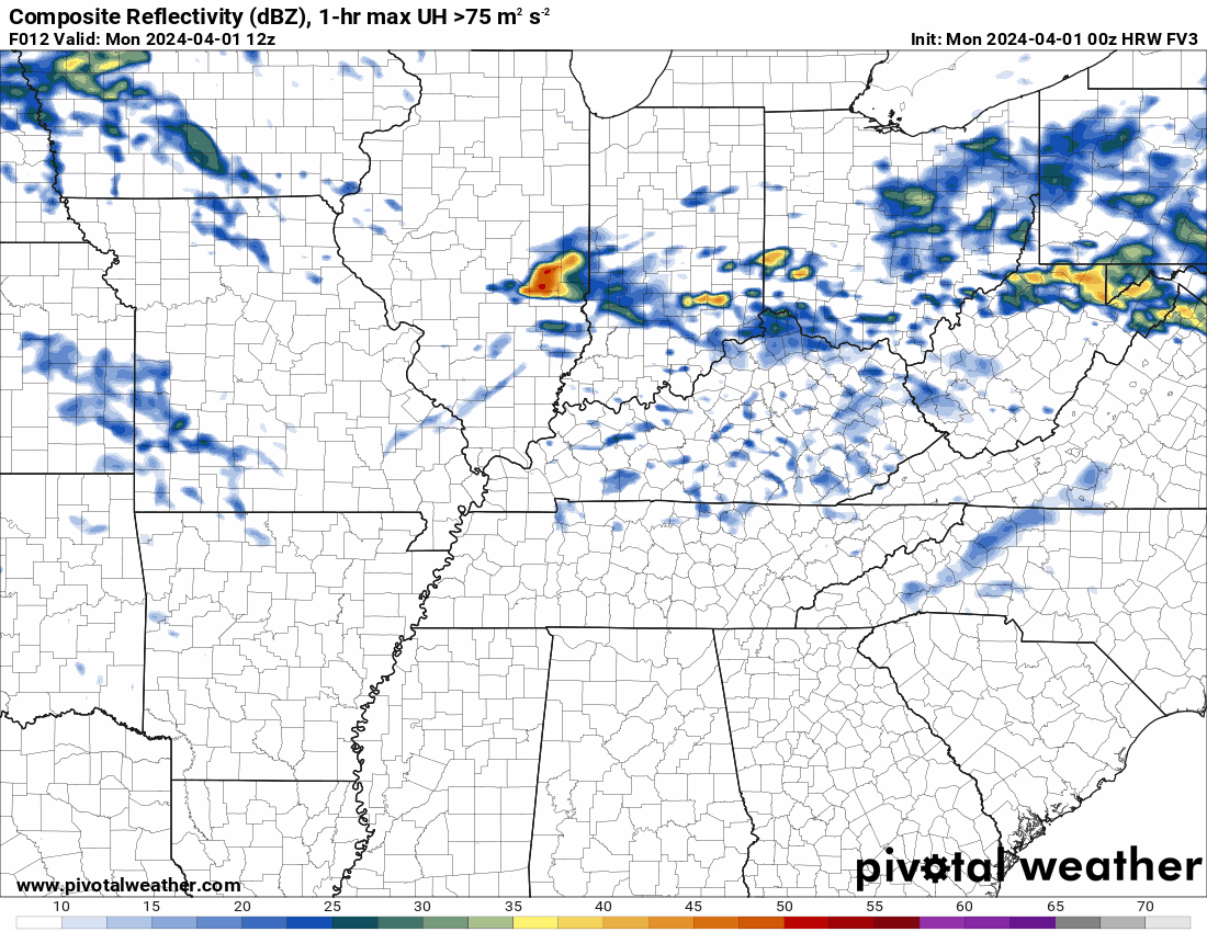
This animation is the FVS Model.
Occasionally, these maps are in Zulu time. 12z=7 AM. 18z=1 PM. 00z=7 PM. 06z=1 AM
Double click images to enlarge them. Blue is snow. Pink is a wintry mix. Green is rain.
.
This animation is the NAM Model.
Occasionally, these maps are in Zulu time. 12z=7 AM. 18z=1 PM. 00z=7 PM. 06z=1 AM
Double click images to enlarge them.
.
This animation is the HRRR Model.
Green is rain. Yellow and orange are heavier rain. Pink is a wintry mix. Blue is snow. Dark blue is heavier snow.
Occasionally, these maps are in Zulu time. 12z=7 AM. 18z=1 PM. 00z=7 PM. 06z=1 AM
Double click images to enlarge them.
.
This animation is the FVS3 Model.
Green is rain. Yellow and orange are heavier rain. Pink is a wintry mix. Blue is snow. Dark blue is heavier snow.
Occasionally, these maps are in Zulu time. 12z=7 AM. 18z=1 PM. 00z=7 PM. 06z=1 AM
Double click images to enlarge them.
.
This animation is the EC Model.
Green is rain. Yellow and orange are heavier rain. Pink is a wintry mix. Blue is snow. Dark blue is heavier snow.
Occasionally, these maps are in Zulu time. 12z=7 AM. 18z=1 PM. 00z=7 PM. 06z=1 AM
Double click images to enlarge them.
..![]()

.
Click here if you would like to return to the top of the page.
.Average high temperatures for this time of the year are around 62 degrees.
Average low temperatures for this time of the year are around 40 degrees.
Average precipitation during this time period ranges from 0.60″ to 1.20″
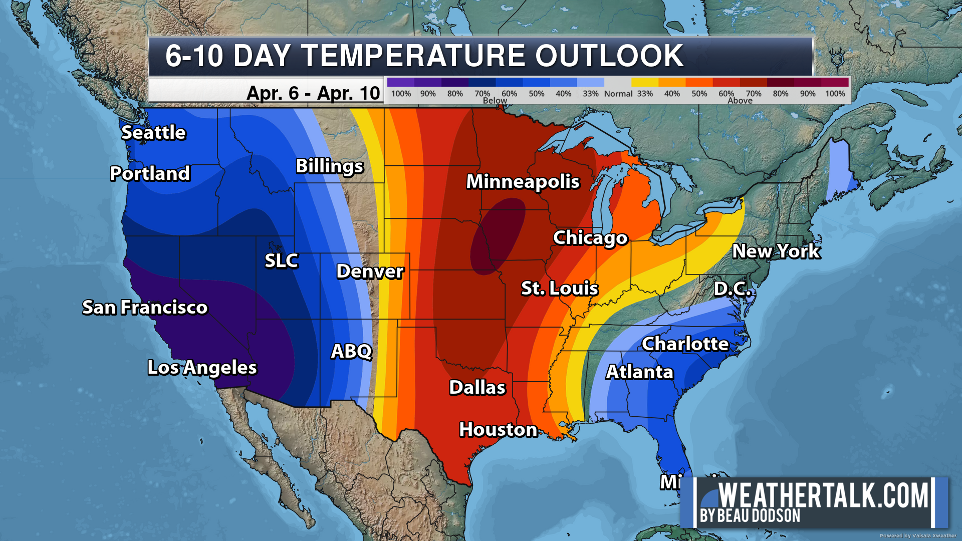
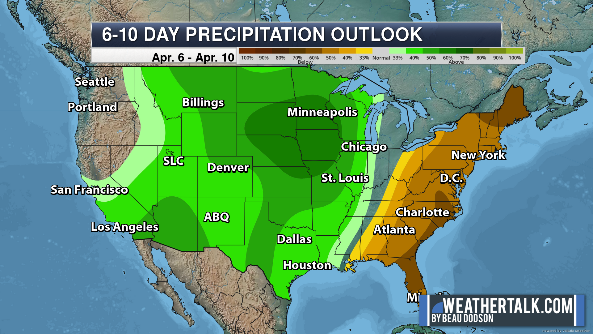
Six to Ten Day Outlook.
Blue is below average. Red is above average. The no color zone represents equal chances.
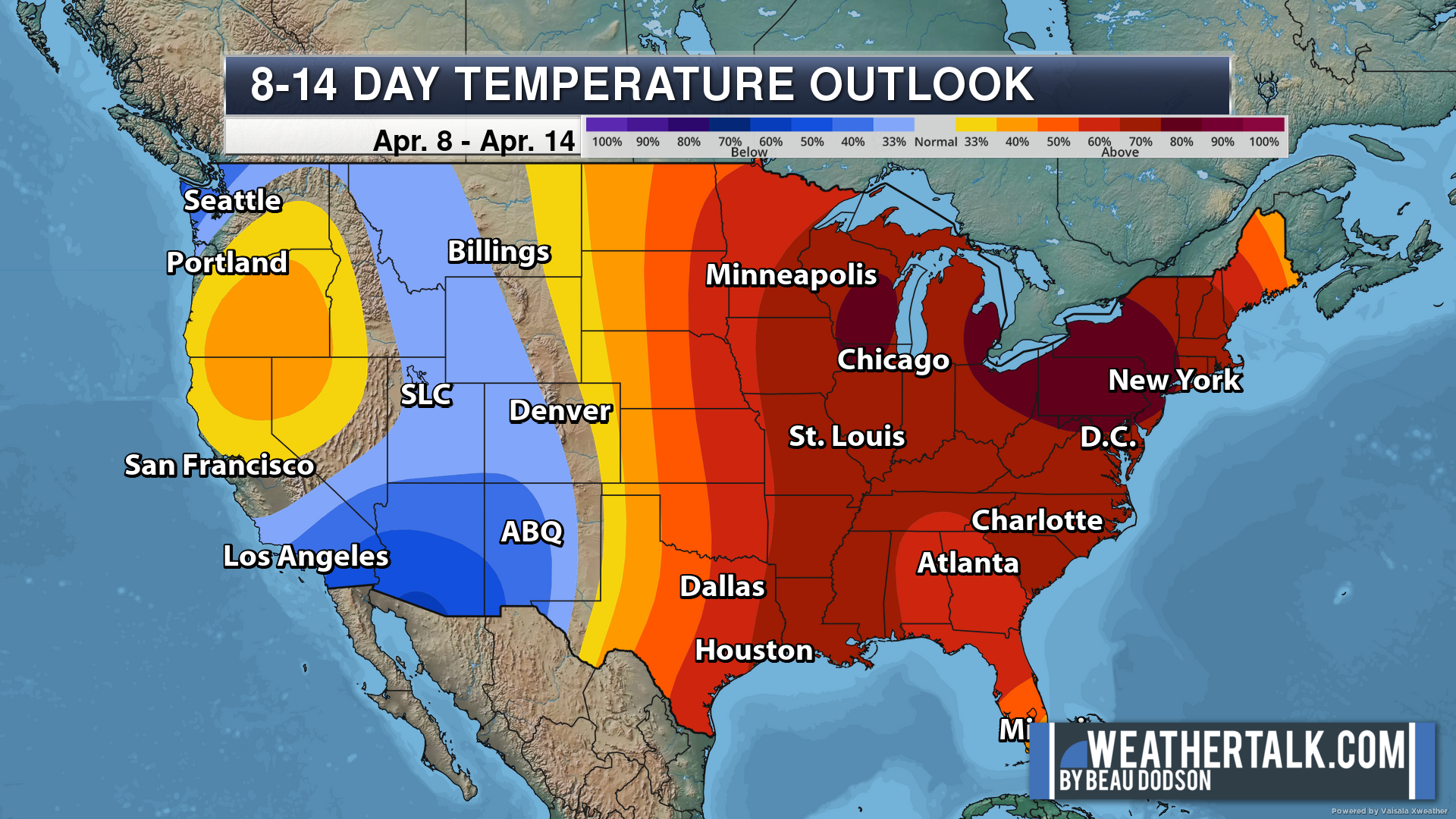
Average highs for this time of the year are in the lower 60s. Average lows for this time of the year are in the lower 40s.
Green is above average precipitation. Yellow and brown favors below average precipitation. Average precipitation for this time of the year is around one inch per week.
.

Average low temperatures for this time of the year are around 41 degrees.
Average precipitation during this time period ranges from 0.60″ to 1.20″
.
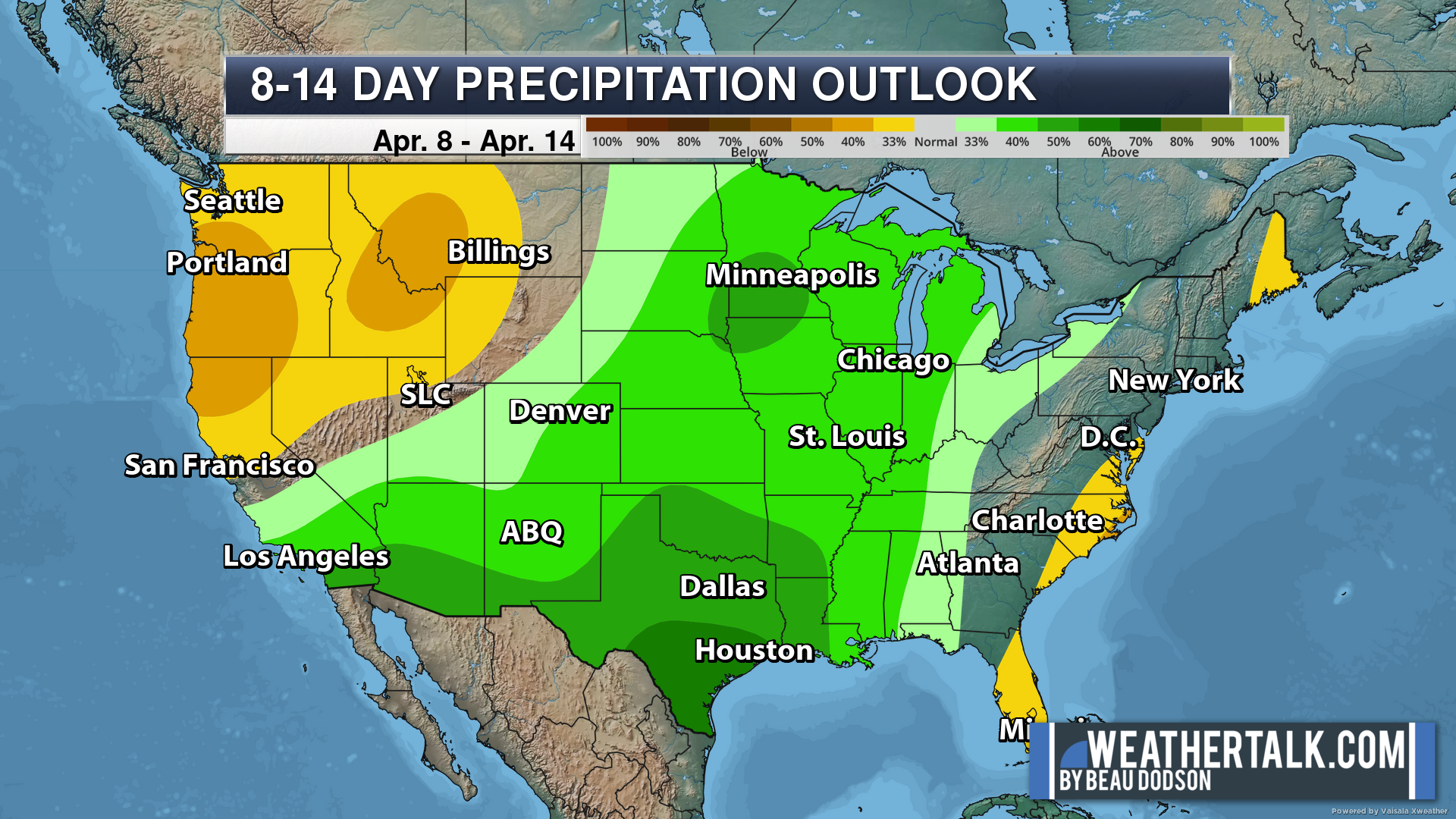
Eight to Fourteen Day Outlook.
Blue is below average. Red is above average. The no color zone represents equal chances.
Green is above average precipitation. Yellow and brown favors below average precipitation. Average precipitation for this time of the year is around one inch per week.
.
![]()
The app is for subscribers. Subscribe at www.weathertalk.com/welcome then go to your app store and search for WeatherTalk
Subscribers, PLEASE USE THE APP. ATT and Verizon are not reliable during severe weather. They are delaying text messages.
The app is under WeatherTalk in the app store.

Apple users click here

Android users click here
.

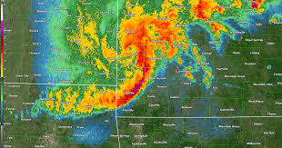
Radars and Lightning Data
Interactive-city-view radars. Clickable watches and warnings.
https://wtalk.co/B3XHASFZ
If the radar is not updating then try another one. If a radar does not appear to be refreshing then hit Ctrl F5. You may also try restarting your browser.
Backup radar site in case the above one is not working.
https://weathertalk.com/morani
Regional Radar
https://imagery.weathertalk.com/prx/RadarLoop.mp4
** NEW ** Zoom radar with chaser tracking abilities!
ZoomRadar
Lightning Data (zoom in and out of your local area)
https://wtalk.co/WJ3SN5UZ
Not working? Email me at beaudodson@usawx.com
National map of weather watches and warnings. Click here.
Storm Prediction Center. Click here.
Weather Prediction Center. Click here.
.

Live lightning data: Click here.
Real time lightning data (another one) https://map.blitzortung.org/#5.02/37.95/-86.99
Our new Zoom radar with storm chases
.
.

Interactive GOES R satellite. Track clouds. Click here.
GOES 16 slider tool. Click here.
College of DuPage satellites. Click here
.

Here are the latest local river stage forecast numbers Click Here.
Here are the latest lake stage forecast numbers for Kentucky Lake and Lake Barkley Click Here.
.
.
Find Beau on Facebook! Click the banner.


 .
.