.

Click one of the links below to take you directly to each section.
- Storm tracking tools. Radars, lightning, satellite. (I moved this to the bottom)
- Go to today’s forecast
- Go to the graphic-cast
- Go to the severe weather outlook
- Go to the weather forecast discussion
- Go to the model future-cast radars
- Go to Weatherbrains
- View some of our charity work. Your subscription dollars help support these causes.
Do you have questions or suggestions? If so, please email me. Beaudodson@usawx.com
.

Today: No
.
Tomorrow: No.
.

Click here if you would like to return to the top of the page
.

Today through Tuesday night.
- Is accumulating snow or ice in the forecast? No.
- Is lightning in the forecast? Yes. Some lightning is possible from Poplar Bluff, Missouri, to Perryville, Missouri, to Mt Vernon, Illinois. My far western and northwestern counties. This would mainly be Tuesday and Tuesday night. Otherwise, the lightning risk is small elsewhere. Medium confidence. I will need to monitor Tuesday night in case some storms push further south and east.
- Is severe weather in the forecast? No.
* The NWS officially defines severe weather as 58 mph wind or great, 1″ hail or larger, and/or tornadoes - Is Flash flooding in the forecast? No.
.

Wednesday through Sunday.
- Is accumulating snow or ice in the forecast? No.
- Is lightning in the forecast? Yes. Lightning is likely Wednesday into Thursday night. Storms may end by Friday (monitor). Saturday and Sunday appear to be dry.
- Is severe weather in the forecast? Monitor updates. Some strong storms are possible Wednesday into Thursday night.
* The NWS officially defines severe weather as 58 mph wind or great, 1″ hail or larger, and/or tornadoes - Is flash flooding in the forecast? Monitor updates. Locally heavy rain is possible Wednesday night into Thursday night.
.
Today’s Facebook weather discussion link
Click here
.
* The Missouri Bootheel includes Dunklin, New Madrid, and Pemiscot Counties
* Northwest Kentucky includes Daviess, Henderson, McLean Union, and Webster Counties
.
Have there been any changes in the forecast over the last 24 hours?
.
Increased temperatures Tuesday and Wednesday.
.
April 28, 2019
Sunday’s Forecast: Morning clouds. Clearing. Becoming partly to mostly sunny. Breezy, at times.
My confidence in the forecast verifying: High (70% confidence in the forecast))
Temperature range: MO Bootheel 70° to 74° SE MO 66° to 70° South IL 64° to 68° Northwest KY (near Indiana border) 64° to 68° West KY 64° to 68° NW TN 68° to 72°
Wind direction and speed: North winds at 10 to 20 mph. Gusty. Winds becoming east at 7 to 14 mph.
Wind chill or heat index (feels like) temperature forecast: 60° to 68°
What is the chance/probability of precipitation? MO Bootheel 0% Southeast MO 0% IL 0% Northwest KY (near Indiana border) 0% Western KY 0% NW TN 0%
Note, what does the % chance actually mean? A 20% chance of rain does not mean it won’t rain. It simply means most areas will remain dry.
Coverage of precipitation: None
What impacts are anticipated from the weather? None
Should I cancel my outdoor plans? No
UV Index: 7 High. Areas with clouds will be lower, of course.
Sunrise: 6:04 AM
.
Sunday night Forecast: Partly cloudy. Breezy.
My confidence in the forecast verifying: Medium (60% confidence in the forecast)
Temperature range: MO Bootheel 52° to 54° SE MO 50° to 54° South IL 50° to 55° Northwest KY (near Indiana border) 50° to 55° West KY 52° to 54° NW TN 52° to 54°
Wind direction and speed: S to SW at 10 to 20 mph
Wind chill or heat index (feels like) temperature forecast: 48° to 52°
What is the chance/probability of precipitation? MO Bootheel 0% Southeast MO 0% IL 0% Northwest KY (near Indiana border) 0% Western KY 0% NW TN 0%
Note, what does the % chance actually mean? A 20% chance of rain does not mean it won’t rain. It simply means most areas will remain dry
Coverage of precipitation: None.
What impacts are anticipated from the weather? None
Should I cancel my outdoor plans? No
Sunset: 7:42 PM
Moonrise: 3:09 AM
The phase of the moon: Waning Crescent
Moonset: 1:47 PM
.
.
April 29, 2019
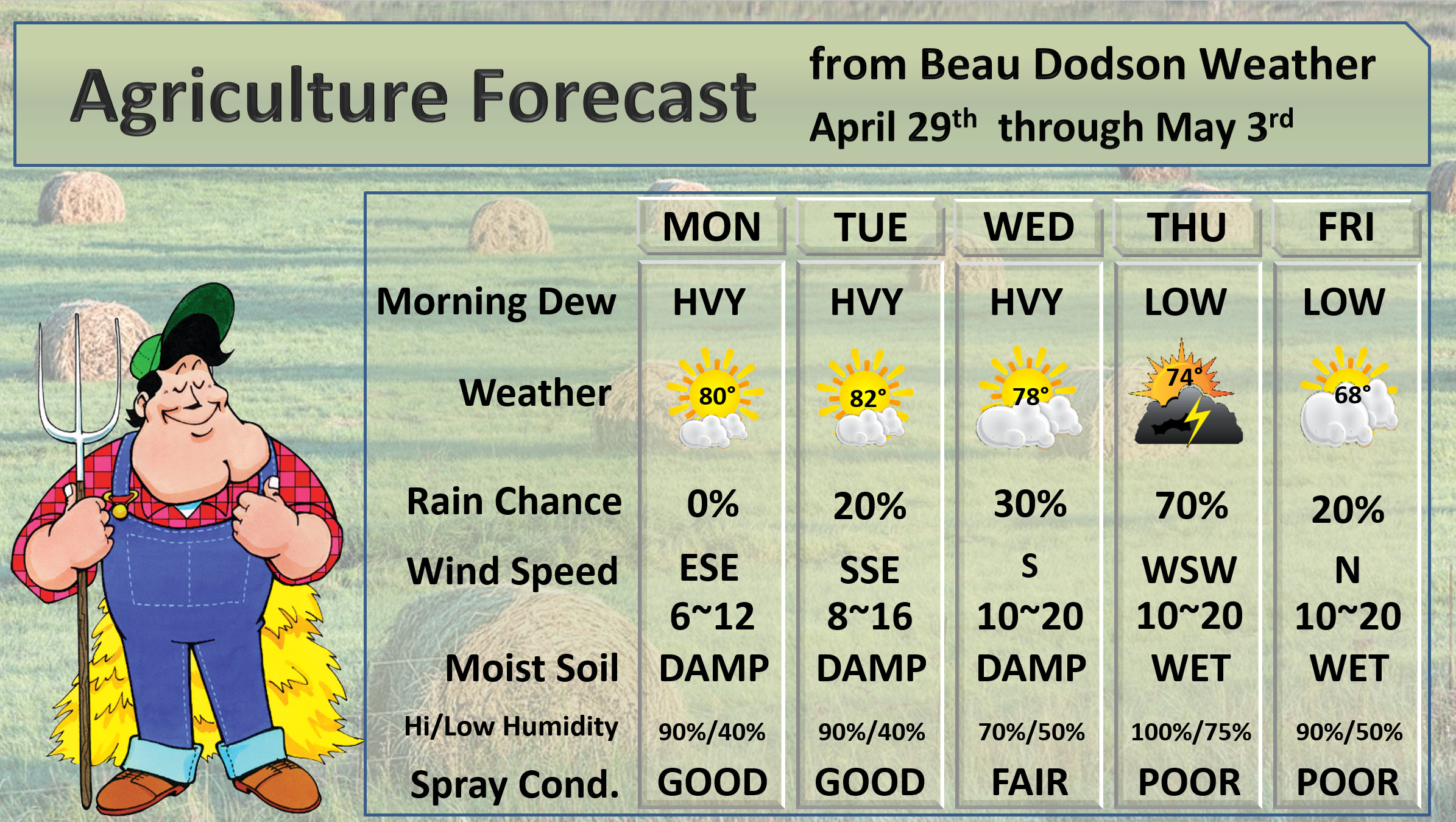
Monday’s Forecast: A mix of sun and clouds. Warm and breezy. Isolated showers and thunderstorms from Butler County, MO northeast towards Jefferson County in Illinois. Most of the area will remain dry.
My confidence in the forecast verifying: Medium (60% confidence in the forecast))
Temperature range: MO Bootheel 78° to 82° SE MO 78° to 80° South IL 76° to 80° Northwest KY (near Indiana border) 76° to 80° West KY 78° to 82° NW TN 78° to 82°
Wind direction and speed: South and southwest at 10 to 20 mph. Gusty winds.
Wind chill or heat index (feels like) temperature forecast: 74° to 82°
What is the chance/probability of precipitation? MO Bootheel 10% Southeast MO 20% IL 20% Northwest KY (near Indiana border) 0% Western KY 0% NW TN 0%
Note, what does the % chance actually mean? A 20% chance of rain does not mean it won’t rain. It simply means most areas will remain dry.
Coverage of precipitation: None to isolated over my far western counties of SE MO and far northwest counties in SW IL.
What impacts are anticipated from the weather? None for most areas. Slight chance of wet roads and lightning in the above-mentioned area.
Should I cancel my outdoor plans? No
UV Index: 8 Very high.
Sunrise: 6:04 AM
.
Monday night Forecast: Partly cloudy. Breezy.
My confidence in the forecast verifying: Medium (60% confidence in the forecast)
Temperature range: MO Bootheel 60° to 64° SE MO 58° to 60° South IL 58° to 60° Northwest KY (near Indiana border) 56° to 60° West KY 58° to 60° NW TN 60° to 64°
Wind direction and speed: S to SW at 7 to 14 mph
Wind chill or heat index (feels like) temperature forecast: 56° to 62°
What is the chance/probability of precipitation? MO Bootheel 0% Southeast MO 10% IL 10% Northwest KY (near Indiana border) 0% Western KY 0% NW TN 0%
Note, what does the % chance actually mean? A 20% chance of rain does not mean it won’t rain. It simply means most areas will remain dry
Coverage of precipitation: Most likely none.
What impacts are anticipated from the weather? None
Should I cancel my outdoor plans? No
Sunset: 7:42 PM
Moonrise: 3:09 AM
The phase of the moon: Waning Crescent
Moonset: 1:47 PM
.
.
April 30, 2019
Tuesday’s Forecast: A mix of sun and clouds. Warm. Breezy. Scattered showers and thunderstorms from Butler County, MO northeast towards Jefferson County in Illinois. Most of the area will remain dry.
My confidence in the forecast verifying: Medium (60% confidence in the forecast))
Temperature range: MO Bootheel 80° to 84° SE MO 78° to 82° South IL 76° to 82° Northwest KY (near Indiana border) 78° to 80° West KY 78° to 82° NW TN 80° to 84°
Wind direction and speed: South at 10 to 20 mph with higher gusts likely.
Wind chill or heat index (feels like) temperature forecast: 78° to 84°
What is the chance/probability of precipitation? MO Bootheel 10% Southeast MO 30% IL 30% Northwest KY (near Indiana border) 0% Western KY 0% NW TN 0%
Note, what does the % chance actually mean? A 20% chance of rain does not mean it won’t rain. It simply means most areas will remain dry.
Coverage of precipitation: Isolated across southeast MO and southern IL Most of my forecast counties should remain dry. Areas from Poplar Bluff northeast into Perry County, Missouri and then northeast towards Mt. Vernon may see a few spotty showers and storms.
What impacts are anticipated from the weather? None across most of my area. Wet roads and lightning in the above-mentioned areas.
Should I cancel my outdoor plans? No
UV Index: 3 to 6 (depends on clouds) Moderate to high.
Sunrise: 6:01 AM
.
Tuesday night Forecast: Quite a few clouds. Mild. Breezy. A chance of showers and thunderstorms from southeast Missouri into southern Illinois. Lesser chances as you move east and southeast.
My confidence in the forecast verifying: Medium (50% confidence in the forecast)
Temperature range: MO Bootheel 63° to 66° SE MO 63° to 66° South IL 63° to 66° Northwest KY (near Indiana border) 62° to 64° West KY 63° to 66° NW TN 63° to 66°
Wind direction and speed: S to SW at 10 to 20 mph. Gusty.
Wind chill or heat index (feels like) temperature forecast: 62° to 66°
What is the chance/probability of precipitation? MO Bootheel 30% Southeast MO 40% IL 40% Northwest KY (near Indiana border) 20% Western KY 20% NW TN 20%
Note, what does the % chance actually mean? A 20% chance of rain does not mean it won’t rain. It simply means most areas will remain dry
Coverage of precipitation: Scattered over southeast Missouri and southern Illinois. Chances decrease as you move south and east into Kentucky and Tennessee.
What impacts are anticipated from the weather? Wet roadways and lightning in the above-mentioned areas.
Should I cancel my outdoor plans? No, but check radars.
Sunset: 7:44 PM
Moonrise: 4:11 AM
The phase of the moon: Waning Crescent
Moonset: 3:41 PM
.
Wednesday: Medium confidence. A mix of sun and clouds. Warm. A 40% chance of a shower or thunderstorm during the day and a 50% chance at night. High temperatures in the upper 70’s. Low temperatures in the upper 50’s to lower 60’s. South and southwest wind 10 to 20 mph and gusty.
.
Thursday: Medium confidence. Cloudy. Warm. A 60% chance of a shower or thunderstorm during the day and a 40% chance at night. High temperatures in the middle 70’s. Low temperatures in the middle 50’s. South and southwest wind 10 to 20 mph and gusty. Winds becoming west and northwest late Thursday at speeds of 8 to 16 mph.
.
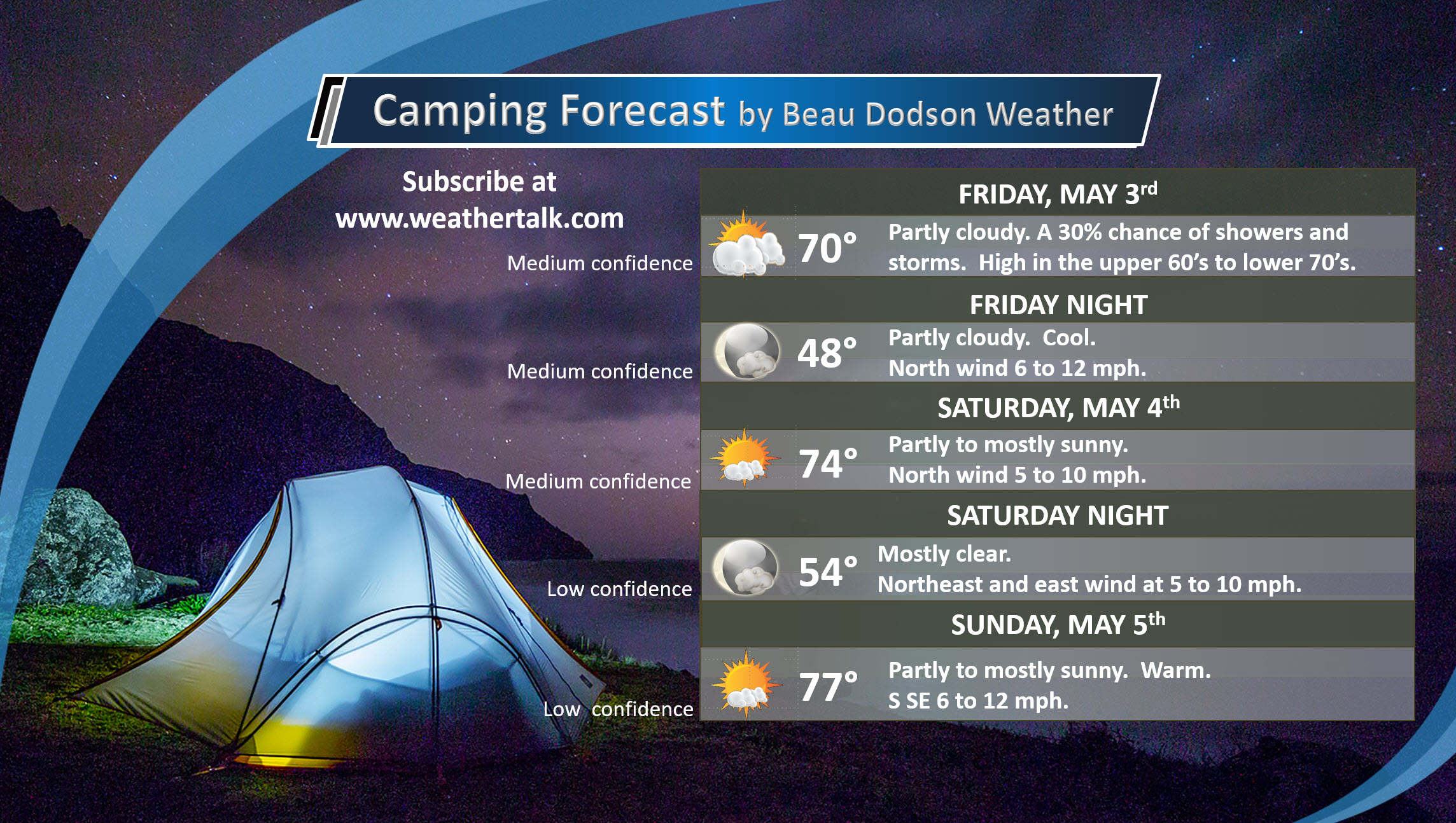
Friday: Medium confidence. Partly cloudy. A 30% chance of a shower or thunderstorm during the day. Dry Friday night. High temperatures in the upper 60’s to lower 70’s. Low temperatures in the upper 40’s. North wind at 7 to 14 mph.
.
.
Learn more about the UV index readings. Click here.
.
.
Graphic-cast
Click here if you would like to return to the top of the page
.
** These graphic-forecasts may vary a bit from my forecast above **
CAUTION: I have these graphics set to auto-update on their own. Make sure you read my hand-typed forecast above.
During active weather check my handwritten forecast.
.
Missouri


.
Illinois


.
Kentucky


.
Tennessee


.

The National Weather Service defines a severe thunderstorm as one that produces quarter size hail or larger, 58 mph winds or greater, and/or a tornado.
.
Today and tomorrow: No severe storms.
Monday through Friday: Some storms could be intense Wednesday into Thursday night. Monitor updates.
.
Be sure and have WeatherOne turned on in your WeatherTalk accounts. That is the one for winter storms, ice storms, and severe weather.
Log into your www.weathertalk.com
Click the personal notification settings tab.
Turn on WeatherOne. Green is on. Red is off.

.

Here is the latest graphic from the WPC/NOAA.
.
This map shows precipitation totals.
.
24-hour precipitation outlook.
.

.
48-hour precipitation outlook.
.
.
.
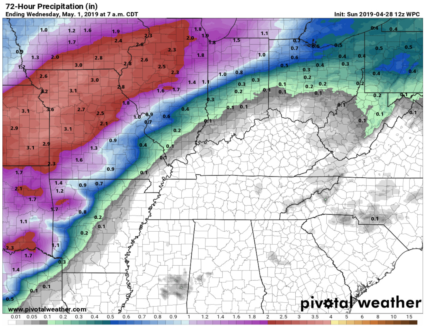
72-hour precipitation outlook.
.

.
Totals added together. This includes day one through seven.

.

- Dry today into Tuesday (for most of the area).
- A look at the rest of the week. Some rain likely.
Current conditions.

.
Click here if you would like to return to the top of the page
.
Forecast discussion.
Sunday into Tuesday.
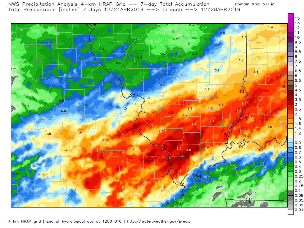
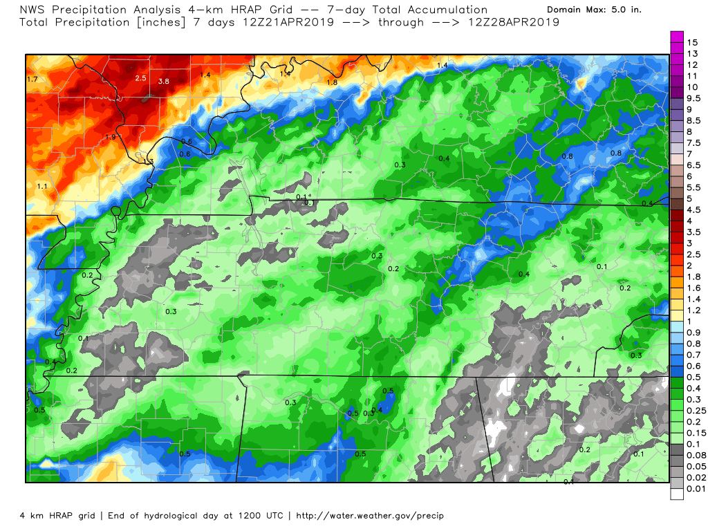
Rain totals varied GREATLY over the past seven days.
Some areas received less than 0.10″. Some areas received more than three inches.
Click to enlarge these regional views.
This is from the last seven days.
.
.
A fairly quiet forecast over the next 48 hours. A decent warming trend to start the new work-week.
Many areas will hit the upper 70’s to lower 80’s Monday into Wednesday.
I am monitoring thunderstorms chances (mentioned above) across southeast Missouri and Southern Illinois. That would mainly be Tuesday and Tuesday night.
Kentucky and Tennessee should remain dry today through Tuesday night.
.
Long Range
Wednesday into Sunday.
Active weather.
.
A series of cold fronts, stationary fronts, and upper-level disturbances will impact the area.
Notice on this rainfall map where the heaviest totals have been placed? Notice the sharp cut-off in totals to the east/southeast?
That is because of the stalled frontal boundary. Again, placement of the heavy rain is still in play.
This graphic takes us through 8 AM Wednesday.
Rain chances begin to increase across the region Wednesday afternoon into Thursday night. Perhaps ending as early as Thursday night/Friday morning. I am hoping Friday remains dry. Some of the guidance continues the rain chances into Friday morning.
Dry weather is likely Saturday and Sunday. I will need to watch two disturbances over the weekend. For now, however, I have left that part of the forecast dry.
Sunday may end up the pick day of the weekend.
.
The risk of severe weather Wednesday and Thursday is not zero. It also isn’t all that high, either. As always, monitor updated forecasts.
A few strong storms will be possible.
.
Click here if you would like to return to the top of the page
Model Future-cast Radars. What the models believe the radar may look like.
.
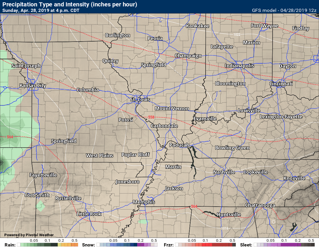
Remember, these are models. They are never 100% accurate. Take the general idea from them.
.
Here is the NAM 3K model guidance.
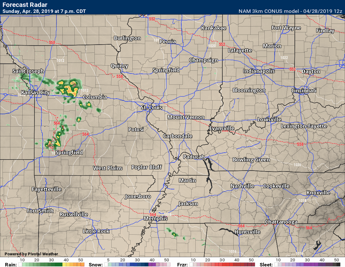
Time-stamp upper left.
Notice how the precip remains to our west for an extended period of time.
The precip moves closer on Wednesday/Wednesday night.
.
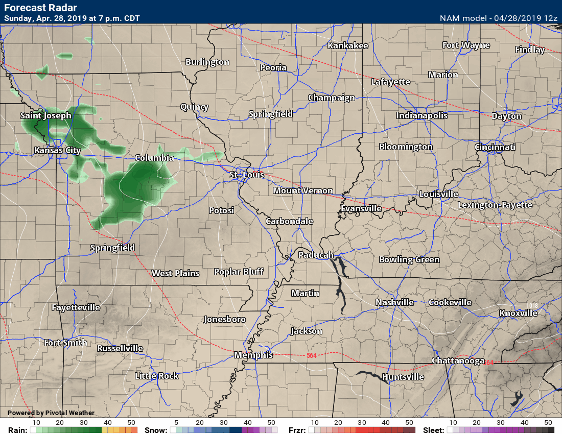
Here is the GFS future-cast radar. GFS is another model.
Notice how the precip remains to our west for an extended period of time.
The precip moves closer on Wednesday/Wednesday night.
The GFS is a bit faster with bringing the rain into our region.
Time-stamp upper left.
.
.
These maps update several times a day. Occasionally, in between updates, you may see a duplicate day or one out of sync.
Forty-eight-hour temperature outlook.


.

Radar Link: Interactive local city-view radars & regional radars.
You will find clickable warning and advisory buttons on the local city-view radars.
If the radar is not updating then try another one. If a radar does not appear to be refreshing then hit Ctrl F5. You may also try restarting your browser.
Not working? Email me at beaudodson@usawx.com
National map of weather watches and warnings. Click here.
Storm Prediction Center. Click here.
Weather Prediction Center. Click here.
.

Live lightning data: Click here.
.

Interactive GOES R satellite. Track clouds. Click here.
GOES 16 slider tool. Click here.
College of Dupage satellites. Click here
.

Here are the latest local river stage forecast numbers Click Here.
Here are the latest lake stage forecast numbers for Kentucky Lake and Lake Barkley Click Here.
.
Did you know that you can find me on Twitter? Click here to view my Twitter weather account.

.
Not receiving app/text messages?
- Make sure you have the correct app/text options turned on. Do that under the personal notification settings tab at www.weathertalk.com. Red is off. Green is on.
- USE THE APP. Verizon and ATT have been throttling text messages. The app receives the same messages instantly. Texts can take longer. Please, use the app. It is under Beau Dodson Weather in the app stores.


Tonight’s WeatherBrain features Dr. Harold Brooks from the National Severe Storms Laboratory. Dr. Brooks earned his undergraduate degree in physics and mathematics at William Jewell College outside of Kansas City and performed graduate study at Columbia University. Dr. Brooks earned his PhD on thunderstorm modeling at the University of Illinois.
In addition, our second Guest WeatherBrain Dr. Victor Gensini of Northern Illinois University joins us this week. Dr. Gensini earned his Masters Degree on severe thunderstorm climatology, and wrote his dissertation on severe thunderstorms and climate change. His current focus is on sub-seasonal to seasonal variability, and how that drives weather patterns across the United States. Gentleman, welcome to WeatherBrains!
Other discussions in this weekly podcast include topics like:
- Differences in severe weather events in Tornado Alley and Dixie Alley
- Future product in-between Watch and Warning to warn residents of manufactured homes?
- National Weather Round-up
- The Astronomy Report from Tony Rice
- and more!
.
.
Previous episodes can be viewed by clicking here.
.
Find Beau on Facebook! Click the banner.

.
Find Beau on Twitter! Share your weather photos! @beaudodson

Click here to go to the top of the page
Did you know that a portion of your monthly subscription helps support local charity projects? Not a subscriber? Becoming one at www.weathertalk.com
You can learn more about those projects by visiting the Shadow Angel Foundation website and the Beau Dodson News website.
