

.
You must have a Weather Talk subscription ($3 a month) to view the videos.
Videos are posted on the www.weathertalk.com website. Once there, click the Beau Video-Cast tab. Long Range Video Update
If you believe you missed a video then you can also click the LIVE FEED link on the Weather Talk website. You will find the most recent and previous seven days worth of links on that page.
I can app/text you the videos, as well. Make sure you have text option FOUR turned on. That would be the Weather Extra text option. Sign up for the app/text messages, videos, and more at www.beaudodsonweather.com
.

.
This forecast update covers southern Illinois, southeast Missouri, western Kentucky. and extreme northwest Tennessee.
.
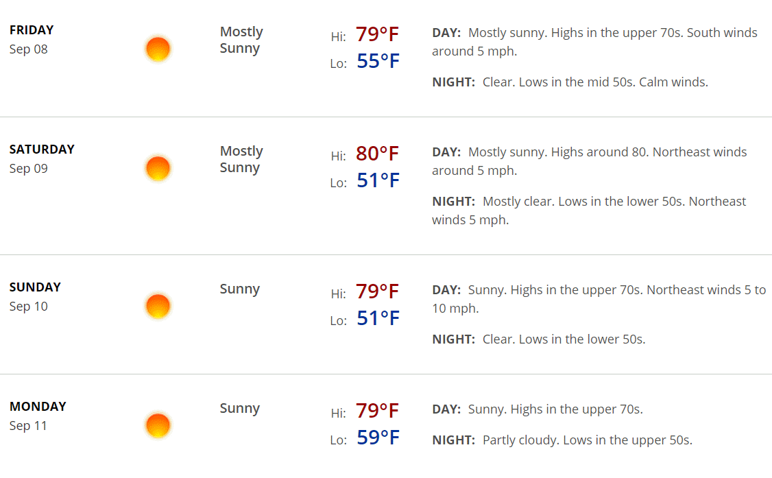
September 8, 2017
Friday Night Forecast Details:
Forecast: Mostly clear. Cool. Perhaps some patchy fog. A few passing clouds possible.
Temperatures: MO ~ 52 to 56 IL ~ 52 to 56 KY ~ 52 to 56 TN ~ 54 to 58
Winds: Light and variable at 0 to 5 mph
What impacts are anticipated from the weather? None
My confidence in the forecast verifying: High
Is severe weather expected? No
The NWS defines severe weather as 58 mph winds or great, 1″ hail or larger, and/or tornadoes
What is the chance of precipitation? MO ~ 0% IL ~ 0% KY ~ 0% TN ~ 0%
Coverage of precipitation: None
Should I cancel my outdoor plans? No
.
September 9, 2017
Saturday Forecast Details
Forecast: Mostly sunny. Pleasant temperatures.
Temperatures: MO ~ 78 to 82 IL ~ 78 to 82 KY ~ 78 to 82 TN ~ 78 to 82
Winds: Light and variable from the east at 0 to 10 mph
What impacts are anticipated from the weather? None
My confidence in the forecast verifying: High
Is severe weather expected? No
The NWS defines severe weather as 58 mph winds or great, 1″ hail or larger, and/or tornadoes
What is the chance of precipitation? MO ~ 0% IL ~ 0% KY ~ 0% TN ~ 0%
Coverage of precipitation: None
Should I cancel my outdoor plans? No
.
Saturday Night Forecast Details:
Forecast: Mostly clear.
Temperatures: MO ~ 52 to 56 IL ~ 52 to 56 KY ~ 52 to 56 TN ~ 52 to 56
Winds: Light and variable at 5 mph
What impacts are anticipated from the weather? None
My confidence in the forecast verifying: High
Is severe weather expected? No
The NWS defines severe weather as 58 mph winds or great, 1″ hail or larger, and/or tornadoes
What is the chance of precipitation? MO ~ 0% IL ~ 0% KY ~ 0% TN ~ 0%
Coverage of precipitation: None
Should I cancel my outdoor plans? No
.
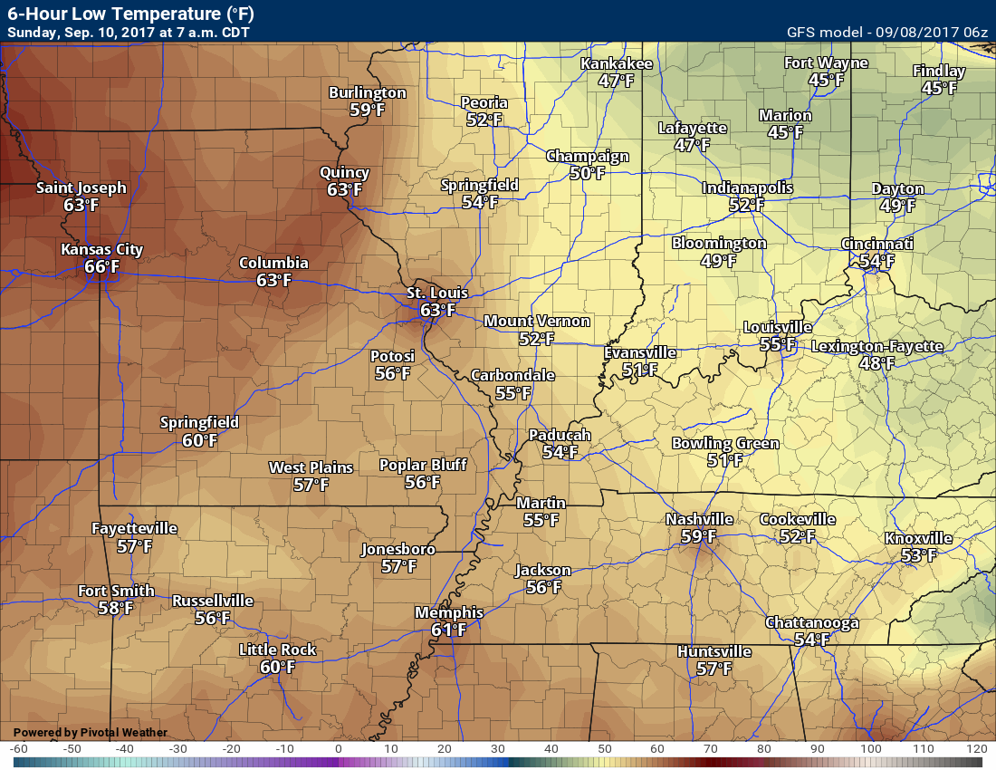
September 10, 2017
Sunday Forecast Details
Forecast: Mostly sunny. Pleasant temperatures.
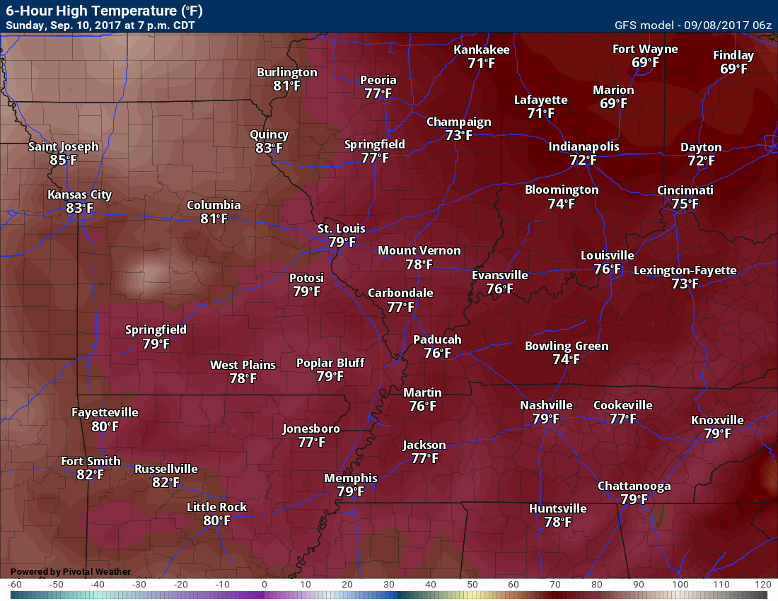
Temperatures: MO ~ 75 to 80 IL ~ 75 to 80 KY ~ 75 to 80 TN ~ 75 to 80
Winds: Light and variable winds becoming northeast at 4 to 8 mph
What impacts are anticipated from the weather? None
My confidence in the forecast verifying: High
Is severe weather expected? No
The NWS defines severe weather as 58 mph winds or great, 1″ hail or larger, and/or tornadoes
What is the chance of precipitation? MO ~ 0% IL ~ 0% KY ~ 0% TN ~ 0%
Coverage of precipitation: None
Should I cancel my outdoor plans? No
.
Sunday Night Forecast Details:
Forecast: Mostly clear. Cool temperatures.
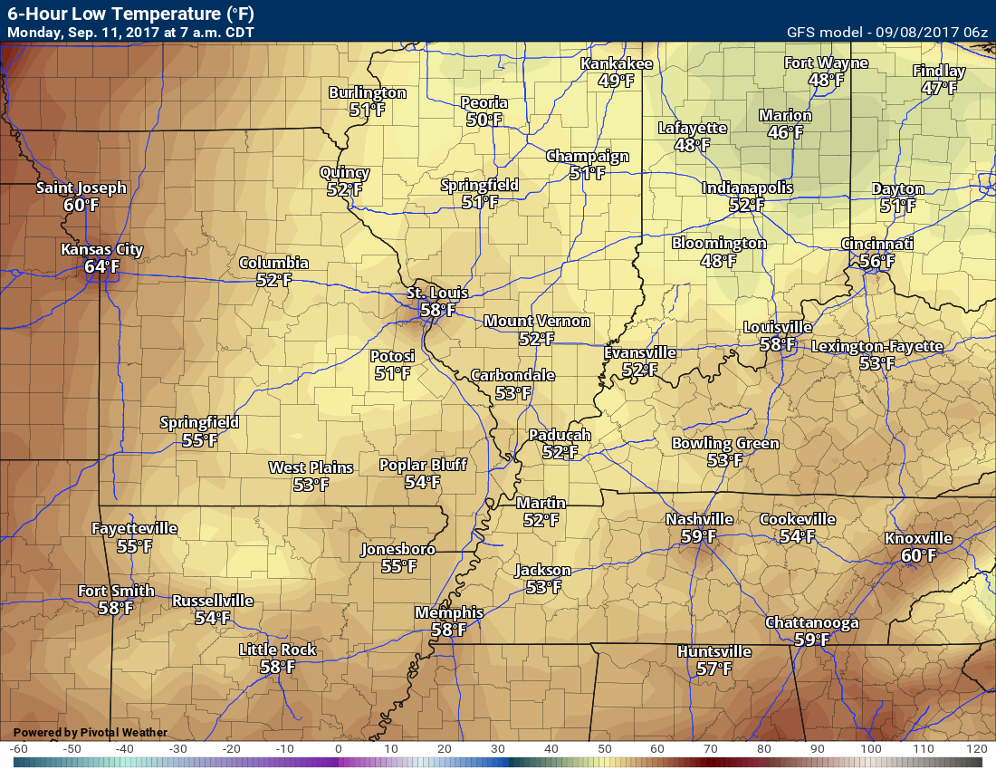
Temperatures: MO ~ 48 to 54 IL ~ 48 to 54 KY ~ 50 to 54 TN ~ 50 to 54
Winds: East and northeast at 5 mph
What impacts are anticipated from the weather? None
My confidence in the forecast verifying: High
Is severe weather expected? No
The NWS defines severe weather as 58 mph winds or great, 1″ hail or larger, and/or tornadoes
What is the chance of precipitation? MO ~ 0% IL ~ 0% KY ~ 0% TN ~ 0%
Coverage of precipitation: None
Should I cancel my outdoor plans? No
.
September 11, 2017
Monday Forecast Details
Forecast: Partly to mostly sunny. Pleasant temperatures.
Temperatures: MO ~ 75 to 80 IL ~ 75 to 80 KY ~ 75 to 80 TN ~ 75 to 80
Winds: Light and variable winds. Winds mostly north and northeast at 0 to 5 mph
What impacts are anticipated from the weather? None
My confidence in the forecast verifying: High
Is severe weather expected? No
The NWS defines severe weather as 58 mph winds or great, 1″ hail or larger, and/or tornadoes
What is the chance of precipitation? MO ~ 0% IL ~ 0% KY ~ 0% TN ~ 0%
Coverage of precipitation: None
Should I cancel my outdoor plans? No
.
Monday Night Forecast Details:
Forecast: Some clouds. Increasing clouds late.
Temperatures: MO ~ 54 to 58 IL ~ 54 to 58 KY ~ 54 to 58 TN ~ 54 to 58
Winds: Light and variable at 5 mph. Winds mostly northeast.
What impacts are anticipated from the weather? None
My confidence in the forecast verifying: High
Is severe weather expected? No
The NWS defines severe weather as 58 mph winds or great, 1″ hail or larger, and/or tornadoes
What is the chance of precipitation? MO ~ 0% IL ~ 0% KY ~ 0% TN ~ 0%
Coverage of precipitation: None
Should I cancel my outdoor plans? No
.
September 12, 2017
Tuesday Forecast Details
Forecast: Increasing clouds. Rain may increase as the remnants of Hurricane Irma approach. Gusty winds possible.
Temperatures: MO ~ 74 to 78 IL ~ 74 to 78 KY ~ 74 to 78 TN ~ 74 to 78
Winds: Variable wind direction. Winds gusting above 20 mph possible.
What impacts are anticipated from the weather? Wet roadways. Gusty winds possible.
My confidence in the forecast verifying: Medium
Is severe weather expected? Unlikely, but monitor
The NWS defines severe weather as 58 mph winds or great, 1″ hail or larger, and/or tornadoes
What is the chance of precipitation? MO ~ 40% IL ~ 40% KY ~ 50% TN ~ 50%
Coverage of precipitation: Increasing coverage possible after 12 pm
Should I cancel my outdoor plans? Monitor updates
.
Tuesday Night Forecast Details:
Forecast: Rain possible. Again, rain chances depend on Irma’s path.
Temperatures: MO ~ 55 to 60 IL ~ 55 to 60 KY ~ 55 to 60 TN ~ 55 to 60
Winds: Variable winds at 10 to 20 mph. Gusty winds possible.
What impacts are anticipated from the weather? Perhaps wet roadways. Gusty winds.
My confidence in the forecast verifying: Low
Is severe weather expected? Unlikely, but monitor updates
The NWS defines severe weather as 58 mph winds or great, 1″ hail or larger, and/or tornadoes
What is the chance of precipitation? MO ~ 40% IL ~ 40% KY ~ 50% TN ~ 50%
Coverage of precipitation: Scattered to numerous
Should I cancel my outdoor plans? Monitor updates
.
September 13, 2017
Wednesday Forecast Details
Forecast: Rain possible. Rain chances will be highly dependent on the path of Irma.
Temperatures: MO ~ 74 to 78 IL ~ 74 to 78 KY ~ 74 to 78 TN ~ 74 to 78
Winds:
What impacts are anticipated from the weather? Wet roadways. Gusty winds possible.
My confidence in the forecast verifying:
Is severe weather expected?
The NWS defines severe weather as 58 mph winds or great, 1″ hail or larger, and/or tornadoes
What is the chance of precipitation? MO ~ 40% IL ~ 40% KY ~ 50% TN ~ 50%
Coverage of precipitation:
Should I cancel my outdoor plans?
.
Wednesday Night Forecast Details:
Forecast: Rain possible. Again, rain chances depend on Irma’s path.
Temperatures: MO ~ 55 to 60 IL ~ 55 to 60 KY ~ 55 to 60 TN ~ 55 to 60
Winds:
What impacts are anticipated from the weather?
My confidence in the forecast verifying: Low
Is severe weather expected?
The NWS defines severe weather as 58 mph winds or great, 1″ hail or larger, and/or tornadoes
What is the chance of precipitation? MO ~ 40% IL ~ 40% KY ~ 50% TN ~ 50%
Coverage of precipitation:
Should I cancel my outdoor plans?
.

Don’t forget to check out the Southern Illinois Weather Observatory web-site for weather maps, tower cams, scanner feeds, radars, and much more! Click here
.

A severe thunderstorm is defined as a storm that produces quarter size hail or larger, 58 mph winds or greater, and/or a tornado. That is the official National Weather Service definition of a severe thunderstorm
Friday night through Tuesday: Severe weather is not anticipated. I will be monitoring the track of Irma. Some showers and thunderstorms could enter our forecast by Tuesday, Wednesday, and Thursday.
.

Overview
Are there any weather concerns
- Beautiful weekend
- I continue to track Irma. Will it bring rain into our region?
Short range
Confidence level in the short range forecast is high
I know it sounds like a broken record, but nice weather is going to continue into the weekend. I hope everyone is able to get out and enjoy the fresh air.
Temperatures will remain below normal through Sunday. High temperatures on both Saturday and Sunday should remain in the upper 70’s to around 80 degrees. Dew points will remain low, as well. Bottom line, nice weather!
Click image to enlarge
TEMPERATURE FORECAST
Click images to enlarge
Low temperatures for Friday night (below)
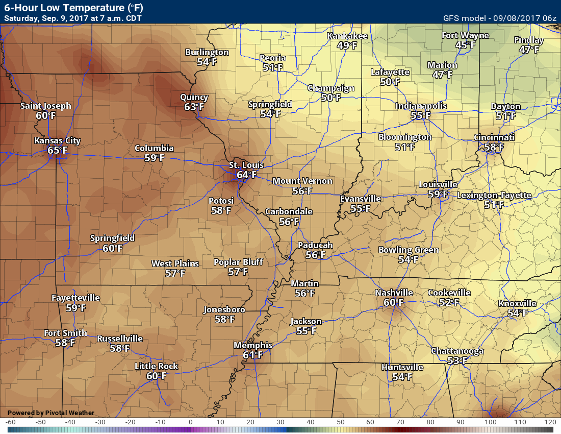
High temperatures for Saturday (below)
Low temperatures for Saturday night (below)
High temperatures for Sunday
Low temperatures for Sunday night
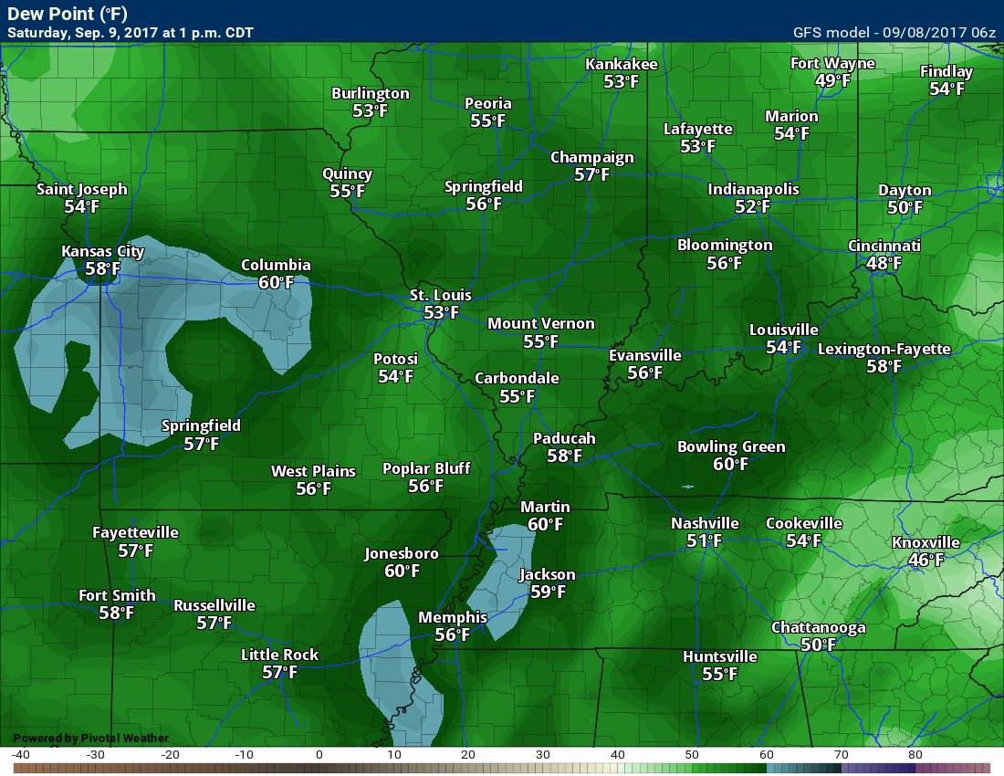
Dew point scale

Dew points for Saturday
Dew points for Sunday
Nice!

Dew points for Monday
Nice, again!

Long range
The confidence level is low to medium for the long range forecast.
No change in the forecast for next. Confidence is not all that great as to the eventual path of Hurricane Irma. It is possible that gusty winds and rain will move into our region towards the middle of the week. Again, not overly confident on the outcome.
At this time, it appears Irma will move northward through Florida and then into Georgia. There are questions after that time. Most guidance brings the system north and eventually northwest into the Tennessee Valley.
I hope to know more over the weekend.
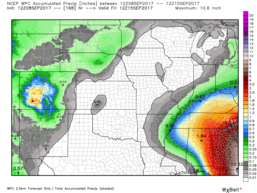
Let’s look at some model guidance and WPC forecasts.
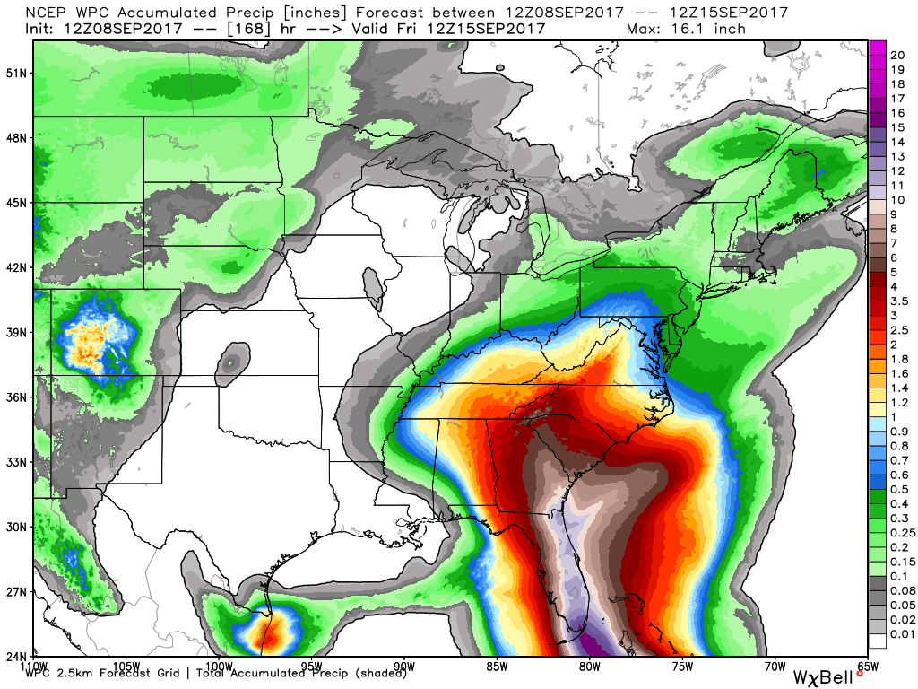
The WPC/NOAA seven day rainfall map does bring rain into our region. This would be because of Irma
Click to enlarge
Scale is on the right side of the map
See the path of Irma? Very heavy rain through Florida and then northward into Georgia and the Carolina’s. What happens after that time is the real question.
Zooming in
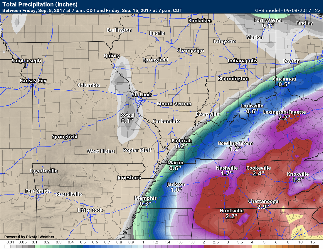
Here is the GFS model guidance forecast
Scale is on the bottom of the map
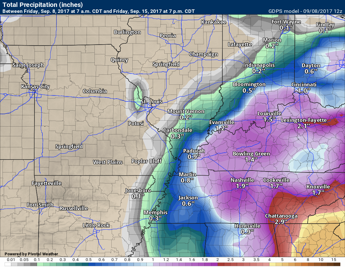
Canadian model guidance rainfall forecast
Click to enlarge
Scale on the bottom of the map
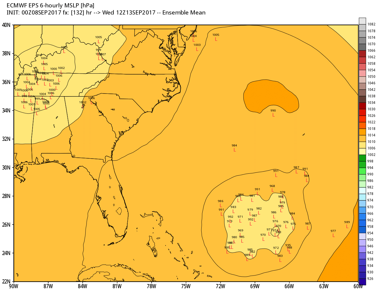
EC (European model guidance) rainfall forecast
Click images to enlarge
Scale is on the bottom of this map
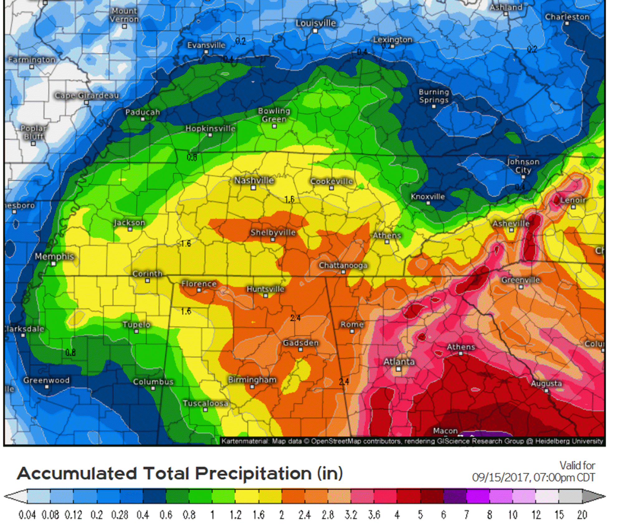
The EC guidance is showing a west track. Notice that these L’s are clustered on the west side of most guidance.
The red L’s are the center of the hurricane. These are ensemble members from the EC guidance.
Ensemble forecasting is a method used in numerical weather prediction. Instead of making a single forecast of the most likelyweather, a set (or ensemble) of forecasts are produced. This set offorecasts aims to give an indication of the range of possible future states of the atmosphere.
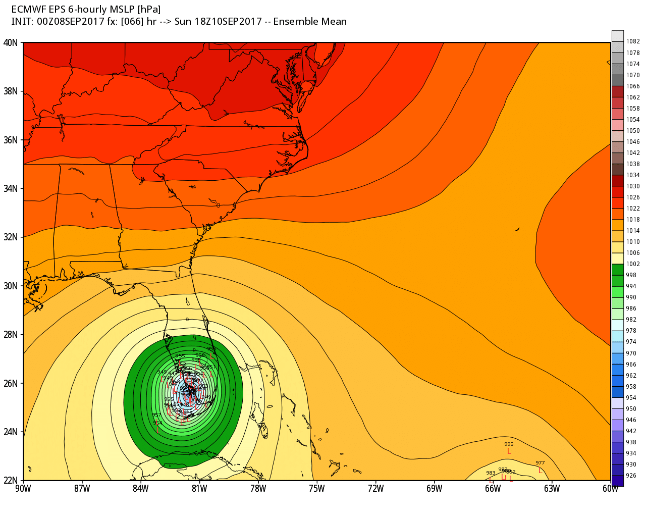
Notice the EC then brings the low pressure into our region. The low pressure center would be the red L’s.
HURRICANE IRMA
I am closely monitoring Hurricane Irma. It is starting to look like Irma will bring rain into our region by the middle of next week. Confidence remains low.
Here is the official track forecast from the National Hurricane Center
Focus on the white CONE. Do not focus on the center point. The cone represents where the eye of the hurricane could pass. The eye is where the heaviest winds are normally located.
It would weaken by the time it arrives in our region.
The CONE is the white area
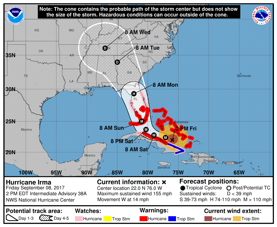
Zooming in on the path-cast
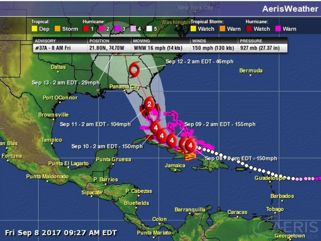

If you have friends or family in the forecast track cone, then I would encourage you to tell them to listen to local emergency officials. This is a dangerous hurricane with the potential of great destruction.
Are you subscribing to the Weather Talk texts and videos?
We now have premiere videos for the short and long range forecasts! Make sure you have text option four turned on (green).
Sign up at www.beaudodsonweather.com
We also have an Apple and Android app (scroll down to bottom of the page for more information)

Were you aware that I have hired some help for long range videos? Short range videos, as well. An amazing team of meteorologists.
Click the link below to read more
http://cms.weathertalk.com/meet-the-team/
Weather Talk subscribers now have some of the best short and long range weather videos produced across the eastern United States.
.


We have regional radars and local city radars – if a radar does not update then try another one. Occasional browsers need their cache cleared. You may also try restarting your browser. That usually fixes the problem. Occasionally we do have a radar go down. That is why I have duplicates. Thus, if one fails then try another one.
During the winter you can track snow and ice by clicking the winterize button on the local city view interactive radars.
If you have any problems then please send me an email beaudodson@usawx.com
Interactive Weather Radar Page. Choose the city nearest your location: Click this link
National interactive radar: Click this link.
Local interactive city radars include St Louis, Mt Vernon, Evansville, Poplar Bluff, Cape Girardeau, Marion, Paducah, Hopkinsville, Memphis, Nashville, Dyersburg, and all of eastern Kentucky. These are interactive radars. Local city radars – click here
The Beau Dodson Weather APP is ready for Apple and Android users. The purpose of this app is for me to deliver your app/text messages instantly. ATT and Verizon have not always been reliable when it comes to speed. The app allows instant delivery.
Some of you have asked if you can receive the texts on your phone and the app. The answer to that is, yes. The Android app will automatically allow that to happen. On the Apple app, however, you will need to go into your app and click settings. Make sure the green tab is OFF. Off means you will still receive the texts to your phone and the app. If you have any questions, then email me at beaudodson@usawx.com
The app is for text subscribers.
The direct download, for the Apple app, can be viewed here
https://itunes.apple.com/us/app/id1190136514
If you have not signed up for the texting service then you may do so at www.beaudodsonweather.com

The Android app is also ready.
Remember, the app’s are for www.weathertalk.com subscribers. The app allows your to receive the text messages faster than ATT and Verizon.
Here is the download link for the Android version Click Here

——————————————————–
If you have not signed up for the texts messages, then please do. Link www.beaudodsonweather.com
Your support helps with the following:

and


Who do you trust for your weather information and who holds them accountable?
I have studied weather in our region since the late 1970’s. I have 39 years of experience in observing our regions weather patterns. My degree is in Broadcast Meteorology and a Bachelor’s of Science.
My resume includes:
Member of the American Meteorological Society.
NOAA Weather-Ready Nation Ambassador.
Meteorologist for McCracken County Emergency Management. I served from 2005 through 2015.
Meteorologist for McCracken County Rescue. 2015 through current
I own and operate the Southern Illinois Weather Observatory.
I am the chief meteorologist for Weather Talk LLC. I am the owner of Weather Talk LLC.
I am also a business owner in western Kentucky.
Recipient of the Mark Trail Award, WPSD Six Who Make A Difference Award, Kentucky Colonel, and the Caesar J. Fiamma” Award from the American Red Cross.
In 2005 I helped open the largest American Cross shelter in U.S. history in Houston, Texas. I was deployed to help after Hurricane Katrina and Hurricane Rita. I was a shelter manager of one of the Houston, Texas shelter divisions.
In 2009 I was presented with the Kentucky Office of Highway Safety Award.
Recognized by the Kentucky House of Representatives for my service to the State of Kentucky leading up to several winter storms and severe weather outbreaks.
If you click on the image below you can read the Kentucky House of Representatives Resolution.

I am also President of the Shadow Angel Foundation which serves portions of western Kentucky and southern Illinois.
There is a lot of noise on the internet. A lot of weather maps are posted without explanation. Over time you should learn who to trust for your weather information.
My forecast philosophy is simple and straight forward.
- Communicate in simple terms
- To be as accurate as possible within a reasonable time frame before an event
- Interact with you on Twitter, Facebook, email, texts, and this blog
- Minimize the “hype” that you might see on some television stations or through other weather sources
- Push you towards utilizing wall-to-wall LOCAL TV coverage during severe weather events
Many of the graphics on this page are from www.weatherbell.com
WeatherBell is a great resource for weather model guidance.


You can sign up for my AWARE email by clicking here I typically send out AWARE emails before severe weather, winter storms, or other active weather situations. I do not email watches or warnings. The emails are a basic “heads up” concerning incoming weather conditions